Artículos similares a Map of Gard France with Pont du Gard and Wine Regions by Vuillemin, 19th c


¿Quieres más imágenes o vídeos?
Solicita imágenes o vídeos adicionales al vendedor
1 de 10
Map of Gard France with Pont du Gard and Wine Regions by Vuillemin, 19th c
140 €IVA incluido
Acerca del artículo
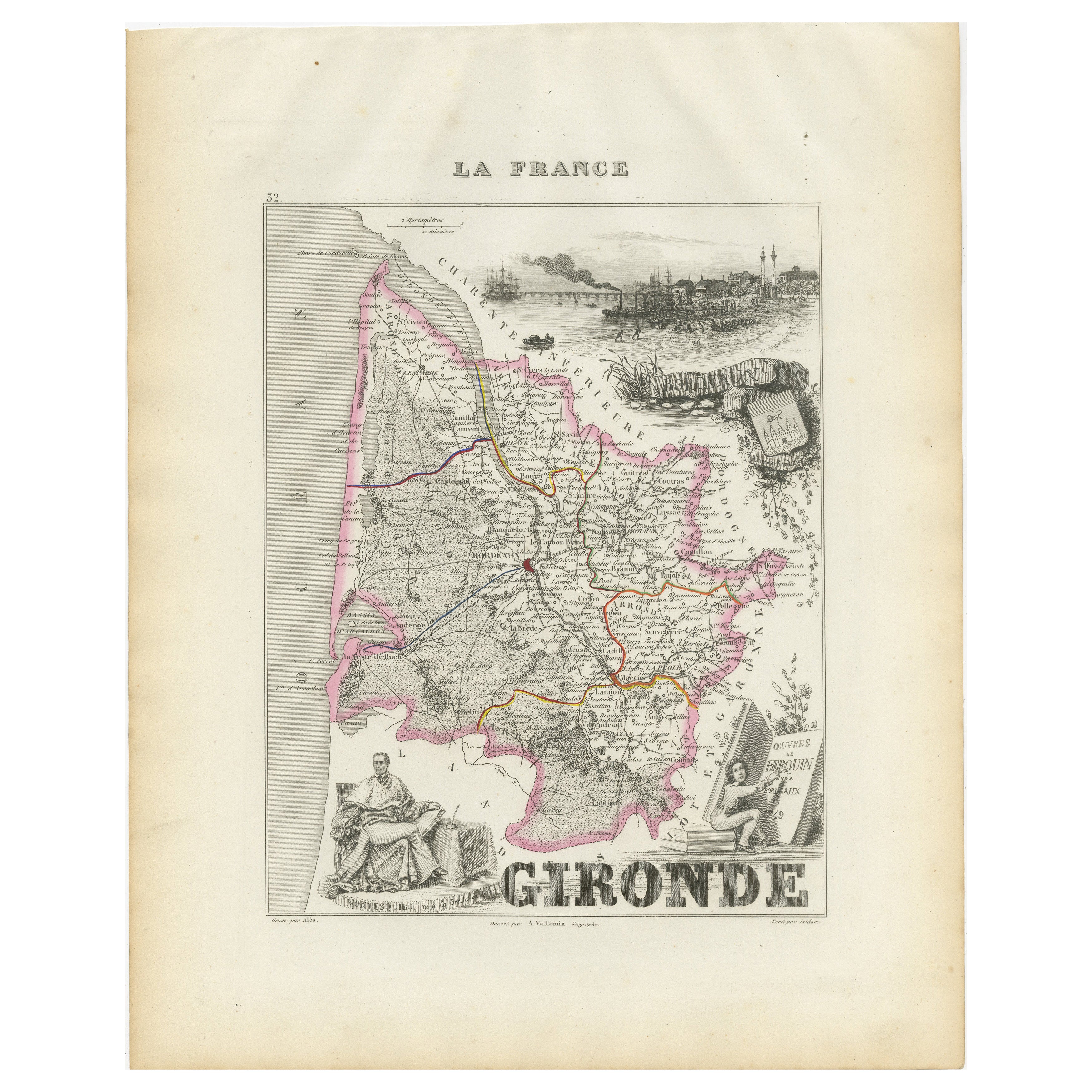
Title: Map of Gard France with Pont du Gard and Wine Regions by Vuillemin, 19th c
Description:
This finely engraved 19th-century map of the department of Gard in southern France was produced by Alexandre Vuillemin and published by Migeon in Paris as part of the *Nouvel Atlas Illustré*. The map blends detailed topographical information with artistic embellishments, offering a window into the geography, culture, and heritage of the region.
Gard is located in the Occitanie region and borders the Mediterranean Sea, Ardèche, Hérault, Bouches-du-Rhône, and Lozère. The map outlines the department with a fine hand-colored orange border and clearly marks towns, rivers, roadways, and topographic features. Nîmes, Uzès, Alès, and Beaucaire are among the many towns shown in detail.
At the lower left, a beautifully rendered vignette features the iconic **Pont du Gard**, a Roman aqueduct that stands as one of the most impressive and well-preserved Roman engineering feats in France. Built in the first century AD, it carried water to the city of Nîmes and remains a UNESCO World Heritage Site.
To the lower right, the map includes a portrait of **Jacques-Joseph de Gourbillon**, a local historical figure, with an unfurled map scroll and inscription. A coat of arms and botanical ornamentation add further decorative elements to the sheet.
Gard is also well known for its wine production, forming part of the greater **Côtes du Rhône** appellation. Vineyards near the Rhône River, including those around Tavel and Lirac, are especially notable. Tavel produces one of France’s most celebrated rosé wines, known for its full body, dry character, and historical reputation—it was said to be a favorite of Louis XIV and Ernest Hemingway. The department also produces reds and whites under the Costières de Nîmes and Duché d’Uzès AOCs, showcasing a blend of Mediterranean climate and Rhône varietals such as Syrah, Grenache, Mourvèdre, and Viognier.
Alexandre Vuillemin, a highly regarded French cartographer of the 19th century, was known for his clear yet decorative maps. His works with Migeon often included informative and picturesque features that made geography accessible and engaging to a broader audience.
Condition summary:
Very good condition with light age toning at the edges and a few minor foxing marks. The engraved detail remains sharp and the hand coloring is clean and well-preserved.
Framing tips:
Frame this map in a natural walnut or classic gold frame to enhance the historic charm. A warm ivory or pale terracotta mat will complement the orange border and Mediterranean tone of the subject. UV-protective glass is recommended for conservation.
- Dimensiones:Altura: 26,1 cm (10,28 in)Anchura: 32,5 cm (12,8 in)Profundidad: 0,2 mm (0,01 in)
- Materiales y técnicas:Papel,Grabado
- Lugar de origen:
- Época:
- Fecha de fabricación:circa 1850
- Estado:Very good condition with light age toning at the edges and a few minor foxing marks. The engraved detail remains sharp and the hand coloring is clean and well-preserved.
- Ubicación del vendedor:Langweer, NL
- Número de referencia:Vendedor: BG-13331-291stDibs: LU3054345363922
Sobre el vendedor
5,0
Vendedor reconocido
Estos prestigiosos vendedores son líderes del sector y representan el escalón más alto en cuanto a calidad y diseño de artículos.
Vendedor Platino
Vendedores premium con una calificación de +4,7 y tiempos de respuesta de 24 horas
Establecido en 2009
Vendedor de 1stDibs desde 2017
2655 ventas en 1stDibs
Tiempo de respuesta usual: <1 hora
- EnvíoRecuperando presupuesto…Envío desde: Langweer, Países Bajos
- Política de devolución
Partes de esta página se han traducido automáticamente. 1stDibs no puede garantizar la exactitud de las traducciones. El inglés es el idioma predeterminado de este sitio web.
Garantía de autenticidad
En el improbable caso de que haya algún problema con la autenticidad de un artículo, ponte en contacto con nosotros en un plazo de 1 año para recibir un reembolso total. DetallesGarantía de devolución de dinero
Si tu artículo no es como se describe, sufre daños durante el transporte o no llega, ponte en contacto con nosotros en un plazo de 7 días para recibir un reembolso total. DetallesCancelación dentro de las 24 horas
Tienes un período de gracia de 24 horas para reconsiderar tu compra, sin preguntas.Vendedores profesionales aprobados
Nuestros vendedores de primera clase deben cumplir estrictos estándares de servicio para mantener la integridad de nuestros anuncios.Garantía de igualación de precios
Si encuentras que un vendedor publicó el mismo artículo por un precio menor en otro lado, igualaremos ese precio.Entrega global de confianza
Nuestra red de transporte de primera ofrece opciones de envío especializado en todo el mundo, que incluye envío personalizado.Más de este vendedor
Ver todoMap of Allier France with Saint-Pourçain Wine Region by Vuillemin, 19th c
Map of Allier France with Saint-Pourçain Wine Region by Vuillemin, 19th c
This decorative 19th-century map of Allier, a central department of France, comes from the celebrated Nouve...
Categoría
Antiguo, Mediados del siglo XIX, Francés, Mapas
Materiales
Papel

Mapa de Gers, Francia, con Auch y la región vinícola de Armagnac, por Vuillemin, s. XIX
Mapa de Gers, Francia, con Auch y la región vinícola de Armagnac, por Vuillemin, s. XIX
Este mapa grabado y coloreado a mano del siglo XIX del departamento de Gers, en el suroeste d...
Categoría
Antiguo, Mediados del siglo XIX, Francés, Mapas
Materiales
Papel

Map of Côtes-du-Nord France with Saint-Brieuc and Brittany Coastline, c.1850
Map of Côtes-du-Nord France with Saint-Brieuc and Brittany Coastline, 19th c
Description:
This elegant 19th-century map of Côtes-du-Nord, the historic name for what is now known as ...
Categoría
Antiguo, Mediados del siglo XIX, Francés, Mapas
Materiales
Papel

Map of Ain France with Vineyards of Bugey and Notable Portraits, c.1850
Map of Ain France with Portraits of Bichat and Joubert by Vuillemin, 19th c
This highly decorative 19th-century map of the French department of Ain is taken from the celebrated Nouv...
Categoría
Antiguo, Mediados del siglo XIX, Francés, Mapas
Materiales
Papel

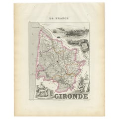
Mapa de la Gironda francesa con la región vinícola de Burdeos por Vuillemin, s. XIX
Mapa de la Gironda francesa con la región vinícola de Burdeos por Vuillemin, s. XIX
Este sorprendente mapa de la Gironda (Francia) del siglo XIX forma parte del Nouvel Atlas Illustr...
Categoría
Antiguo, Mediados del siglo XIX, Francés, Mapas
Materiales
Papel
Map of Aisne France with Soissons and Champagne Vineyards by Vuillemin, 19th c
Map of Aisne France with Soissons and Champagne Vineyards by Vuillemin, 19th c
Description:
This richly detailed 19th-century engraved and hand-colored map of the department of Aisn...
Categoría
Antiguo, Mediados del siglo XIX, Francés, Mapas
Materiales
Papel

También te puede gustar
Gran mapa de Francia del siglo XIX
Gran mapa de Francia del siglo XIX.
Notable estado, con una agradable pátina desgastada por el tiempo.
Recientemente enmarcado.
Francia Circa 1874.
Categoría
Antiguo, Fines del siglo XIX, Francés, Mapas
Materiales
Lino, Papel

Var, Francia. Mapa antiguo de un departamento francés, 1856
Por Victor Levasseur
Dept. du Var", grabado en acero con contorno original coloreado a mano, 1856, del Atlas National Illustre de Levasseur.
Var abarca el corazón de la Costa Azul, e incluye las ciudad...
Categoría
siglo XIX, Naturalista, Impresiones de paisajes
Materiales
Grabado

Saona y Loira, Francia. Mapa antiguo de un departamento francés, 1856
Por Victor Levasseur
Dept. de Saone et Loire", grabado en acero con contorno original coloreado a mano, 1856, del Atlas National Illustre de Levasseur.
El departamento francés de Saone et Loire está en...
Categoría
siglo XIX, Naturalista, Impresiones de paisajes
Materiales
Grabado

Aude, Francia. Mapa antiguo de un departamento francés, 1856
Por Victor Levasseur
"Dept. de L' Aude", grabado en acero con contorno original coloreado a mano., 1856, del "Atlas National Illustre" de Levasseur.
Esta zona de Francia es famosa por su gran variedad ...
Categoría
siglo XIX, Naturalista, Impresiones de paisajes
Materiales
Grabado

Francia, Parte Norte. Mapa antiguo Century Atlas
El Atlas del Siglo. Francia, Parte Norte".
Mapa antiguo original, 1903.
Mapas en recuadro de "Francia en provincias" y "París y alrededores".
Pliegue central como se emitió. Nombre...
Categoría
principios del siglo XX, Victoriano, Más impresiones
Materiales
Litografía

Mapa de Francia - Aguafuerte - 1820
Mapa de Francia es un Grabado Original realizado por un artista desconocido del siglo XIX en 1820.
Muy buen estado en dos hojas de papel blanco unidas por el centro.
El mapa es un ...
Categoría
Década de 1820, Moderno, Impresiones figurativas
Materiales
Grabado químico
