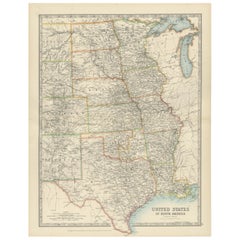
Artículos similares a Map of the Southeastern USA and Atlantic States – Vintage 1903 Geography
¿Quieres más imágenes o vídeos?
Solicita imágenes o vídeos adicionales al vendedor
1 de 10
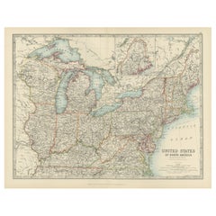
Map of the Southeastern USA and Atlantic States – Vintage 1903 Geography
Acerca del artículo
Map of the Southeastern USA and Atlantic States – Vintage 1903 Geography
This original engraved map, titled “United States of North America (South Eastern Sheet) with the Atlantic States,” was meticulously prepared by Keith Johnston and published in the early 1900s. It offers an intricately detailed representation of the southeastern region of the United States, including the Gulf of Mexico, the southern Atlantic coast, and the states of Georgia, Alabama, Mississippi, Louisiana, Florida, South Carolina, North Carolina, Tennessee, and beyond. An inset map captures the urban areas of Boston and Philadelphia with fine clarity, providing additional historical perspective on these prominent cities during the early 20th century.
The cartographic detail is impressive, showcasing not only state boundaries but also county divisions, major railroads, rivers, and mountain ranges, all in beautifully engraved lines with color outlining the states. The typography is precise and easy to read, adding a decorative touch to the map’s historical character. With the Atlantic Ocean labeled in classic script and the inclusion of neighboring Bahama Islands, this map gives a comprehensive view of trade routes and maritime significance during that period.
Condition is excellent for its age, with only minor aging or marginal imperfections that do not detract from its presentation. The engraved lines and colored boundaries remain vivid, offering a crisp visual appeal perfect for display or collection.
This map would look splendid framed in a classic or antique-style wooden frame, perhaps with a warm, natural finish to complement the vintage aesthetic. For the mat, consider cream or off-white to highlight the fine engraving. Ideal for anyone with a passion for American history, cartography, or antique décor, this map stands as both a piece of art and a window into the past.
- Dimensiones:Altura: 36,8 cm (14,49 in)Anchura: 47 cm (18,51 in)Profundidad: 0,2 mm (0,01 in)
- Materiales y técnicas:
- Época:
- Fecha de fabricación:1903
- Estado:Condition is excellent for its age, with only minor aging or marginal imperfections that do not detract from its presentation. The engraved lines and colored boundaries remain vivid, offering a crisp visual appeal perfect for display or collection.
- Ubicación del vendedor:Langweer, NL
- Número de referencia:Vendedor: BG-13577-461stDibs: LU3054345291802
Sobre el vendedor
5,0
Vendedor reconocido
Estos prestigiosos vendedores son líderes del sector y representan el escalón más alto en cuanto a calidad y diseño de artículos.
Vendedor Oro
Vendedores premium que mantienen una calificación de +4,3 y tiempos de respuesta de 24 horas
Establecido en 2009
Vendedor de 1stDibs desde 2017
2467 ventas en 1stDibs
Tiempo de respuesta usual: 1 hora
- EnvíoRecuperando presupuesto…Envío desde: Langweer, Países Bajos
- Política de devolución
Partes de esta página se han traducido automáticamente. 1stDibs no puede garantizar la exactitud de las traducciones. El inglés es el idioma predeterminado de este sitio web.
Garantía de autenticidad
En el improbable caso de que haya algún problema con la autenticidad de un artículo, ponte en contacto con nosotros en un plazo de 1 año para recibir un reembolso total. DetallesGarantía de devolución de dinero
Si tu artículo no es como se describe, sufre daños durante el transporte o no llega, ponte en contacto con nosotros en un plazo de 7 días para recibir un reembolso total. DetallesCancelación dentro de las 24 horas
Tienes un período de gracia de 24 horas para reconsiderar tu compra, sin preguntas.Vendedores profesionales aprobados
Nuestros vendedores de primera clase deben cumplir estrictos estándares de servicio para mantener la integridad de nuestros anuncios.Garantía de igualación de precios
Si encuentras que un vendedor publicó el mismo artículo por un precio menor en otro lado, igualaremos ese precio.Entrega global de confianza
Nuestra red de transporte de primera ofrece opciones de envío especializado en todo el mundo, que incluye envío personalizado.Más de este vendedor
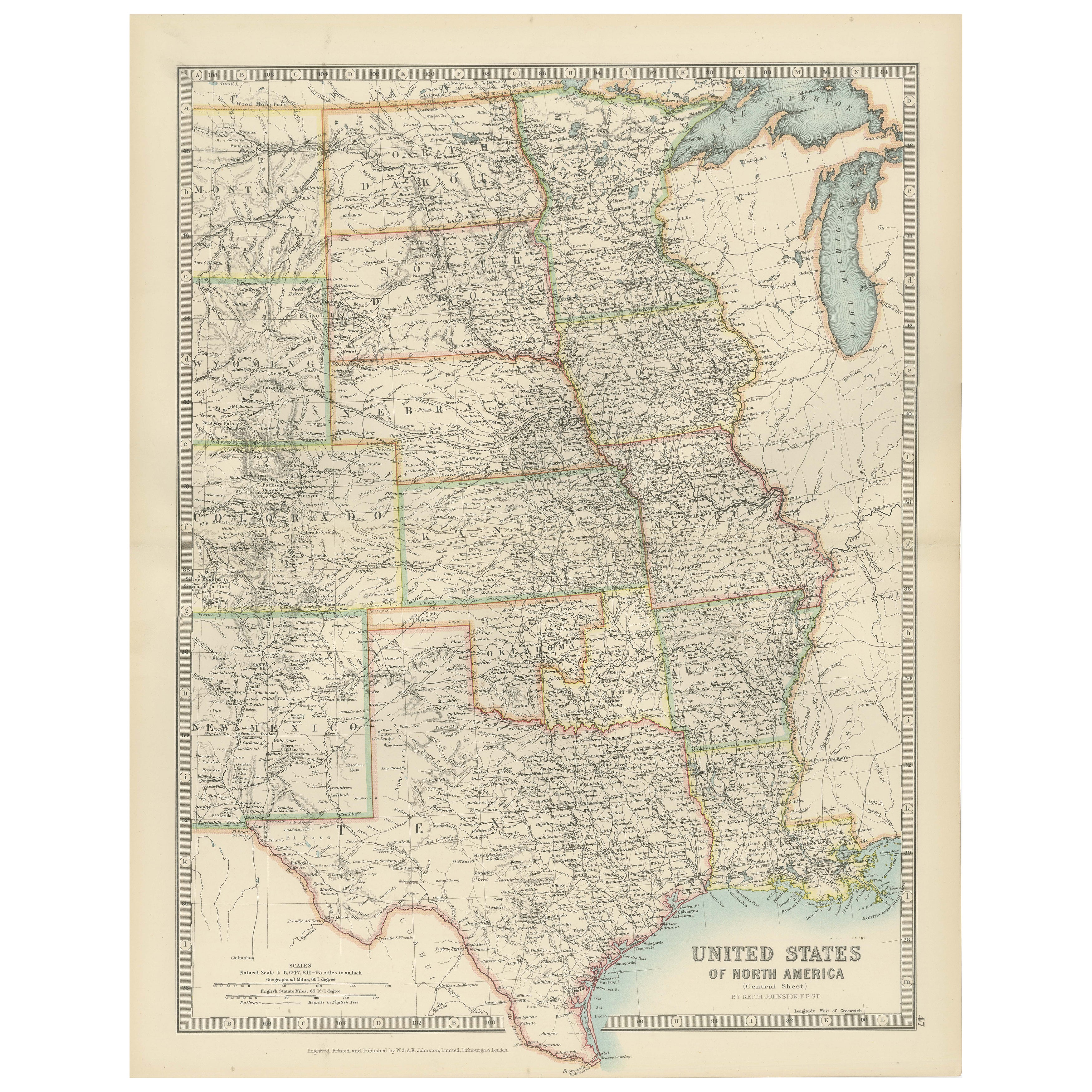
Ver todoMap of United States Central Sheet 1903 – Railroads, States, and Topography
Map of United States Central Sheet 1903 – Railroads, States, and Topography
This is a finely engraved and beautifully colored map titled "United States of North America (Central She...
Categoría
principios del siglo XX, Mapas
Materiales
Papel
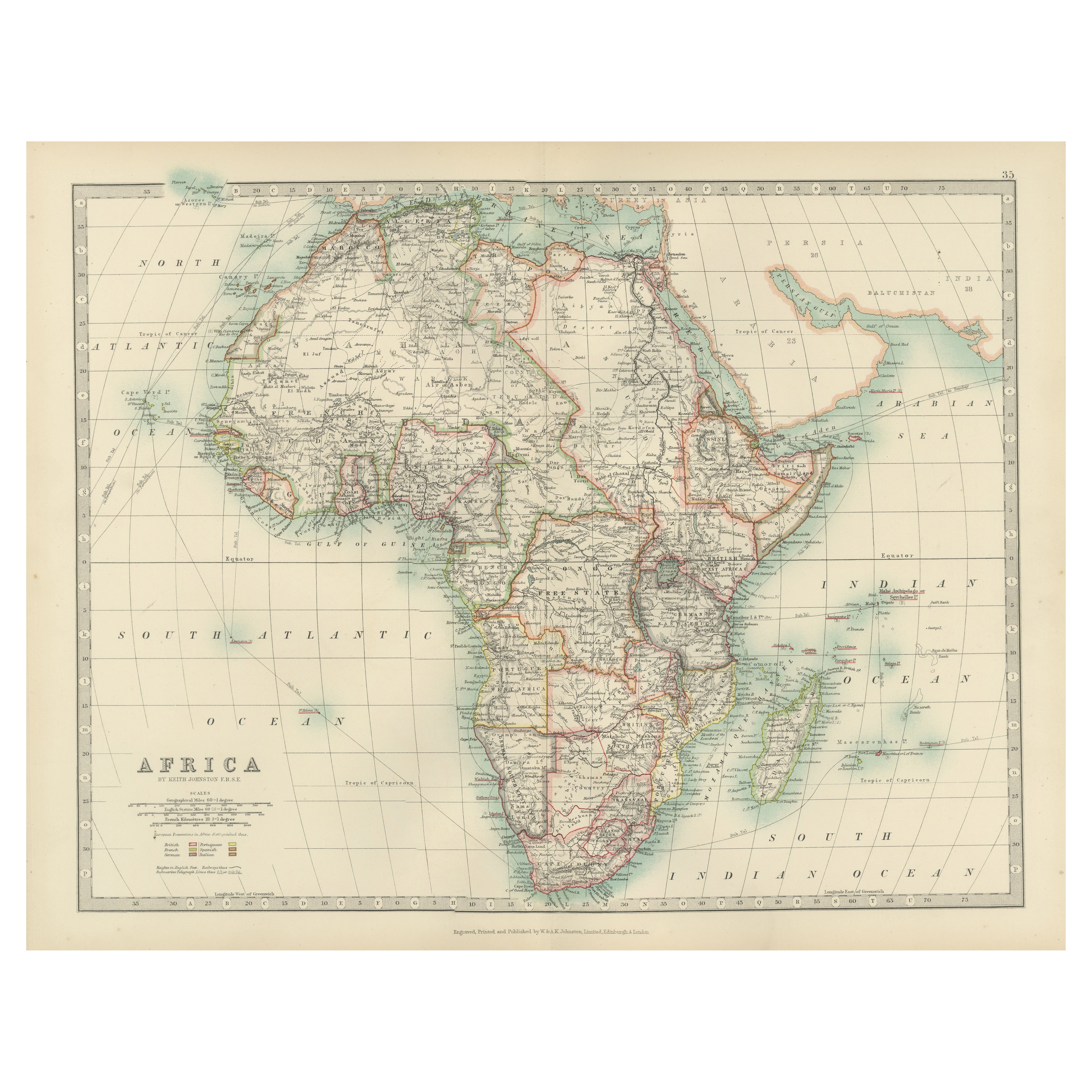
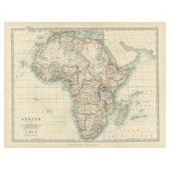
Antique Map of Africa, Highlighting Colonial Divisions, Geographic Features 1903
Title: Antique Map of Africa, 1903, Highlighting Colonial Divisions and Geographic Features
Description: This antique map, titled "Africa," was engraved and published in 1903 by W. ...
Categoría
principios del siglo XX, Mapas
Materiales
Papel
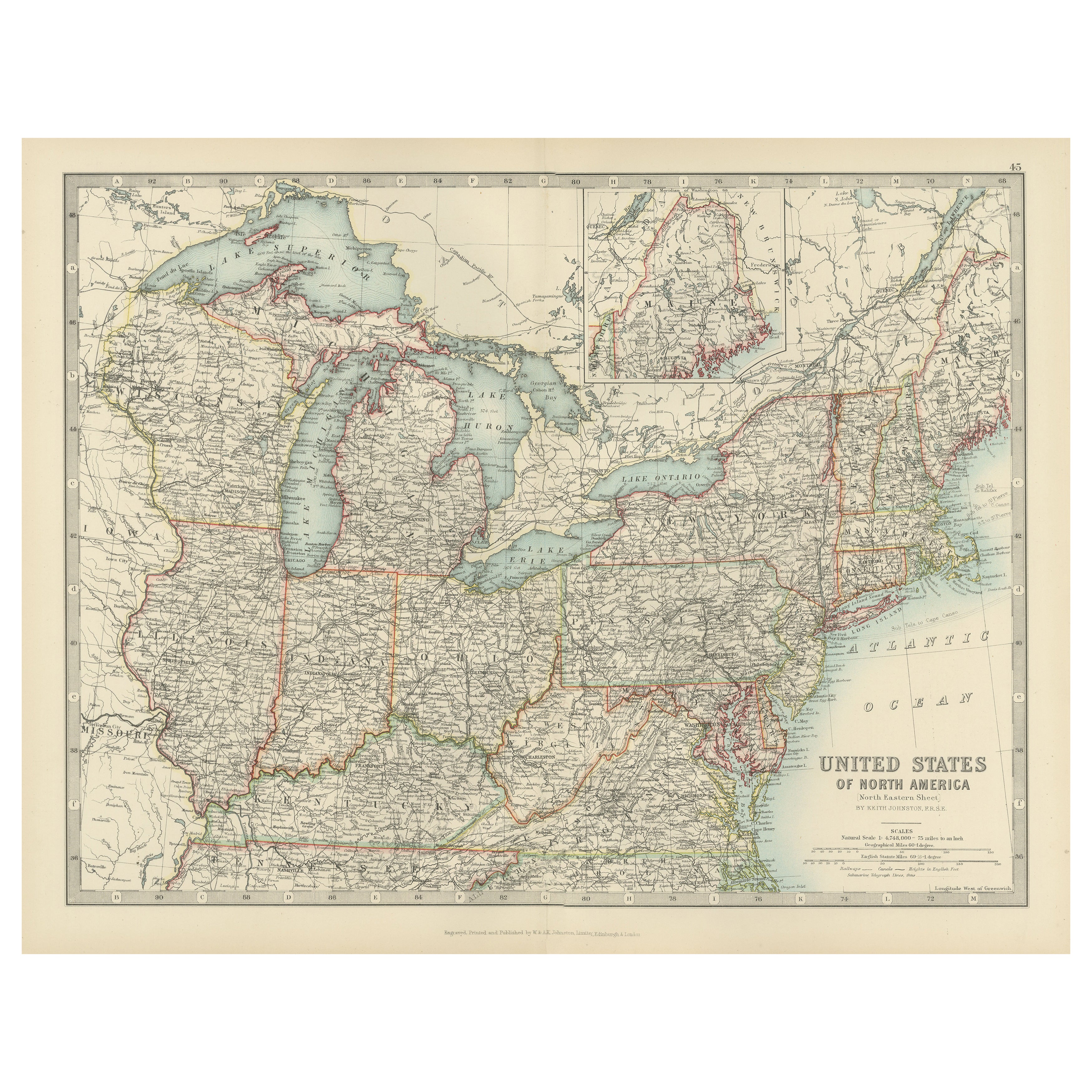
Antique Map of the Northeast USA - Vibrant 1903 Cartographic Detail
Map of the Northeastern United States of North America, 1903
This striking antique map titled “United States of North America (North Eastern Sheet)” was created by the renowned Scot...
Categoría
principios del siglo XX, Mapas
Materiales
Papel
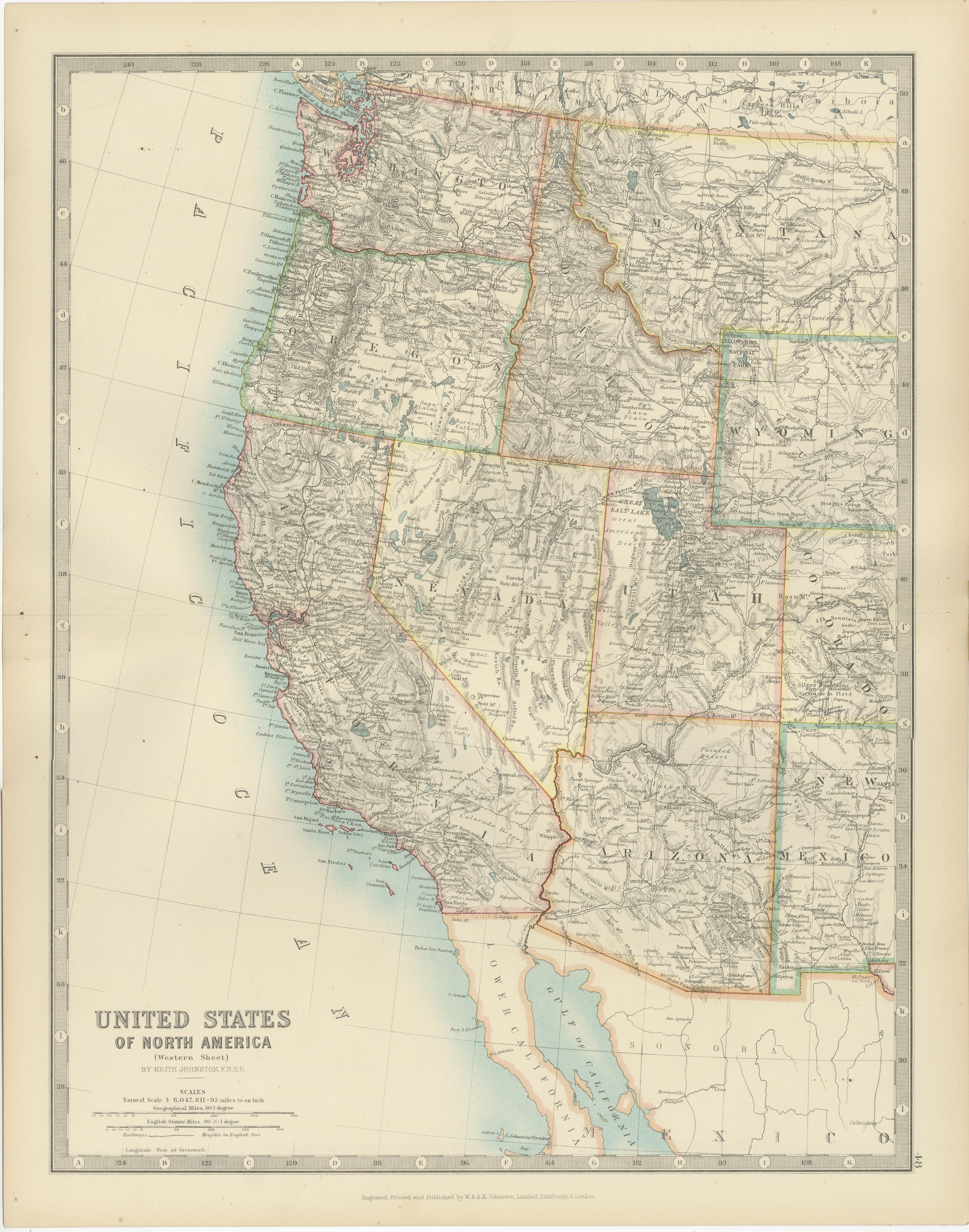
Map of Western United States 1903 – Railroads, State Borders, and Terrain
Map of Western United States 1903 – Railroads, State Borders, and Terrain
This beautifully engraved map titled "United States of North America (Western Sheet)" was created by Keith ...
Categoría
principios del siglo XX, Mapas
Materiales
Papel

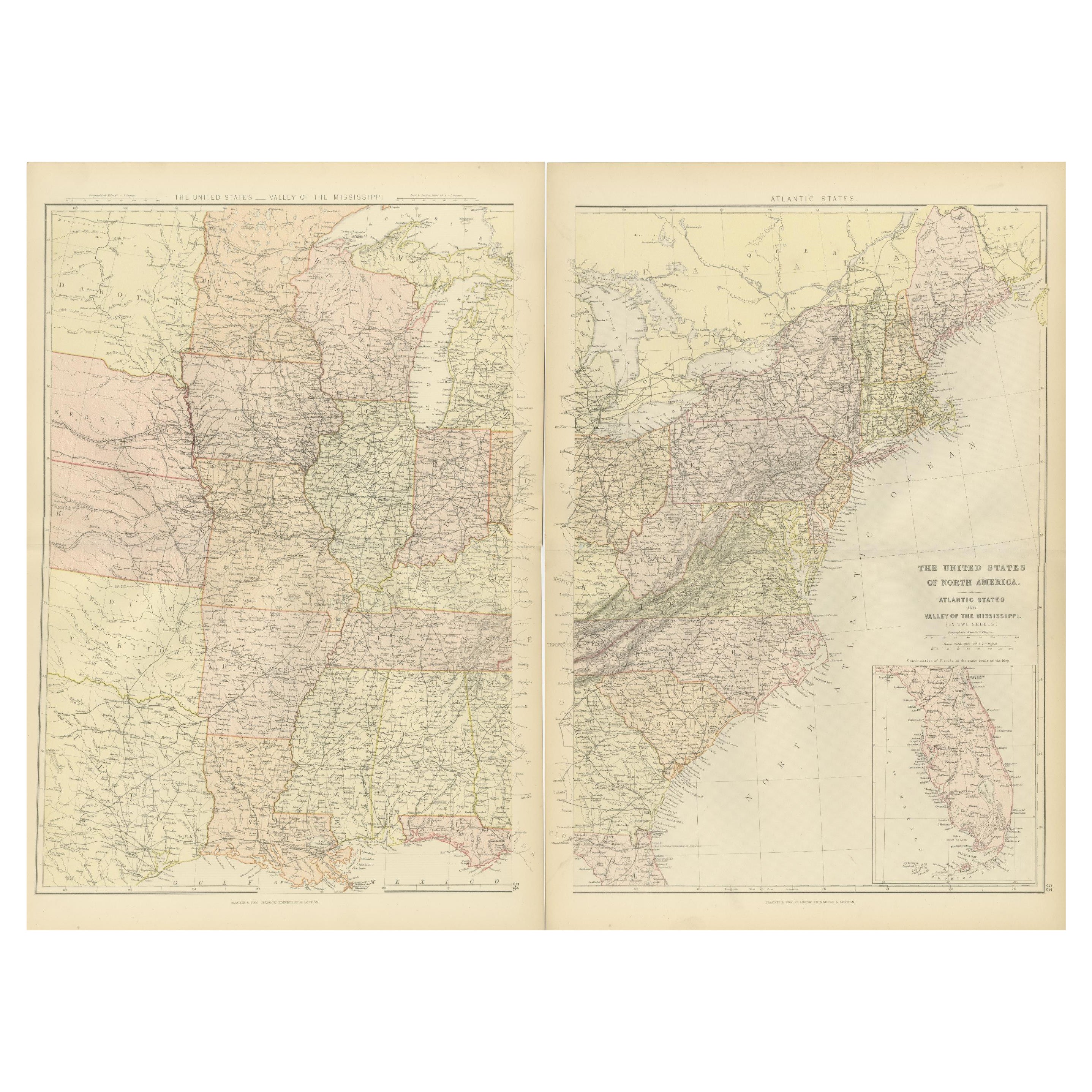
Mapas del Atlas Blackie de 1882: Recopilación de los Estados Atlánticos y el Valle del Mississippi
Estos dos mapas del Atlas Blackie de 1882 ofrecen una visión detallada de la mitad oriental de Estados Unidos, destacando las principales características geográficas, políticas y de ...
Categoría
Antiguo, Década de 1880, Mapas
Materiales
Papel
Mapa pequeño de Estados Unidos
Mapa antiguo titulado "Amérique septe. Físico". Pequeño mapa de Estados Unidos. Litografiado por los hermanos C. Callewaert en Bruselas hacia 1870.
Categoría
Antiguo, Mediados del siglo XIX, Mapas
Materiales
Papel

69 US$ Precio de venta
Descuento del 20 %
También te puede gustar
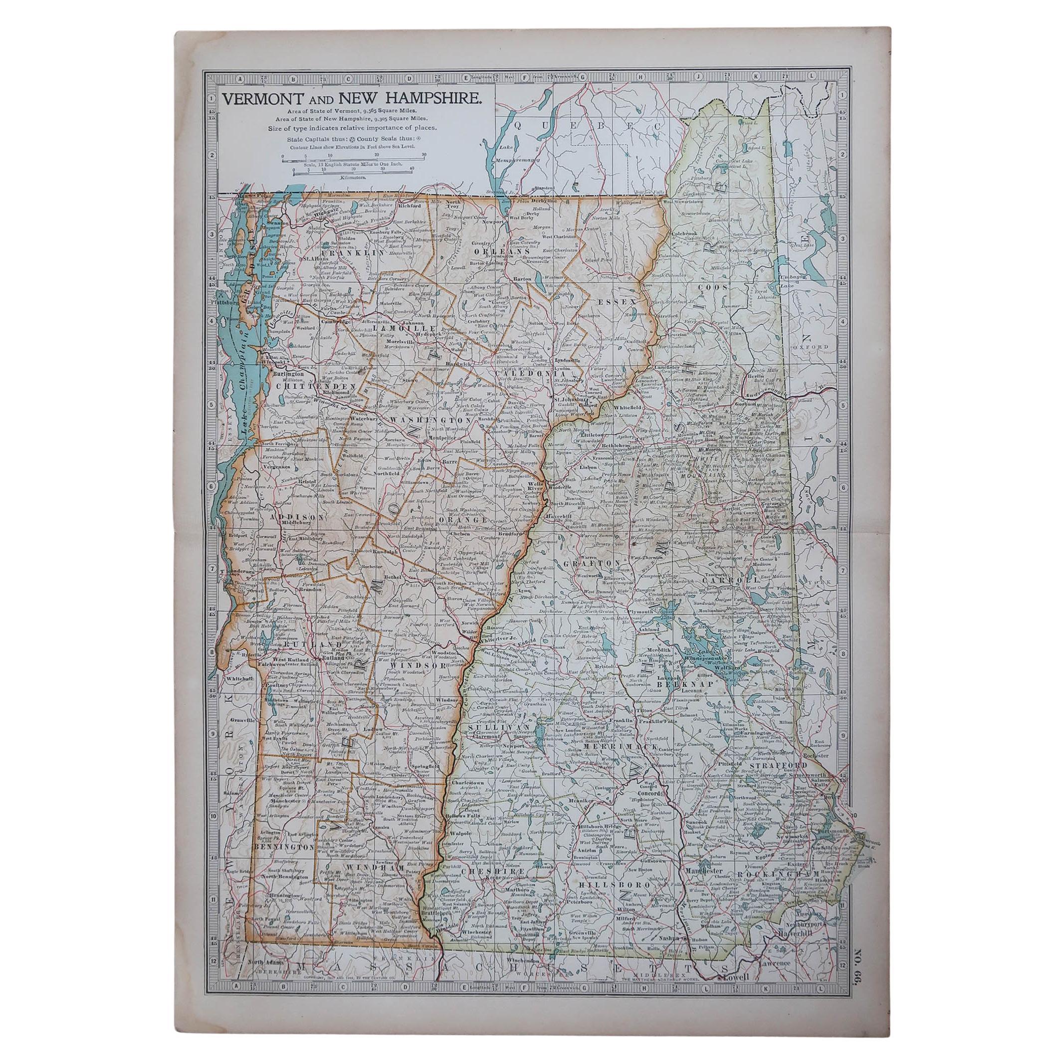
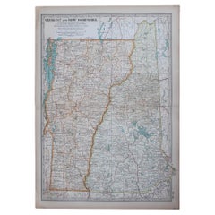
Mapa original antiguo de los estados americanos de Vermont y Nuevo Hampshire, 1903
Antique map of Vermont and New Hampshire
Published By A & C Black. 1903
Original colour
Good condition
Unframed.
Free shipping
Categoría
Antiguo, Principios del 1900, Inglés, Mapas
Materiales
Papel
Mapa Geográfico Antiguo del Principado de Mónaco
Por Bruno Santini
ST/609 - Interesante mapa antiguo en color del Principado de Mónaco en lengua francesa : "Carte qui contient le Principauté de Piémont, le Monferrat et la comté de Nice avec la Riviè...
Categoría
Antiguo, finales del siglo XVIII, Italiano, Otro, Mapas
Materiales
Papel

Grandes mapas antiguos de Estados Unidos, en 3 secciones, 1920
Grandes mapas de EE.UU. en 3 secciones
Sin enmarcar
Color original
Por John Bartholomew y Co. Instituto Geográfico de Edimburgo
Publicado, hacia 1920
Las medidas indicadas corre...
Categoría
Vintage, Década de 1920, Británico, Mapas
Materiales
Papel

Mapa de Estados Unidos Vintage Enmarcado
Mapa vintage de papel envejecido de Estados Unidos montado sobre tablero de partículas y enmarcado en un sencillo marco de madera.
Categoría
siglo XX, Estadounidense, Moderno de mediados de siglo, Mapas
Materiales
Madera, Papel

Mapa de Europa Sudoriental de Nicolas Visscher del siglo XVII
Un mapa precioso y muy detallado del sureste de Europa, obra de Nicolas Visscher. Incluye regiones del norte de Italia (mostrando las ciudades de Bolonia, Padua y Venecia), Bohemia, ...
Categoría
Antiguo, siglo XVII, Holandés, Mapas
Materiales
Papel

1350 US$ Precio de venta
Descuento del 38 %
Mapa original antiguo del estado norteamericano de Minnesota, 1903
Mapa antiguo de Minnesota
Publicado por A & C Black. 1903
Color original
Buen estado
Sin enmarcar.
Envío gratuito
Categoría
Antiguo, Principios del 1900, Inglés, Mapas
Materiales
Papel
