Artículos similares a Map of Western United States 1903 – Railroads, State Borders, and Terrain


¿Quieres más imágenes o vídeos?
Solicita imágenes o vídeos adicionales al vendedor
1 de 11
Map of Western United States 1903 – Railroads, State Borders, and Terrain
Acerca del artículo
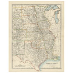
Map of Western United States 1903 – Railroads, State Borders, and Terrain
This beautifully engraved map titled "United States of North America (Western Sheet)" was created by Keith Johnston and published by W. & A.K. Johnston, Ltd. in London and Edinburgh, around 1903. It captures the western portion of the United States during a transformative period, showcasing states such as California, Oregon, Washington, Nevada, Idaho, Utah, Arizona, New Mexico, and parts of Montana, Wyoming, and Colorado.
This map is rich with historical detail, including an intricate network of railroads, key to the development of the western frontier in the early 20th century. State and county boundaries are carefully colored, while major rivers, mountain ranges, and settlements are precisely engraved, offering a glimpse into the growth of infrastructure and commerce. The typography is clean and refined, with town names, mountain peaks, and railway lines meticulously labeled.
Particularly interesting is the depiction of topography through delicate hachuring and shading, which brings the rugged beauty of the western landscape to life. The map also hints at the political and economic aspirations of the era, reflecting the westward expansion that defined the American experience.
The condition of this map is excellent for its age, with light toning around the edges and crisp, vibrant color that highlights the states and regions. It retains its charm and historical significance, making it a remarkable addition to any collection of antique maps or Americana.
For framing, a classic wooden frame in dark or natural tones would complement the historical aesthetic, while a neutral cream or soft tan mat would allow the detailed engravings to stand out. This map would make a wonderful centerpiece in an office, library, or living space, celebrating the rich heritage of the American West.
- Dimensiones:Altura: 47 cm (18,51 in)Anchura: 36,8 cm (14,49 in)Profundidad: 0,2 mm (0,01 in)
- Materiales y técnicas:
- Época:
- Fecha de fabricación:1903
- Estado:The condition is excellent for its age, with light toning around the edges and crisp, vibrant color that highlights the states and regions. It retains its charm and historical significance, making it a remarkable addition to any collection.
- Ubicación del vendedor:Langweer, NL
- Número de referencia:Vendedor: BG-13577-481stDibs: LU3054345291982
Sobre el vendedor
5,0
Vendedor reconocido
Estos prestigiosos vendedores son líderes del sector y representan el escalón más alto en cuanto a calidad y diseño de artículos.
Vendedor Oro
Vendedores premium que mantienen una calificación de +4,3 y tiempos de respuesta de 24 horas
Establecido en 2009
Vendedor de 1stDibs desde 2017
2463 ventas en 1stDibs
Tiempo de respuesta usual: <1 hora
- EnvíoRecuperando presupuesto…Envío desde: Langweer, Países Bajos
- Política de devolución
Partes de esta página se han traducido automáticamente. 1stDibs no puede garantizar la exactitud de las traducciones. El inglés es el idioma predeterminado de este sitio web.
Garantía de autenticidad
En el improbable caso de que haya algún problema con la autenticidad de un artículo, ponte en contacto con nosotros en un plazo de 1 año para recibir un reembolso total. DetallesGarantía de devolución de dinero
Si tu artículo no es como se describe, sufre daños durante el transporte o no llega, ponte en contacto con nosotros en un plazo de 7 días para recibir un reembolso total. DetallesCancelación dentro de las 24 horas
Tienes un período de gracia de 24 horas para reconsiderar tu compra, sin preguntas.Vendedores profesionales aprobados
Nuestros vendedores de primera clase deben cumplir estrictos estándares de servicio para mantener la integridad de nuestros anuncios.Garantía de igualación de precios
Si encuentras que un vendedor publicó el mismo artículo por un precio menor en otro lado, igualaremos ese precio.Entrega global de confianza
Nuestra red de transporte de primera ofrece opciones de envío especializado en todo el mundo, que incluye envío personalizado.Más de este vendedor
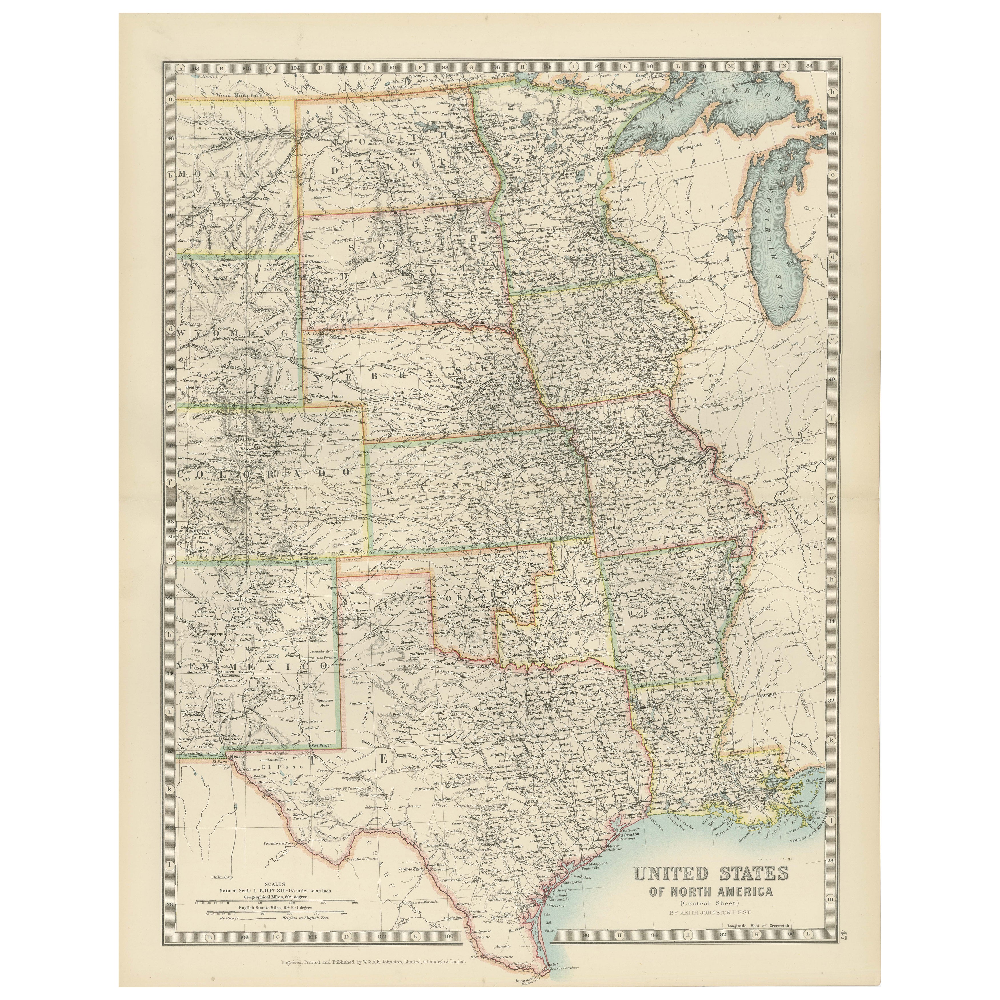
Ver todoMap of United States Central Sheet 1903 – Railroads, States, and Topography
Map of United States Central Sheet 1903 – Railroads, States, and Topography
This is a finely engraved and beautifully colored map titled "United States of North America (Central She...
Categoría
principios del siglo XX, Mapas
Materiales
Papel
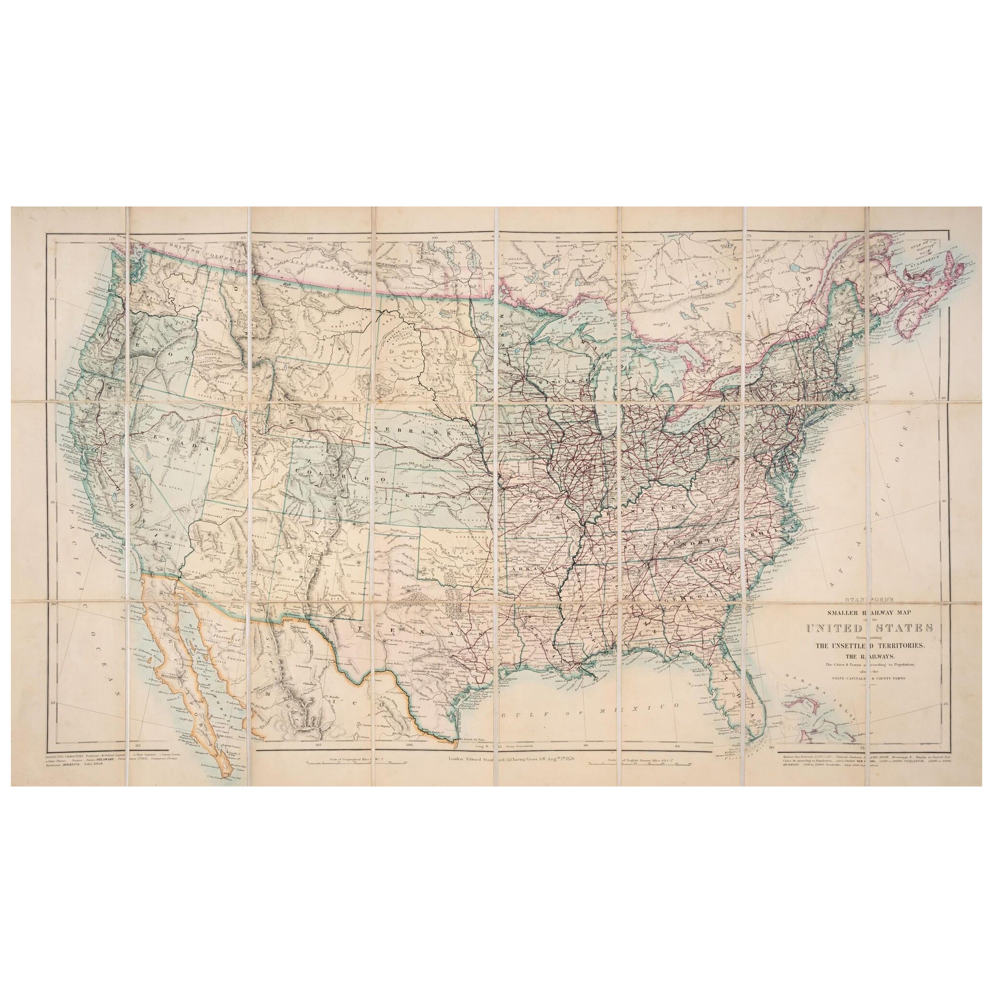
Mapa de Estados Unidos de 1876: Detallando las vías férreas y los territorios no colonizados
Mapa ferroviario más pequeño de Estados Unidos de Stanford, 1876
Este mapa original de 1876, titulado "Stanford's Smaller Railway Map of the United States Distinguishing the Unsettl...
Categoría
Antiguo, Década de 1870, Mapas
Materiales
Papel
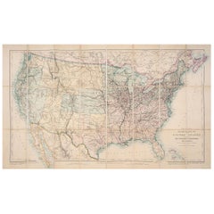
Antiguo mapa ferroviario de Estados Unidos por Rand, McNally & Co, 1900
Mapa antiguo titulado 'Rand, McNally & Co's New Official Railroad map of the United States with portions of The Dominion of Canada, The Republic of Mexico and the West Indies'. Gran ...
Categoría
siglo XX, Mapas
Materiales
Lino, Papel

2180 US$ Precio de venta
Descuento del 25 %
Envío gratuito
Mapa pequeño de Estados Unidos
Mapa antiguo titulado "Amérique septe. Físico". Pequeño mapa de Estados Unidos. Litografiado por los hermanos C. Callewaert en Bruselas hacia 1870.
Categoría
Antiguo, Mediados del siglo XIX, Mapas
Materiales
Papel

69 US$ Precio de venta
Descuento del 20 %
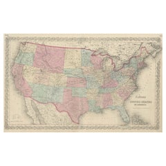
Mapa antiguo Colton's Estados Unidos de América
Mapa antiguo titulado "Estados Unidos de América de Colton". Muestra ferrocarriles, canales, capitales de estado, ciudades y pueblos importantes, puestos militares, senderos históric...
Categoría
Antiguo, Mediados del siglo XIX, Mapas
Materiales
Papel
827 US$ Precio de venta
Descuento del 20 %
Mapa antiguo de los Estados Unidos de América del Norte, Estados del Pacífico, 1882
El mapa procede del mismo Atlas Blackie de 1882 y se centra en los Estados del Pacífico de los Estados Unidos de América durante ese periodo. He aquí algunos detalles y el contexto h...
Categoría
Antiguo, Década de 1880, Mapas
Materiales
Papel

232 US$ Precio de venta
Descuento del 20 %
Envío gratuito
También te puede gustar
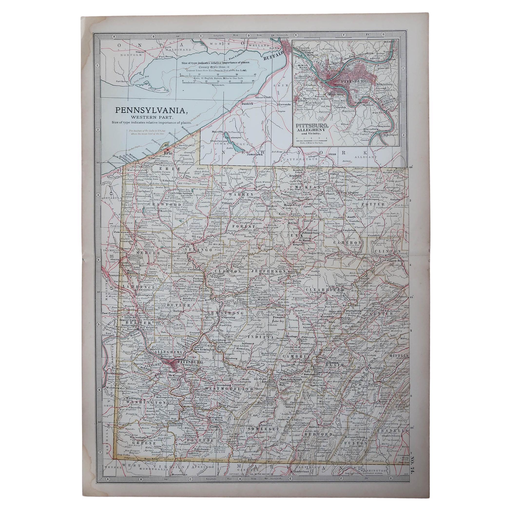
Mapa Antiguo Original del Estado Americano de Pensilvania( Parte Occidental ), 1903
Antique map of Pennsylvania ( Western part )
Published By A & C Black. 1903
Original colour
Good condition
Unframed.
Free shipping
Categoría
Antiguo, Principios del 1900, Inglés, Mapas
Materiales
Papel

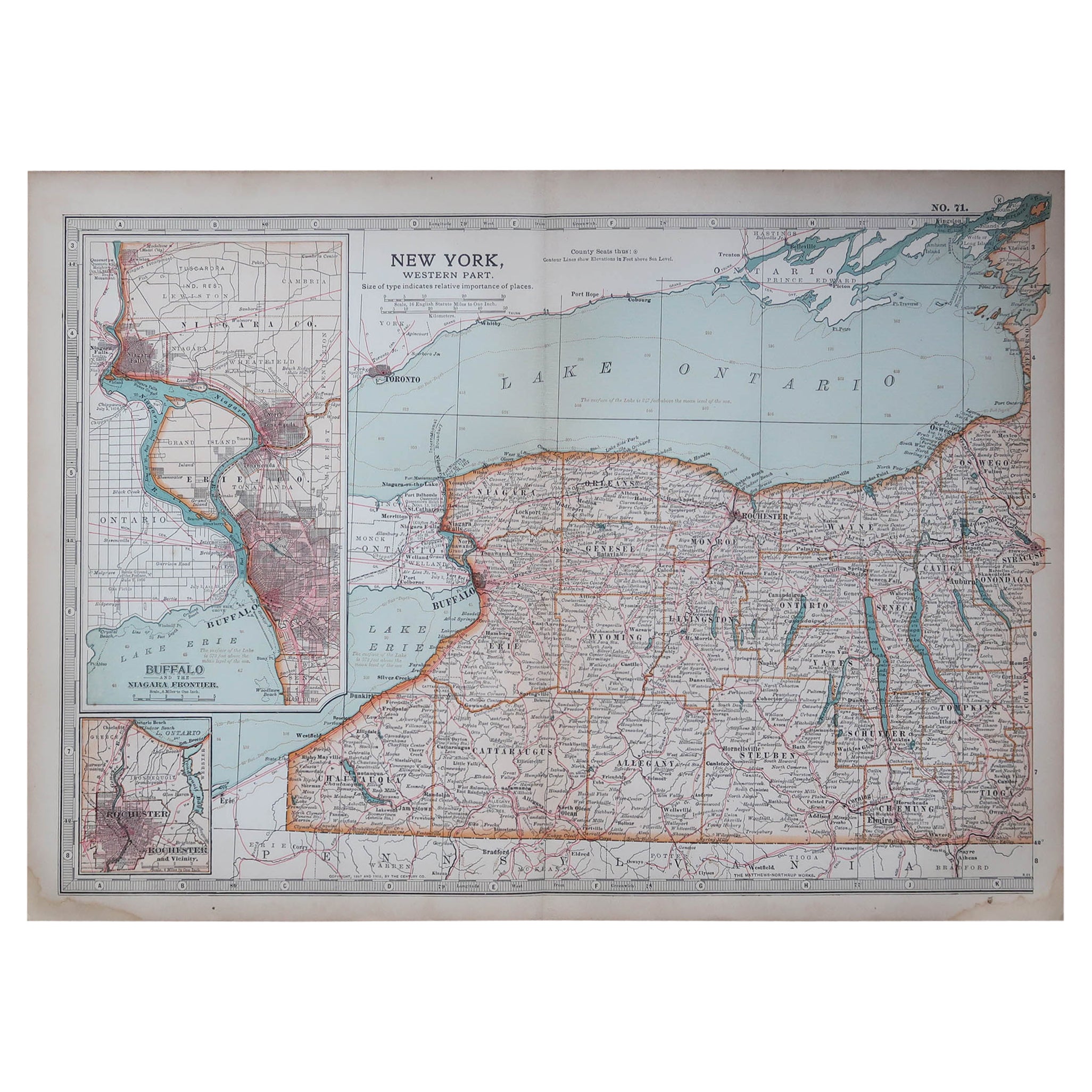
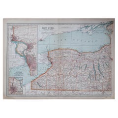
Mapa Antiguo Original del Estado Americano de Nueva York ( Parte Occidental ) 1903
Antique map of New York ( Western Part )
Published By A & C Black. 1903
Original colour
Good condition
Unframed.
Free shipping
Categoría
Antiguo, Principios del 1900, Inglés, Mapas
Materiales
Papel
Mapa de Estados Unidos Vintage Enmarcado
Mapa vintage de papel envejecido de Estados Unidos montado sobre tablero de partículas y enmarcado en un sencillo marco de madera.
Categoría
siglo XX, Estadounidense, Moderno de mediados de siglo, Mapas
Materiales
Madera, Papel

Mapa enmarcado de México y Estados Unidos de 1830
Mapa de América del Norte publicado hacia 1830. El mapa muestra la entrada de Estados Unidos en Canadá. México extendiéndose hasta el territorio de la Alta California. Texas aparece ...
Categoría
Antiguo, Década de 1830, Estadounidense, clásico estadounidense, Mapas
Materiales
Vidrio, Madera, Papel

Mapa original antiguo de Estados Unidos, Grattan y Gilbert, 1843
Gran mapa de Estados Unidos
Dibujado y grabado por Archer
Publicado por Grattan y Gilbert. 1843
Color original
Sin enmarcar.
Categoría
Antiguo, Década de 1840, Inglés, Mapas
Materiales
Papel

Mapa original antiguo del estado norteamericano de Minnesota, 1903
Mapa antiguo de Minnesota
Publicado por A & C Black. 1903
Color original
Buen estado
Sin enmarcar.
Envío gratuito
Categoría
Antiguo, Principios del 1900, Inglés, Mapas
Materiales
Papel
