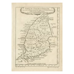
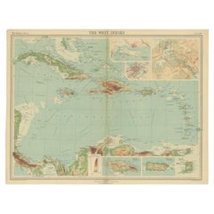
Antique Map of Grenada, West Indies, 1758
View Similar Items


Want more images or videos?
Request additional images or videos from the seller
1 of 7
Auction endedBrowse Current Auctions
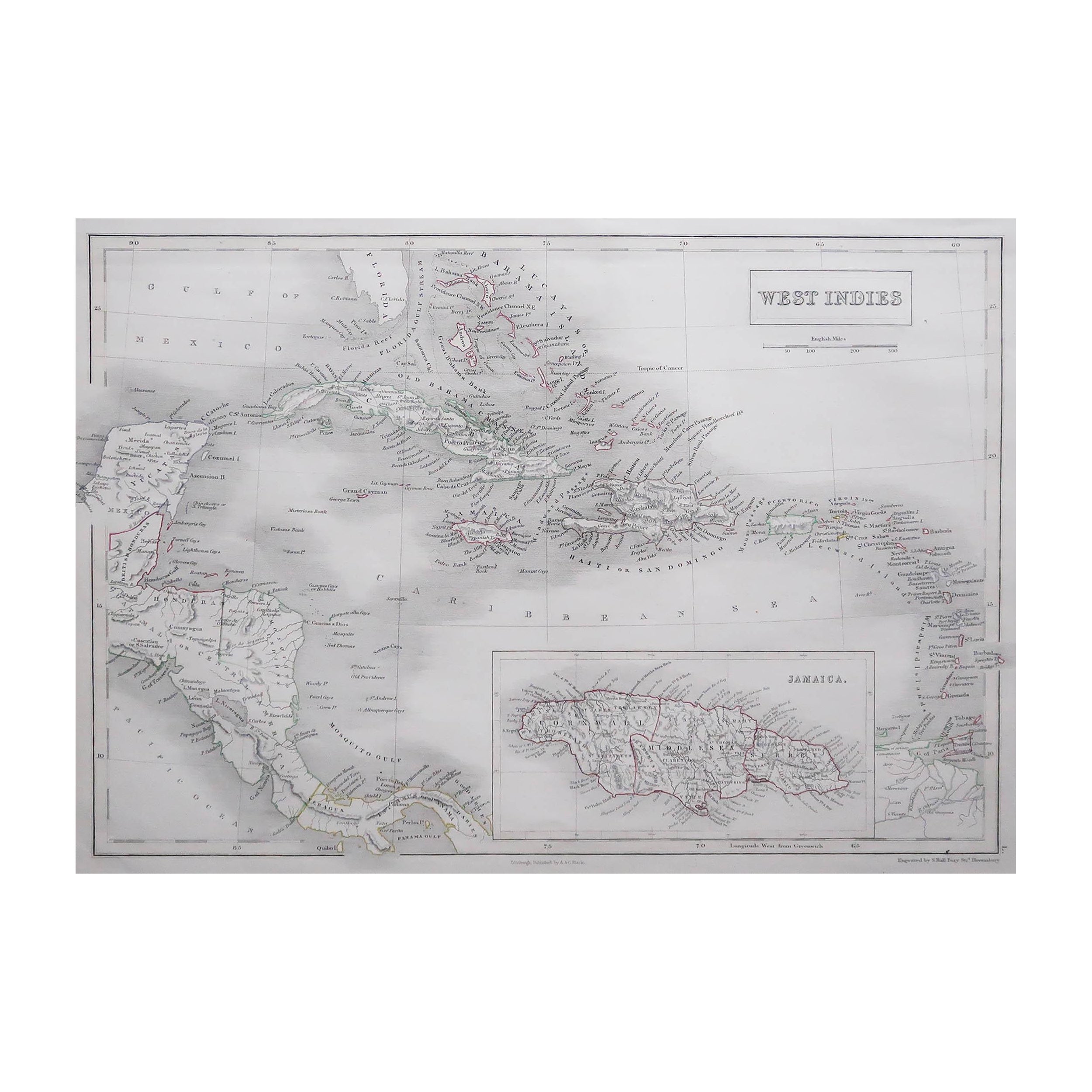
Antique Map of Grenada, West Indies, 1758
About the Item
- Dimensions:Height: 9.85 in (25 cm)Width: 7.09 in (18 cm)Depth: 0.01 in (0.2 mm)
- Materials and Techniques:Paper,Engraved
- Period:1750-1759
- Date of Manufacture:1758
- Condition:Good condition. Top right corner creased, touching the plate. One dirt spot on the right, middle and a few more minor spots due to age and handling. Please, study the image carefully.
- Seller Location:Langweer, NL
- Reference Number:Seller: BG-13618-351stDibs: LU3054337605902
About the Seller
5.0
Platinum Seller
These expertly vetted sellers are 1stDibs' most experienced sellers and are rated highest by our customers.
Established in 2009
1stDibs seller since 2017
1,947 sales on 1stDibs
More From This SellerView All
- Original Engraved Map of Saint Lucia in the West Indies by Bellin, 1758Located in Langweer, NLThe "Carte de L’Isle de Sainte Lucie" by Jacques Nicolas Bellin, a prominent figure as the Royal Hydrographer and engineer of the French Navy, is a remarkable antique map showcasing ...Category
Antique 1750s Maps
MaterialsPaper
- Antique Map of North America Including the West IndiesLocated in Langweer, NLOriginal antique map titled 'Nord-America'. Old map of North America and the West Indies. Also showing British Overseas Territories and Hudson Bay. This map originates from Stiel...Category
Antique Mid-19th Century Maps
MaterialsPaper
 $509 Sale Price20% Off
 - Antique Map of Central America and the West Indies, 1882Located in Langweer, NLAntique map titled 'West India Islands and Central America'. Old map of Central America and the West Indies. This map originates from 'The Royal Atlas of Modern Geography, Exhibiting...Category
Antique 19th Century Maps
MaterialsPaper
- Original Antique Map of the West Indies by J. Arrowsmith, 1842Located in Langweer, NLTitle: "J. Arrowsmith's 19th Century Map of the West Indies" This original antique map, crafted by J. Arrowsmith, details the West Indies with a focus on the Caribbean Sea and its s...Category
Antique Early 19th Century Maps
MaterialsPaper
- Antique Map of the West Indies in Full Color, 1922Located in Langweer, NLAntique map titled 'The West Indies.' A map of the West Indies, the Carribean region. This includes the Greater Antilles (Jamaica, Haiti, Puerto Rico and Cuba) and the Lesser Antille...Category
20th Century Maps
MaterialsPaper
- Antique Map of the West Indies and Ambon in Indonesia, 1900Located in Langweer, NLTwo maps on one sheet titled 'De West-Indische Eilanden (Nederlandsch Gedeelte)' and 'Ambon, Leasi-Eilanden en Banda-Eilanden'. Old map of the Dutch West Indies and Ambon Island, Ind...Category
20th Century Maps
MaterialsPaper
 $123 Sale Price20% Off

You May Also Like
- Seminal guide to the East and West Indies, with 42 coloured maps and platesBy Jan Huygen van LinschotenLocated in ZWIJNDRECHT, NLSeminal guide to the East and West Indies, with 42 double-page and folding plates, including 6 maps, all engravings beautifully coloured by a contemporary hand LINSCHOTEN, Jan Huygh...Category
Antique Early 17th Century Dutch Dutch Colonial Books
MaterialsPaper

- Antique Lithography Map, West Africa, English, Framed, Cartography, VictorianLocated in Hele, Devon, GBThis is an antique lithography map of Western Africa. An English, framed atlas engraving of cartographic interest by John Rapkin, dating to the early Victorian period and later, circ...Category
Antique Mid-19th Century British Early Victorian Maps
MaterialsWood
- Gold Leaf Foil Pictorial Plan Map of the West Country of England Antique StyleLocated in GBWe are delighted to offer for sale this lovely Antique style pictorial plan map of the West Country of England etched in gold leaf foil This is a very interesting and decorative p...Category
20th Century English Adam Style Maps
MaterialsGold Leaf
- Midcentury Sterling Silver West Indies Cricket Control Board Presentation TrayBy Barker Ellis Silver Co.Located in Hamilton, OntarioThis sterling silver footed presentation tray was made by the well-known English maker, Barker Ellis in circa 1967 in an Edwardian style. The tray is...Category
Mid-20th Century English Edwardian Sports Equipment and Memorabilia
MaterialsSterling Silver
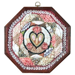
- Sailor's Valentine with Heart Design, Barbados, West Indies- Large SizeLocated in Downingtown, PAWest Indian Sailor's Valentine, Circa 1880 The large single sailor's valentine is composed from a variety of shells in concentric and geometric patterns, centred with a heart motif, surrounded by three flowers; within an octagonal stained wood frame. Dimensions: 13.86 inches wide x 13.82 inches (35.2cm wide, 35.1cm high) THE SAILOR'S VALENTINE A sailor's valentine is made of one, or, more often, a hinged pair of octagonal wooden display cases lined with fabric. Small shells, seeds, or other materials are glued to the fabric, usually forming a colorful design. The name "sailor's valentine" comes from the fact that there is usually a sentimental phrase, such as "Forget Me Not," "With Love," or other sayings that we use on Valentine's Day. The shape is thought to come from old compass...Category
Antique 1880s Bajan Victorian Paintings
MaterialsShell
- Cricket Print, England v. West Indies at the Oval, by Arthur WeaverBy Arthur WeaverLocated in Oxfordshire, GB1990's Arthur Weaver Oval Cricket Ground Print, England v West Indies. A colourful cricket lithograph signed by the artist, Arthur Weaver, of the 'Final Test' at The Oval Cricket Gr...Category
1990s English Sporting Art Sports Equipment and Memorabilia
MaterialsPaper


Recently Viewed
View AllMore Ways To Browse
Scottish Antique Historical
Winkler Prins
A Plan City And Castle Of Batavia
Very Large Map
Ree Brown
Old Nautical Maps
John Speed Isle Of Wight Maps
Malacca Strait Map
Cheshire Map
Victor Levasseur On Sale
Ecuador Antique Map
Guyana Antique Map
Wisconsin Map
Antique Map Dordogne
Antique Maps Of Puerto Rico
Berkshire Antique Map
La Syrie Antique
Warwickshire Antique Map