Items Similar to Original Antique Map of the West Indies by J. Arrowsmith, 1842


Want more images or videos?
Request additional images or videos from the seller
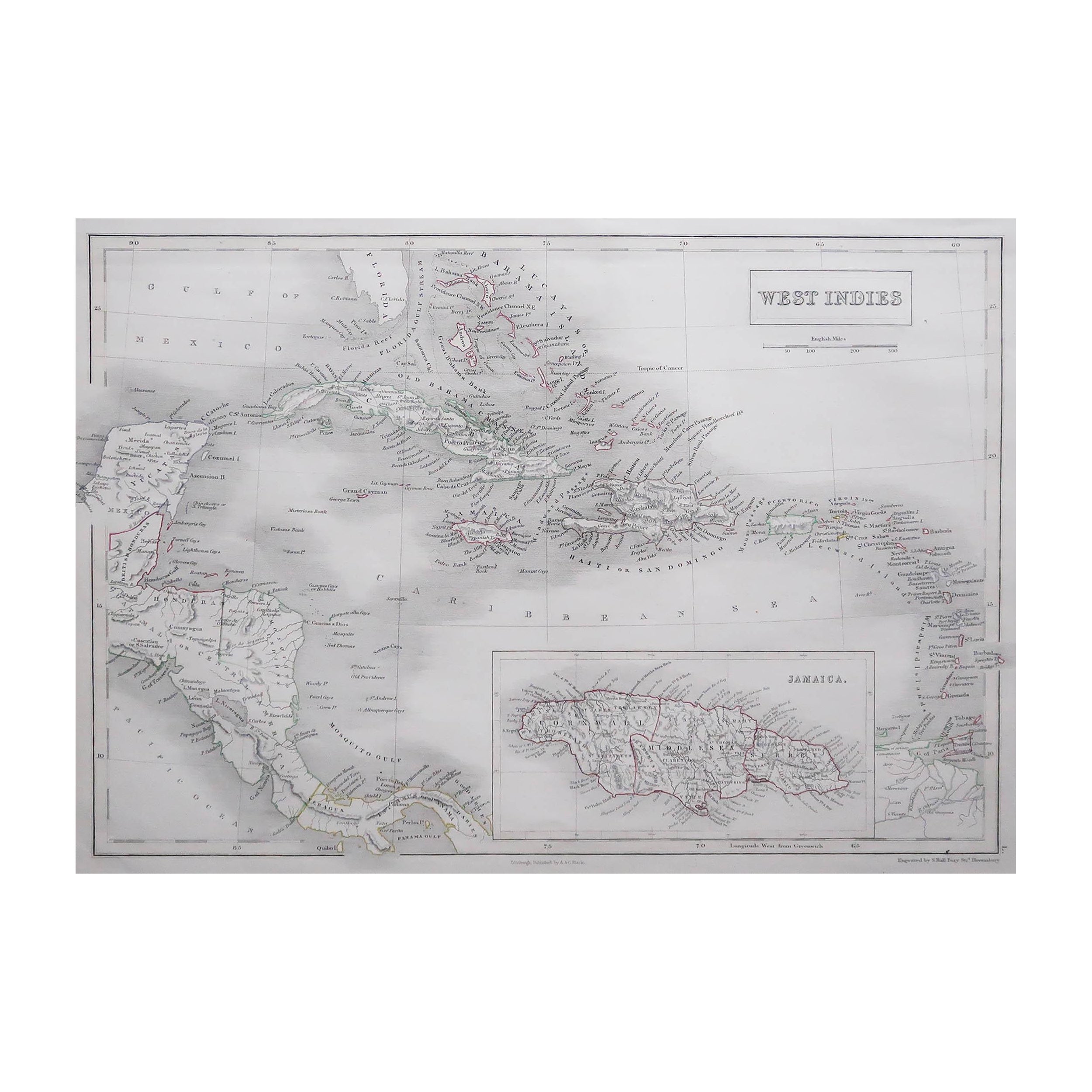
Original Antique Map of the West Indies by J. Arrowsmith, 1842
About the Item
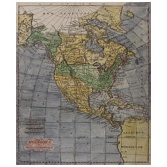
Title: "J. Arrowsmith's 19th Century Map of the West Indies"
This original antique map, crafted by J. Arrowsmith, details the West Indies with a focus on the Caribbean Sea and its surrounding landmasses, including Florida, the Gulf of Mexico, and the northern coastline of South America.
The map, characterized by its fine engraving and delicate hand coloring, illustrates the various islands and key ports of the region, all meticulously labeled. It provides a historical perspective on the geography and colonial interests of the time. The subtlety of the color palette and the precision of the cartographic details not only make it a navigational piece but also a work of art. Notable for its comprehensive depiction of the Caribbean islands, this map is a testament to the skill and craftsmanship of 19th-century cartography, embodying both the scientific knowledge and the aesthetic sensibilities of the era.
The map depicts a large number of islands in the West Indies, which includes the Caribbean islands. Some of the primary landmasses and island groups visible include:
1. The large island at the left is part of Florida and the adjacent Florida Keys.
2. Cuba is the large island below Florida, to the left.
3. The Bahamas are to the northeast of Cuba.
4. Hispaniola, divided into Haiti (western portion) and the Dominican Republic (eastern portion), is to the east of Cuba.
5. Jamaica is located south of Cuba.
6. Puerto Rico is to the east of Hispaniola.
7. The Lesser Antilles, including both the Leeward Islands and the Windward Islands, arc towards the southeast from Puerto Rico.
8. The northern coast of South America, including parts of Colombia and Venezuela, is at the bottom right.
These islands are part of a larger archipelago in the Caribbean Sea and are significant both geographically and historically. The map appears to detail the various smaller islands and cays that make up this region, each with its own topographical features and colonial affiliations as of the date of the map's creation.
J. Arrowsmith refers to John Arrowsmith, a renowned British cartographer and member of the Arrowsmith family of geographers. He was born in 1790 and became one of the most respected mapmakers of the 19th century. John Arrowsmith was known for his meticulous attention to detail and his commitment to updating maps with the latest geographical knowledge.
He established his own business in London in the 1830s, where he published a series of maps and charts which were highly praised for their accuracy and craftsmanship. Arrowsmith's maps covered all parts of the world and were used extensively for exploration, navigation, and colonization purposes. He was awarded the Gold Medal of the Royal Geographical Society of which he was a member.
John Arrowsmith's uncle, Aaron Arrowsmith, was also a distinguished cartographer, and his work set a high standard which John continued. The Arrowsmiths' maps were distinctive for their clarity and lack of unnecessary decoration, focusing instead on providing reliable information for the map's users.
John Arrowsmith's contribution to cartography was significant during a period when geographical knowledge was rapidly expanding due to exploration, particularly in the Australian continent and the Canadian Arctic. His maps remain important historical documents and collectibles for their beauty and the wealth of information they provide.
The map by J. Arrowsmith appears to be in relatively good condition for its age. The paper has retained its structure without any noticeable large tears or areas of loss. There is a natural aged tone to the paper, which is common for documents of this vintage, and it adds to its antique character.
The colors on the map, though likely faded over time, still seem to have some vibrancy, suggesting the map has been reasonably well-preserved, possibly stored away from direct sunlight or in a climate-controlled environment to prevent significant deterioration.
There are signs of folding or creasing, as indicated by the vertical and horizontal lines across the map, which is typical for maps that were designed to be folded for use or inserted into atlases. The edges show some wear, and there might be minor fraying or chipping, which is also consistent with the handling of maps over many years.
Overall, the map's legibility is maintained, with text and cartographic details remaining clear, indicating that it has been cared for. For collectors or those interested in historical maps, its condition would likely be deemed satisfactory, especially given that such signs of aging are expected and often contribute to the map's historical value.
- Dimensions:Height: 20.87 in (53 cm)Width: 27.17 in (69 cm)Depth: 0 in (0.02 mm)
- Materials and Techniques:
- Period:
- Date of Manufacture:1842
- Condition:Some folds and creases, which is typical for maps that were designed to be folded for use or inserted into atlases. The edges show some wear, and creases but once framed a beautiful piece.
- Seller Location:Langweer, NL
- Reference Number:Seller: BG-13618-51stDibs: LU3054337731372
About the Seller
5.0
Platinum Seller
These expertly vetted sellers are 1stDibs' most experienced sellers and are rated highest by our customers.
Established in 2009
1stDibs seller since 2017
1,950 sales on 1stDibs
Typical response time: <1 hour
- ShippingRetrieving quote...Ships From: Langweer, Netherlands
- Return PolicyA return for this item may be initiated within 14 days of delivery.
Auctions on 1stDibs
Our timed auctions are an opportunity to bid on extraordinary design. We do not charge a Buyer's Premium and shipping is facilitated by 1stDibs and/or the seller. Plus, all auction purchases are covered by our comprehensive Buyer Protection. Learn More
More From This SellerView All
- Antique Map of the West Indies by Wyld '1845'Located in Langweer, NLAntique map titled 'Map of the West India Islands'. Original antique map of the West Indies, including Cuba, the Bahamas, the Antilles a...Category
Antique Mid-19th Century Maps
MaterialsPaper
- Original Antique Map of the Island of Dominica in the West Indies, 1794Located in Langweer, NLMAP OF THE ISLAND OF DOMINICA for the History of the West Indies, by Bryan Edwards. Esq. Dominica, an island renowned for its lucrative exports of sugar, cocoa, and coffee, operated...Category
Antique 1790s Maps
MaterialsPaper
- Antique Map of North America Including the West IndiesLocated in Langweer, NLOriginal antique map titled 'Nord-America'. Old map of North America and the West Indies. Also showing British Overseas Territories and Hudson Bay. This map originates from Stiel...Category
Antique Mid-19th Century Maps
MaterialsPaper
- Original Antique Map of Martinique Island In The West Indies by Bonne, circa1780Located in Langweer, NLAntique map titled 'Carte de l'Isle de la Martinique Colonie Francoise dans les Isles Antilles'. Detailed map of the French Island of Martinique. Many towns and harbours, anchor pl...Category
Antique 18th Century Maps
MaterialsPaper
- Antique Map of the West Indies in Full Color, 1922Located in Langweer, NLAntique map titled 'The West Indies.' A map of the West Indies, the Carribean region. This includes the Greater Antilles (Jamaica, Haiti, Puerto Rico and Cuba) and the Lesser Antille...Category
20th Century Maps
MaterialsPaper
- Antique Map of Central America and the West Indies, 1882Located in Langweer, NLAntique map titled 'West India Islands and Central America'. Old map of Central America and the West Indies. This map originates from 'The Royal Atlas of Modern Geography, Exhibiting...Category
Antique 19th Century Maps
MaterialsPaper


You May Also Like
- 1842 Wall Map of the United States by J. H. Young, Published by S. A. MitchellLocated in Colorado Springs, COPresented is an 1842 hanging “Map of the United States,” engraved by J. H. Young and published by Samuel Augustus Mitchell, Philadelphia. This is a beautiful example of the rare 1842...Category
Antique 1840s American Maps
MaterialsPaper
- Seminal guide to the East and West Indies, with 42 coloured maps and platesBy Jan Huygen van LinschotenLocated in ZWIJNDRECHT, NLSeminal guide to the East and West Indies, with 42 double-page and folding plates, including 6 maps, all engravings beautifully coloured by a contemporary hand LINSCHOTEN, Jan Huygh...Category
Antique Early 17th Century Dutch Dutch Colonial Books
MaterialsPaper
- Cricket Print, England v. West Indies at the Oval, by Arthur WeaverBy Arthur WeaverLocated in Oxfordshire, GB1990's Arthur Weaver Oval Cricket Ground Print, England v West Indies. A colourful cricket lithograph signed by the artist, Arthur Weaver, of the 'Final Test' at The Oval Cricket Gr...Category
1990s English Sporting Art Sports Equipment and Memorabilia
MaterialsPaper
- Early 19th Century Hand Coloured Map of North America by Aaron ArrowsmithBy Aaron ArrowsmithLocated in Hamilton, OntarioHand coloured map in French by English cartographer Aaron Arrowsmith (1750–1823) titled "Amerique Septentionale" (North America). Map size: 9.5" x 8" Mat size: 20.5" x 14.25".Category
Antique Early 19th Century English Maps
MaterialsPaper
- Gold Leaf Foil Pictorial Plan Map of the West Country of England Antique StyleLocated in GBWe are delighted to offer for sale this lovely Antique style pictorial plan map of the West Country of England etched in gold leaf foil This is a very interesting and decorative p...Category
20th Century English Adam Style Maps
MaterialsGold Leaf
- 1861 Topographical Map of the District of Columbia, by Boschke, Antique MapLocated in Colorado Springs, COPresented is an original map of Albert Boschke's extremely sought-after "Topographical Map of the District of Columbia Surveyed in the Years 1856 ...Category
Antique 1860s American Historical Memorabilia
MaterialsPaper


Recently Viewed
View AllMore Ways To Browse
18th Century Revolutionary
Wenceslas Hollar
Bad Bentheim
English County Maps By Blaeu
Von Meer
Minature Map
Anguilla Map
James Calvert Smith
Montenegro Antique Map
Mozambique Antique Map
Nottinghamshire Antique Map
Panama Antique Map
Wisconsin Map
Antique Map Sydney
Historical Balkan Map
Map Of Majorca
Yorkshire Ridings Map
Antique Map Dordogne