Items Similar to Original Antique Map of the Island of Dominica in the West Indies, 1794


Want more images or videos?
Request additional images or videos from the seller
Original Antique Map of the Island of Dominica in the West Indies, 1794
About the Item
MAP OF THE ISLAND OF DOMINICA for the History of the West Indies, by Bryan Edwards. Esq.
Dominica, an island renowned for its lucrative exports of sugar, cocoa, and coffee, operated on a thriving but deeply troubling slave-based economy during the 17th to 19th centuries. The continuous struggle for dominance between the French and British resulted in the island changing ownership at least four times during this period. This historical tug-of-war is reflected in the map's place names, which bear witness to both French and English influences.
Published in London in 1794 by John Stockdale, this map was a component of Bryan Edwards’ “History of the West Indies.” The publication chronicled the complex historical narratives and socio-economic dynamics of the Caribbean region. Remarkably, the very year following the map's issuance, the French made another unsuccessful attempt to invade the island, further cementing Dominica's place as a strategic and contested territory in the Caribbean theater of colonial powers. This map stands as both a historical artifact and a representation of the island's significance amid the enduring conflicts between European nations vying for control and economic supremacy in the West Indies.
- Dimensions:Height: 10.44 in (26.5 cm)Width: 7.88 in (20 cm)Depth: 0 in (0.02 mm)
- Materials and Techniques:Paper,Engraved
- Period:1790-1799
- Date of Manufacture:1794
- Condition:This map is in very good condition and attractively colored. Blanco reverse. Study the image carefully.
- Seller Location:Langweer, NL
- Reference Number:
About the Seller
5.0
Platinum Seller
These expertly vetted sellers are 1stDibs' most experienced sellers and are rated highest by our customers.
Established in 2009
1stDibs seller since 2017
1,950 sales on 1stDibs
Typical response time: <1 hour
- ShippingRetrieving quote...Ships From: Langweer, Netherlands
- Return PolicyA return for this item may be initiated within 14 days of delivery.
More From This SellerView All
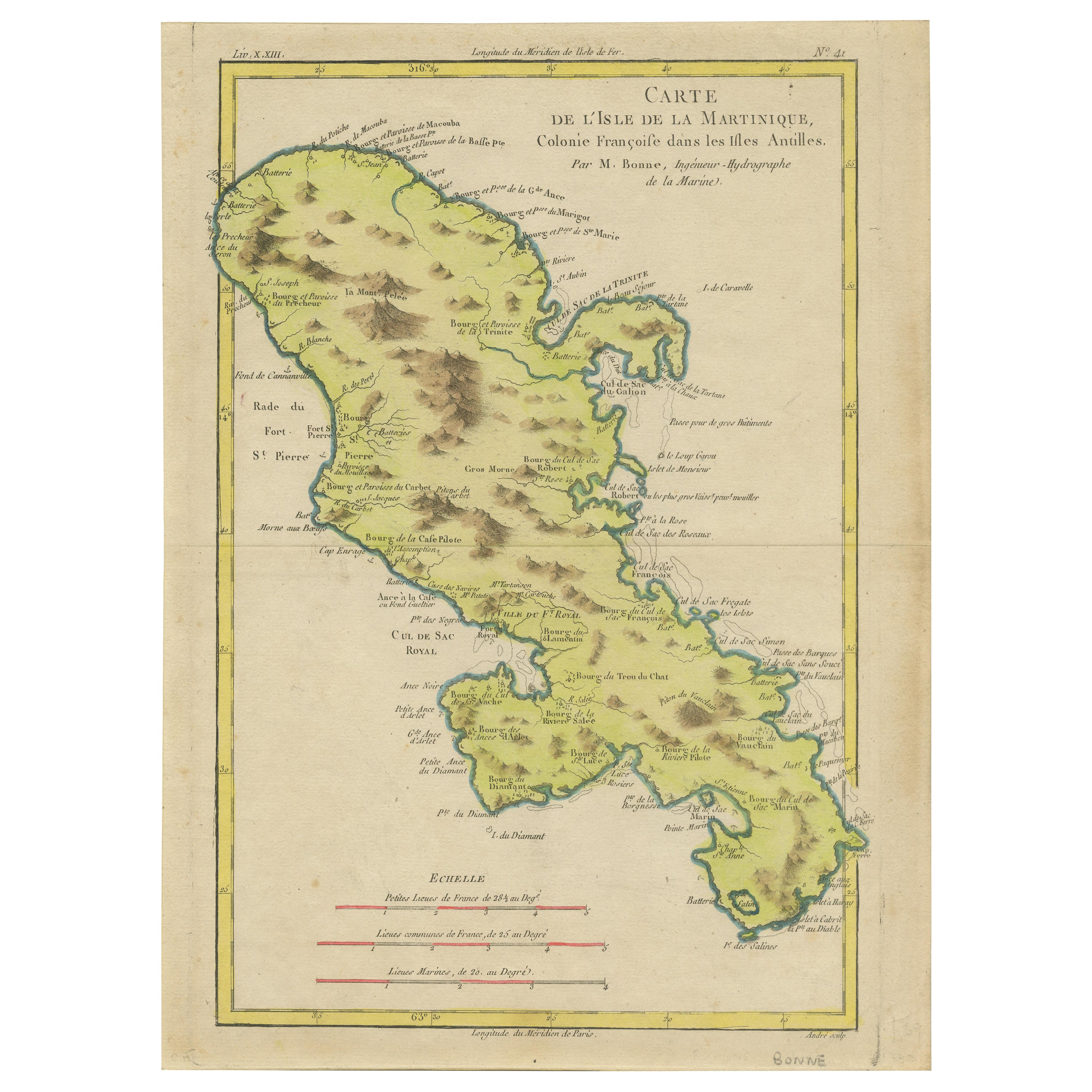
- Original Antique Map of Martinique Island In The West Indies by Bonne, circa1780Located in Langweer, NLAntique map titled 'Carte de l'Isle de la Martinique Colonie Francoise dans les Isles Antilles'. Detailed map of the French Island of Martinique. Many towns and harbours, anchor pl...Category
Antique 18th Century Maps
MaterialsPaper
- Original Antique Map of the West Indies by J. Arrowsmith, 1842Located in Langweer, NLTitle: "J. Arrowsmith's 19th Century Map of the West Indies" This original antique map, crafted by J. Arrowsmith, details the West Indies with a focus on the Caribbean Sea and its s...Category
Antique Early 19th Century Maps
MaterialsPaper
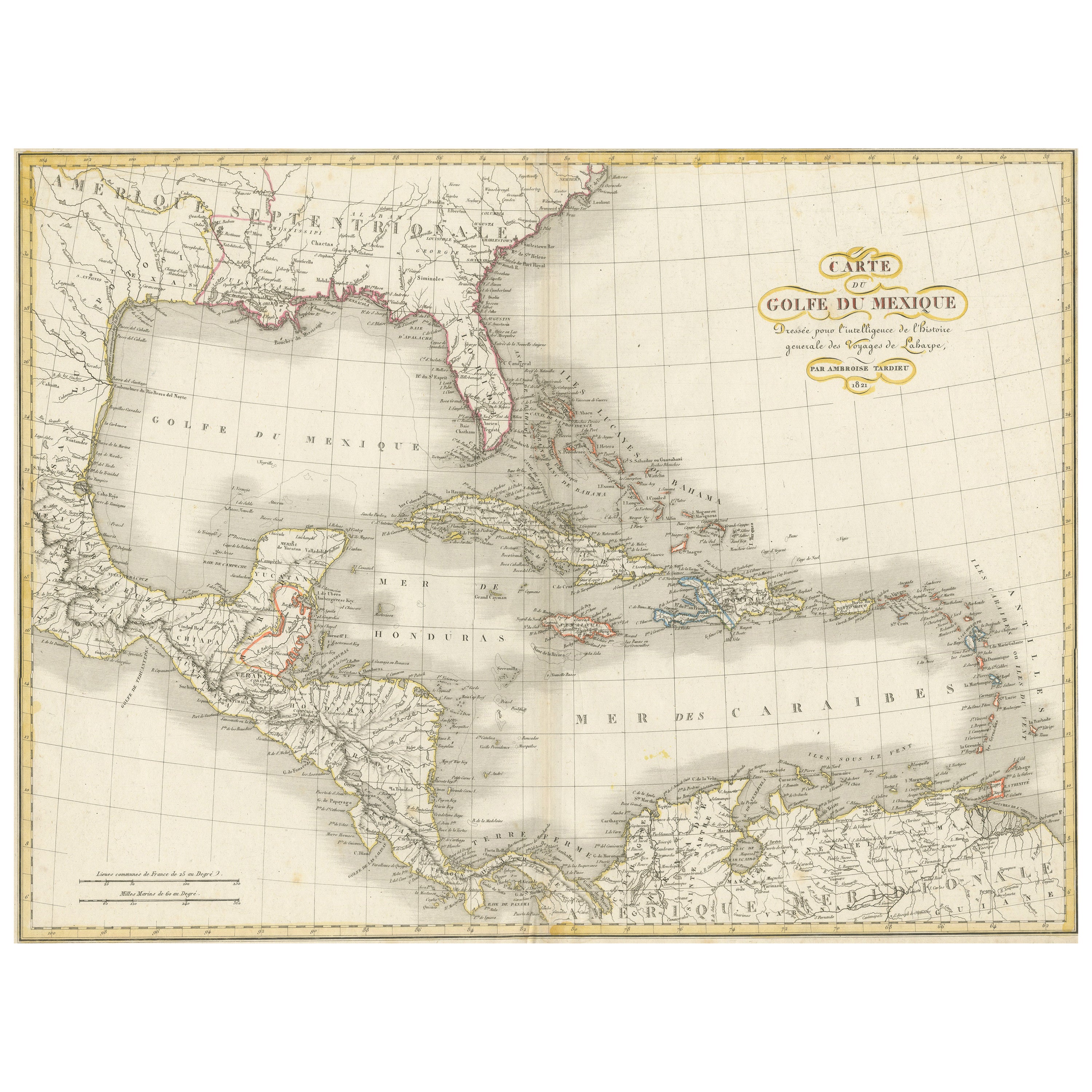
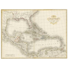
- Antique Map of the Gulf of Mexico and all the islands of the West IndiesLocated in Langweer, NLAntique map titled 'Carte du Golfe du Mexique'. This uncommon map depicts the Gulf of Mexico and all the islands of the West Indies. It also includes ni...Category
Antique Early 19th Century Maps
MaterialsPaper
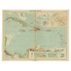
- Antique Map of the West Indies in Full Color, 1922Located in Langweer, NLAntique map titled 'The West Indies.' A map of the West Indies, the Carribean region. This includes the Greater Antilles (Jamaica, Haiti, Puerto Rico and Cuba) and the Lesser Antille...Category
20th Century Maps
MaterialsPaper
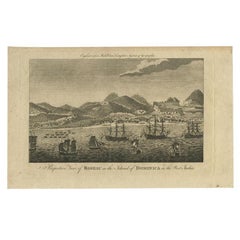
- Antique Print of Roseau, Place in Dominica Island in the West-Indies, 1779Located in Langweer, NLAntique print titled 'Perspective View of Roseau in the Island of Dominica in the West Indies.' View of Roseau with ships on the foreground Dominica. Originates from 'Middleton's New...Category
Antique 18th Century Prints
MaterialsPaper
- Antique Map of North America Including the West IndiesLocated in Langweer, NLOriginal antique map titled 'Nord-America'. Old map of North America and the West Indies. Also showing British Overseas Territories and Hudson Bay. This map originates from Stiel...Category
Antique Mid-19th Century Maps
MaterialsPaper

You May Also Like
- Large Original Antique Map of The West Indies by Sidney Hall, 1847Located in St Annes, LancashireGreat map of The West Indies Drawn and engraved by Sidney Hall Steel engraving Original colour outline Published by A & C Black. 1847 Unframed Free shipping.Category
Antique 1840s Scottish Maps
MaterialsPaper
- Large Original Antique Map of Rhode Island, USA, C.1900Located in St Annes, LancashireFabulous map of Rhode Island Original color Engraved and printed by the George F. Cram Company, Indianapolis. Published, C.1900 Unframed Free ...Category
Antique 1890s American Maps
MaterialsPaper
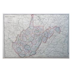
- Large Original Antique Map of West Virginia, USA, C.1900Located in St Annes, LancashireFabulous map of West Virginia Original color Engraved and printed by the George F. Cram Company, Indianapolis. Published, C.1900 Unframed Free shipping.Category
Antique 1890s American Maps
MaterialsPaper
- Large Original Vintage Map of The Pacific Islands Including HawaiiLocated in St Annes, LancashireGreat map of The Pacific Islands Unframed Original color By John Bartholomew and Co. Edinburgh Geographical Institute Published, circa 1...Category
Vintage 1920s British Maps
MaterialsPaper
- Seminal guide to the East and West Indies, with 42 coloured maps and platesBy Jan Huygen van LinschotenLocated in ZWIJNDRECHT, NLSeminal guide to the East and West Indies, with 42 double-page and folding plates, including 6 maps, all engravings beautifully coloured by a contemporary hand LINSCHOTEN, Jan Huygh...Category
Antique Early 17th Century Dutch Dutch Colonial Books
MaterialsPaper
- Original Antique Decorative Map of South America-West Coast, Fullarton, C.1870Located in St Annes, LancashireGreat map of Chili, Peru and part of Bolivia Wonderful figural border From the celebrated Royal Illustrated Atlas Lithograph. Original color. Published by Fullarton, Edi...Category
Antique 1870s Scottish Maps
MaterialsPaper


Recently Viewed
View AllMore Ways To Browse
Antique Compass France
John Speed Isle Of Wight Maps
Compass France
Isle Of Wight Maps
Old French Map
Ancient Map Of Israel
John Tallis Map
Austria Hungary Map
Kiribati Islands Map
Map Of Kiribati Islands
Montana Maps
Oman Map
Palliser Furniture
Barbados Map
Map Of Barbados
Britton And Rey Lithograph
Christoph Weigel On Sale
Clivia Ducatus Et Ravestein Dominium