Items Similar to Original Antique Chart of the Santa Cruz Islands, 1774


Want more images or videos?
Request additional images or videos from the seller
1 of 5
Original Antique Chart of the Santa Cruz Islands, 1774
About the Item
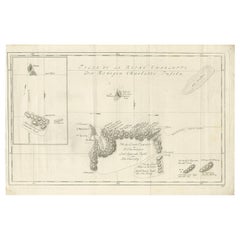
Antique print titled 'Isles de la Reine Charlotte (..)'.
A detailed chart of the Santa Cruz islands, to the north of the New Hebrides, with Carteret's track in "Swallow"; including an inset chart of Carteret and Gower Islands. Relief is shown by hachuring; vegetation is marked by small tree-symbols, revealing that the tops of the mountains were wooded. Along the explored coast of the "Isle Du Lord Egmont", palm trees and huts have been drawn, perhaps marking native settlements. A particularly detailed volcano spewing smoke is shown in profile to the North of this island. Prevailing winds are marked with arrows. Originates from 'Geschichte der See-Reisen und Entdeckungen im Süd-Meer welche auf Befehl Sr. Großbrittanischen Majestät unternommen, und von Commodore Byron, Capitain Wallis, Capitain Carteret und Capitain Coockim Dolphin, der Swallow, und dem Endeavour nach einander ausgeführt worden sind (..)'.
Artists and Engravers: Published by Haude & Spener, Berlin.
Condition: Very good, general age-related toning. Please study image carefully.
- Dimensions:Height: 10.44 in (26.5 cm)Width: 16.15 in (41 cm)Depth: 0 in (0.02 mm)
- Materials and Techniques:
- Period:1770-1779
- Date of Manufacture:1774
- Condition:
- Seller Location:Langweer, NL
- Reference Number:
About the Seller
5.0
Platinum Seller
These expertly vetted sellers are 1stDibs' most experienced sellers and are rated highest by our customers.
Established in 2009
1stDibs seller since 2017
1,947 sales on 1stDibs
Typical response time: <1 hour
- ShippingRetrieving quote...Ships From: Langweer, Netherlands
- Return PolicyA return for this item may be initiated within 14 days of delivery.
More From This SellerView All
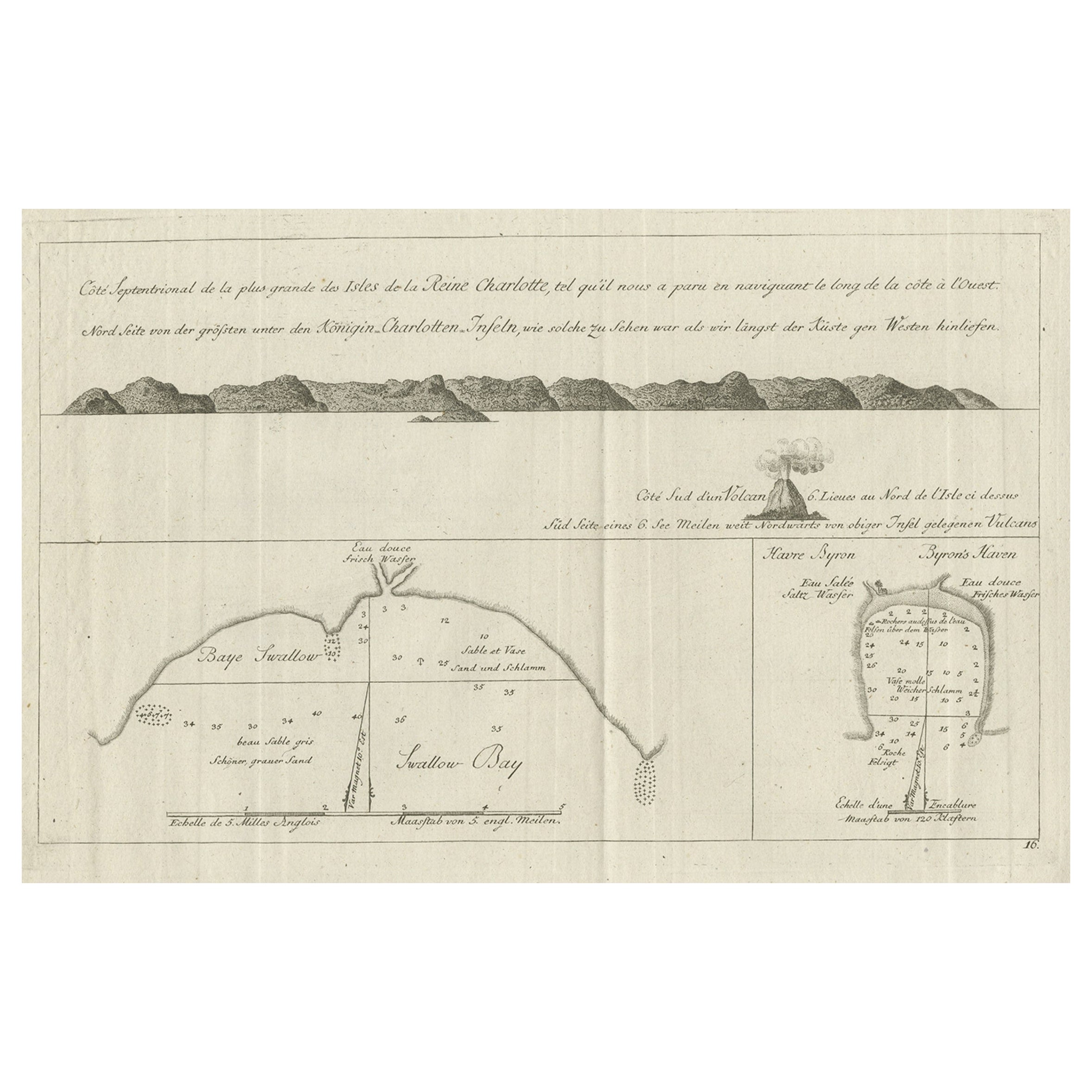
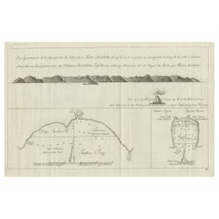
- Old View of the Queen Charlotte's Islands 'Santa Cruz Islands, Solomon', 1774Located in Langweer, NLAntique map titled 'Cote Septentrional de la plus grande des Isles de la Reine Charlotte (..)'. Map and coastal view of the islands within the Queen Charlotte's Islands (Santa Cruz Islands...Category
Antique 1770s Maps
MaterialsPaper
- Antique Map of the Santa Cruz Islands by Hawkesworth, 1774Located in Langweer, NLAntique print titled 'Isles de la Reine Charlotte (..)'. A detailed chart of the Santa Cruz islands, to the north of the New Hebrides, with Carteret'...Category
Antique 18th Century Maps
MaterialsPaper
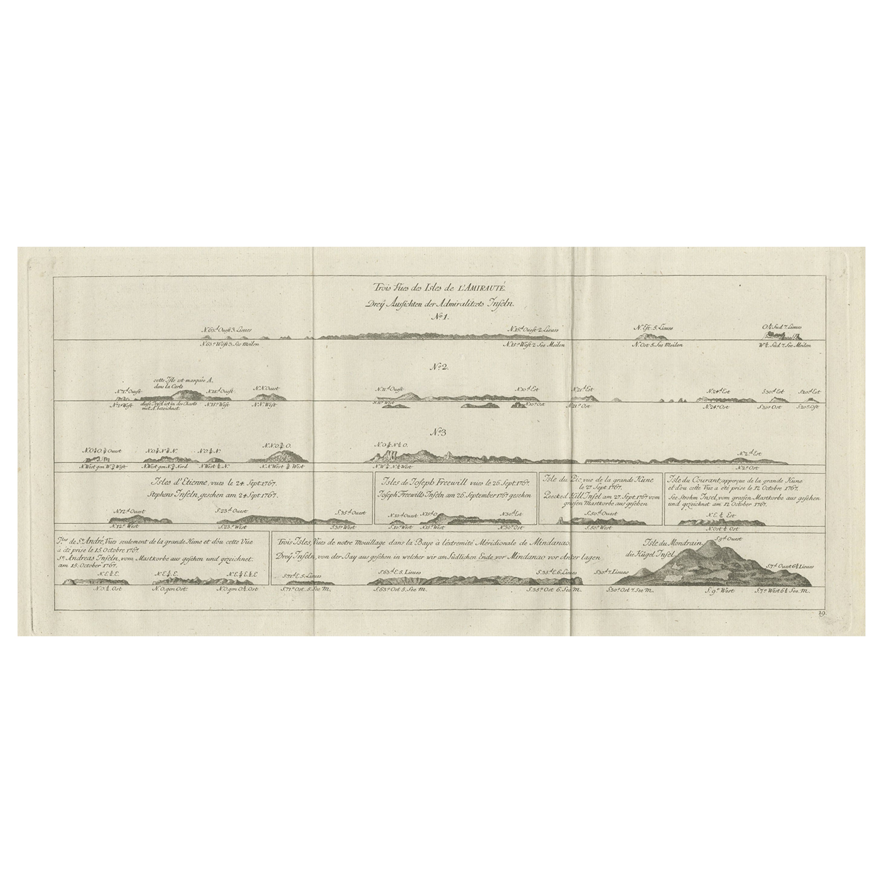
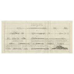
- Original Antique Engraving of the Admiralty Islands 'Bismarck Archipelago', 1774Located in Langweer, NLAntique print titled 'Trois Vues des Isles de l'Amirauté (..)'. Several coastal views of the Admiralty Islands. Originates from 'Geschichte der See-Reisen und Entdeckungen im Süd-Mee...Category
Antique 18th Century Prints
MaterialsPaper
- Antique Chart of the Banda Islands or The Spice Islands, Indonesia, 1726Located in Langweer, NLAntique map titled 'Nieuwe Caart der Eylanden van Banda'. Beautiful chart of the Banda Islands including Banda Api, Banda Neira, Banda Besar, Pulau Hatta (Rosengain), Pulau Ai an...Category
Antique 1720s Maps
MaterialsPaper
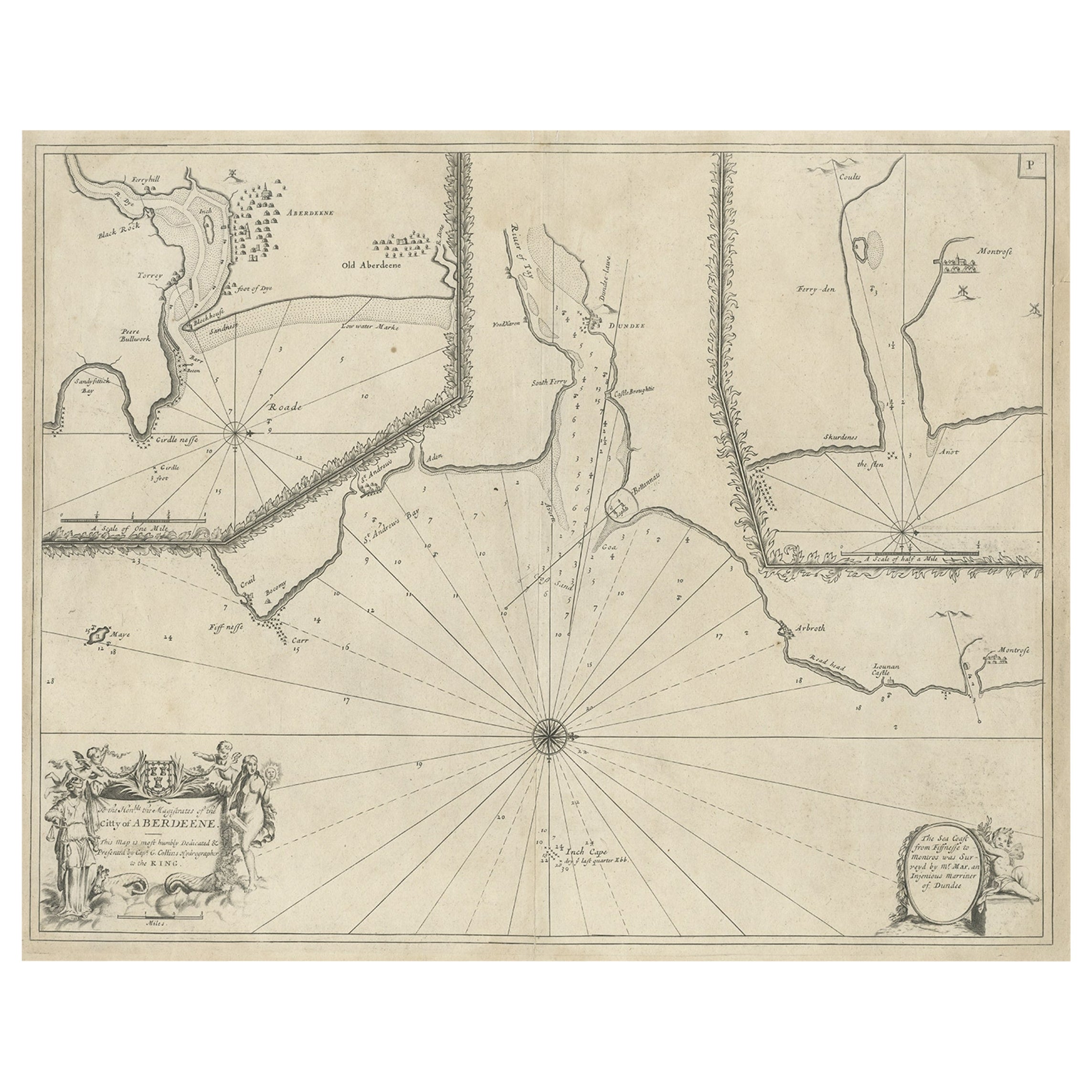
- Antique Chart of Dundee, Aberdeen and Montrose in Scotland, C.1774By Captain Greenvile CollinsLocated in Langweer, NLAntique map titled 'To the Honble the Magistrates of the Citty of Aberdeene'. Sea chart of Tay Estuary depictinging Dundee, with two further inset charts of Aberdeen and Montrose, wi...Category
Antique 18th Century Maps
MaterialsPaper
- Antique Sea Chart of the Shetland Islands, Scotland, ca.1745Located in Langweer, NLAntique map of Scotland titled 'Nieuwe Paskaard van Hitland met de daar omleggende eylanden na de nieuwe aftekening gemaakt by den Lofwaarden en onvermoeyden Hit en Zeeman Ian Bruyst...Category
Antique 1740s Maps
MaterialsPaper


You May Also Like
- Antique Anatomical Wall Chart Depicting the Human SkeletonLocated in Berghuelen, DEA rare 19th century anatomical wall chart depicting the human skeleton. On the sides On the sides are detailed description in German language. The wall...Category
Early 20th Century German Victorian Prints
MaterialsPaper
- Antique Foldable Anatomical Wall Chart Depicting Human MusculatureLocated in Berghuelen, DEAntique Foldable Anatomical Wall Chart Depicting Human Musculature The rare 19th century anatomical wall chart depicts the human musculature and inter...Category
Early 20th Century German Victorian Prints
MaterialsWood, Paper
- Original Antique Map of The Netherlands, Engraved by Barlow, Dated 1807Located in St Annes, LancashireGreat map of Netherlands Copper-plate engraving by Barlow Published by Brightly & Kinnersly, Bungay, Suffolk. Dated 1807 Unframed.Category
Antique Early 1800s English Maps
MaterialsPaper
- Original Antique Map of The Netherlands, Sherwood, Neely & Jones, Dated 1809Located in St Annes, LancashireGreat map of The Netherlands Copper-plate engraving by Cooper Published by Sherwood, Neely & Jones. Dated 1809 Unframed.Category
Antique Early 1800s English Maps
MaterialsPaper
- Anatomical Wall Chart Depicting the Human Lymphatic and Blood VesselsLocated in Berghuelen, DEA rare 19-carat anatomical wall chart depicting the human lymphatic and blood vessels. On the sides with detailed description in German language. Print...Category
Early 20th Century German Victorian Prints
MaterialsPaper
- Original Antique Map of Italy. C.1780Located in St Annes, LancashireGreat map of Italy Copper-plate engraving Published C.1780 Unframed.Category
Antique Early 1800s English Georgian Maps
MaterialsPaper


