Items Similar to Original Antique View of the City of Damietta, Egypt, 1774
Want more images or videos?
Request additional images or videos from the seller
Original Antique View of the City of Damietta, Egypt, 1774
About the Item
Antique print, titled: 'Prospect der Stadt Damiat.' - Tab VIII.
View of the city of Damietta, Egypt. From 'Reisebeschreibung von Arabien und anderen umliegenden Landern (1774-1778). Carsten Niebuhr (1733-1815) travelled extensively in Arabia, Persia, Palestine and Asia Minor, and became by his descriptions and maps and the richness of his observations the pioneer of a more profound knowledge of the Orient.
Artists and Engravers: Made by G. Haas after Baurenfeind. Author: Carsten Niebuhr.
- Dimensions:Height: 10.52 in (26.7 cm)Width: 16.54 in (42 cm)Depth: 0 in (0.02 mm)
- Materials and Techniques:
- Period:1770-1779
- Date of Manufacture:1774
- Condition:Repaired: A tear in the middle fold, reinforced on the rear. Original middle fold, as issued. A tear in the middle fold, reinforced on the rear. Some soiling in the margins. A stain in the lower margin (left and right of the middle fold).
- Seller Location:Langweer, NL
- Reference Number:
About the Seller
5.0
Platinum Seller
These expertly vetted sellers are 1stDibs' most experienced sellers and are rated highest by our customers.
Established in 2009
1stDibs seller since 2017
1,956 sales on 1stDibs
Typical response time: <1 hour
- ShippingRetrieving quote...Ships From: Langweer, Netherlands
- Return PolicyA return for this item may be initiated within 14 days of delivery.
More From This SellerView All
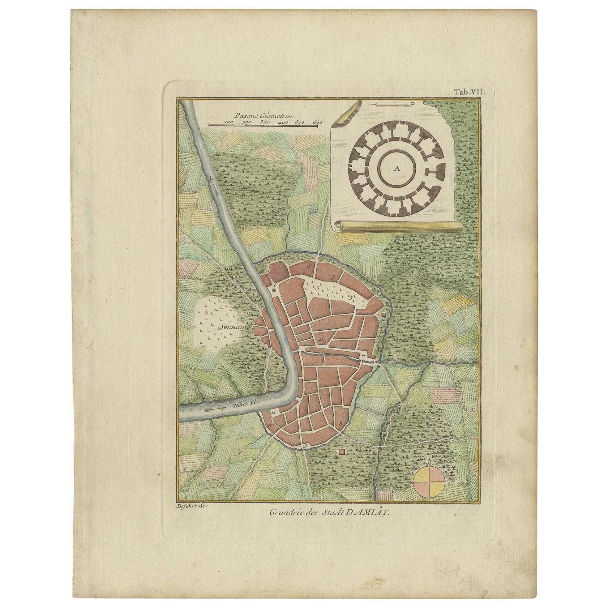
- Antique Plan of the City of Damietta Egypt by C. Niebuhr, 1774Located in Langweer, NLAntique print titled 'Grundris der Stadt Damiât'. This print originates from 'Reisebeschreibung nach Arabien und andern umliegenden Ländern' by C. Niebuhr, 1774.Category
Antique Late 18th Century Prints
MaterialsPaper
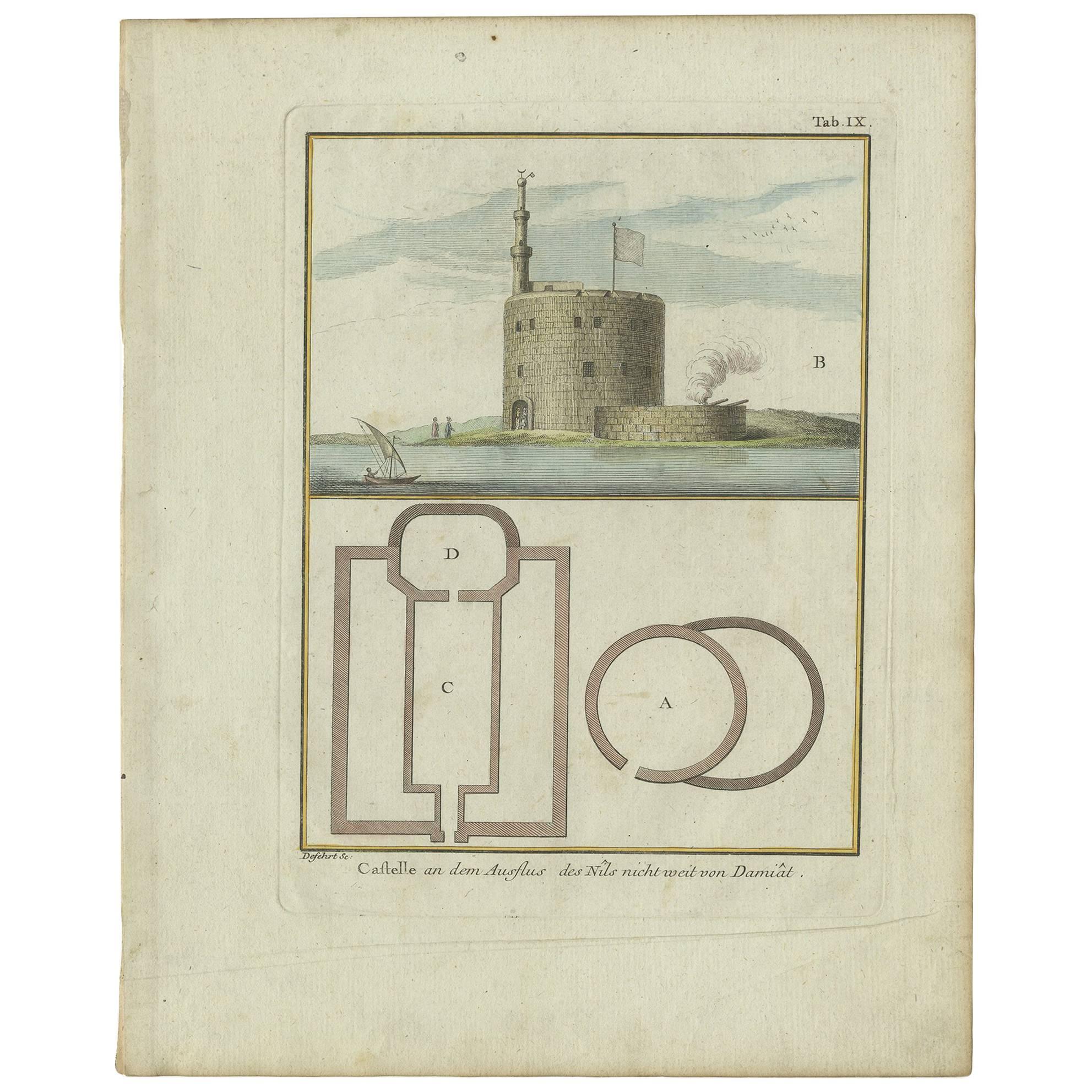
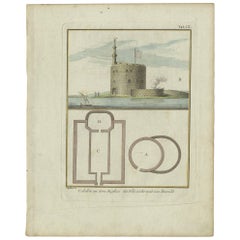
- Antique Print of the Fortress at the Nile 'Damietta, Egypt' by C. Niebuhr, 1774Located in Langweer, NLAntique print titled 'Castelle an dem Ausflus des Nîls nicht weit von Damiât'. Translated: 'Fort at the estuary of the Nile near Damietta, Egypt'. This print originates from 'Reisebe...Category
Antique Late 18th Century Maps
MaterialsPaper
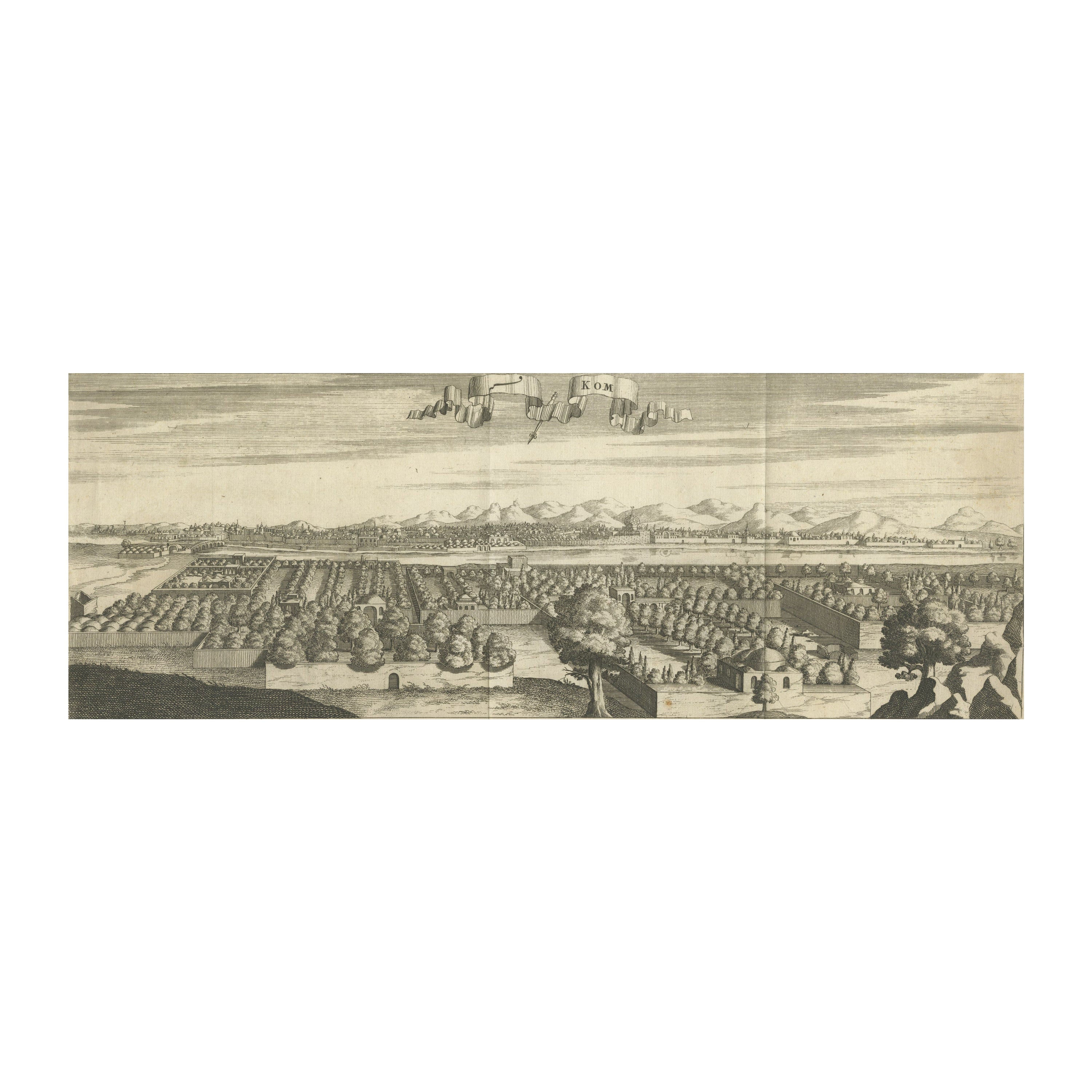
- Rare Engraving with a View of the City of Kom in EgyptLocated in Langweer, NLThis is an original antique print of the city of Kom in Egypt.Category
Antique Late 18th Century Prints
MaterialsPaper
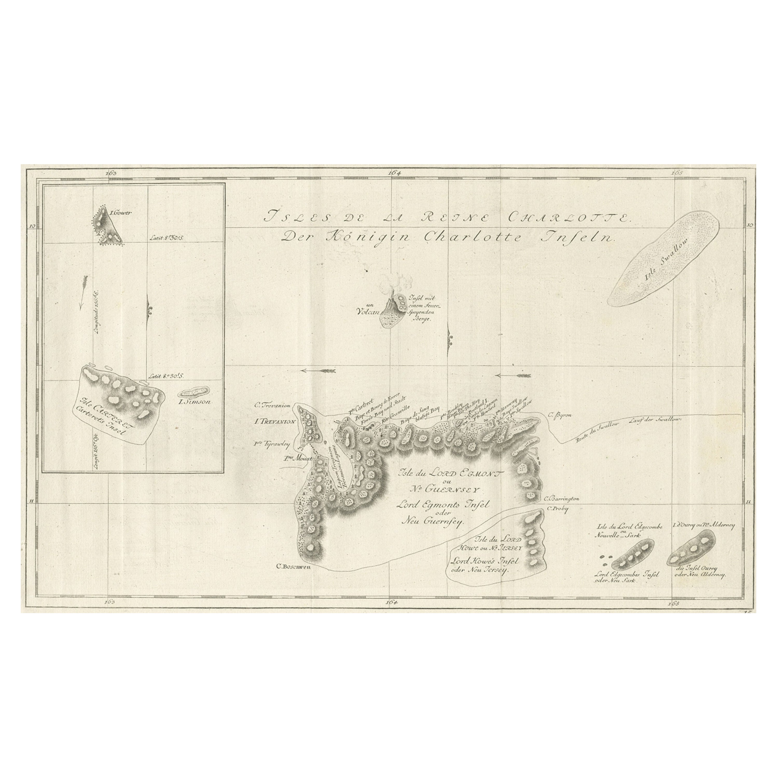
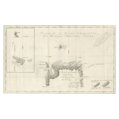
- Original Antique Chart of the Santa Cruz Islands, 1774Located in Langweer, NLAntique print titled 'Isles de la Reine Charlotte (..)'. A detailed chart of the Santa Cruz islands, to the north of the New Hebrides, with Carte...Category
Antique 1770s Maps
MaterialsPaper
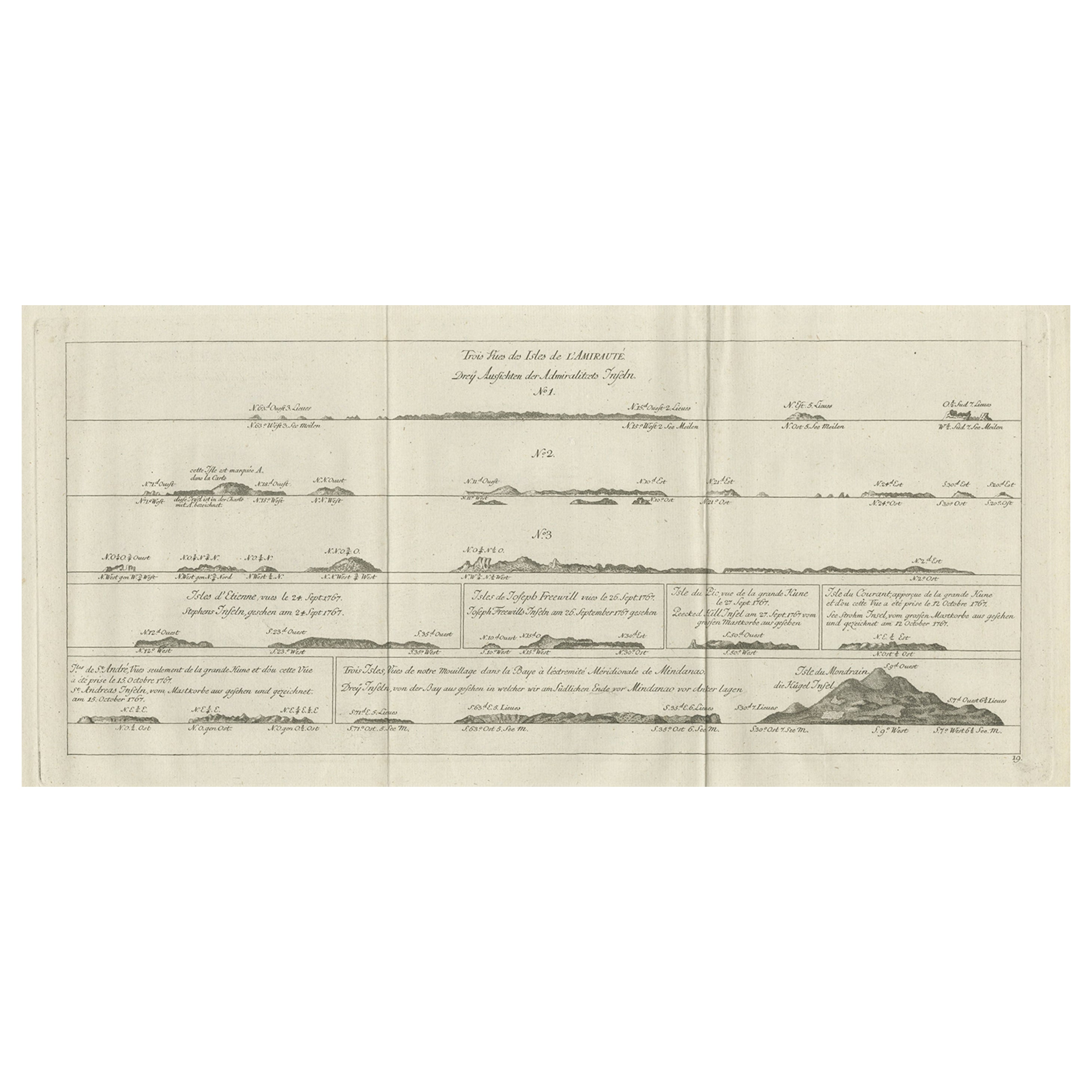
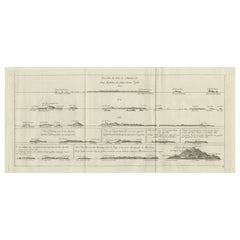
- Original Antique Engraving of the Admiralty Islands 'Bismarck Archipelago', 1774Located in Langweer, NLAntique print titled 'Trois Vues des Isles de l'Amirauté (..)'. Several coastal views of the Admiralty Islands. Originates from 'Geschichte der See-Reisen und Entdeckungen im Süd-Mee...Category
Antique 18th Century Prints
MaterialsPaper
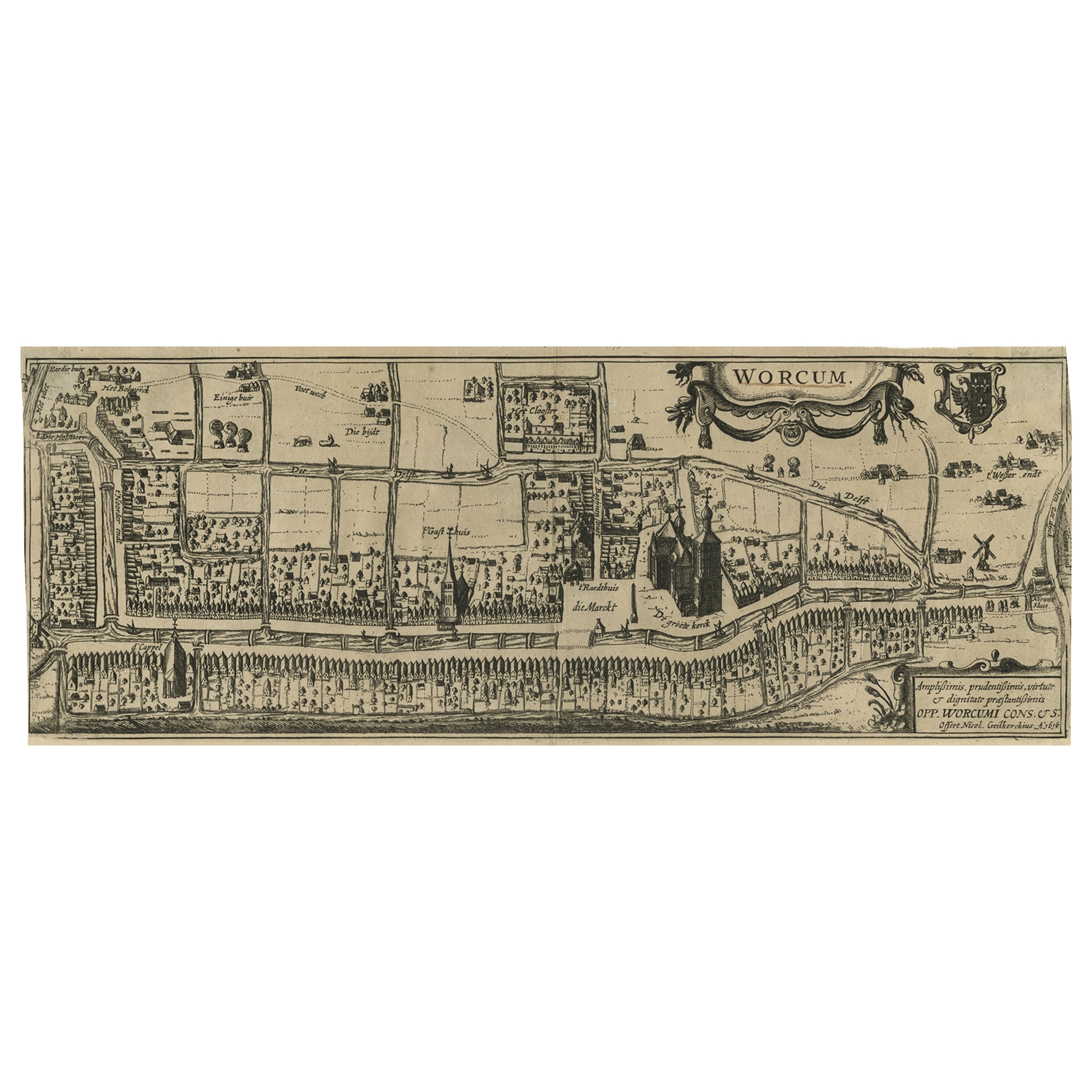
- Original Old & Rare View of the City of Workum, Friesland, The Netherlands, 1616Located in Langweer, NLAntique map titled 'Worcum'. This print depicts the city of Workum (Friesland, The Netherlands). With German captions. This print originates from 'Rerum Frisicarum Historia' publishe...Category
Antique 1610s Maps
MaterialsPaper


You May Also Like
- Original Antique Map / City Plan of Brussels by Tallis, circa 1850Located in St Annes, LancashireGreat map of Brussels. Steel engraving. Published by London Printing & Publishing Co. (Formerly Tallis), C.1850 Free shipping.Category
Antique 1850s English Maps
MaterialsPaper
- Catalogue of Engraved Views, Plans, Etc., Of New York City, 1st EdLocated in valatie, NYA catalogue of engraved views, plans, etc., Of New York City, (The Collection of Percy R. Pyne II). Privately Printed by The De Vinne Press, New York, 1912. Limited to 100 copies. Gr...Category
Early 20th Century American Books
MaterialsPaper
- N.E. View of the United States Capitol, Washington, DC Antique Proof Print 1858Located in Colorado Springs, COThis engraved print shows a view of the United States Capitol Building, in Washington, D.C. The print depicts the neoclassical building from the northeast orientation, with a bustling street scene in front. The steel engraving is a proof printing, drawn and engraved by Henry Sartain and published in 1858. Plans began in May 1854 to build a new cast-iron dome for the United States Capitol. The then-architect of the Capitol Thomas Walter and his team were sold on the aesthetics of a new dome, as well as the utility of a fire-proof one. A year later, on March 3, 1855, President Franklin Pierce...Category
Antique 1850s American Prints
MaterialsPaper
- City View of Nuremberg, Germany: An 18th Century Hand-Colored Map by M. SeutterBy Matthew SeutterLocated in Alamo, CAAn 18th century hand-colored city view of Nuremburg, Germany entitled "Geometrischer Grundris der des Heiligen Römischen Reichs Freyen Stadt Nürnberg" by Matthaus Seutter from his "A...Category
Antique Mid-18th Century German Maps
MaterialsPaper
- Vintage "View of the Center of Paris Taken from the Air" Lithograph MapLocated in San Diego, CAA very stylish "View of the Center of Paris Taken from the Air" lithograph map published by the Paris Ministry of Tourism, circa early 1950s. The piece measures 27" x 43" and shows...Category
20th Century French Mid-Century Modern Prints
MaterialsPaper
- 18th Century French Map and City View of Joppe/Jaffa 'Tel Aviv' by SansonBy Nicolas SansonLocated in Alamo, CAAn original antique engraving entitled "Joppe; in ’t Hebreeusch by ouds Japho; hedendaags Japha, of Jaffa; volgens d’aftekening gedaan 1668", by Nicholas Sanson d'Abbeville (1600 - 1667). This is a view of the city of Joppe (in Hebrew Japho), now called Japha or Jaffa, the harbor portion of modern day Tel Aviv, Israel as it appeared in 1668 . It depicts a very busy harbor with numerous boats. A large ship on the left appears to be firing its canons and a small ship on the right appears to be sitting very low in the water, either heavily loaded with cargo or sinking. The town is seen on the far shore with a fortress on a hill across in the background. The map is printed from the original Sanson copperplate and was published in 1709 by his descendants. The map is presented in an ornate brown wood frame embellished by gold-colored leaves and gold inner trim with a double mat; the outer mat is cream-colored and the inner mat is black. There is a central vertical fold, as issued. There are two small spots in the lower margin and one in the upper margin, as well as two tiny spots adjacent to the central fold. 1717 is written below the date 1668 in the inscription. The map is otherwise in very good condition. Another map of the "Holy Land" (by Claes Visscher in 1663), with an identical style frame and mat is available. This pair of maps would make a wonderful display grouping. Please see Reference #LU5206220653552. A discount is available for the purchase of the pair of maps. Artist: Nicholas Sanson d'Abbeville (1600-1667) and his descendents were important French cartographer's active through the 17th century. Sanson started his career as a historian and initially utilized cartography to illustrate his historical treatises. His maps came to the attention of Cardinal Richelieu and then King Louis XIII of France, who became a supporter and sponsor. He subsequently appointed Sanson 'Geographe Ordinaire du Roi' the official map maker to the king. Sanson not only created maps for the king, but advised him on geographical issues and curated his map collection...Category
Antique Early 18th Century French Maps
MaterialsPaper


Recently Viewed
View AllMore Ways To Browse
Antique Tabed
Antique Map Orient
Antique Egypt Map
Antique Map Egypt
Antique Map Of Egypt
Description Egypt
Map Of Arabia
Map Of Persia
Persia Map
Antique Map Of Persia
Antique Maps Persia
Map Of Palestine
Palestine Map
Antique Maps Palestine
Original Antique Map Of Persia
Antique Map Palestine
French Antique Front Door
Medieval Gold