E. W. Merrill Maps
1
to
1
1
1
1
1
1
1
1
1
1
1
1
1
104
63
29
26
Creator: E. W. Merrill
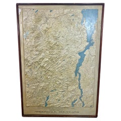
Rare and Early Plaster Relief Map of Adirondack Mountains by F J H Merrill
By E. W. Merrill, P.F. Howells
Located in Buffalo, NY
Rare and Early Monumental Plaster Relief Map of Adirondack Mountains by The University of the State of New York, New York State Museum..F J H Merrill director,,,modeled by Howell's ...
Category
1910s American Industrial Vintage E. W. Merrill Maps
Materials
Plaster, Wood
Related Items
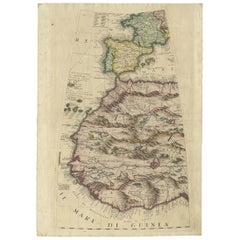
Rare Antique Map of Southwestern Europe and West Africa by V.M. Coronelli, 1692
By Vincenzo Coronelli
Located in Langweer, NL
Beautiful hand-colored example of the Southwestern Europe and West Africa globe gore from Coronelli's 42 inch Terrestrial Globe. The globe gore embraces France, Iberia and all of Africa west of a line running from Algeria down to the Bight of Benin, as well as the Canary Islands and Madeira. One of the most accurate and finely engraved cartographic depictions of its era, the coastline of Africa appears in well-formed detail. The interior, which was an almost complete enigma, is adorned with mythical mountain ranges and exotic animals such as giraffes, elephants, lions and strange giant birds. The Gambia...
Category
Late 17th Century Antique E. W. Merrill Maps
Materials
Paper
H 19.3 in W 13.59 in D 0.02 in
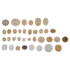
Rare Collection of 35 Antique Plaster Medal Models
Located in Alessandria, Piemonte
Rare collection of 35 plaster casts from XIX century, as Grand Tour Souvenir.
I found them like this: You can put them in frame according to the size...
Category
Early 19th Century Italian Neoclassical Antique E. W. Merrill Maps
Materials
Plaster
Rare Small Antique Map of Great Britain and Ireland
Located in Langweer, NL
Antique map titled 'La Grande Bretagne et Irlande'. Small antique map of Great Britain and Ireland. Source unknown, to be determined. Publ...
Category
Mid-18th Century Antique E. W. Merrill Maps
Materials
Paper
Rare Antique Map of Yam Suph, Egypt and Red Sea, 1773
Located in Langweer, NL
Antique print with two maps titled 'Uittreksel van de Kaart van Egipten en de Roode Zee' and 'Uittreksel uit de Kaart van Chrysanthus'. The left image shows Yam Suph, the body of wat...
Category
18th Century Antique E. W. Merrill Maps
Materials
Paper
World Relief Map
Located in Antwerp, BE
Large world relief map.
Measures: Width 232 cm.
Height 158 cm.
Category
Mid-20th Century German Mid-Century Modern E. W. Merrill Maps
Materials
Acrylic
Rare Set of 3 Map Samplers by A Charles. Italy, Spain & France
Located in Chelmsford, Essex
Set of 3 Map Samplers by A Charles. All depict countries, cities, seas and landmarks of the respective countries. The first entitled, 'SPAIN and PORTUGAL'. The second, 'MAP OF FRANCE...
Category
Early 19th Century English Antique E. W. Merrill Maps
Materials
Linen
Rare and Interesting Small Antique Woodcut Map of the Mediterranean, 1568
Located in Langweer, NL
Very rare untitled antique woodcut map showing the region of the missionary journeys of Apostle Paul. It shows the Mediterranean with Greece, Asia Minor (Turkey), Northern Africa, So...
Category
16th Century Antique E. W. Merrill Maps
Materials
Paper
H 5.63 in W 6.78 in D 0.02 in
Rare Antique Bible Map of Southern Europe by A. Schut, 1743
Located in Langweer, NL
Antique map of the Mediterranean and a large part of Europe, illustrating the voyage of St. Paul to Rome. This map originates from ‘Biblia Sacra, dat is, de H. Schriftuer van het Oud...
Category
Mid-18th Century Antique E. W. Merrill Maps
Materials
Paper
Antique Map of Northern Ireland by Mercator/Hondius, Early 1600's
Located in Langweer, NL
Antique map titled 'Ultoniae Orientalis Pars'. Original antique map of Northern Ireland. Published by Mercator/Hondius, ca. 1600.
Superb early map of the eastern part of Ulster, featuring Down and Antrim Counties in Northern Ireland. Mercator's famous moire pattern in the sea is used. Strong topographical features in the interior and ornamented with a title cartouche incorporating the distance scale.
This was one of five Irish maps...
Category
16th Century Antique E. W. Merrill Maps
Materials
Paper
Christie's, Estate of Doris Merrill Magowan, May, 2002
Located in valatie, NY
Christie's, Estate of Doris Merrill Magowan May, 2002 in New York. 1st Ed softcover auction catalogue. 195 pp and 225 lots all photographed in color and full...
Category
Early 2000s American E. W. Merrill Maps
Materials
Paper
Antique Engraving of a Map or Plan of Jerusalem and Surrounding Mountains, 1773
Located in Langweer, NL
Antique map titled 'Platte grond van Jerusalem, en de omliggende Bergen'. Plan of the city of Jerusalem, with surrounding mountains. Originates from the first Dutch editon of an inte...
Category
18th Century Antique E. W. Merrill Maps
Materials
Paper
H 14.18 in W 10.24 in D 0 in
Antique Map of the Mountain Chains of Europe and Asia by Johnston '1850'
Located in Langweer, NL
Antique map titled 'The Mountain chains of the Europe and Asia '. Original antique map of the mountain chains of Europe and Asia. This map originates from 'The Physical Atlas of Natu...
Category
Mid-19th Century Antique E. W. Merrill Maps
Materials
Paper
H 11.03 in W 14.18 in D 0.02 in
E. W. Merrill maps for sale on 1stDibs.
E. W. Merrill maps are available for sale on 1stDibs. These distinctive items are frequently made of wood and are designed with extraordinary care. Many of the original maps by E. W. Merrill were created in the industrial style in united states during the 1910s. Prices for E. W. Merrill maps can differ depending upon size, time period and other attributes — on 1stDibs, these items begin at $3,200 and can go as high as $3,200, while a piece like these, on average, fetch $3,200.


