Items Similar to Antique Map of Celtic Europe by Cluver, 1678

Want more images or videos?
Request additional images or videos from the seller
Antique Map of Celtic Europe by Cluver, 1678
About the Item
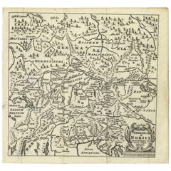
Antique map Europe titled 'Europam sive Celticam Veterem'. Rare map of Celtic Europe. Made after A. Ortelius, originates from 'Introductionis in universam geographicarum' by P. Cluver.
Artists and Engravers: Published by J. Duncker.
Condition: Very good, general age-related toning. Please study image carefully.
Date: 1678
Overall size: 28.5 x 22 cm.
Image size: 20.5 x 15.5 cm.
We sell original antique maps to collectors, historians, educators and interior decorators all over the world. Our collection includes a wide range of authentic antique maps from the 16th to the 20th centuries. Buying and collecting antique maps is a tradition that goes back hundreds of years. Antique maps have proved a richly rewarding investment over the past decade, thanks to a growing appreciation of their unique historical appeal. Today the decorative qualities of antique maps are widely recognized by interior designers who appreciate their beauty and design flexibility. Depending on the individual map, presentation, and context, a rare or antique map can be modern, traditional, abstract, figurative, serious or whimsical. We offer a wide range of authentic antique maps for any budget.
- Dimensions:Height: 8.67 in (22 cm)Width: 11.23 in (28.5 cm)Depth: 0 in (0.01 mm)
- Materials and Techniques:
- Period:
- Date of Manufacture:1678
- Condition:
- Seller Location:Langweer, NL
- Reference Number:
About the Seller
5.0
Platinum Seller
These expertly vetted sellers are 1stDibs' most experienced sellers and are rated highest by our customers.
Established in 2009
1stDibs seller since 2017
1,950 sales on 1stDibs
Typical response time: <1 hour
- ShippingRetrieving quote...Ships From: Langweer, Netherlands
- Return PolicyA return for this item may be initiated within 14 days of delivery.
More From This SellerView All
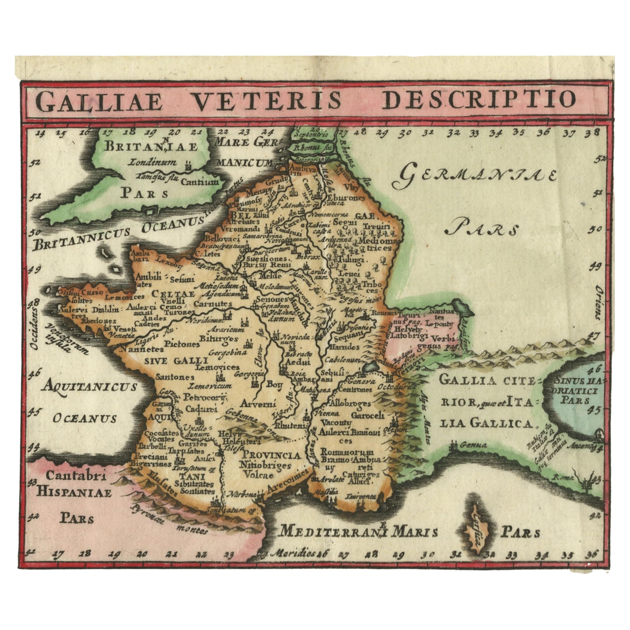
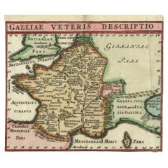
- Antique Map of France by Cluver, 1685Located in Langweer, NLAntique map titled 'Galliae Veteris Descriptio.' Charming miniature map of France from the pocket atlas 'Introductionis in Universam Geographiam tam Veterem quam novam .. Acessit P. ...Category
Antique 17th Century Maps
MaterialsPaper
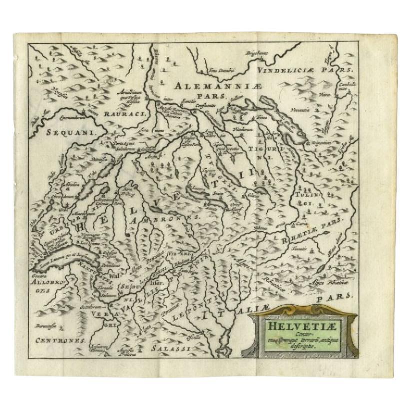
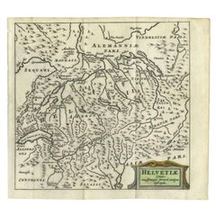
- Antique Map of Switzerland by Cluver, 1685Located in Langweer, NLAntique map titled 'Helvetiae Conterminarumque Terrarii, antiqua descriptio.' Miniature map of Switzerland, from the pocket atlas 'Introductionis in...Category
Antique 17th Century Maps
MaterialsPaper
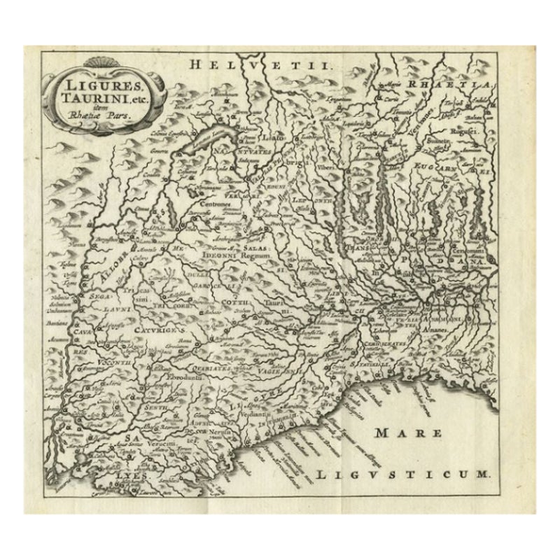
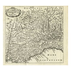
- Antique Map of Northwest Italy by Cluver, 1685Located in Langweer, NLAntique map titled 'Ligures, Taurini, etc.' Miniature map of northwest Italy. From the pocket atlas 'Introductionis in Universam Geographiam tam Veterem quam novam .. Acessit P. Bert...Category
Antique 17th Century Maps
MaterialsPaper
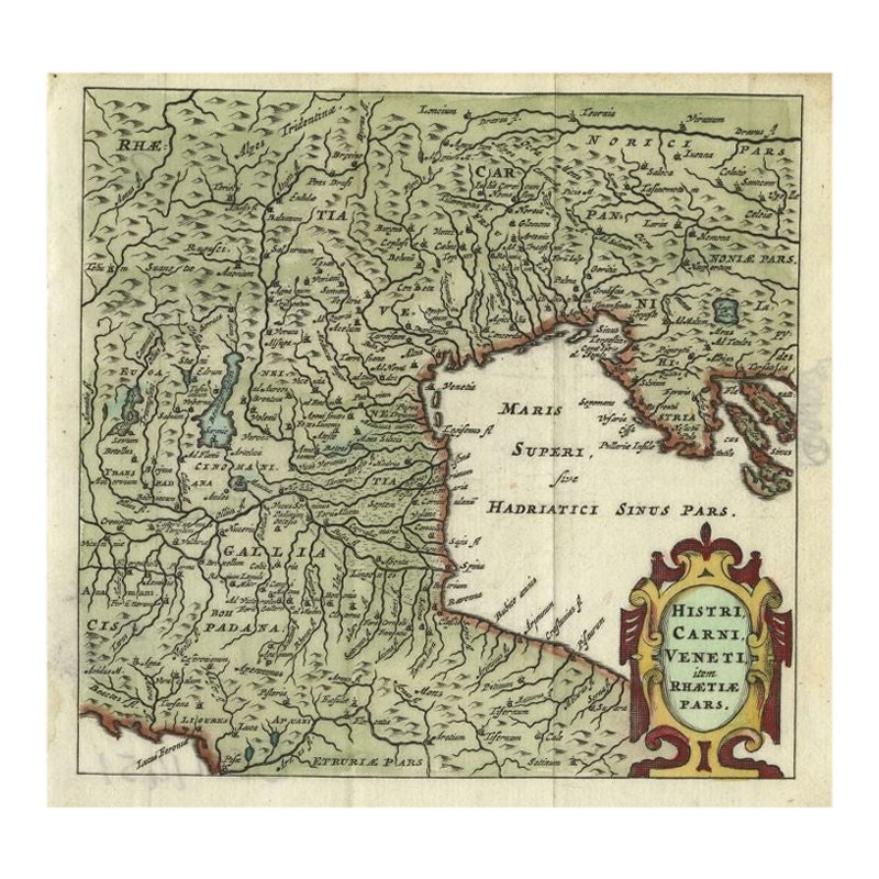
- Antique Map of Northern Italy by Cluver, 1685Located in Langweer, NLAntique map titled 'Histri, Carni, Veneti item Rhaetiae Pars.' Charming miniature map of northern Italy with the Adriatic or upper sea, now called the Gulf of Venice, from the pocket...Category
Antique 17th Century Maps
MaterialsPaper
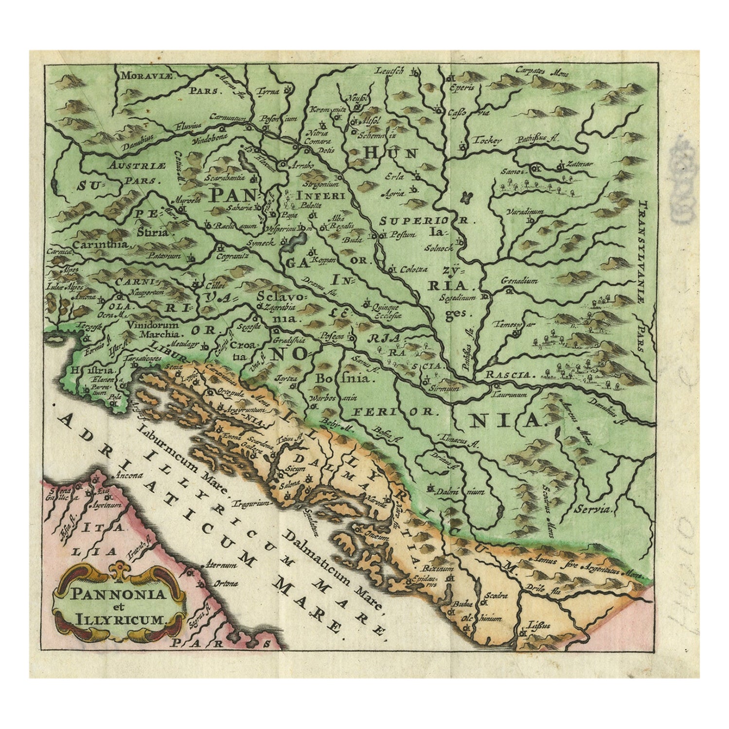
- Antique Map of Pannonia and Illyria by Cluver, 1685Located in Langweer, NLAntique map titled 'Pannonia et Illyricum.' Charming miniature map of Pannonia and Illyria, from the pocket atlas 'Introductionis in Universam Geographiam tam Veterem quam novam .. A...Category
Antique 17th Century Maps
MaterialsPaper
- Antique Map of Southern Germany and Switzerland by Cluver, 1685Located in Langweer, NL"Antique map titled 'Vindeliciae et Norici conterminarunque terrarum antiqua descriptio.' Miniature map of south Germany and Switzerland in Celtic times, From the pocket atlas 'Intro...Category
Antique 17th Century Maps
MaterialsPaper


You May Also Like
- Antique Hand Colored Framed Map of EuropeLocated in West Palm Beach, FLAntique reproduction copied from an edition dated 1595 by Ortelius.Category
Antique Late 19th Century Maps
- Large Original Antique Map of Europe by Sidney Hall, 1847Located in St Annes, LancashireGreat map of Europe Drawn and engraved by Sidney Hall Steel engraving Original colour outline Published by A & C Black. 1847 Unframed Free shipping.Category
Antique 1840s Scottish Maps
MaterialsPaper
- Antique Puzzle of Colored Cardboard Depicting World Map, Europe and FranceLocated in Milan, ITEducational puzzle of colored cardboard composed of three folders depicting world map, Europe and France. The world map in addition to the territorial map of the continents depicts t...Category
Antique 1850s French Games
MaterialsPaper
- 1861 Topographical Map of the District of Columbia, by Boschke, Antique MapLocated in Colorado Springs, COPresented is an original map of Albert Boschke's extremely sought-after "Topographical Map of the District of Columbia Surveyed in the Years 1856 ...Category
Antique 1860s American Historical Memorabilia
MaterialsPaper
- 1907 Map of Colorado, Antique Topographical Map, by Louis NellLocated in Colorado Springs, COThis highly detailed pocket map is a topographical map of the state of Colorado by Louis Nell from 1907. The map "has been complied from all availabl...Category
Antique Early 1900s American Maps
MaterialsPaper
- 1849 Map of "Europaische Russland", 'Meyer Map of European Russia', Ric. R017Located in Norton, MA1849 Map of "Europaische Russland" ( Meyer Map of European Russia) Ric.r017 A lovely map of European Russia dating to 1849 by Joseph Meyer. It covers the European portions of...Category
Antique 19th Century Unknown Maps
MaterialsPaper


Recently Viewed
View AllMore Ways To Browse
Antique Europe Map
Antique European Maps
Antique European Map
Antique Maps Europe Maps
Europe Map Antique
Antique Maps Of Europe
Celtic Furniture
Antique Celtic
Celtic Design
17th Century World Map
Antique Map Europe
Antique Map Of Europe
Antique 17th Century World Map
Celtic Antiques
Antique Map Ortelius
Antique Maps Ortelius
Texas Antique Furniture
Antique Texas Furniture