Articles similaires à Botanical Map by A.K. Johnston – Global Plant Distribution Chart 1852


Vous voulez plus d'images ou de vidéos ?
Demander au vendeur plus d'images ou de vidéos
1 sur 10
Botanical Map by A.K. Johnston – Global Plant Distribution Chart 1852
260 €par article|TVA incluse
Quantité
À propos de cet article
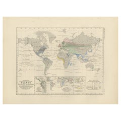
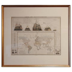
Botanical Map by A.K. Johnston – Global Plant Distribution Chart 1852
This remarkable antique chart titled "The Distribution of the Most Important Trees, Shrubs, Grains, & Fruits According to Zones of Climate & Moisture" was created by Alexander Keith Johnston and published in 1852 by William Blackwood & Sons, Edinburgh and London. It is Plate 15 from Johnston’s revolutionary *Physical Atlas of Natural Phenomena*, a foundational work in scientific cartography.
This thematic map combines botanical geography and climatology to illustrate how vegetation and agricultural crops are distributed across the globe according to climatic zones and moisture levels. Zones such as the "Climate of the Tropics," "European & Tropical," and "Northern Zone of Perpetual Ice and Snow" are color-coded and labeled with the dominant plants, fruits, or grains associated with each area.
The map meticulously annotates where particular species grow best: bananas and sugarcane in equatorial regions, wheat and apples in temperate zones, palms and spice trees in the tropics, and mosses and berries in the Arctic. The influence of rainfall and elevation is also emphasized, providing a multidimensional understanding of global botanical ecology as understood in the 19th century.
Beneath the main map is a stunning cross-sectional diagram titled "Distribution of Plants in a Vertical Direction," illustrating mountain ecosystems from the Rocky Mountains and Andes to the Himalayas and Alps. As the elevation rises, the vegetation zones change—from tropical palms at the base to alpine mosses and lichens near the peaks—offering a visual summary of how altitude affects plant distribution as dramatically as latitude.
Alexander Keith Johnston (1804–1871), a leading figure in Victorian science and cartography, was Geographer in Ordinary to Queen Victoria in Scotland. His work revolutionized the use of maps to present scientific data, and his *Physical Atlas* is still admired for its clarity, elegance, and educational ambition.
This chart is a must-have for collectors of botanical history, early climatology, or decorative scientific illustrations. Its blend of empirical data and visual storytelling is both informative and visually compelling.
Condition and framing tips:
Very good antique condition with minor age toning and a clean printed surface. A striking plate for display, best framed in walnut or gold with a warm ivory mat to highlight the earthy tones and detailed illustrations. Ideal for a library, conservatory, or academic interior.
- Dimensions:Hauteur : 27,4 cm (10,79 po)Largeur : 34,5 cm (13,59 po)Profondeur : 0,2 mm (0,01 po)
- Matériaux et techniques:
- Lieu d'origine:
- Période:
- Date de fabrication:1852
- État:Very good condition. Light overall toning near the margins. The paper remains strong and well-preserved. Folding line as issued.
- Adresse du vendeur:Langweer, NL
- Numéro de référence:Vendeur : BG-13207-151stDibs : LU3054345393502
À propos du vendeur
5,0
Vendeur reconnu
Ces vendeurs prestigieux sont des leaders du secteur. Ils représentent le summum en matière de qualité et de design.
Vendeur Platine
Vendeurs premium dont la note est supérieure à 4,7 et le délai de réponse de 24 heures maximum
Établi en 2009
Vendeur 1stDibs depuis 2017
2 641 ventes sur 1stDibs
Temps de réponse habituel : <1 heure
- ExpéditionRecherche du devis...Expédition depuis : Langweer, Pays-Bas
- Politique des retours
Certaines parties de cette page ont été traduites automatiquement. 1stDibs ne garantit pas l'exactitude des traductions. L'anglais est la langue par défaut de ce site web.
Garantie d'authenticité
Bien qu'il soit peu probable que la situation se présente, dans le cas où vous rencontreriez un problème d'authenticité d'un article, contactez-nous dans un délai d'un an pour obtenir un remboursement intégral. DétailsGarantie de remboursement
Si votre article n'est pas conforme à la description, est endommagé pendant le transport ou ne vous est pas livré, contactez-nous sous 7 jours pour obtenir un remboursement intégral. DétailsAnnulation sous 24 heures
Vous disposez d'un délai de 24 heures pour annuler votre achat sans motif.Des vendeurs professionnels agréés
Nos vendeurs de renommée mondiale doivent respecter des normes strictes en matière de service et de qualité, afin de préserver l'intégrité de nos fiches produit.Garantie d'alignement des prix
Si vous constatez qu'un autre vendeur a mis en vente le même article à un prix inférieur sur un autre site, nous nous alignerons sur ce prix.Livraison en toute confiance à l'international
Notre réseau de transporteurs de premier ordre propose des options d'expédition spécialisées dans le monde entier, y compris des livraisons personnalisées.Plus d'articles de ce vendeur
Tout afficherCarte ancienne montrant la distribution des plantes par Johnston, '1850'
Carte ancienne intitulée "Distribution géographique des plantes". Carte ancienne originale montrant la répartition des plantes. Cette carte est tirée de "The Physical Atlas of Natura...
Catégorie
Antiquités, Milieu du XIXe siècle, Cartes
Matériaux
Papier

160 € Prix de vente
20 % de remise
Carte ancienne du monde montrant la distribution des plantes et des minéraux, 1872
Carte ancienne intitulée "Johnson's World showing the distribution of the Characteristic Forest Trees (...)". Carte du monde originale montrant la répartition des plantes et des miné...
Catégorie
Antiquités, Fin du XIXe siècle, Cartes
Matériaux
Papier

160 € Prix de vente
20 % de remise
Carte ancienne montrant la distribution des plantes par Johnston '1850'
Carte ancienne intitulée "Plantes géographiques utilisées pour l'alimentation de l'homme". Carte ancienne originale montrant la répartition des plantes. Cette carte provient de "The ...
Catégorie
Antiquités, Milieu du XIXe siècle, Cartes
Matériaux
Papier
160 € Prix de vente
20 % de remise
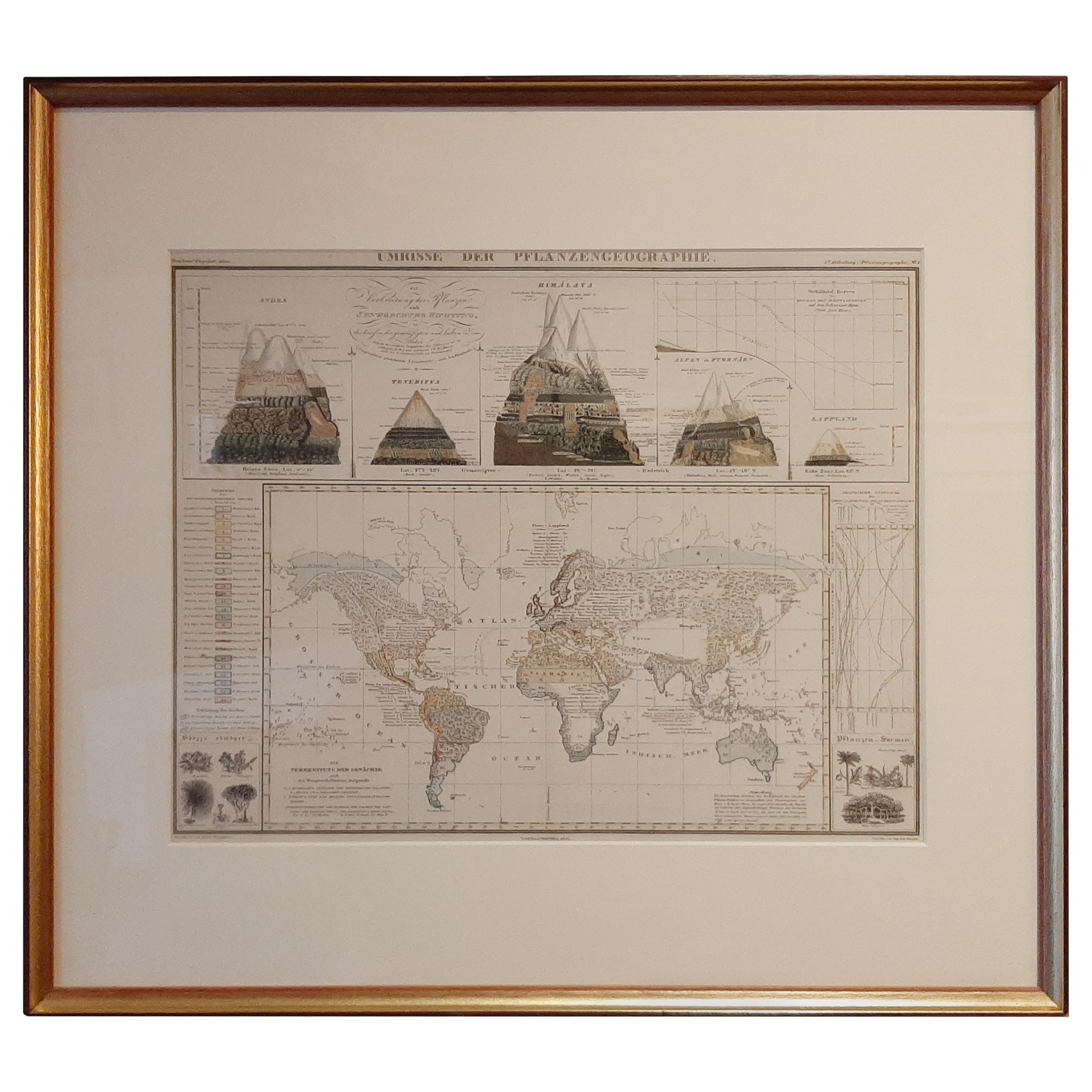
Carte ancienne de la distribution de la végétation à travers le monde '1851'
Carte ancienne intitulée "Umrisse der Pflanzengeographie". Carte ancienne originale montrant la répartition de la végétation dans le monde. Cinq dessins au-dessus de la carte montren...
Catégorie
Antiquités, Milieu du XIXe siècle, Cartes
Matériaux
Papier
600 € Prix de vente
20 % de remise
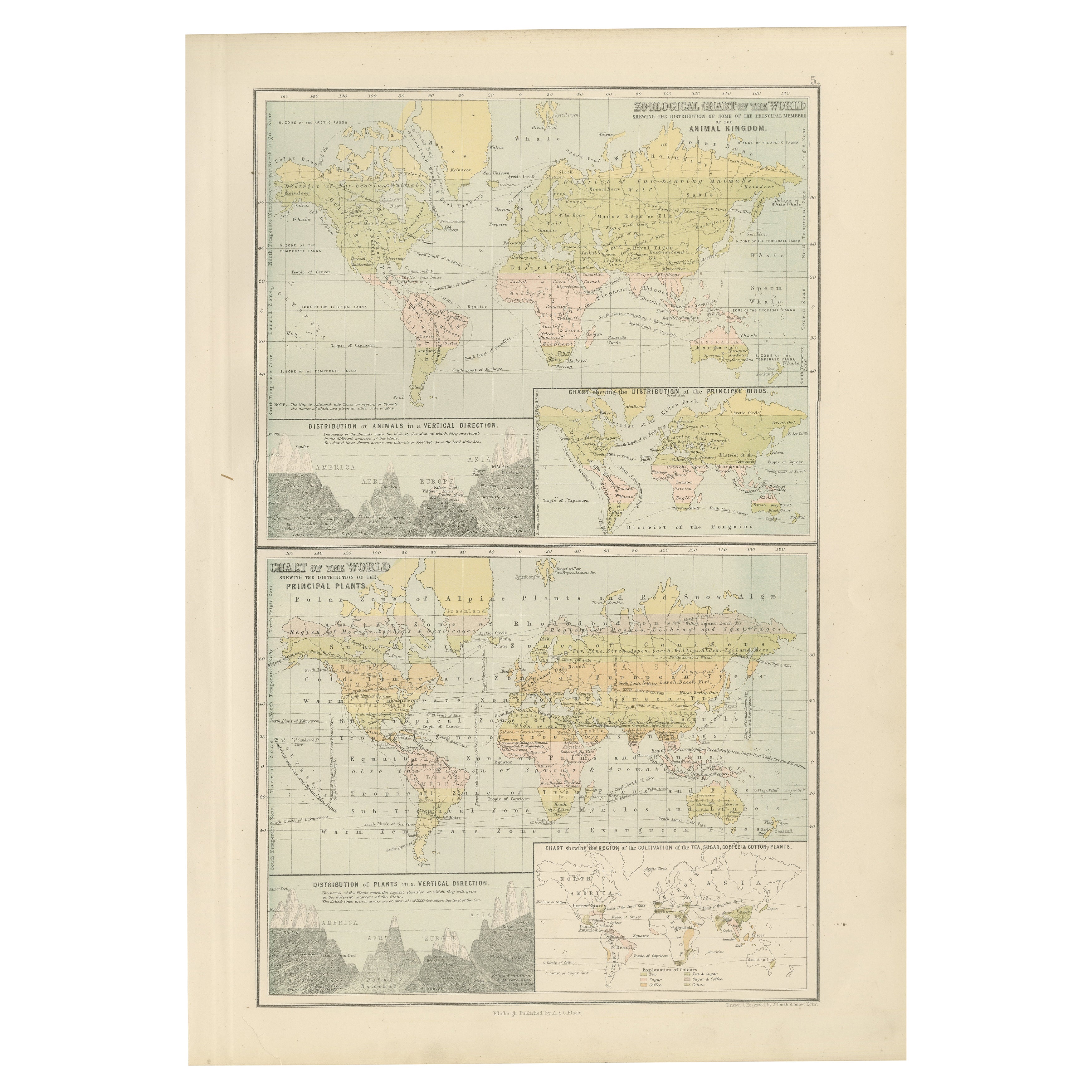
Ancienne carte zoologique et botanique du monde - Carte décorative, 1884
Anciennes cartes zoologiques et botaniques du monde - Black's Atlas, 1884
Cette double planche de la New and Revised Edition of Black's General Atlas of the World, publiée à Édimbou...
Catégorie
Antiquités, années 1880, Écossais, Cartes
Matériaux
Papier
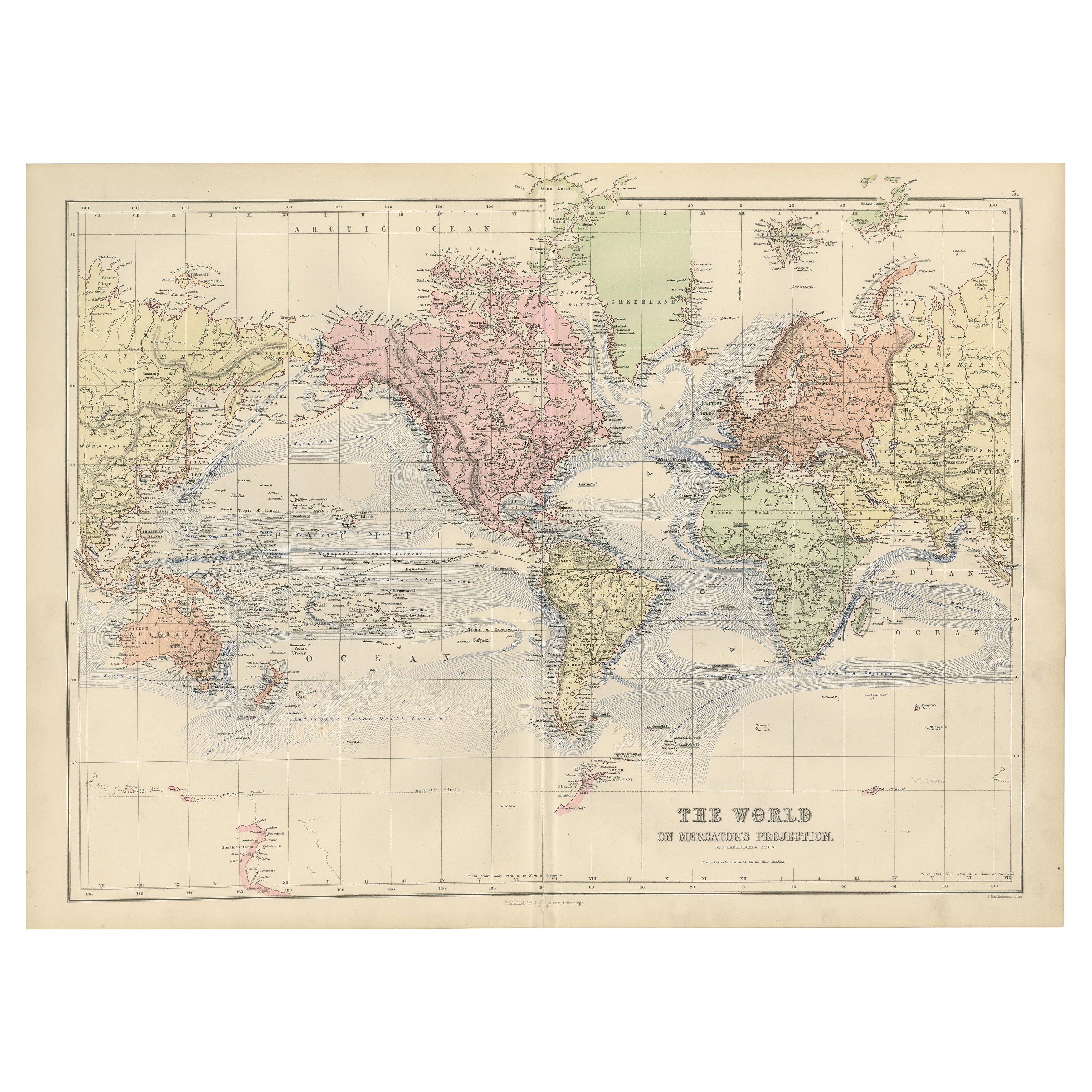
1884 Carte du monde décorative ancienne - Projection de Mercator, Impression de l'époque victorienne
Ancienne carte du monde sur la projection de Mercator - Black's Atlas, 1884
Cette carte finement gravée et colorée, intitulée The World on Mercator's Projection, a été publiée dans ...
Catégorie
Antiquités, années 1880, Écossais, Cartes
Matériaux
Papier

Suggestions
Carte du monde originale et ancienne par Dower, vers 1835
Belle carte du monde
Dessiné et gravé par J.Dower
Publié par Orr & Smith. C.1835
Non encadré.
Expédition gratuite
Catégorie
Antiquités, années 1830, Anglais, Cartes
Matériaux
Papier

Planisphere originale illustrée - Carte du monde - Géographie, 1864
Plongez dans l'épopée du passé avec le Planisphère historique illustré de 1864 par Charpentier ! 🗺️ Ce trésor cartographique vous transporte dans les méandres de l'histoire, avec de...
Catégorie
années 1860, Estampes et éditions
Matériaux
Lin, Lithographie, Papier

Carte originale et ancienne du monde par Thomas Clerk, 1817
Grande carte des hémisphères oriental et occidental
Sur 2 feuilles
Gravure sur cuivre
Dessiné et gravé par Thomas Clerk, Édimbourg.
Publié par Mackenzie et Dent, 1817
...
Catégorie
Antiquités, années 1810, Anglais, Cartes
Matériaux
Papier

Carte ancienne originale de l'hémisphère occidental par Dower, vers 1835
Belle carte de l'hémisphère occidental
Dessiné et gravé par J.Dower
Publié par Orr & Smith. C.1835
Non encadré.
Expédition gratuite
Catégorie
Antiquités, années 1830, Anglais, Cartes
Matériaux
Papier

Grande carte ancienne originale du monde, Fullarton, vers 1870
Superbe carte du monde. Montrer les deux hémisphères
Extrait du célèbre Royal Illustrated Atlas
Lithographie. Couleur originale.
Publié par Fullarton, Edinburgh, C.1870.
Sans ca...
Catégorie
Antiquités, années 1870, Écossais, Cartes
Matériaux
Papier

John Thomson (1777-1840) - gravure d'une carte de 1830, carte du monde
Par John Thomson
Belle carte gravée du monde sur la projection de Mercator, tirée de la deuxième édition du "New General Atlas" de John Thomson, publiée en 1830. Sur le papier.
Catégorie
Début du XIXe siècle, Plus d'Estampes
Matériaux
Gravure
273 € Prix de vente
20 % de remise