Articles similaires à Geological Map of the British Isles by A.K. Johnston – Highlands & Valleys 1852


Vous voulez plus d'images ou de vidéos ?
Demander au vendeur plus d'images ou de vidéos
1 sur 10
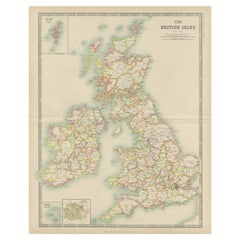
Geological Map of the British Isles by A.K. Johnston – Highlands & Valleys 1852
260 €par article|TVA incluse
Quantité
À propos de cet article
Geological Map of the British Isles by A.K. Johnston – Highlands & Valleys 1852
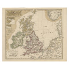
This antique topographic map titled "The Mountains, Table Lands, Plains & Valleys of the British Isles" was created by Alexander Keith Johnston and published in 1852 by William Blackwood & Sons in Edinburgh and London. It forms Plate 10 in Johnston’s landmark *Physical Atlas of Natural Phenomena*, one of the most influential works of thematic cartography of the 19th century.
The map offers a clear and scientific representation of the physical geography of Great Britain and Ireland, highlighting major mountain ranges, highlands, plains, river valleys, and tablelands using fine engraved detail and hand-applied color washes. Rather than depicting political boundaries, this plate focuses entirely on natural landforms and their elevations, providing insight into the geological character of the region.
Key physical features include the Highlands and Grampians of Scotland, the Pennines in northern England, the Cambrian Mountains of Wales, and the Cumbrian Fells. Ireland is shown with its central lowlands ringed by uplands, and an inset in the upper right corner details the Shetland Islands. Rivers such as the Thames, Shannon, Severn, and Clyde are precisely mapped, and lowland basins like those surrounding the Wash and the Fens are delicately shaded in green.
This map reflects the mid-19th century shift from political and colonial maps to scientific and thematic cartography. Alexander Keith Johnston (1804–1871), Geographer in Ordinary to Queen Victoria in Scotland, was one of the leading cartographic figures of his time. His *Physical Atlas* was the first to systematically visualize natural phenomena on a global scale through beautifully engraved and colored maps. This map is part of that series and stands as a testament to the combination of precision, clarity, and aesthetic quality in Victorian scientific publishing.
Highly collectible and still relevant today, this plate is perfect for historians, educators, or anyone with an interest in British natural history and geography.
Condition and framing tips:
Very good antique condition with minor age toning and a clean printed surface. Original centerfold as issued.
Ideal for framing in walnut, oak, or black wood with a warm ivory or cool grey mat to complement the greens and earth tones. A beautiful addition to a study, library, or historically inspired interior.
- Dimensions:Hauteur : 34,5 cm (13,59 po)Largeur : 27,4 cm (10,79 po)Profondeur : 0,2 mm (0,01 po)
- Matériaux et techniques:
- Lieu d'origine:
- Période:
- Date de fabrication:1852
- État:Very good condition. Light overall toning near the margins. The paper remains strong and well-preserved. Folding line as issued.
- Adresse du vendeur:Langweer, NL
- Numéro de référence:Vendeur : BG-13207-101stDibs : LU3054345388152
À propos du vendeur
5,0
Vendeur reconnu
Ces vendeurs prestigieux sont des leaders du secteur. Ils représentent le summum en matière de qualité et de design.
Vendeur Platine
Vendeurs premium dont la note est supérieure à 4,7 et le délai de réponse de 24 heures maximum
Établi en 2009
Vendeur 1stDibs depuis 2017
2 626 ventes sur 1stDibs
Temps de réponse habituel : <1 heure
- ExpéditionRecherche du devis...Expédition depuis : Langweer, Pays-Bas
- Politique des retours
Certaines parties de cette page ont été traduites automatiquement. 1stDibs ne garantit pas l'exactitude des traductions. L'anglais est la langue par défaut de ce site web.
Garantie d'authenticité
Bien qu'il soit peu probable que la situation se présente, dans le cas où vous rencontreriez un problème d'authenticité d'un article, contactez-nous dans un délai d'un an pour obtenir un remboursement intégral. DétailsGarantie de remboursement
Si votre article n'est pas conforme à la description, est endommagé pendant le transport ou ne vous est pas livré, contactez-nous sous 7 jours pour obtenir un remboursement intégral. DétailsAnnulation sous 24 heures
Vous disposez d'un délai de 24 heures pour annuler votre achat sans motif.Des vendeurs professionnels agréés
Nos vendeurs de renommée mondiale doivent respecter des normes strictes en matière de service et de qualité, afin de préserver l'intégrité de nos fiches produit.Garantie d'alignement des prix
Si vous constatez qu'un autre vendeur a mis en vente le même article à un prix inférieur sur un autre site, nous nous alignerons sur ce prix.Livraison en toute confiance à l'international
Notre réseau de transporteurs de premier ordre propose des options d'expédition spécialisées dans le monde entier, y compris des livraisons personnalisées.Plus d'articles de ce vendeur
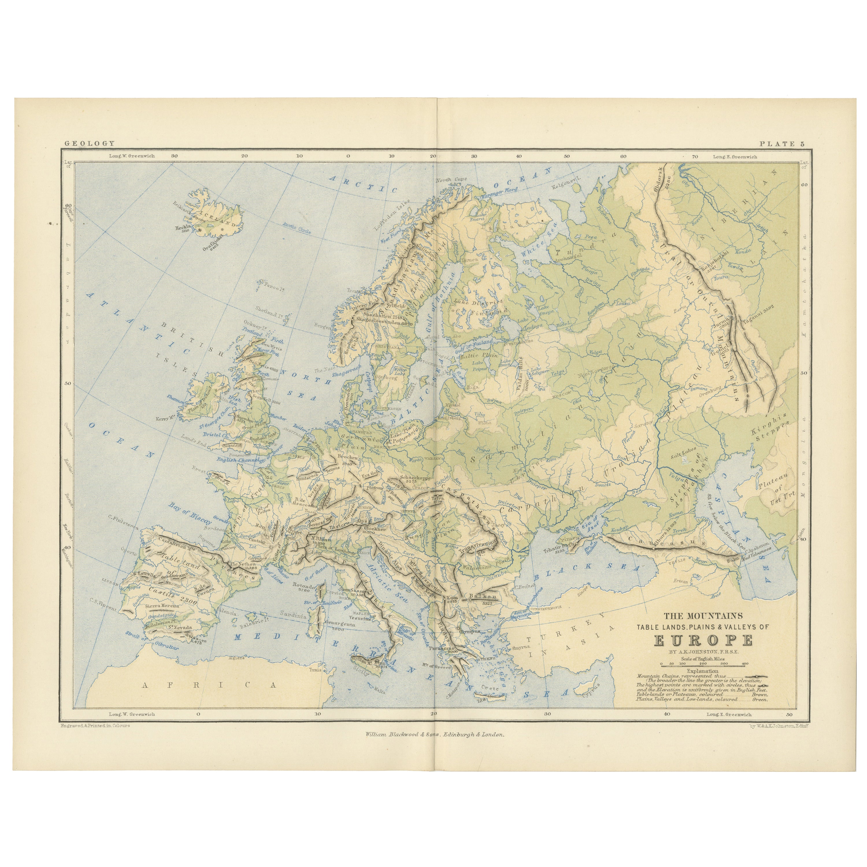
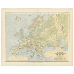
Tout afficherGeological Map of Europe by A.K. Johnston – Mountains and Valleys 1852
Geological Map of Europe by A.K. Johnston – Mountains and Valleys 1852
This elegant 1852 map titled "The Mountains, Table Lands, Plains & Valleys of Europe" was designed by the accl...
Catégorie
Antiquités, Milieu du XIXe siècle, Écossais, Estampes
Matériaux
Papier
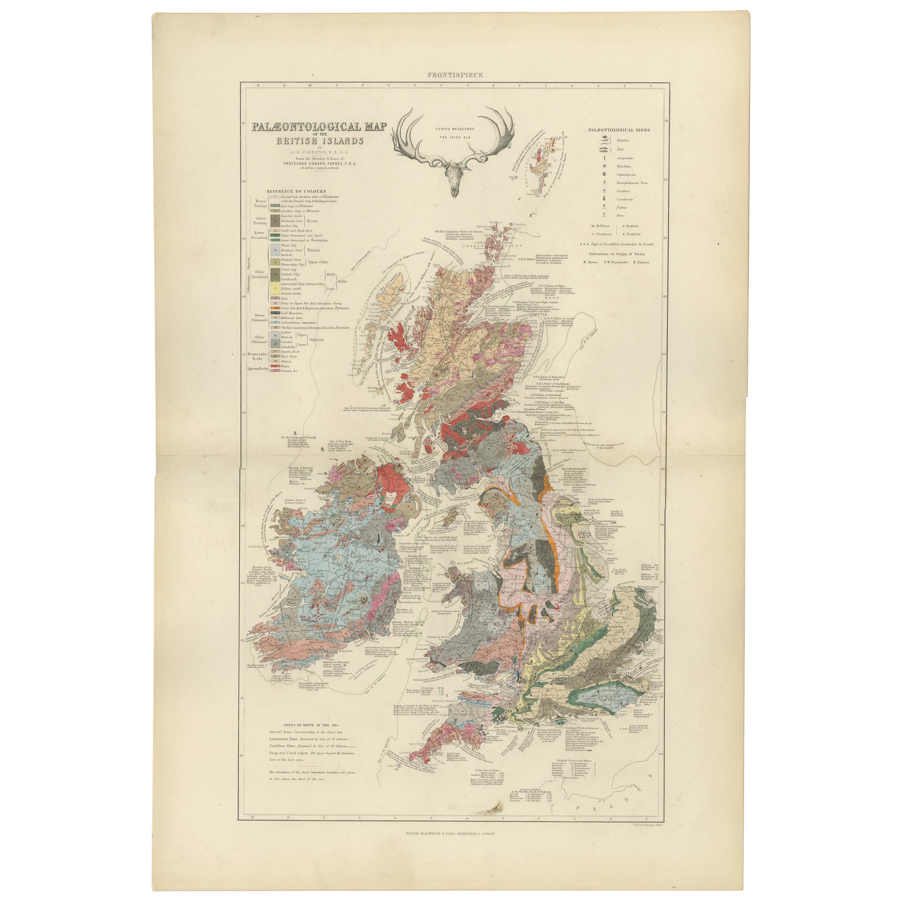
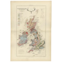
Carte ancienne de la Palaeontologie des îles britanniques par Johnston '1850'
Carte ancienne intitulée "Palaeontological Map of the British Islands". Carte ancienne originale montrant la paléontologie des îles britanniques. Cette carte provient de "The Physica...
Catégorie
Antiquités, Milieu du XIXe siècle, Cartes
Matériaux
Papier
360 € Prix de vente
20 % de remise
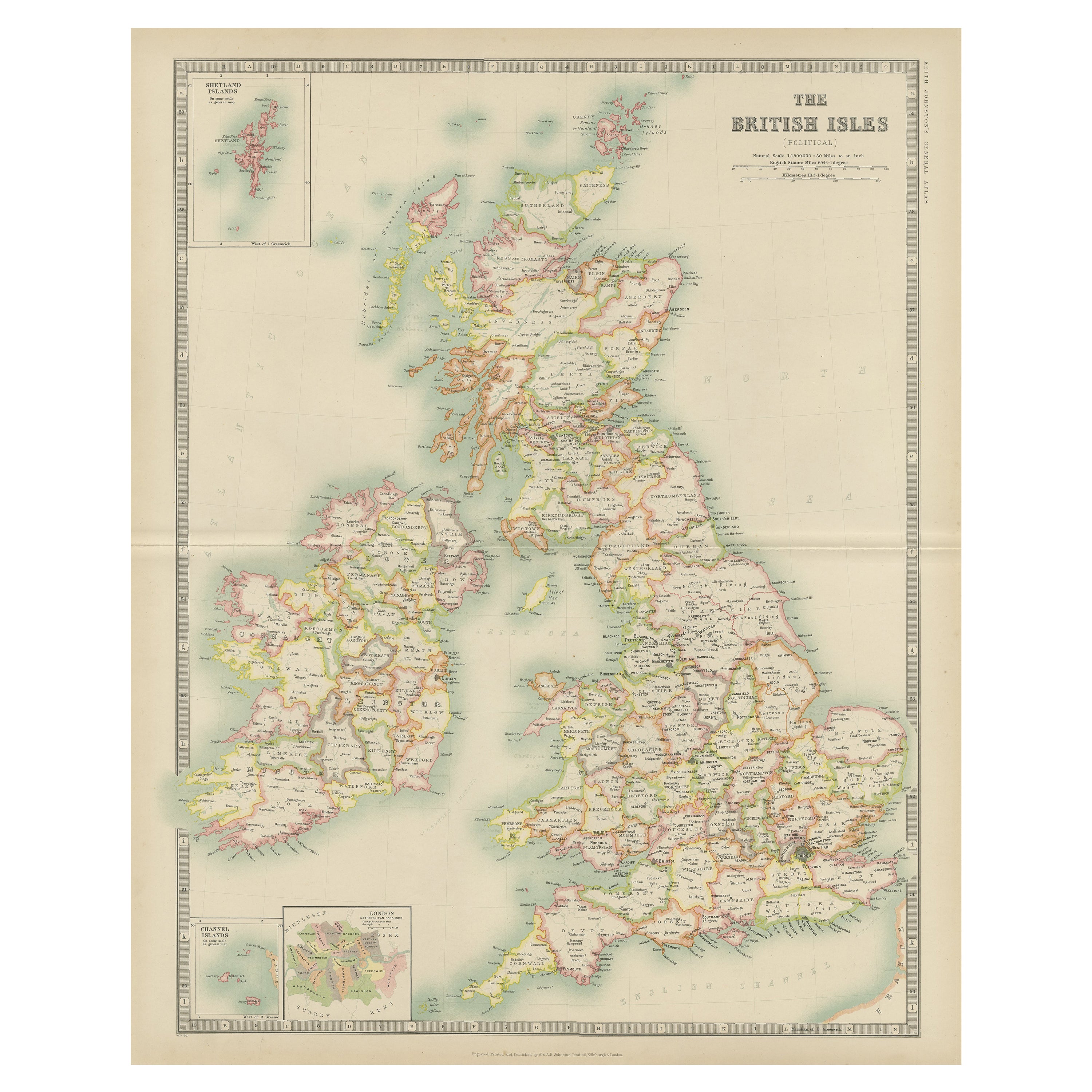
Carte ancienne des îles britanniques par Johnston '1909'
Carte ancienne intitulée "The British Isles". Carte ancienne originale des îles britanniques. Avec des cartes en médaillon des îles Shetland, des îles Chanel et de Londres. Cette car...
Catégorie
Début du 20ème siècle, Cartes
Matériaux
Papier
200 € Prix de vente
20 % de remise
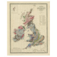
Sous la surface : l'estimation géologique des îles britanniques de James Wyld, 1844
Cette superbe carte géologique originale du Royaume-Uni de Grande-Bretagne et d'Irlande, réalisée par James Wyld en 1844, est un remarquable objet de l'époque victorienne.
Descript...
Catégorie
Antiquités, années 1840, Cartes
Matériaux
Papier
720 € Prix de vente
20 % de remise
Carte ancienne des îles britanniques par Balbi '1847'
Carte ancienne intitulée "Iles Britanniques". Carte ancienne originale des îles britanniques. Cette carte provient de l'Abrégé de géographie (...) d'Adrien Balbi. Publié en 1847.
Catégorie
Antiquités, Milieu du XIXe siècle, Cartes
Matériaux
Papier

120 € Prix de vente
20 % de remise
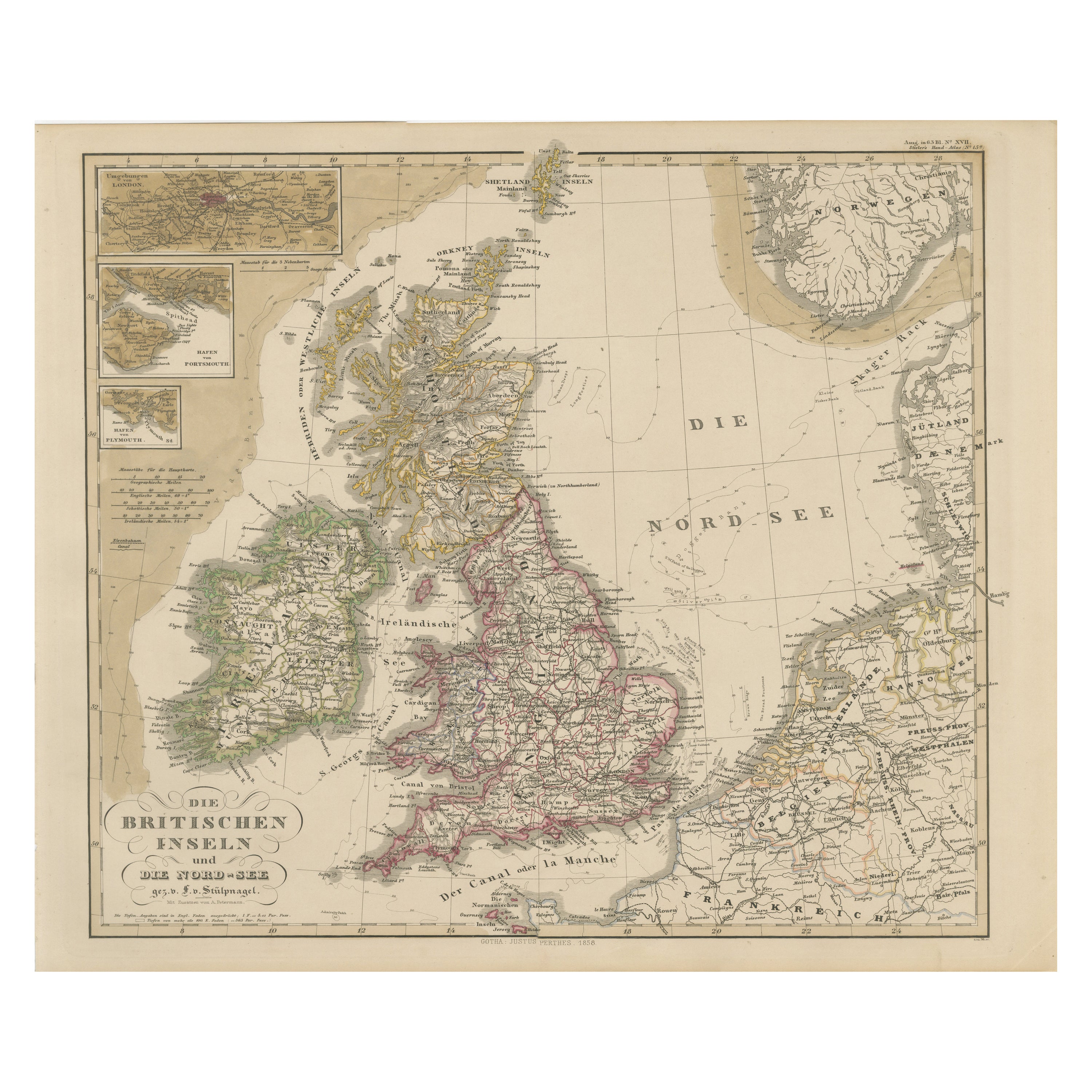
Carte ancienne de la Grande-Bretagne et de l'Irlande avec détails de la mer du Nord - 1856 Stülpnagel
Carte ancienne des îles britanniques et de la mer du Nord par Stülpnagel, 1856
Cette carte magnifiquement détaillée de 1856 intitulée *"Die Britischen Inseln und die Nord-See "* a é...
Catégorie
Antiquités, Milieu du XIXe siècle, Allemand, Cartes
Matériaux
Papier
Suggestions
Carte ancienne originale de l'Ecosse par Dower, vers 1835
Belle carte de l'Ecosse
Dessiné et gravé par J.Dower
Publié par Orr & Smith. C.1835
Non encadré.
Expédition gratuite
Catégorie
Antiquités, années 1830, Anglais, Cartes
Matériaux
Papier

Angleterre et Pays de Galles, partie nord. Carte vintage Atlas du XXe siècle
L'Atlas du siècle. Angleterre et Pays de Galles, partie nord
Carte originale ancienne, 1903.
Pli central tel que publié. Le nom et le numéro de la carte sont imprimés sur les coins...
Catégorie
Début du 20ème siècle, Victorien, Plus d'Estampes
Matériaux
Lithographie

Grande carte originale du Royaume-Uni d'époque, vers 1920
Grande carte du Royaume-Uni
Non encadré
Couleur originale
Par John Bartholomew et Cie. Institut géographique d'Édimbourg
Publié, vers 1920
Livraison gratuite.
Catégorie
Vintage, années 1920, Britannique, Cartes
Matériaux
Papier

Ancienne carte horizontale de l'Angleterre
Par Tasso
ST/520 - Ancienne carte italienne rare de l'Angleterre, datée de 1826-1827 - par Girolamo Tasso, éditeur à Venise, pour l'atlas de M.r Le-Sage.
Catégorie
Antiquités, Début du XIXe siècle, italien, Autre, Estampes
Matériaux
Papier

Angleterre et les îles britanniques : Grande carte du XVIIe siècle colorée à la main par de Wit
Par Frederick de Wit
Il s'agit d'une grande carte coloriée à la main du XVIIe siècle de l'Angleterre et des îles britanniques par Frederick de Wit, intitulée "Accuratissima Angliæ Regni et Walliæ Princip...
Catégorie
Fin du XVIIe siècle, Autres styles artistiques, Estampes - Paysage
Matériaux
Gravure

Carte originale et ancienne du comté d'Angleterre - Monmouthshire. J & C Walker, 1851
Grande carte du Monmouthshire
Couleur originale
Par A.I.C. Walker
Publié par Longman, Rees, Orme, Brown & Co. 1851
Non encadré.
Catégorie
Antiquités, années 1850, Anglais, Autre, Cartes
Matériaux
Papier

43 €
Livraison gratuite