Articles similaires à Rain and Snow Map by A.K. Johnston – Global Precipitation Chart 1852


Vous voulez plus d'images ou de vidéos ?
Demander au vendeur plus d'images ou de vidéos
1 sur 11
Rain and Snow Map by A.K. Johnston – Global Precipitation Chart 1852
260 €par article|TVA incluse
Quantité
À propos de cet article
Rain and Snow Map by A.K. Johnston – Global Precipitation Chart 1852
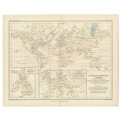
This antique meteorological chart titled "The Distribution of Rain and Snow over the Globe" was created by Alexander Keith Johnston and published in 1852 by William Blackwood & Sons in Edinburgh and London. It is Plate 14 from Johnston’s groundbreaking *Physical Atlas of Natural Phenomena*, a landmark 19th-century atlas that visually documented natural science using elegant cartographic design.
This thematic map represents one of the earliest global attempts to chart patterns of precipitation, displaying how rainfall and snowfall vary according to geography, latitude, topography, and proximity to oceans. The map divides the world into meteorological zones based on the frequency and regularity of rainfall. Shaded bands mark areas of constant equatorial rainfall, seasonal monsoon regions, zones of periodic tropical downpours, and drier arid zones such as the Sahara, Arabian Peninsula, central Australia, and western South America.
The map is annotated with explanatory observations, including statements such as “rains fall only at night and early morning” and “rains accompany heat and decrease with altitude,” reflecting the 19th-century state of meteorological knowledge. Areas with snowfall or extremely low precipitation are also marked, highlighting the climatological variety across continents.
In addition to the main map, the plate includes three detailed diagrams:
* A vertical section comparing snow-line elevations across different mountain ranges worldwide.
* A graph illustrating the relationship between precipitation and temperature.
* A chart showing how rainfall decreases with increasing distance from coastal regions.
Johnston (1804–1871), Geographer in Ordinary to Queen Victoria in Scotland, was among the first to bring natural science into the visual domain through cartography. His *Physical Atlas* is considered one of the most influential works of 19th-century thematic mapping, and this plate is a remarkable example of its ambition and execution.
This print offers collectors and scholars a glimpse into early meteorological theory and global climatology. Its elegant engraving and carefully hand-colored zones also make it an attractive decorative item for libraries, offices, and scientific interiors.
Condition and framing tips:
Good condition with light toning and mild signs of age near the edges. Printed surface clean and crisp. Best framed in dark wood or matte black with a neutral or parchment mat to bring out the warm tonal shading of the climatic zones. A refined and thought-provoking piece for any natural science or vintage cartography collection.
- Dimensions:Hauteur : 27,4 cm (10,79 po)Largeur : 34,5 cm (13,59 po)Profondeur : 0,2 mm (0,01 po)
- Matériaux et techniques:
- Lieu d'origine:
- Période:
- Date de fabrication:1852
- État:Very good condition. Light overall toning near the margins. The paper remains strong and well-preserved. Folding line as issued.
- Adresse du vendeur:Langweer, NL
- Numéro de référence:Vendeur : BG-13207-141stDibs : LU3054345393472
À propos du vendeur
5,0
Vendeur reconnu
Ces vendeurs prestigieux sont des leaders du secteur. Ils représentent le summum en matière de qualité et de design.
Vendeur Platine
Vendeurs premium dont la note est supérieure à 4,7 et le délai de réponse de 24 heures maximum
Établi en 2009
Vendeur 1stDibs depuis 2017
2 647 ventes sur 1stDibs
Temps de réponse habituel : <1 heure
- ExpéditionRecherche du devis...Expédition depuis : Langweer, Pays-Bas
- Politique des retours
Certaines parties de cette page ont été traduites automatiquement. 1stDibs ne garantit pas l'exactitude des traductions. L'anglais est la langue par défaut de ce site web.
Garantie d'authenticité
Bien qu'il soit peu probable que la situation se présente, dans le cas où vous rencontreriez un problème d'authenticité d'un article, contactez-nous dans un délai d'un an pour obtenir un remboursement intégral. DétailsGarantie de remboursement
Si votre article n'est pas conforme à la description, est endommagé pendant le transport ou ne vous est pas livré, contactez-nous sous 7 jours pour obtenir un remboursement intégral. DétailsAnnulation sous 24 heures
Vous disposez d'un délai de 24 heures pour annuler votre achat sans motif.Des vendeurs professionnels agréés
Nos vendeurs de renommée mondiale doivent respecter des normes strictes en matière de service et de qualité, afin de préserver l'intégrité de nos fiches produit.Garantie d'alignement des prix
Si vous constatez qu'un autre vendeur a mis en vente le même article à un prix inférieur sur un autre site, nous nous alignerons sur ce prix.Livraison en toute confiance à l'international
Notre réseau de transporteurs de premier ordre propose des options d'expédition spécialisées dans le monde entier, y compris des livraisons personnalisées.Plus d'articles de ce vendeur
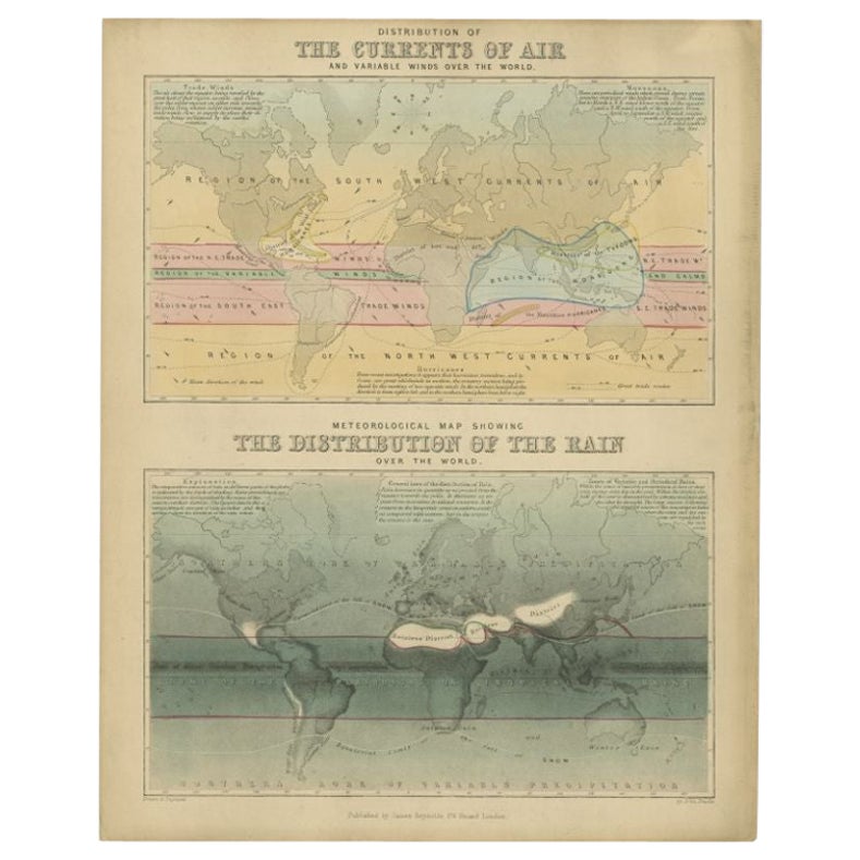
Tout afficherCarte ancienne de la distribution de l'air et de la pluie par Reynolds, 1843
Deux cartes du monde anciennes sur une seule feuille. La carte supérieure montre la répartition des courants d'air et des vents variables dans le monde. La carte météorologique infér...
Catégorie
Antiquités, XIXe siècle, Cartes
Matériaux
Papier
143 € Prix de vente
20 % de remise
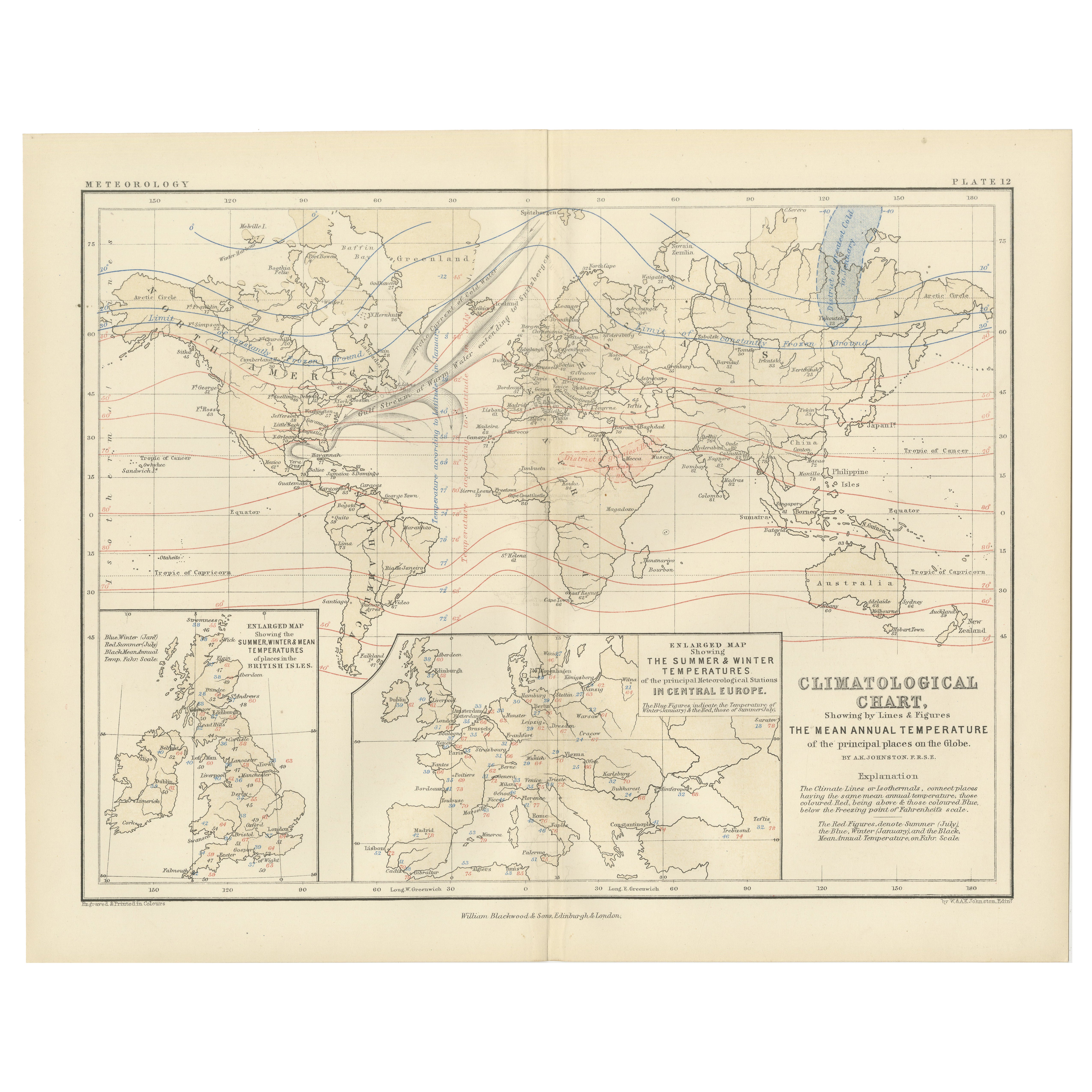
Climatological Map by A.K. Johnston – Global Temperatures Chart 1852
Climatological Map by A.K. Johnston – Global Temperatures Chart 1852
This exceptional antique map titled "Climatological Chart Showing by Lines & Figures the Mean Annual Temperature...
Catégorie
Antiquités, Milieu du XIXe siècle, Écossais, Estampes
Matériaux
Papier
Carte de la pluie ancienne du monde par Johnston '1850'
Carte ancienne intitulée "Hyetographic or Rain Map of the World". Carte de pluie ancienne originale du monde. Cette carte provient de "The Physical Atlas of Natural Phenomena" d'A.K....
Catégorie
Antiquités, Milieu du XIXe siècle, Cartes
Matériaux
Papier

160 € Prix de vente
20 % de remise
Wind and Hurricane Map by A.K. Johnston – Meteorological Chart 1852
Wind and Hurricane Map by A.K. Johnston – Meteorological Chart 1852
This scientifically significant 1852 map titled "The Distribution of the Constant, Periodical & Variable Winds Ov...
Catégorie
Antiquités, Milieu du XIXe siècle, Écossais, Estampes
Matériaux
Papier

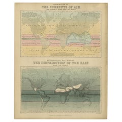
Carte de l'Europe par Johnston '1850'
Carte ancienne intitulée "Hyetographic or Rain Map of Europe". Carte originale ancienne de l'Europe. Cette carte est tirée de "The Physical Atlas of Natural Phenomena" (L'Atlas physi...
Catégorie
Antiquités, Milieu du XIXe siècle, Cartes
Matériaux
Papier

160 € Prix de vente
20 % de remise
Carte ancienne du monde montrant la distribution des plantes et des minéraux, 1872
Carte ancienne intitulée "Johnson's World showing the distribution of the Characteristic Forest Trees (...)". Carte du monde originale montrant la répartition des plantes et des miné...
Catégorie
Antiquités, Fin du XIXe siècle, Cartes
Matériaux
Papier

160 € Prix de vente
20 % de remise
Suggestions
Carte du monde - Gravure originale - 1820
Carte du monde est une gravure originale réalisée par un artiste inconnu du 19ème siècle en 1820.
Très bon état sur deux feuilles de papier blanc j...
Catégorie
années 1820, Moderne, Estampes - Figuratif
Matériaux
Eau-forte

Hemisphere Of The New Continent - Ancienne carte de J.G. Heck - 1834.
Par Johann Georg Heck
Hémisphère du Nouveau Continent est une œuvre d'art réalisée vers 1760 par Johann Georg Heck
Tirage original en couleur.
Bon état, à l'exception du jaunissement du papier et des d...
Catégorie
années 1830, Moderne, Estampes - Figuratif
Matériaux
Eau-forte

487 € Prix de vente
25 % de remise
Planisphere originale illustrée - Carte du monde - Géographie, 1864
Plongez dans l'épopée du passé avec le Planisphère historique illustré de 1864 par Charpentier ! 🗺️ Ce trésor cartographique vous transporte dans les méandres de l'histoire, avec de...
Catégorie
années 1860, Estampes et éditions
Matériaux
Lin, Lithographie, Papier

Carte originale et ancienne du monde par Thomas Clerk, 1817
Grande carte des hémisphères oriental et occidental
Sur 2 feuilles
Gravure sur cuivre
Dessiné et gravé par Thomas Clerk, Édimbourg.
Publié par Mackenzie et Dent, 1817
...
Catégorie
Antiquités, années 1810, Anglais, Cartes
Matériaux
Papier

Carte de l'Empire britannique ancien - Carte ancienne de Karl Spruner - 1760 environ
Par Karl Spruner von Merz
Old British Empire Map est une œuvre d'art réalisée vers 1760 par Karl Spruner.
Épreuve originale colorée à la main.
Bon état sauf un jaunissement du papier le long de la marge, et...
Catégorie
années 1760, Moderne, Estampes - Figuratif
Matériaux
Eau-forte

210 € Prix de vente
25 % de remise
Carte du monde originale et ancienne par Dower, vers 1835
Belle carte du monde
Dessiné et gravé par J.Dower
Publié par Orr & Smith. C.1835
Non encadré.
Expédition gratuite
Catégorie
Antiquités, années 1830, Anglais, Cartes
Matériaux
Papier
