Articles similaires à Wind and Hurricane Map by A.K. Johnston – Meteorological Chart 1852


Vous voulez plus d'images ou de vidéos ?
Demander au vendeur plus d'images ou de vidéos
1 sur 10
Wind and Hurricane Map by A.K. Johnston – Meteorological Chart 1852
260 €par article|TVA incluse
Quantité
À propos de cet article
Wind and Hurricane Map by A.K. Johnston – Meteorological Chart 1852
This scientifically significant 1852 map titled "The Distribution of the Constant, Periodical & Variable Winds Over the Globe and the Regions Visited by Storms & Hurricanes" was produced by Alexander Keith Johnston and published by William Blackwood & Sons, Edinburgh and London. Issued as Plate 13 from Johnston’s acclaimed *Physical Atlas of Natural Phenomena*, this chart represents one of the earliest comprehensive visualizations of global wind patterns and storm activity.
The map displays worldwide atmospheric circulation zones, including the trade winds, westerlies, monsoons, and polar winds. Shaded areas and directional arrows show the dominant wind flows across latitudes, while regions of calms, such as the doldrums and horse latitudes, are clearly marked. The map is divided into latitudinal climate bands, offering a framework that reveals how wind systems vary seasonally and geographically.
Particularly notable are the detailed insets at the bottom, which highlight:
* The course of the Rodriguez hurricane on 13 April 1843.
* Seasonal monsoon shifts in the Indian Ocean.
* The pattern of hurricanes in the West Indies.
* Zones of equatorial and subtropical wind divergence.
These inset diagrams combine observational data with early meteorological theory, helping to explain how storms originate and travel—an especially important concept during an era of global exploration and colonial maritime trade.
Alexander Keith Johnston (1804–1871), Geographer in Ordinary to Queen Victoria in Scotland, was a key figure in the evolution of thematic mapping. His *Physical Atlas* was groundbreaking for its use of visual language to communicate complex environmental and scientific information. The map remains an important historical document in the study of meteorology and global climatology.
This plate will appeal to collectors of early scientific prints, maritime history enthusiasts, and decorators seeking atmospheric, vintage cartographic works.
Condition and framing tips:
Very good condition with minor age toning and original centerfold as issued. Printed area clean and well preserved. Frame in a classic dark wood or black frame with an ivory, parchment, or pale tan mat to enhance the warm earth tones and precise linework. A unique and intelligent addition to a study, library, or natural history-themed space.
- Dimensions:Hauteur : 27,4 cm (10,79 po)Largeur : 34,5 cm (13,59 po)Profondeur : 0,2 mm (0,01 po)
- Matériaux et techniques:
- Lieu d'origine:
- Période:
- Date de fabrication:1852
- État:Very good condition. Light overall toning near the margins. The paper remains strong and well-preserved. Folding line as issued.
- Adresse du vendeur:Langweer, NL
- Numéro de référence:Vendeur : BG-13207-131stDibs : LU3054345393452
À propos du vendeur
5,0
Vendeur reconnu
Ces vendeurs prestigieux sont des leaders du secteur. Ils représentent le summum en matière de qualité et de design.
Vendeur Platine
Vendeurs premium dont la note est supérieure à 4,7 et le délai de réponse de 24 heures maximum
Établi en 2009
Vendeur 1stDibs depuis 2017
2 641 ventes sur 1stDibs
Temps de réponse habituel : <1 heure
- ExpéditionRecherche du devis...Expédition depuis : Langweer, Pays-Bas
- Politique des retours
Certaines parties de cette page ont été traduites automatiquement. 1stDibs ne garantit pas l'exactitude des traductions. L'anglais est la langue par défaut de ce site web.
Garantie d'authenticité
Bien qu'il soit peu probable que la situation se présente, dans le cas où vous rencontreriez un problème d'authenticité d'un article, contactez-nous dans un délai d'un an pour obtenir un remboursement intégral. DétailsGarantie de remboursement
Si votre article n'est pas conforme à la description, est endommagé pendant le transport ou ne vous est pas livré, contactez-nous sous 7 jours pour obtenir un remboursement intégral. DétailsAnnulation sous 24 heures
Vous disposez d'un délai de 24 heures pour annuler votre achat sans motif.Des vendeurs professionnels agréés
Nos vendeurs de renommée mondiale doivent respecter des normes strictes en matière de service et de qualité, afin de préserver l'intégrité de nos fiches produit.Garantie d'alignement des prix
Si vous constatez qu'un autre vendeur a mis en vente le même article à un prix inférieur sur un autre site, nous nous alignerons sur ce prix.Livraison en toute confiance à l'international
Notre réseau de transporteurs de premier ordre propose des options d'expédition spécialisées dans le monde entier, y compris des livraisons personnalisées.Plus d'articles de ce vendeur
Tout afficherCarte ancienne montrant la distribution des courants d'air par Johnston '1850'
Carte ancienne intitulée "Distribution géographique des courants d'air". Carte ancienne originale montrant la répartition des courants d'air. Cette carte provient de "The Physical At...
Catégorie
Antiquités, Milieu du XIXe siècle, Cartes
Matériaux
Papier

160 € Prix de vente
20 % de remise
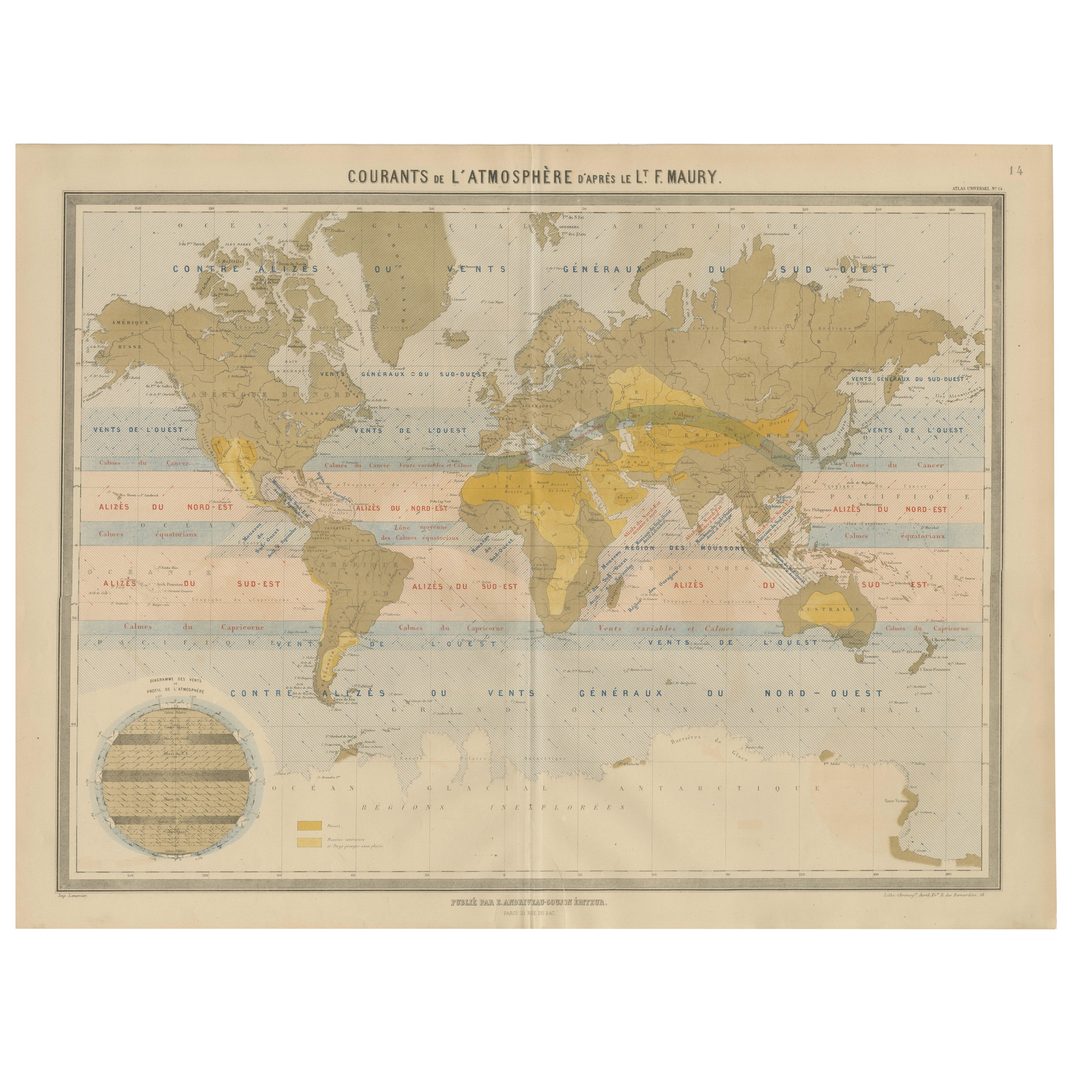
Carte mondiale des courants de vent - "Courants de l'Atmosphère" par Andriveau-Goujon, 1861
Carte mondiale des courants de vent - "Courants de l'Atmosphère" par Andriveau-Goujon, 1861
Cette carte ancienne, remarquable et éducative, intitulée "Courants de l'Atmosphère d'apr...
Catégorie
Antiquités, Milieu du XIXe siècle, Français, Cartes
Matériaux
Papier

Carte ancienne montrant les lignes d'Isotherm dans le monde entier par Johnston '1850'
Carte ancienne intitulée "Système de lignes isothermes de Humboldt". Carte ancienne originale montrant les lignes d'isothermes à travers le monde. Cette carte est tirée de "The Physi...
Catégorie
Antiquités, Milieu du XIXe siècle, Cartes
Matériaux
Papier

160 € Prix de vente
20 % de remise
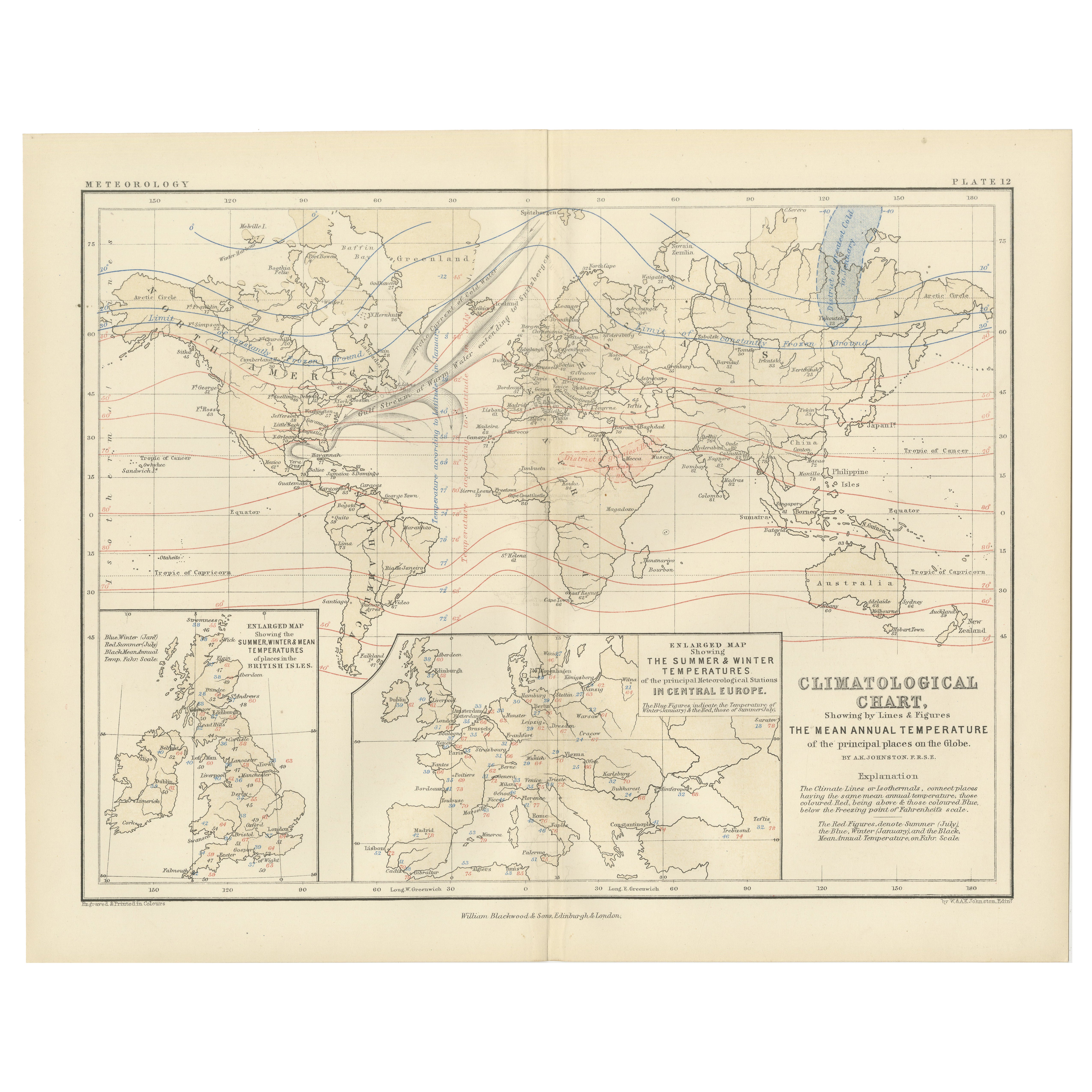
Climatological Map by A.K. Johnston – Global Temperatures Chart 1852
Climatological Map by A.K. Johnston – Global Temperatures Chart 1852
This exceptional antique map titled "Climatological Chart Showing by Lines & Figures the Mean Annual Temperature...
Catégorie
Antiquités, Milieu du XIXe siècle, Écossais, Estampes
Matériaux
Papier
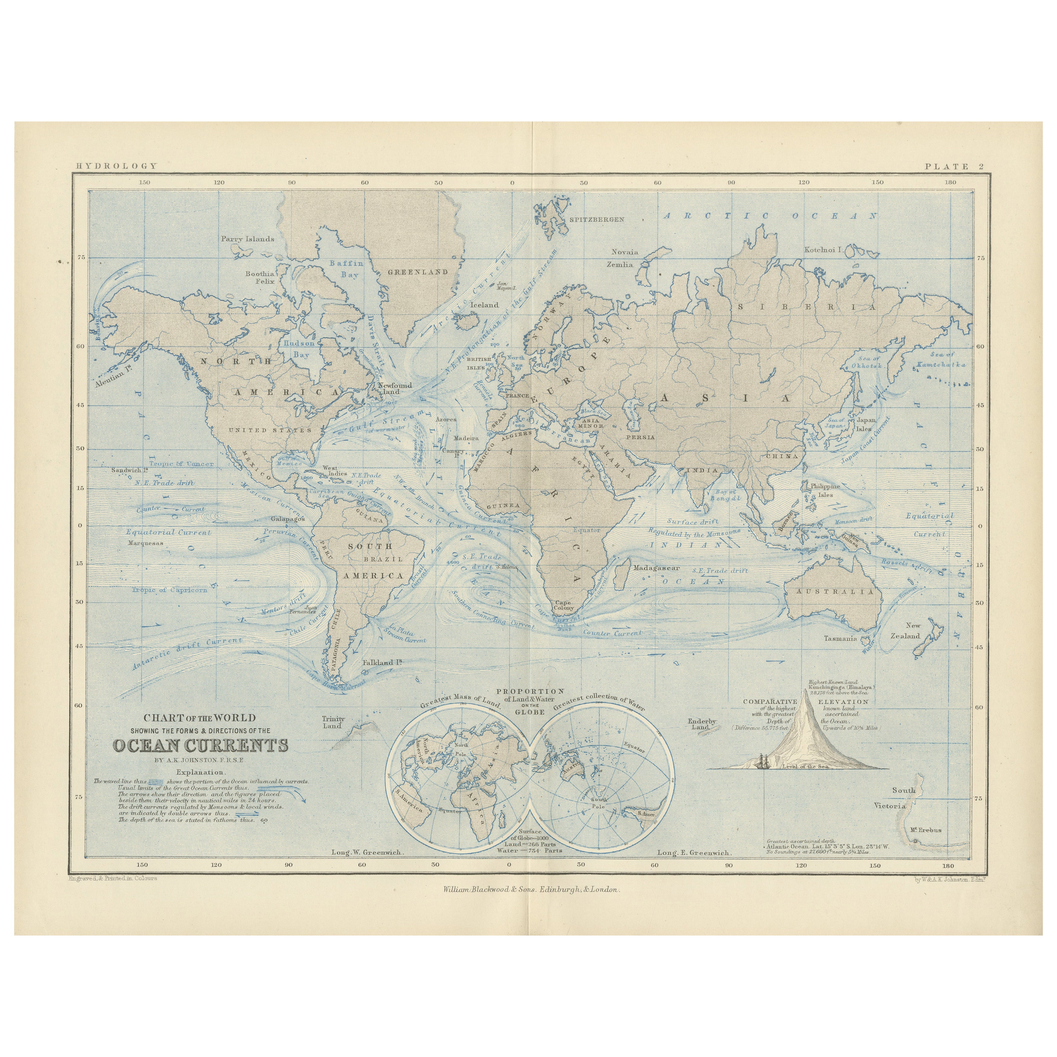
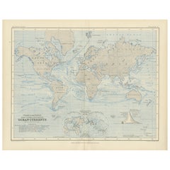
World Map of Ocean Currents by A.K. Johnston, Educational Print 1852
World Map of Ocean Currents by A.K. Johnston, Educational Print 1852
This detailed and scientifically rich chart titled 'Chart of the World Showing the Form & Direction of the Ocean...
Catégorie
Antiquités, Milieu du XIXe siècle, Écossais, Estampes
Matériaux
Papier
Carte ancienne montrant les courants océaniques et la température de l'air, '1872'
Deux cartes sur une feuille intitulées 'Johnson's Oceans Currents (...)' et 'Johnson's World showing the Distribution of the Temperature of the Air'. Carte du monde originale montran...
Catégorie
Antiquités, Fin du XIXe siècle, Cartes
Matériaux
Papier

280 € Prix de vente
20 % de remise
Suggestions
Carte ancienne originale de l'hémisphère occidental par Dower, vers 1835
Belle carte de l'hémisphère occidental
Dessiné et gravé par J.Dower
Publié par Orr & Smith. C.1835
Non encadré.
Expédition gratuite
Catégorie
Antiquités, années 1830, Anglais, Cartes
Matériaux
Papier

Planisphere originale illustrée - Carte du monde - Géographie, 1864
Plongez dans l'épopée du passé avec le Planisphère historique illustré de 1864 par Charpentier ! 🗺️ Ce trésor cartographique vous transporte dans les méandres de l'histoire, avec de...
Catégorie
années 1860, Estampes et éditions
Matériaux
Lin, Lithographie, Papier

Hemisphere Of The New Continent - Ancienne carte de J.G. Heck - 1834.
Par Johann Georg Heck
Hémisphère du Nouveau Continent est une œuvre d'art réalisée vers 1760 par Johann Georg Heck
Tirage original en couleur.
Bon état, à l'exception du jaunissement du papier et des d...
Catégorie
années 1830, Moderne, Estampes - Figuratif
Matériaux
Eau-forte

487 € Prix de vente
25 % de remise
Carte du monde originale et ancienne par Dower, vers 1835
Belle carte du monde
Dessiné et gravé par J.Dower
Publié par Orr & Smith. C.1835
Non encadré.
Expédition gratuite
Catégorie
Antiquités, années 1830, Anglais, Cartes
Matériaux
Papier

Carte ancienne originale de l'hémisphère oriental par Dower, vers 1835
Belle carte de l'hémisphère oriental
Dessiné et gravé par J.Dower
Publié par Orr & Smith. C.1835
Non encadré.
Expédition gratuite
Catégorie
Antiquités, années 1830, Anglais, Cartes
Matériaux
Papier

Carte originale et ancienne du monde par Thomas Clerk, 1817
Grande carte des hémisphères oriental et occidental
Sur 2 feuilles
Gravure sur cuivre
Dessiné et gravé par Thomas Clerk, Édimbourg.
Publié par Mackenzie et Dent, 1817
...
Catégorie
Antiquités, années 1810, Anglais, Cartes
Matériaux
Papier
