Articles similaires à Carte du sud du Portugal du 17e siècle par Sanson - coloriée à la main, 1679


Vous voulez plus d'images ou de vidéos ?
Demander au vendeur plus d'images ou de vidéos
1 sur 10
Carte du sud du Portugal du 17e siècle par Sanson - coloriée à la main, 1679
À propos de cet article
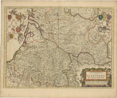
17th Century Map of Southern Portugal by Sanson – Hand-Colored, 1679
This stunning 1679 map of Portugal offers a captivating glimpse into the past, showcasing the country's geography as it was understood over three centuries ago. Spanning the entire western coast of the Iberian Peninsula, the map meticulously details regions such as Entre Douro e Minho, Beira, Estremadura, Alentejo, and the Algarve, each delineated with vibrant yellow and green borders. The Atlantic Ocean, labeled as "Oceano de Portugal" and "Tugal," frames the western edge, while the Gulf of Cadiz graces the southern boundary, adding a nautical allure to the composition. Intricate place names like Lisbon, Setubal, and Evora are scattered across the landscape, accompanied by a network of rivers, mountains, and towns, all rendered in delicate hand-colored lines and shading.
What makes this print particularly intriguing is its historical context and artistic execution. Created in an era when cartography was both a science and an art form, the map reflects the knowledge and exploration of the time, with some regions depicted with a charmingly approximate accuracy. The ornate cartouche in the upper right corner, adorned with a decorative drape and title "Parte Meridional do Reyno de Portugal," serves as a focal point, hinting at the map's royal patronage and its purpose as both a functional tool and a decorative piece. Red dots marking key locations add a touch of visual interest, drawing the eye across the terrain.
The map depicts the southern portion of Portugal, including:
Lisbon (Lisbonne) and the surrounding regions like Setúbal, Alentejo (ALEN), and the Ribatejo.
The Algarve region at the bottom, labeled "Reino do Algarve".
Border regions of Spain such as Andalusia and Extremadura.
Major rivers like the Tejo (Tagus) and Guadiana are prominently shown.
Cities such as Évora, Beja, Faro, Tavira, and Portalegre are labeled.
Coastal features like Cabo de São Vicente and Golfo de Cádiz are identified.
For a potential buyer, this map is a treasure trove of historical insight and aesthetic appeal. It offers a window into 18th-century Portugal, a period of maritime prowess and cultural richness, making it an ideal addition to a collection of antique maps or a study of European history. The aged parchment texture, combined with the hand-colored details, lends an authentic antique charm that modern reproductions struggle to replicate. Whether displayed in a study, library, or gallery, this map promises to spark conversations and admiration, blending educational value with timeless elegance.
Condition Summary
The print is in fair condition for its age, with some expected wear. There are no significant visible tears or losses, but a weaker area has been supported with archival tape on the reverse. The hand-colored elements remain vivid, and the text is legible, preserving the map's historical integrity.
Framing Tips
To preserve and showcase this print effectively, use acid-free matting and backing to protect the paper from further deterioration. A simple, elegant wooden frame in a neutral tone like walnut or oak will complement the map's antique style without overpowering it. Ensure the frame size allows for a generous border around the map to highlight its detailed edges and cartouche. Hang the print in a location away from direct sunlight and humidity to maintain its condition over time.
- Dimensions:Hauteur : 42,5 cm (16,74 po)Largeur : 57 cm (22,45 po)Profondeur : 0,2 mm (0,01 po)
- Matériaux et techniques:Papier,Gravé
- Lieu d'origine:
- Période:Fin du XVIIe siècle
- Date de fabrication:1679
- État:The print is in fair condition for its age, with some expected wear. There are no significant visible tears or losses, but a weaker area has been supported with archival tape on the reverse. The hand-colored elements remain vivid.
- Adresse du vendeur:Langweer, NL
- Numéro de référence:Vendeur : BG-14068-21stDibs : LU3054345401102
À propos du vendeur
5,0
Vendeur reconnu
Ces vendeurs prestigieux sont des leaders du secteur. Ils représentent le summum en matière de qualité et de design.
Vendeur Or
Vendeurs premium dont la note est supérieure à 4,3 et le délai de réponse de 24 heures maximum
Établi en 2009
Vendeur 1stDibs depuis 2017
2 469 ventes sur 1stDibs
Temps de réponse habituel : <1 heure
- ExpéditionRecherche du devis...Expédition depuis : Langweer, Pays-Bas
- Politique des retours
Certaines parties de cette page ont été traduites automatiquement. 1stDibs ne garantit pas l'exactitude des traductions. L'anglais est la langue par défaut de ce site web.
Garantie d'authenticité
Bien qu'il soit peu probable que la situation se présente, dans le cas où vous rencontreriez un problème d'authenticité d'un article, contactez-nous dans un délai d'un an pour obtenir un remboursement intégral. DétailsGarantie de remboursement
Si votre article n'est pas conforme à la description, est endommagé pendant le transport ou ne vous est pas livré, contactez-nous sous 7 jours pour obtenir un remboursement intégral. DétailsAnnulation sous 24 heures
Vous disposez d'un délai de 24 heures pour annuler votre achat sans motif.Des vendeurs professionnels agréés
Nos vendeurs de renommée mondiale doivent respecter des normes strictes en matière de service et de qualité, afin de préserver l'intégrité de nos fiches produit.Garantie d'alignement des prix
Si vous constatez qu'un autre vendeur a mis en vente le même article à un prix inférieur sur un autre site, nous nous alignerons sur ce prix.Livraison en toute confiance à l'international
Notre réseau de transporteurs de premier ordre propose des options d'expédition spécialisées dans le monde entier, y compris des livraisons personnalisées.Plus d'articles de ce vendeur
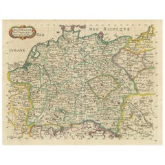
Tout afficherCarte décorative d'Allemagne colorée à la main par Nicolas Sanson, 1648
Titre : Carte d'Allemagne coloriée à la main par Nicolas Sanson, 1648
Cette carte coloriée à la main, intitulée "Allemagne", a été créée par Nicolas Sanson, un éminent cartographe f...
Catégorie
Antiquités, 1640, Cartes
Matériaux
Papier
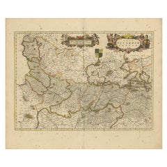
Carte de la Picardie - Gravure du XVIIe siècle coloriée à la main par Frederik De Wit c. 1688
Titre : Carte de la Picardie - Gravure à la main du 17e siècle de Frederik De Wit c. 1688
Description : Cette carte magnifiquement détaillée, "Nova Picardiae Tabula", illustre la ré...
Catégorie
Antiquités, 1680, Cartes
Matériaux
Papier
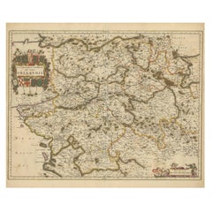
Carte ancienne de Roermond et du Duché de Gueldre par Sanson - coloriée à la main, c.1667
Antique map of Roermond and the Duchy of Guelders with rich detail, c.1667
This beautifully hand-colored 17th-century map presents the region of Roermond and the broader Duchy of Gu...
Catégorie
Antiquités, Fin du XVIIe siècle, Français, Cartes
Matériaux
Papier
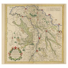
Carte de l'Orléanais en France colorée à la main au 17e siècle par Frederik De Wit c. 1688
Titre : Carte de l'Orléanais du XVIIe siècle coloriée à la main par Frederik De Wit c. 1688
Description : Cette magnifique carte, intitulée "Gouvernement général du Pays orléanais",...
Catégorie
Antiquités, 1680, Cartes
Matériaux
Papier
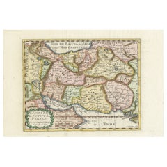
Carte de l'Empire perse par Nicolas Sanson, coloriée à la main, vers 1683
Carte de l'Empire perse par Nicolas Sanson, coloriée à la main, vers 1683
Cette carte finement détaillée et délicatement colorée à la main, intitulée *L'Empire du Sophy des Perses*,...
Catégorie
Antiquités, 1680, Cartes
Matériaux
Papier
Carte de la Gascogne et de la Guyenne - Gravure du XVIIe siècle coloriée à la main par De Wit, c.1688
Titre : Carte de la Gascogne et de la Guyenne - Gravure du XVIIe siècle coloriée à la main par Frederik De Wit c. 1688
Description : Cette remarquable carte, "Gouvernement de la Guy...
Catégorie
Antiquités, 1680, Cartes
Matériaux
Papier
Suggestions
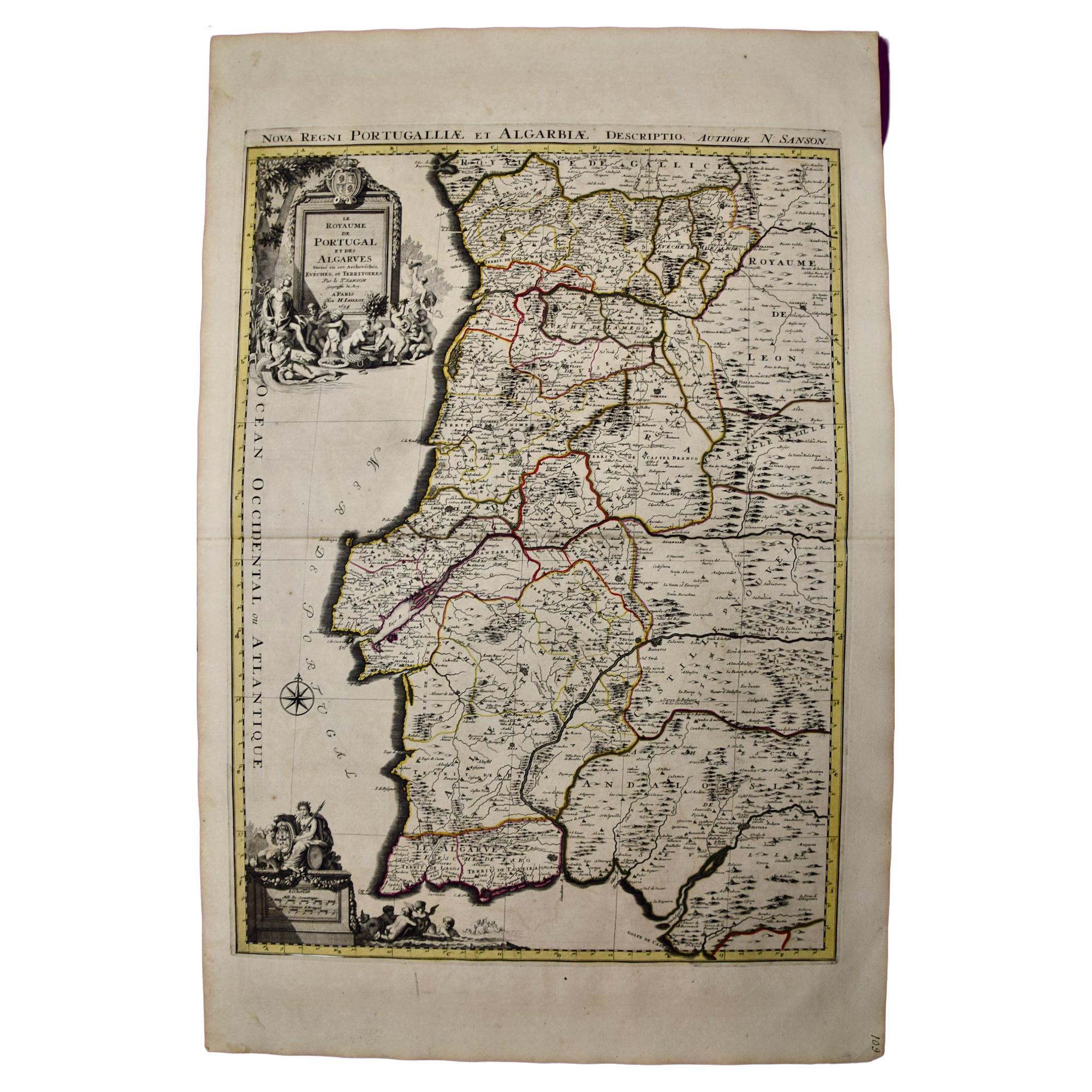
Portugal : Grande carte du 17ème siècle colorée à la main par Sanson et Jaillot
Par Nicolas Sanson
Cette grande carte coloriée à la main intitulée "Le Royaume de Portugal et des Algarves Divisee en see Archeveches, Eveches et Territoires Par le Sr Sanson" a été créée à l'origine p...
Catégorie
Antiquités, 1690, Français, Cartes
Matériaux
Papier

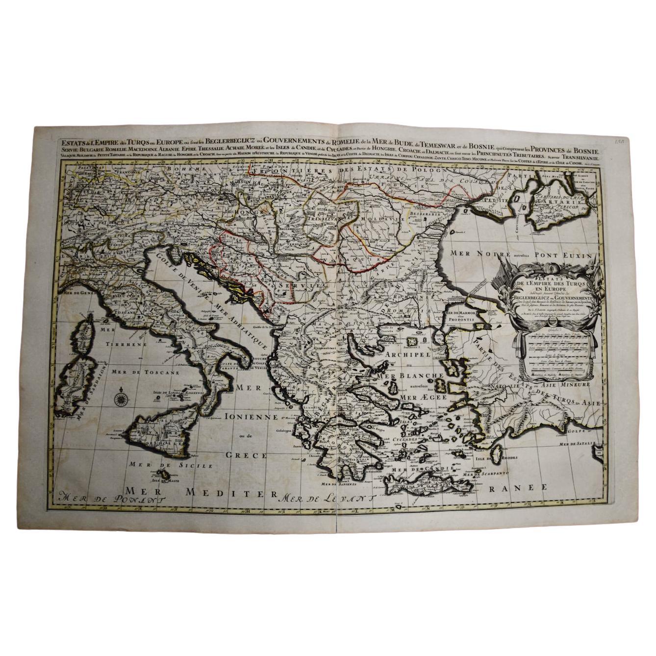
Europe du Sud et de l'Est : Une grande carte du C.I.C. colorée à la main par Sanson & Jaillot
Par Nicolas Sanson
Cette grande carte coloriée à la main intitulée "Estats de L'Empire des Turqs en Europe, ou sont les Beglerbeglicz our Gouvernements" a été créée à l'origine par Nicholas Sanson d'Ab...
Catégorie
Antiquités, 1690, Français, Cartes
Matériaux
Papier

Grèce du Sud : Grande carte du XVIIe siècle colorée à la main par Sanson et Jaillot
Par Nicolas Sanson
Cette grande carte originale gravée sur cuivre et colorée à la main du sud de la Grèce et de la péninsule du Péloponnèse, intitulée "La Moree Et Les Isles De Zante, Cefalonie, Ste. M...
Catégorie
Antiquités, 1690, Français, Cartes
Matériaux
Papier

« African Vetus » : une carte colorée à la main du 17e siècle par Sanson
Par Nicolas Sanson
Cette carte originale de l'Afrique, gravée sur cuivre et colorée à la main, intitulée "Africa Vetus, Nicolai Sanson Christianiss Galliar Regis Geographi", a été créée par Nicholas Sa...
Catégorie
Antiquités, Fin du XVIIe siècle, Français, Cartes
Matériaux
Papier

Grèce, "Graeciae Antiquae""" Une carte du 17ème siècle colorée à la main par Sanson
Par Nicolas Sanson
Il s'agit d'une carte originale de la Grèce du XVIIe siècle, gravée sur cuivre et colorée à la main, intitulée "Graeciae Antiquae Tabula Hanc Geographicam" par Nicolas d'Abbeville Sa...
Catégorie
Antiquités, Milieu du XVIIe siècle, Français, Cartes
Matériaux
Papier

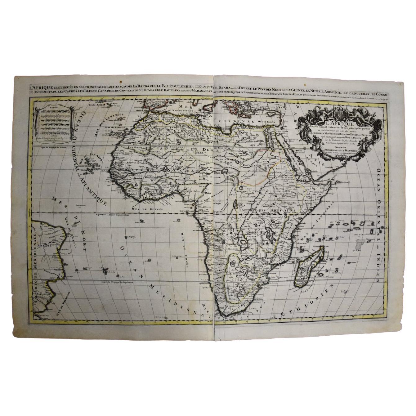
Afrique : une grande carte colorée à la main du 17ème siècle par Sanson et Jaillot
Par Nicolas Sanson
Cette grande carte originale de l'Afrique, gravée sur cuivre et colorée à la main, intitulée "L'Afrique divisée suivant l'estendue de ses principales parties ou sont distinguées les ...
Catégorie
Antiquités, 1690, Français, Cartes
Matériaux
Papier
