Articles similaires à 1896 "Territory of Arizona" Map, Published by the General Land Office


Vous voulez plus d'images ou de vidéos ?
Demander au vendeur plus d'images ou de vidéos
1 sur 5
1896 "Territory of Arizona" Map, Published by the General Land Office
À propos de cet article
Presented is an attractive "Territory of Arizona” map, from the “Report of the Governor of Arizona to the Secretary of the Interior." First published in 1894, this 1896 edition was revised and reconstructed by R. H. Morton and published by the General Land Office, based on “official Records of the General Land Office and other sources under the supervision of Harry King, C.E.” The report gave extensive detail regarding the territory’s population, including Native Americans of Arizona, the agriculture, mining, taxation, banks, transportation, immigration and tourism, as well as the current challenges to the territory’s development. This beautifully colored and highly detailed map was bound in the back of the 142 page Report. The map was lettered by M. Hendges and R.M. Towson.
The map is outlined by county in pink and detailed in black, with town names, roads, wagon roads, railroads, and mountains labeled. Intricate brown hachured mountain areas and the blue waterways combine to provide great visual impact. The map shows the extent of nine Indian reservations, outlined in green, and at least four military reservations, including Fort Apache, colored in solid red. The Grand Canyon is also shown and labeled as a Forest Reserve in pale pink. Any private land claims, confirmed and unconfirmed, are outlined in red, while townships not yet subdivided are identified with a circled cross.
Arizona, formerly part of the Territory of New Mexico, was organized as a separate territory on February 24, 1863. The United States acquired the region under the terms of the 1848 Treaty of Guadalupe Hidalgo and the 1853 Gadsden Purchase.
In the 1870s and 1880s, particularly after the arrival of the railroad in 1880, the population of the Arizona Territory expanded rapidly. With many Native American tribes relocated to reservations, white settlers drawn by the rich agricultural and mineral resources arrived in the region. Gold was discovered in 1863 near the first capital, Prescott. The 1877 discoveries of silver at Tombstone, near Tucson, and copper at Bisbee, also brought many settlers hoping to strike it rich. Many Mormon settlers moved south from Utah and Mexicans emigrated north. The flow of European emigrants also increased markedly thanks to the railroad. By the beginning of the 20th century, the population of the Arizona Territory exceeded 100,000. As the population grew, there was increasing sentiment for statehood, which was finally granted in 1912.
CONDITION:
Very good condition. Lithographed folding map, printed with original color. Map paper is lightly toned, color is strong and attractive. Fold lines, as issued. The map was removed from the original "Report of the Governor of Arizona to the Secretary of the Interior" booklet. Original booklet included. The booklet has red paper covers,142 pages with text and tables describing the territory including immigration, taxation, mining, banks, railroads, and much more. The booklet binding is tight and paper is clean, but the red paper covers have wear and lifting at the spine and a small chip at the right edge on the front cover.
Accompanied by our company's letter of authenticity.
- Dimensions:Hauteur : 73,03 cm (28,75 po)Largeur : 63,5 cm (25 po)Profondeur : 2,54 cm (1 po)
- Matériaux et techniques:
- Période:
- Date de fabrication:1896
- État:Ajouts ou modifications apportés à l'original: Framed according to archival standards by Artem Art Services in Colorado Springs, CO. Usure conforme à l'âge et à l'utilisation.
- Adresse du vendeur:Colorado Springs, CO
- Numéro de référence:Vendeur : M3921stDibs : LU909745349572
À propos du vendeur
4,9
Vendeur Platine
Vendeurs premium dont la note est supérieure à 4,7 et le délai de réponse de 24 heures maximum
Établi en 2010
Vendeur 1stDibs depuis 2011
453 ventes sur 1stDibs
Temps de réponse habituel : 1 heure
- ExpéditionRecherche du devis...Expédition depuis : Colorado Springs, CO
- Politique des retours
Certaines parties de cette page ont été traduites automatiquement. 1stDibs ne garantit pas l'exactitude des traductions. L'anglais est la langue par défaut de ce site web.
Garantie d'authenticité
Bien qu'il soit peu probable que la situation se présente, dans le cas où vous rencontreriez un problème d'authenticité d'un article, contactez-nous dans un délai d'un an pour obtenir un remboursement intégral. DétailsGarantie de remboursement
Si votre article n'est pas conforme à la description, est endommagé pendant le transport ou ne vous est pas livré, contactez-nous sous 7 jours pour obtenir un remboursement intégral. DétailsAnnulation sous 24 heures
Vous disposez d'un délai de 24 heures pour annuler votre achat sans motif.Des vendeurs professionnels agréés
Nos vendeurs de renommée mondiale doivent respecter des normes strictes en matière de service et de qualité, afin de préserver l'intégrité de nos fiches produit.Garantie d'alignement des prix
Si vous constatez qu'un autre vendeur a mis en vente le même article à un prix inférieur sur un autre site, nous nous alignerons sur ce prix.Livraison en toute confiance à l'international
Notre réseau de transporteurs de premier ordre propose des options d'expédition spécialisées dans le monde entier, y compris des livraisons personnalisées.Plus d'articles de ce vendeur
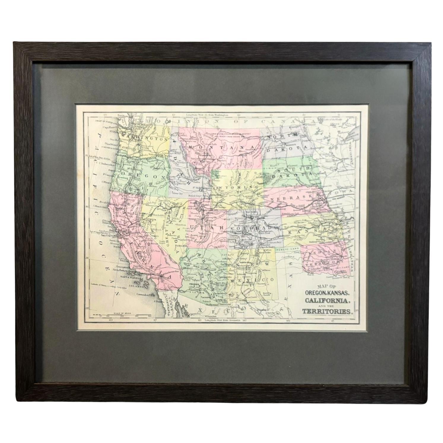
Tout afficher1890 "Carte de l'Oregon, du Kansas, de la Californie et des Territoires" par S. A. Mitchell
Par Samuel Augustus Mitchell 1
La carte présentée est une carte de 1890 intitulée "Map of Oregon, Kansas, California, and the Territories" (Carte de l'Oregon, du Kansas, de la Californie et des territoires) par S....
Catégorie
Antiquités, années 1890, Américain, Victorien, Cartes
Matériaux
Papier

Carte de la ville de Washington publiée par William M. Morrison, 1840
Cette carte, imprimée en 1840, est une représentation détaillée de Washington, C.I.C. au milieu du 19e siècle. La carte montre les numéros d'îlots, les quartiers et les bâtiments gou...
Catégorie
Antiquités, années 1840, Américain, Fédéral, Cartes
Matériaux
Papier

Carte murale des États-Unis de 1842 par J. H. Young, publiée par S. A. Mitchell
Nous présentons une "Carte des États-Unis" suspendue de 1842, gravée par J. H. Young et publiée par Samuel Augustus Mitchell, Philadelphie. Il s'agit d'un bel exemple de la rare édit...
Catégorie
Antiquités, années 1840, Américain, Cartes
Matériaux
Papier

"Taylor et ses généraux":: première édition:: publiée par E. H. Butler & Co.:: 1847
Taylor and his Generals. New York : E.H. Butler & Co., 1847. Première édition. Reliure en demi-cuir et planches de papier marbré. Présenté dans un étui personnalisé.
Nous vous propo...
Catégorie
Antiquités, années 1840, Américain, Livres
Matériaux
Papier

« Map of the United States of America..." de 1859 par J. H. Colton
Par J.H. Colton
La carte présentée est une "Carte des États-Unis d'Amérique, des provinces britanniques, du Mexique, des Antilles et de l'Amérique centrale avec une partie de la Nouvelle-Grenade et ...
Catégorie
Antiquités, années 1850, Américain, Cartes
Matériaux
Papier

Carte ornementale des États-Unis et du Mexique par H. Phelps, 1847
Nous vous proposons une carte ornementale originale des États-Unis de 1847 intitulée "Ornamental Map of the United States & Mexico" (Carte ornementale des États-Unis et du Mexique) p...
Catégorie
Antiquités, années 1840, Américain, Cartes
Matériaux
Papier

Suggestions
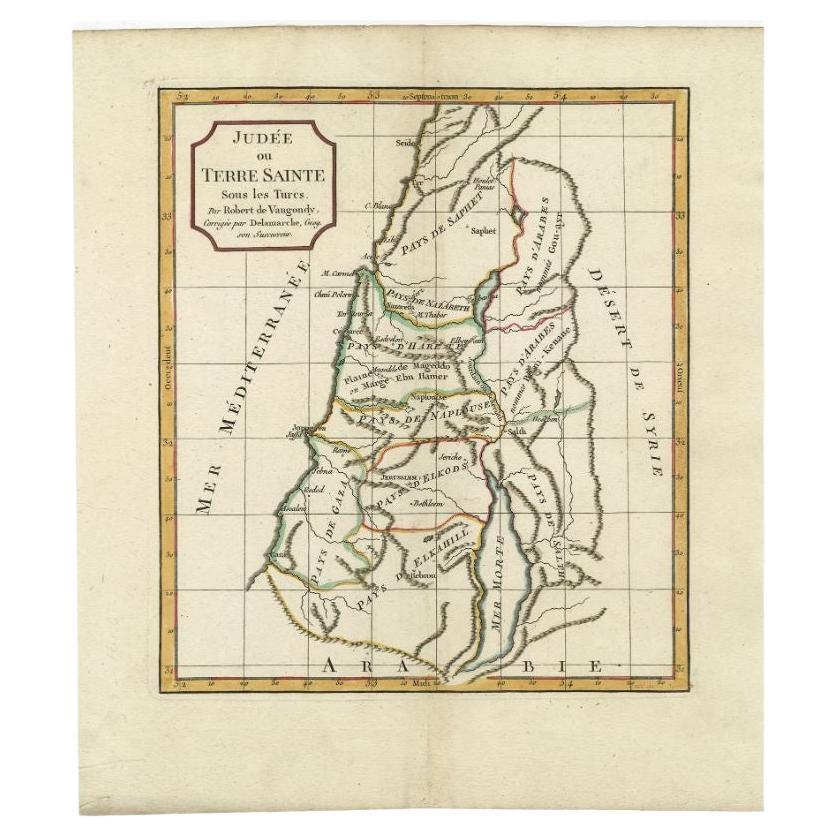
Carte ancienne de la Terre Sainte par Delamarche, 1806
Par Charles Francois Delamarche
Carte ancienne intitulée "Judee ou Terre Sainte sous les Turcs". Cette carte montre la terre sainte sous les Turcs. Par Robert de Vaugondy, révisé et publié par Delamarche. Source in...
Catégorie
Antiquités, XIXe siècle, Cartes
Matériaux
Papier
Carte ancienne de la Terre Sainte par Keur, 1748
Carte ancienne de la Terre Sainte intitulée 'De Gelegentheyd van t'Paradys ende t'Landt Canaan, Mitsgaders d'eerst bewoonde Landen der Patriarchen'. Comprend cinq vignettes décorativ...
Catégorie
Antiquités, XVIIIe siècle, Cartes
Matériaux
Papier

327 $US Prix de vente
20 % de remise
Carte ancienne de la Terre Sainte par Schut, 1710
Carte ancienne de la Terre Sainte intitulée "Het Beloofde Landt Canaan" Carte très détaillée et décorative de la Terre Sainte, agrémentée de voiliers et d'une rose des vents. Texte e...
Catégorie
Antiquités, XVIIIe siècle, Cartes
Matériaux
Papier

395 $US Prix de vente
20 % de remise
Carte ancienne de la Terre Sainte par Danckerts, datant d'environ 1710
Carte ancienne intitulée "Afbeeldinge van de Veertich-Iaarige Reyse der Kinderen Israëls uyt Egypten door de Roode Zee en de Woestyne tot in 't Beloofde Landt Canaan". Carte de la Te...
Catégorie
Antiquités, XVIIIe siècle, Cartes
Matériaux
Papier

336 $US Prix de vente
20 % de remise
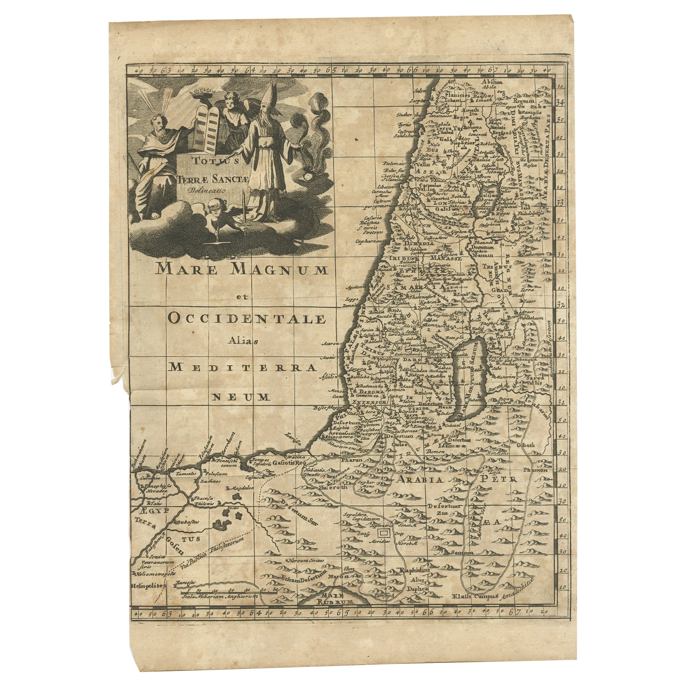
Carte ancienne de la Terre Sainte, vers 1710
Carte ancienne intitulée "Totius Terrae Sanctae Delineatio". Carte de la Terre sainte s'étendant jusqu'à l'Égypte et montrant la route des enfants d'Israël lors de leur exode d'Égypt...
Catégorie
Antiquités, XVIIIe siècle, Cartes
Matériaux
Papier

113 $US Prix de vente
20 % de remise
Carte ancienne de la Terre Sainte, vers 1717
Carte ancienne d'Israël intitulée "Tabula Geographica Terrae Sanctae". Édition rare réalisée d'après une carte de la Terre Sainte par J. Bonfrerius. La carte est orientée avec le nor...
Catégorie
Antiquités, XVIIIe siècle, Cartes
Matériaux
Papier

367 $US Prix de vente
20 % de remise