Articles similaires à Antique Map of Africa, Highlighting Colonial Divisions, Geographic Features 1903


Vous voulez plus d'images ou de vidéos ?
Demander au vendeur plus d'images ou de vidéos
1 sur 10
Antique Map of Africa, Highlighting Colonial Divisions, Geographic Features 1903
À propos de cet article
Title: Antique Map of Africa, 1903, Highlighting Colonial Divisions and Geographic Features
Description: This antique map, titled "Africa," was engraved and published in 1903 by W. & A.K. Johnston in Edinburgh and London. It provides a fascinating and detailed look at the African continent at the height of the colonial era, reflecting the complex interplay of geography, culture, and imperial ambitions.
Hand-colored in soft pastel shades, the map delineates the colonial territories that defined Africa during this period, including the spheres of influence of the British, French, German, Portuguese, Italian, Belgian, and Spanish empires. Major rivers, mountain ranges, and lakes are all clearly depicted, offering a rich geographical context for the colonial boundaries imposed by European powers.
The map’s elegant typography and refined linework capture the grandeur of Africa’s natural features and underscore the political realities of the time. From the Sahara Desert to the fertile Nile basin, from the Cape of Good Hope to the islands of the Indian Ocean, this map illustrates the diverse environments and cultures that make Africa such a dynamic and significant part of the world.
For collectors, historians, and those with an interest in African history, this map is more than a decorative piece—it is a testament to a pivotal period in the continent’s story, reflecting both the beauty of its landscapes and the dramatic changes brought by colonization.
Condition report:
This map is in very good antique condition, with only minor foxing and gentle edge toning typical for its age. The colors remain vibrant and the paper is stable and well-preserved.
Framing tips:
A classic wooden frame in walnut or cherry will enhance the soft pastel colors and historical detail of this map. Use a cream or off-white matting to highlight the refined linework and create a sophisticated, timeless focal point for any home, library, or study.
- Dimensions:Hauteur : 36,8 cm (14,49 po)Largeur : 47 cm (18,51 po)Profondeur : 0,2 mm (0,01 po)
- Matériaux et techniques:
- Période:
- Date de fabrication:1903
- État:This map is in very good antique condition, with only minor foxing and gentle edge toning typical for its age. The colors remain vibrant and the paper is stable and well-preserved.
- Adresse du vendeur:Langweer, NL
- Numéro de référence:Vendeur : BG-13577-351stDibs : LU3054345271972
À propos du vendeur
5,0
Vendeur reconnu
Ces vendeurs prestigieux sont des leaders du secteur. Ils représentent le summum en matière de qualité et de design.
Vendeur Or
Vendeurs premium dont la note est supérieure à 4,3 et le délai de réponse de 24 heures maximum
Établi en 2009
Vendeur 1stDibs depuis 2017
2 463 ventes sur 1stDibs
Temps de réponse habituel : <1 heure
- ExpéditionRecherche du devis...Expédition depuis : Langweer, Pays-Bas
- Politique des retours
Certaines parties de cette page ont été traduites automatiquement. 1stDibs ne garantit pas l'exactitude des traductions. L'anglais est la langue par défaut de ce site web.
Garantie d'authenticité
Bien qu'il soit peu probable que la situation se présente, dans le cas où vous rencontreriez un problème d'authenticité d'un article, contactez-nous dans un délai d'un an pour obtenir un remboursement intégral. DétailsGarantie de remboursement
Si votre article n'est pas conforme à la description, est endommagé pendant le transport ou ne vous est pas livré, contactez-nous sous 7 jours pour obtenir un remboursement intégral. DétailsAnnulation sous 24 heures
Vous disposez d'un délai de 24 heures pour annuler votre achat sans motif.Des vendeurs professionnels agréés
Nos vendeurs de renommée mondiale doivent respecter des normes strictes en matière de service et de qualité, afin de préserver l'intégrité de nos fiches produit.Garantie d'alignement des prix
Si vous constatez qu'un autre vendeur a mis en vente le même article à un prix inférieur sur un autre site, nous nous alignerons sur ce prix.Livraison en toute confiance à l'international
Notre réseau de transporteurs de premier ordre propose des options d'expédition spécialisées dans le monde entier, y compris des livraisons personnalisées.Plus d'articles de ce vendeur
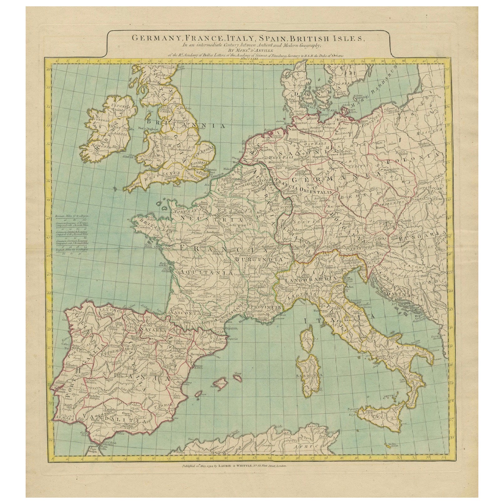
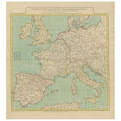
Tout afficherCarte d'Europe mettant en valeur les divisions géographiques anciennes et modernes (1794)
Carte de l'Europe mettant en évidence les divisions géographiques anciennes et modernes (1794). Allemagne, France, Italie, Espagne et îles britanniques - Carte de D'Anville (1794).
...
Catégorie
Antiquités, années 1790, Cartes
Matériaux
Papier
1 572 $US Prix de vente
20 % de remise
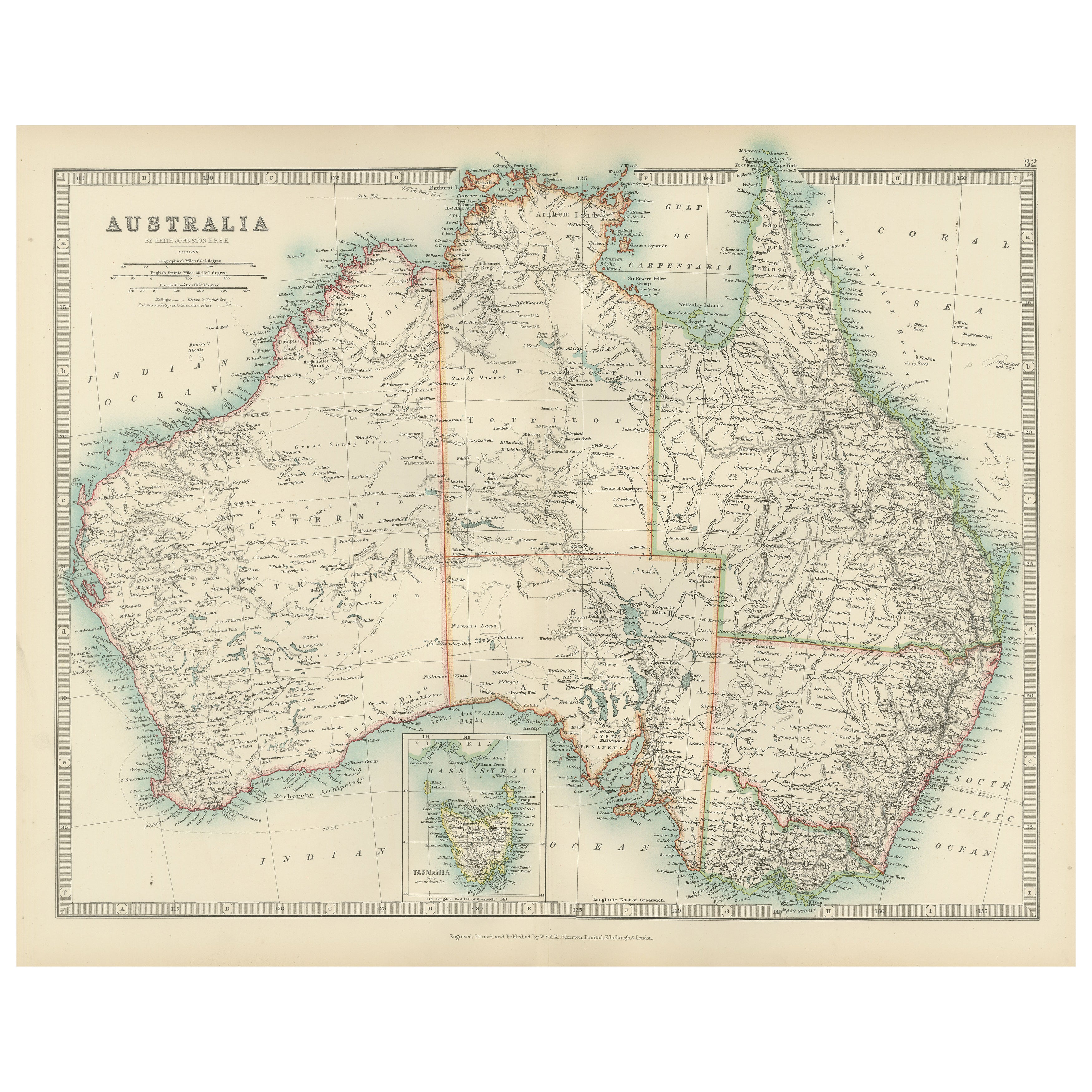
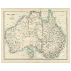
Antique Map of Australia, 1903, with Colonial Divisions and Detailed Topography
Title: Antique Map of Australia, 1903, with Colonial Divisions and Detailed Topography
Description: This antique map, titled "Australia," was engraved and published in 1903 by W. & ...
Catégorie
Début du 20ème siècle, Cartes
Matériaux
Papier
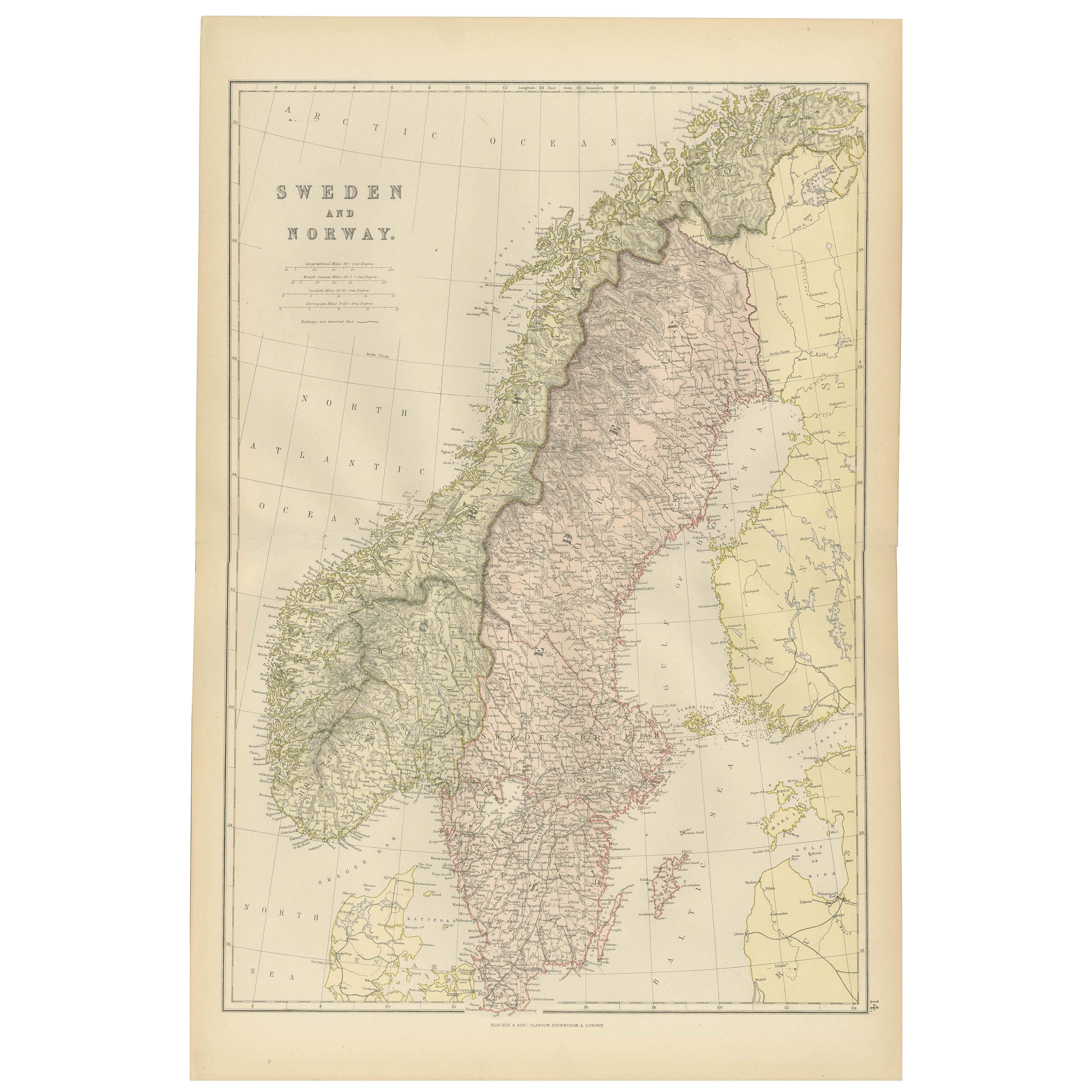
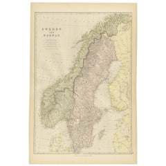
Carte de la Suède et de la Norvège de 1882 mettant en évidence les caractéristiques géographiques et politiques
Cette carte de 1882 de la Suède et de la Norvège, publiée par Blackie and Son dans le cadre du "Comprehensive Atlas and Geography of the World", fournit une description détaillée de ...
Catégorie
Antiquités, années 1880, Cartes
Matériaux
Papier
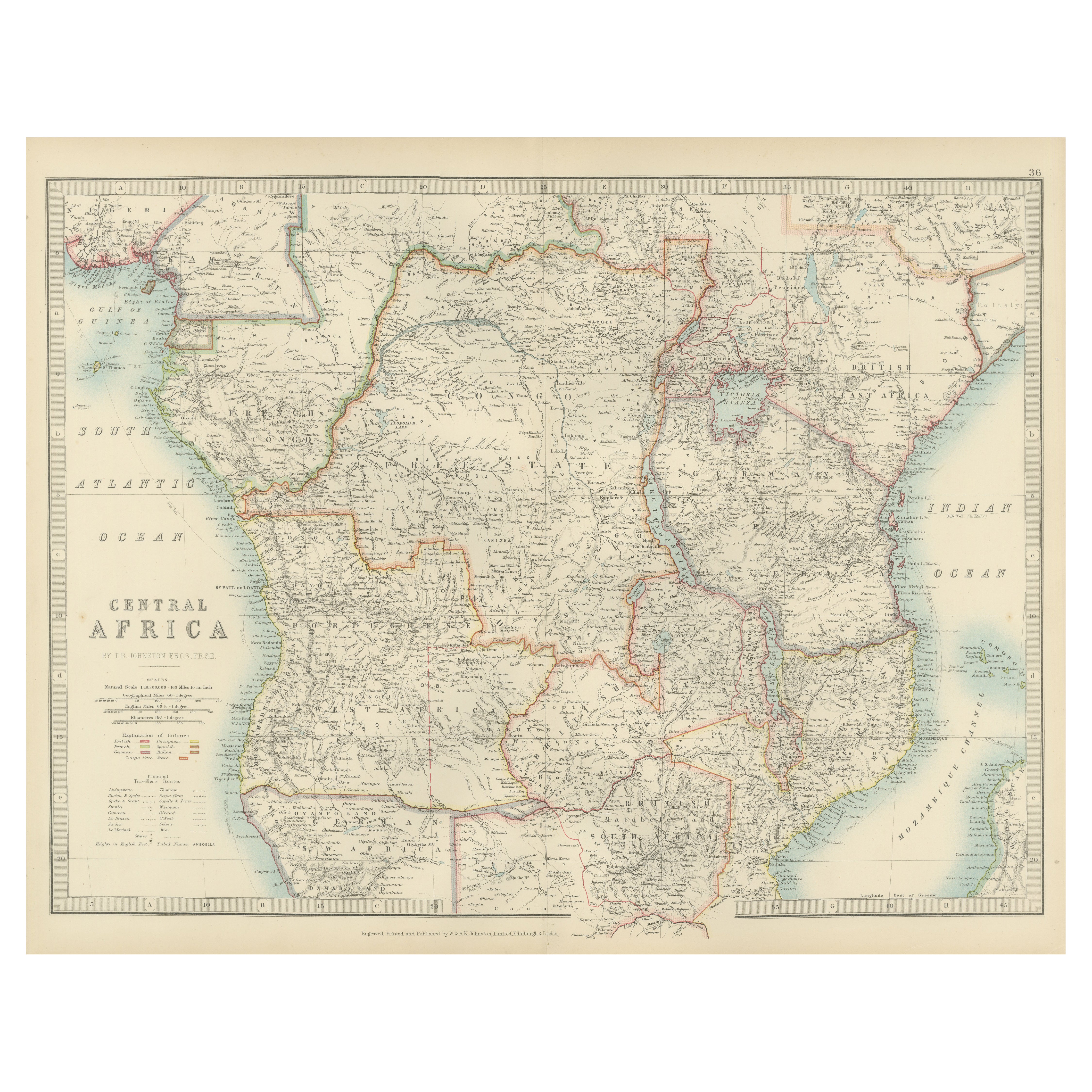
Antique Map of Central Africa, 1903, With Colonial Territories Explorers Routes
Antique Map of Central Africa, 1903, Featuring Colonial Territories and Explorers’ Routes
This antique map, titled "Central Africa," was engraved and published in 1903 by W. & A.K. ...
Catégorie
Début du 20ème siècle, Cartes
Matériaux
Papier

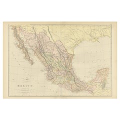
Carte ancienne du Mexique de 1882 mettant en évidence les frontières géographiques et politiques
Cette carte du Mexique de 1882, publiée par Blackie and Son dans le cadre du "Comprehensive Atlas and Geography of the World", offre une représentation très détaillée de la géographi...
Catégorie
Antiquités, années 1880, Cartes
Matériaux
Papier
290 $US
Livraison gratuite
Antique Map of Northern Scotland, 1903, with Intricate Coastal Features
Title: Antique Map of Northern Scotland and Islands, 1903, with Intricate Coastal Features
Description:
This striking antique map, titled "Scotland (Northern Sheet I)," was engraved...
Catégorie
Début du 20ème siècle, Cartes
Matériaux
Papier

Suggestions
Carte géographique ancienne de la Principalité de Monaco
Par Bruno Santini
ST/609 - Intéressante carte ancienne en couleur de la Principauté de Monaco : "Carte qui contient le Principauté de Piémont, le Monferrat et la comté de Nice avec la Rivière de Ponen...
Catégorie
Antiquités, Fin du XVIIIe siècle, italien, Autre, Cartes
Matériaux
Papier

Carte ancienne de l'État américain du Minnesota, 1903
Carte ancienne du Minnesota
Publié par A.I.C Black. 1903
Couleur originale
Bon état
Sans cadre.
Expédition gratuite
Catégorie
Antiquités, Début des années 1900, Anglais, Cartes
Matériaux
Papier

Carte ancienne de l'État américain de l'Alabama, 1903
Antique map of Alabama
Published By A & C Black. 1903
Original colour
Good condition
Unframed.
Free shipping
Catégorie
Antiquités, Début des années 1900, Anglais, Cartes
Matériaux
Papier

Carte ancienne de l'État américain de l'Alaska, 1903
Carte ancienne de l'Alaska
Publié par A.I.C Black. 1903
Couleur originale
Bon état
Sans cadre.
Expédition gratuite
Catégorie
Antiquités, Début des années 1900, Anglais, Cartes
Matériaux
Papier

Carte ancienne de l'État américain du Nebraska, 1903
Carte ancienne du Nebraska
Publié par A.I.C Black. 1903
Couleur originale
Bon état
Sans cadre.
Expédition gratuite
Catégorie
Antiquités, Début des années 1900, Anglais, Cartes
Matériaux
Papier

Carte ancienne d'origine de l'État américain de Washington, 1903
Carte ancienne de Washington
Publié par A.I.C Black. 1903
Couleur originale
Bon état
Sans cadre.
Expédition gratuite
Catégorie
Antiquités, Début des années 1900, Anglais, Cartes
Matériaux
Papier
