Articles similaires à Antique Map of France, 1903, with Inset of Paris and Corsica


Vous voulez plus d'images ou de vidéos ?
Demander au vendeur plus d'images ou de vidéos
1 sur 10
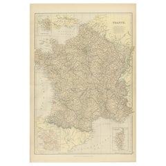
Antique Map of France, 1903, with Inset of Paris and Corsica
À propos de cet article
Title: Antique Map of France, 1903, with Inset of Paris and Corsica
Description:
This antique map, titled "France," was engraved and published in 1903 by the renowned W. & A.K. Johnston firm in Edinburgh and London. It offers a comprehensive and meticulously detailed view of France at the turn of the 20th century, capturing both its diverse geography and its political organization.
The map features an intricate network of departments, with boundaries delicately shaded in pastel greens, pinks, yellows, and blues, making each region stand out with subtle elegance. Cities, towns, rivers, and mountain ranges are finely rendered, showcasing the exceptional craftsmanship and precision that Johnston maps are known for.
A standout feature of this map is its inset detailing the "Environs of Paris," providing an in-depth view of the French capital and its surrounding area. Another inset focuses on the island of Corsica, ensuring no part of the French Republic is left undocumented. The clear, crisp typography and fine linework highlight the map’s quality, while the soft color palette adds a refined aesthetic that complements both modern and traditional interiors.
For collectors and enthusiasts, this map offers more than geographic data—it’s a snapshot of France at a time when the country was a leading European power with a rich cultural and political heritage. It also reflects a period of modernization, with railways connecting even the remotest parts of the nation.
Condition report:
The map is in very good antique condition, with minimal foxing and light edge toning typical for its age. The colors remain vibrant and the paper is stable and well-preserved.
Framing tips:
A dark wooden frame, such as walnut or mahogany, will add warmth and sophistication to this map. Use a cream or off-white matting to highlight the soft pastel colors and intricate detail, making this a refined and elegant focal point in any room or office.
- Dimensions:Hauteur : 36,8 cm (14,49 po)Largeur : 48 cm (18,9 po)Profondeur : 0,2 mm (0,01 po)
- Matériaux et techniques:
- Période:
- Date de fabrication:1903
- État:The map is in very good antique condition, with minor age-related foxing and slight edge toning typical for its vintage. The colors remain vibrant and the paper is stable and well-preserved. Folding line as issued.
- Adresse du vendeur:Langweer, NL
- Numéro de référence:Vendeur : BG-13577-91stDibs : LU3054345241512
À propos du vendeur
5,0
Vendeur reconnu
Ces vendeurs prestigieux sont des leaders du secteur. Ils représentent le summum en matière de qualité et de design.
Vendeur Or
Vendeurs premium dont la note est supérieure à 4,3 et le délai de réponse de 24 heures maximum
Établi en 2009
Vendeur 1stDibs depuis 2017
2 463 ventes sur 1stDibs
Temps de réponse habituel : 1 heure
- ExpéditionRecherche du devis...Expédition depuis : Langweer, Pays-Bas
- Politique des retours
Certaines parties de cette page ont été traduites automatiquement. 1stDibs ne garantit pas l'exactitude des traductions. L'anglais est la langue par défaut de ce site web.
Garantie d'authenticité
Bien qu'il soit peu probable que la situation se présente, dans le cas où vous rencontreriez un problème d'authenticité d'un article, contactez-nous dans un délai d'un an pour obtenir un remboursement intégral. DétailsGarantie de remboursement
Si votre article n'est pas conforme à la description, est endommagé pendant le transport ou ne vous est pas livré, contactez-nous sous 7 jours pour obtenir un remboursement intégral. DétailsAnnulation sous 24 heures
Vous disposez d'un délai de 24 heures pour annuler votre achat sans motif.Des vendeurs professionnels agréés
Nos vendeurs de renommée mondiale doivent respecter des normes strictes en matière de service et de qualité, afin de préserver l'intégrité de nos fiches produit.Garantie d'alignement des prix
Si vous constatez qu'un autre vendeur a mis en vente le même article à un prix inférieur sur un autre site, nous nous alignerons sur ce prix.Livraison en toute confiance à l'international
Notre réseau de transporteurs de premier ordre propose des options d'expédition spécialisées dans le monde entier, y compris des livraisons personnalisées.Plus d'articles de ce vendeur
Tout afficherCarte ancienne de France avec carte insérée de l'île de Corsica, 1820
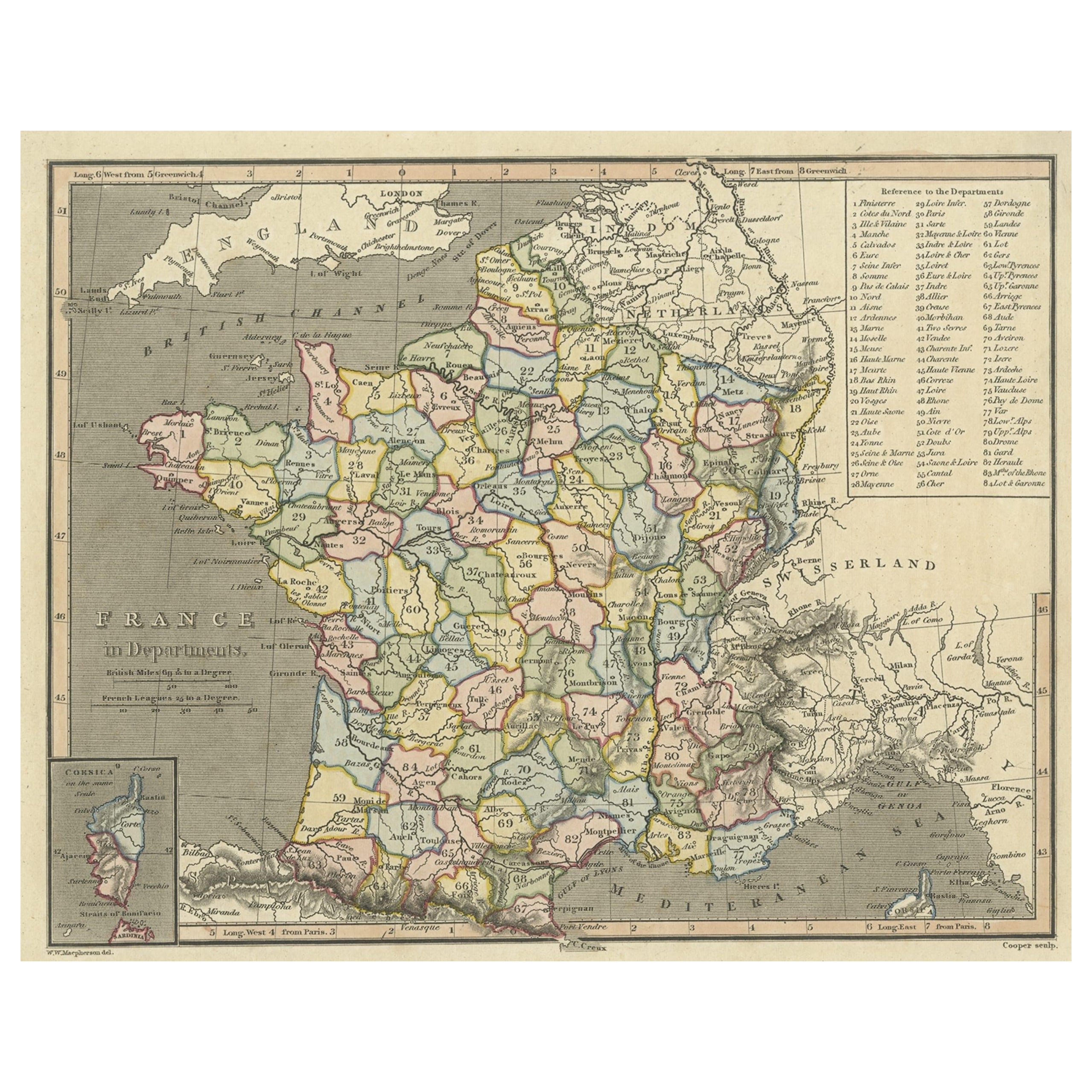
Carte ancienne intitulée "France in Departments". Ancienne carte de France, avec une petite carte insérée de l'île de Corse. Comprend un tableau de référence des départements.
Ar...
Catégorie
Antiquités, XIXe siècle, Cartes
Matériaux
Papier
242 $US Prix de vente
20 % de remise
Carte ancienne de France avec une carte insérée de l'île de Corsica, vers 1820
Carte ancienne intitulée "Frankrijk naar de nieuwste bepalingen meerendeels gevolgd naar Lapie". Belle carte de France avec un encart sur l'île de Corse. Comprend un tableau de référ...
Catégorie
Antiquités, XIXe siècle, Cartes
Matériaux
Papier

167 $US Prix de vente
20 % de remise
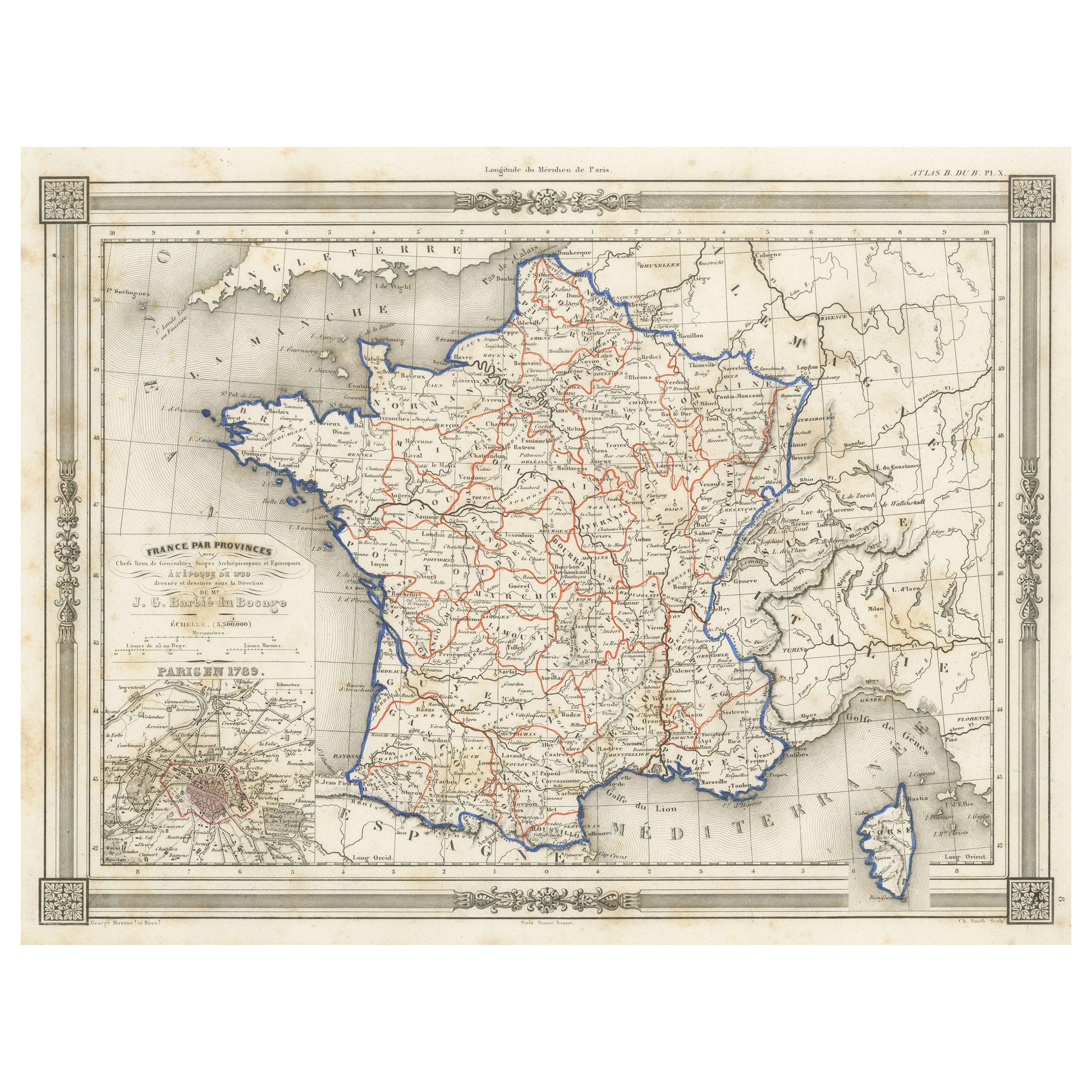
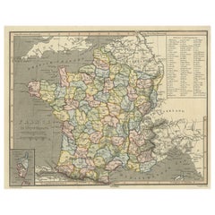
Carte ancienne de la France en provinces, avec incrustation de Paris
Carte ancienne intitulée "France par Provinces". Carte originale ancienne de la France en Provinces. Elle s'étend de la Flandre au nord au Roussillon au sud et de la Bretagne à l'oue...
Catégorie
Antiquités, Milieu du XIXe siècle, Cartes
Matériaux
Papier

102 $US Prix de vente
20 % de remise
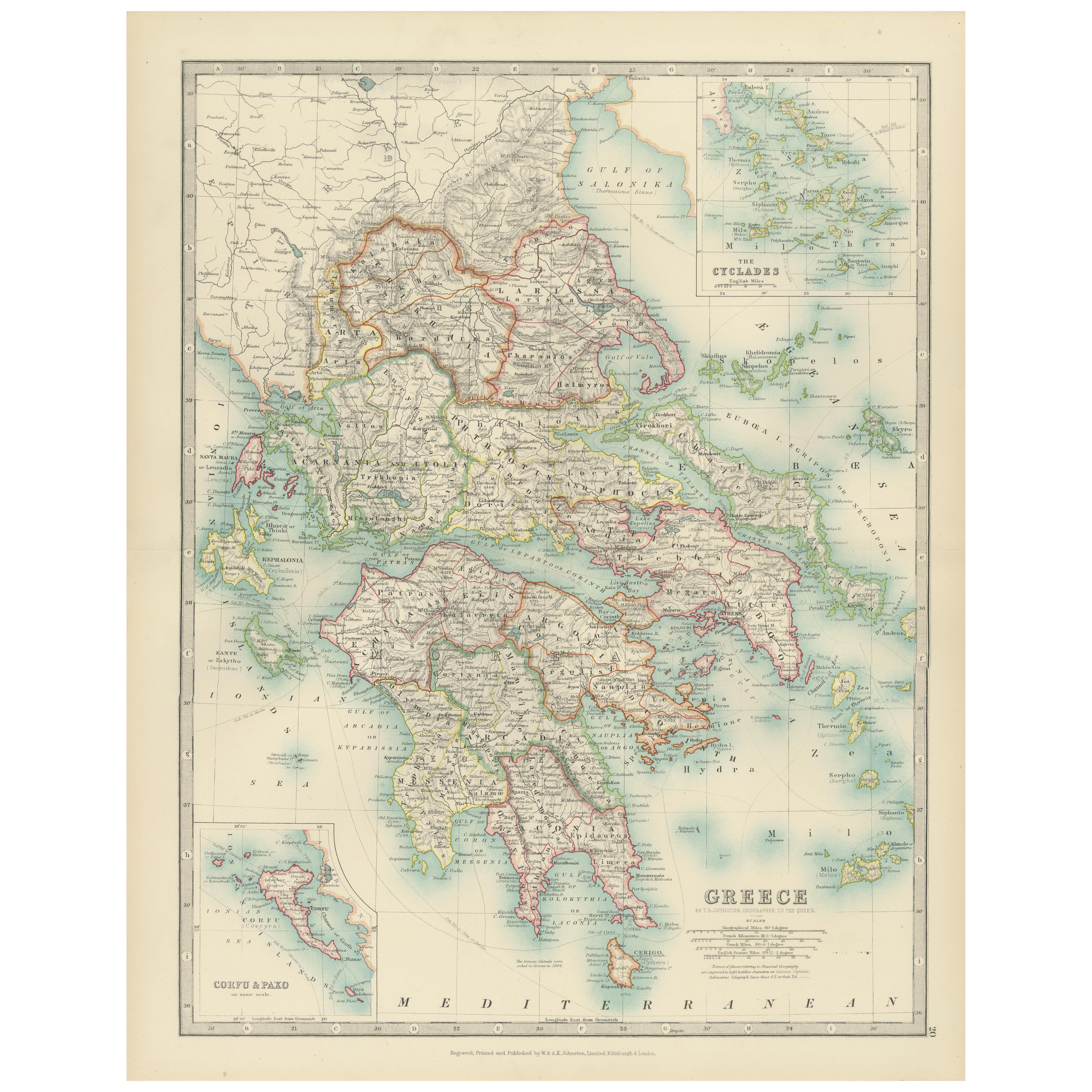
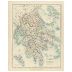
Antique Map of Greece and the Cyclades, 1903, with Many Details and Inset Maps
Title: Antique Map of Greece and the Cyclades, 1903, with Intricate Detail and Inset Maps
Description: This antique map, titled "Greece with Its Islands, Including the Cyclades," wa...
Catégorie
Début du 20ème siècle, Cartes
Matériaux
Papier
Carte de France mettant en valeur les frontières politiques, les villes et les inserts de Corsica, 1882
Cette carte de France de 1882, publiée par Blackie and Son dans le cadre du "Comprehensive Atlas and Geography of the World", offre une description détaillée du pays à la fin du XIXe...
Catégorie
Antiquités, années 1880, Cartes
Matériaux
Papier
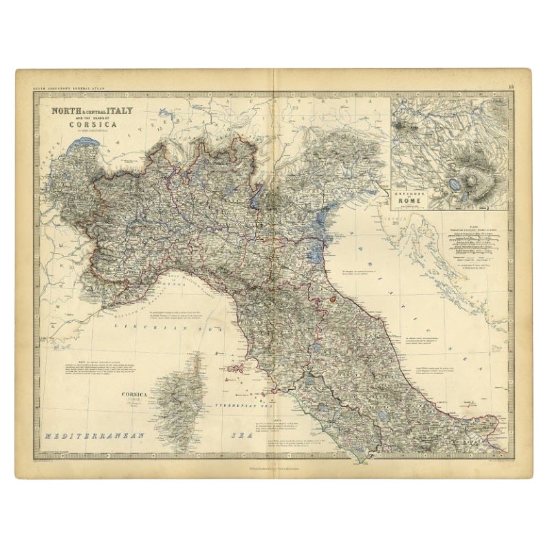
Carte ancienne d'Italie et de Corsica, vers 1860
Carte ancienne intitulée "L'Italie du Nord et du Centre et l'île de Corse".
Carte ancienne de l'Italie du Nord et du Centre, et de l'île de Corse. Avec une carte en médaillon de ...
Catégorie
Antiquités, XIXe siècle, Cartes
Matériaux
Papier
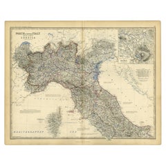
102 $US Prix de vente
20 % de remise
Suggestions
Carte ancienne de l'État américain du Minnesota, 1903
Carte ancienne du Minnesota
Publié par A.I.C Black. 1903
Couleur originale
Bon état
Sans cadre.
Expédition gratuite
Catégorie
Antiquités, Début des années 1900, Anglais, Cartes
Matériaux
Papier

Carte ancienne de l'État américain de l'Alabama, 1903
Antique map of Alabama
Published By A & C Black. 1903
Original colour
Good condition
Unframed.
Free shipping
Catégorie
Antiquités, Début des années 1900, Anglais, Cartes
Matériaux
Papier

Carte ancienne de l'État américain de l'Alaska, 1903
Carte ancienne de l'Alaska
Publié par A.I.C Black. 1903
Couleur originale
Bon état
Sans cadre.
Expédition gratuite
Catégorie
Antiquités, Début des années 1900, Anglais, Cartes
Matériaux
Papier

Carte ancienne de l'État américain du Nebraska, 1903
Carte ancienne du Nebraska
Publié par A.I.C Black. 1903
Couleur originale
Bon état
Sans cadre.
Expédition gratuite
Catégorie
Antiquités, Début des années 1900, Anglais, Cartes
Matériaux
Papier

Carte ancienne d'origine de l'État américain de Washington, 1903
Carte ancienne de Washington
Publié par A.I.C Black. 1903
Couleur originale
Bon état
Sans cadre.
Expédition gratuite
Catégorie
Antiquités, Début des années 1900, Anglais, Cartes
Matériaux
Papier

Carte ancienne de l'État américain du Tennessee, 1903
Antique map of Tennessee
Published By A & C Black. 1903
Original colour
Good condition
Unframed.
Free shipping
Catégorie
Antiquités, Début des années 1900, Anglais, Cartes
Matériaux
Papier
