Articles similaires à Canada’s West – 1903 Engraved Map by Johnston – Unique and Historic


Vous voulez plus d'images ou de vidéos ?
Demander au vendeur plus d'images ou de vidéos
1 sur 10
Canada’s West – 1903 Engraved Map by Johnston – Unique and Historic
À propos de cet article
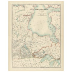
This beautiful and detailed map, titled "Dominion of Canada (Western Sheet)," was created by Keith Johnston and published in 1903.
It presents a fascinating depiction of Canada's western territories, covering regions from British Columbia, Alberta, and parts of Saskatchewan and the Northwest Territories. Johnston, a distinguished Scottish geographer and cartographer, created maps that were not only precise but also highly artistic, reflecting the cartographic standards of the early 20th century.
The map showcases the intricate mountain ranges of British Columbia, the vast plains of Alberta, and the rich river systems that flow through these regions, including the Fraser, Columbia, and Peace Rivers. The rugged coastline of the Pacific Ocean, along with numerous inlets and islands, is carefully delineated, giving insight into the coastal geography of this vast area. The depiction of mountain ranges, particularly the Rocky Mountains, with their shaded relief and meticulous detail, adds depth and a striking visual dimension to the map.
Johnston’s maps were known for their accuracy and elegant typography, evident here in the clean lettering and delicate border treatments. The political boundaries of the provinces and territories are outlined in color, aiding in the visual separation of these areas and providing historical context to the development of Canada's western frontier. Notably, the map also includes names of smaller settlements, indigenous territories, trading posts, and other historical landmarks, reflecting the mapmaker's dedication to comprehensive geographic documentation.
This map is an exceptional piece for collectors, historians, and anyone with an interest in Canada's western development. It speaks to the era's growing interest in exploration and the expansion of railways and settlements across this breathtaking landscape.
The map’s condition is excellent, with clear, sharp impressions and only minor signs of age-related toning, adding to its antique charm.
For framing, consider using a classic wooden or dark-colored frame with a neutral mat to enhance the subtle colors and fine details of the engraving. This would make a striking focal point in a study, office, or living space, offering both historical insight and timeless visual appeal.
- Dimensions:Hauteur : 47 cm (18,51 po)Largeur : 36,8 cm (14,49 po)Profondeur : 0,2 mm (0,01 po)
- Matériaux et techniques:
- Période:
- Date de fabrication:1903
- État:The map’s condition is excellent, with clear, sharp impressions and only minor signs of age-related toning, adding to its antique charm.
- Adresse du vendeur:Langweer, NL
- Numéro de référence:Vendeur : BG-13577-441stDibs : LU3054345291632
À propos du vendeur
5,0
Vendeur reconnu
Ces vendeurs prestigieux sont des leaders du secteur. Ils représentent le summum en matière de qualité et de design.
Vendeur Or
Vendeurs premium dont la note est supérieure à 4,3 et le délai de réponse de 24 heures maximum
Établi en 2009
Vendeur 1stDibs depuis 2017
2 463 ventes sur 1stDibs
Temps de réponse habituel : <1 heure
- ExpéditionRecherche du devis...Expédition depuis : Langweer, Pays-Bas
- Politique des retours
Certaines parties de cette page ont été traduites automatiquement. 1stDibs ne garantit pas l'exactitude des traductions. L'anglais est la langue par défaut de ce site web.
Garantie d'authenticité
Bien qu'il soit peu probable que la situation se présente, dans le cas où vous rencontreriez un problème d'authenticité d'un article, contactez-nous dans un délai d'un an pour obtenir un remboursement intégral. DétailsGarantie de remboursement
Si votre article n'est pas conforme à la description, est endommagé pendant le transport ou ne vous est pas livré, contactez-nous sous 7 jours pour obtenir un remboursement intégral. DétailsAnnulation sous 24 heures
Vous disposez d'un délai de 24 heures pour annuler votre achat sans motif.Des vendeurs professionnels agréés
Nos vendeurs de renommée mondiale doivent respecter des normes strictes en matière de service et de qualité, afin de préserver l'intégrité de nos fiches produit.Garantie d'alignement des prix
Si vous constatez qu'un autre vendeur a mis en vente le même article à un prix inférieur sur un autre site, nous nous alignerons sur ce prix.Livraison en toute confiance à l'international
Notre réseau de transporteurs de premier ordre propose des options d'expédition spécialisées dans le monde entier, y compris des livraisons personnalisées.Plus d'articles de ce vendeur
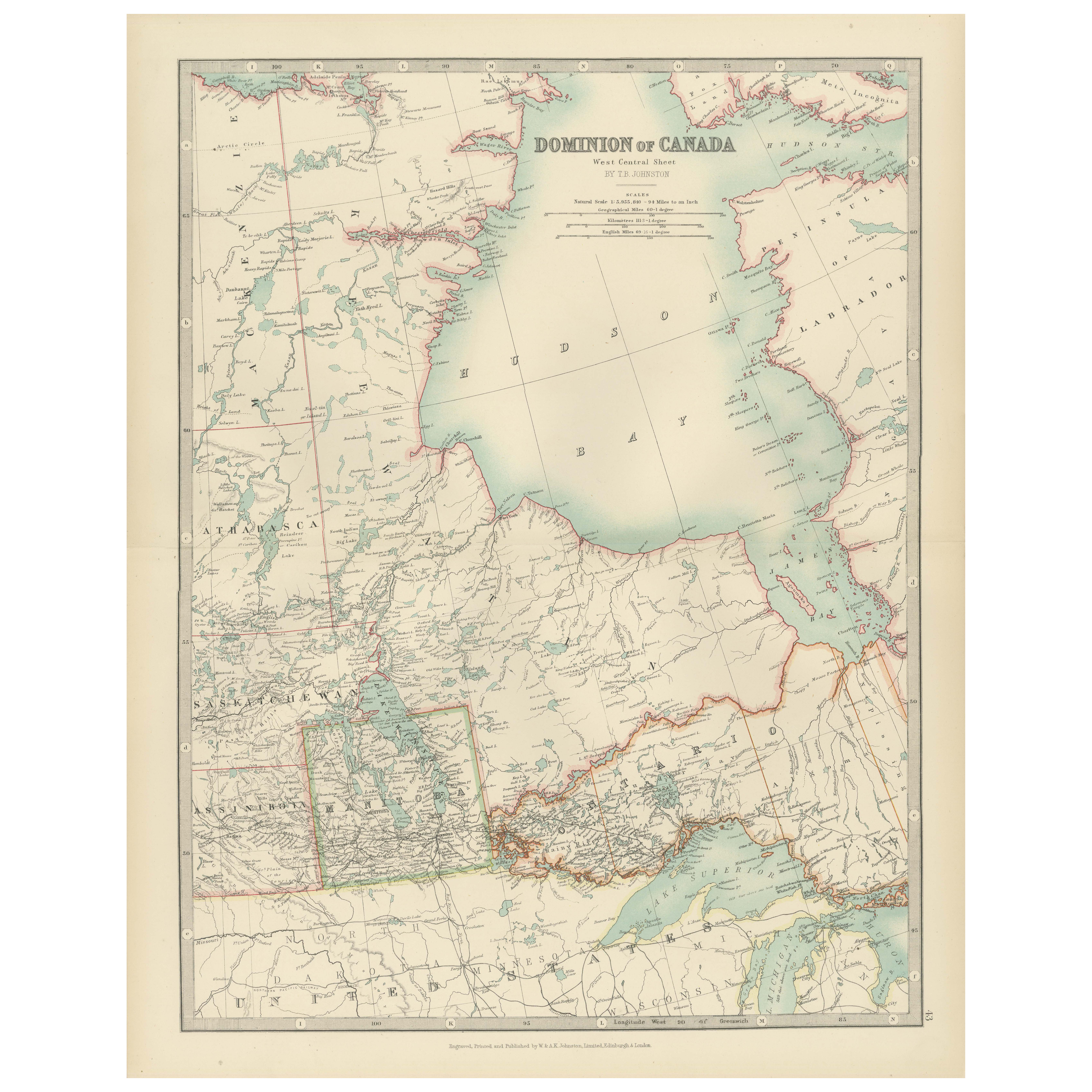
Tout afficherCanada Map 1903 - Dominion of Canada, West Central Sheet
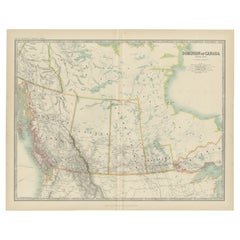
Title: Canada Map 1903 - Dominion of Canada, West Central Sheet
Description:
This fascinating 1903 map of the Dominion of Canada’s West Central regions by T.R. Johnston offers a viv...
Catégorie
Début du 20ème siècle, Cartes
Matériaux
Papier
Carte ancienne du Canada par Johnston '1909'
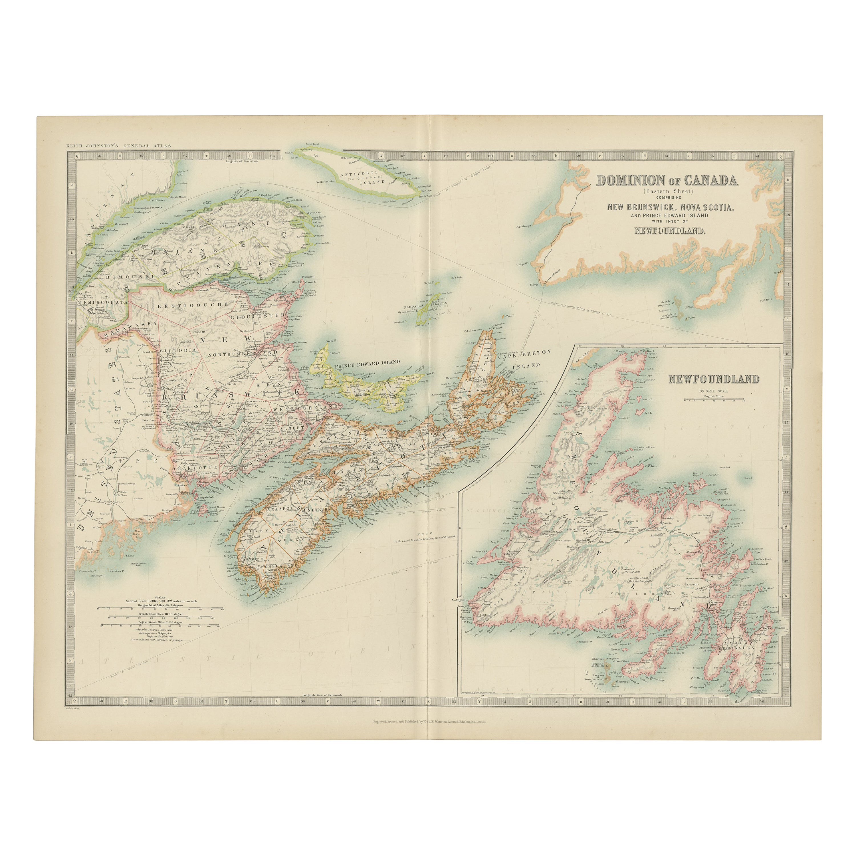
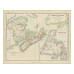
Carte ancienne intitulée "Dominion of Canada". Carte ancienne originale du Canada. Avec un encart de la carte de Terre-Neuve. Cette carte provient du "Royal Atlas of Modern Geography...
Catégorie
Début du 20ème siècle, Cartes
Matériaux
Papier
232 $US Prix de vente
20 % de remise
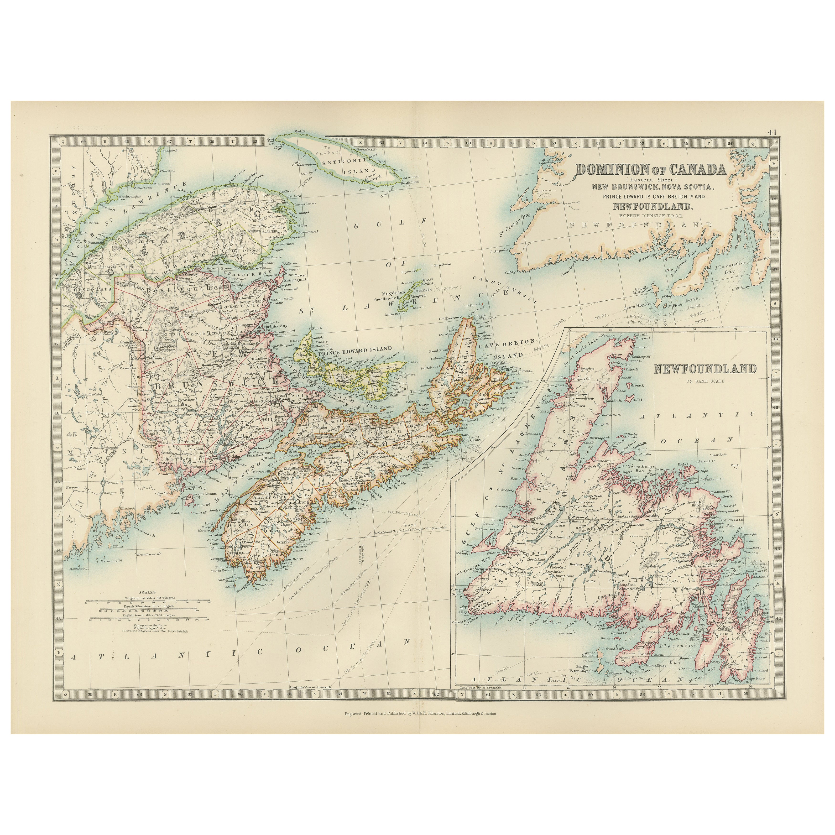
Carte ancienne du Canada par Johnston '1909'
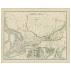
Carte ancienne intitulée "Dominion of Canada". Carte ancienne originale du Canada. Cette carte provient du "Royal Atlas of Modern Geography". Publié par W. & A.K. Johnston, 1909.
Catégorie
Début du 20ème siècle, Cartes
Matériaux
Papier
232 $US Prix de vente
20 % de remise
Carte ancienne du Canada par Johnston '1909'
Carte ancienne intitulée "Dominion of Canada". Carte ancienne originale du Canada. Avec des cartes en médaillon de Niagara, Montréal, Québec. Cette carte provient du "Royal Atlas of ...
Catégorie
Début du 20ème siècle, Cartes
Matériaux
Papier
232 $US Prix de vente
20 % de remise
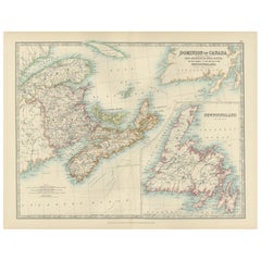
Canada Dominion Map 1903 - A Detailed View of Eastern Canada and Newfoundland
North America, 1903 - A Colorful Historical Map with Detailed Borders
This attractive map of North America was engraved, printed, and published by W. & A.K. Johnston in 1903. A wond...
Catégorie
Début du 20ème siècle, Cartes
Matériaux
Papier
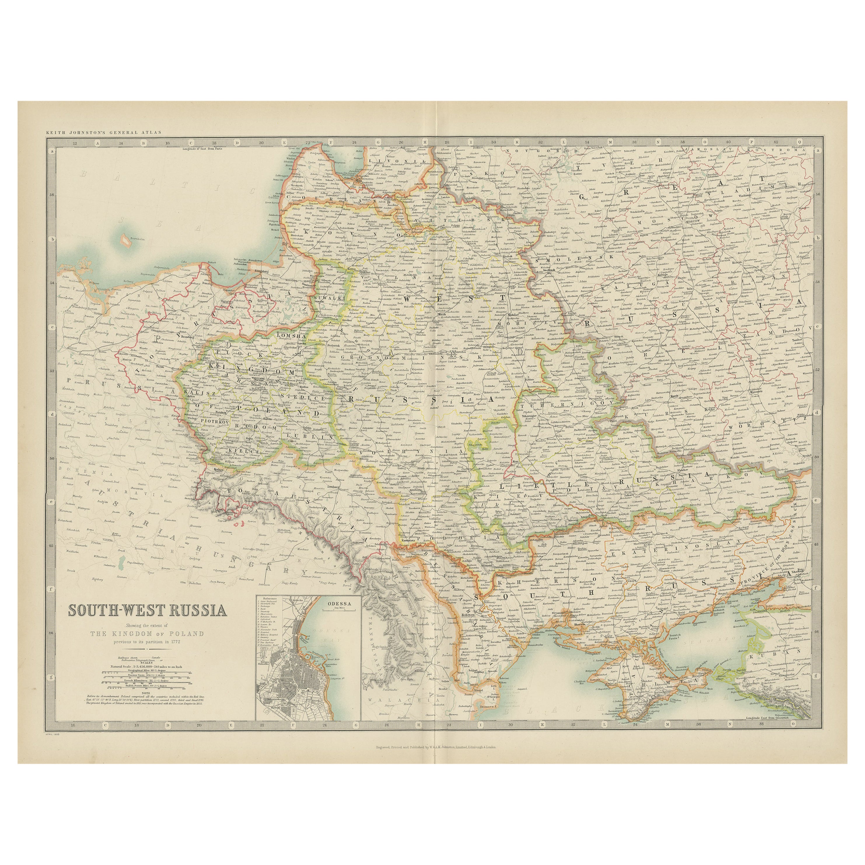
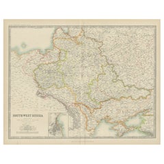
Carte ancienne de la Russie du Sud-Ouest par Johnston (1909)
Carte ancienne intitulée "South-West Russia". Carte originale ancienne de la Russie du South Antiques. Avec carte d'Odessa en médaillon. Cette carte provient du "Royal Atlas of Moder...
Catégorie
Début du 20ème siècle, Cartes
Matériaux
Papier
232 $US Prix de vente
20 % de remise
Suggestions
Carte de l'Amérique du Nord de 1846, gravée par I. Dower
Voici une carte originale de 1846 de l'"Amérique du Nord". La carte a été dessinée et gravée par I. Dower et publiée à Londres par Orr & Company. La carte représente l'Amérique du No...
Catégorie
Antiquités, années 1840, Anglais, Victorien, Cartes
Matériaux
Papier

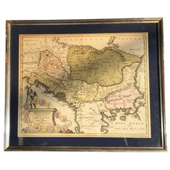
Quatre cartes du XVIIIe siècle gravées et coloriées à la main par Weigel
Par Christoph Weigel
Petite collection de quatre cartes gravées de l'Italie, des Balkans et de l'Asie centrale.
Deux sont d'Italie, l'un de Corse et d'Italie du Nord et l'autre de la botte italienne mé...
Catégorie
Antiquités, XVIIIe siècle, Allemand, Cartes
Matériaux
Papier
Carte originale et ancienne de la Suède, gravée par Barlow, 1806
Grande carte de la Suède
Gravure sur cuivre de Barlow
Publié par Brightly & Kinnersly, Bungay, Suffolk. 1806
Non encadré.
Catégorie
Antiquités, Début des années 1800, Anglais, Cartes
Matériaux
Papier

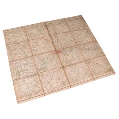
Carte de Londres pliante ancienne, anglaise, cartographie, historique, géorgienne, datée de 1783
Il s'agit d'une ancienne carte pliante de Londres. Une étude cartographique anglaise sur papier et lin de la métropole londonienne et de ses environs, publiée au milieu de la période...
Catégorie
Antiquités, Fin du XVIIIe siècle, Britannique, Georgien, Cartes
Matériaux
Lin, Papier
Carte ancienne de la Suisse, gravée par Barlow, datée de 1807
Grande carte de la Suisse
Gravure sur cuivre de Barlow
Publié par Brightly & Kinnersly, Bungay, Suffolk.
Daté de 1807
Sans cadre.
Catégorie
Antiquités, Début des années 1800, Anglais, Cartes
Matériaux
Papier

Carte ancienne de l'État américain du Minnesota, 1903
Carte ancienne du Minnesota
Publié par A.I.C Black. 1903
Couleur originale
Bon état
Sans cadre.
Expédition gratuite
Catégorie
Antiquités, Début des années 1900, Anglais, Cartes
Matériaux
Papier
