Articles similaires à Carte ancienne de Roermond et du Duché de Gueldre par Sanson - coloriée à la main, c.1667


Vous voulez plus d'images ou de vidéos ?
Demander au vendeur plus d'images ou de vidéos
1 sur 10
Carte ancienne de Roermond et du Duché de Gueldre par Sanson - coloriée à la main, c.1667
580 €TVA incluse
À propos de cet article
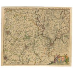
Antique map of Roermond and the Duchy of Guelders with rich detail, c.1667
This beautifully hand-colored 17th-century map presents the region of Roermond and the broader Duchy of Guelders (Gelderland), a historically significant area in what is now the southeastern Netherlands. The map, engraved with fine detail and artistic embellishment, provides a striking glimpse into the political and geographic landscape of the time. It includes not only Roermond but a wide swath of surrounding towns, rivers, and territorial boundaries.
The map is titled Menapil Evesché de Ruremonde Quartier de Gueldres du Duché de Gueldres and showcases the ecclesiastical and administrative divisions with great clarity. The winding river Maas (Meuse), which forms a natural boundary in several places, is prominently featured in dark blue, drawing the viewer's eye through the composition. Cities and towns are marked with red symbols, and shaded relief indicates mountain ranges and forests. This stylistic approach helps to visualize the region's terrain and its natural barriers, which played a key role in historical conflicts and trade routes.
The artistic cartouche in the lower left corner is elegantly decorated in red and green flourishes, framing the map’s title in classic 17th-century French. The attention to topographical accuracy, political subdivisions, and decorative elements make this print not only historically significant but also a work of art in its own right.
This map would appeal to collectors of Low Countries cartography, historians interested in the Duchy of Guelders, and interior decorators seeking a sophisticated and authentic antique centerpiece. Its geographic focus on a part of Europe where borders were frequently contested gives it added value for those intrigued by historical shifts in power, religion, and trade.
Condition:
Good condition overall. The hand-coloring remains vibrant, with only minor age-toning. Plate mark is strong. This map has been framed before, hence the difference in the border color outside the image. No tears or major foxing visible.
Framing tips:
To enhance its decorative appeal, consider a classic gold or dark wood frame with a wide, off-white acid-free mat to offset the strong colors. UV-protective glass is recommended to preserve the hand-coloring. The map’s vertical composition and balanced detailing make it ideal for display in studies, libraries, or entrance halls. A float-mount frame could also be an elegant option, showcasing the plate mark and original paper edges.
- Dimensions:Hauteur : 43,6 cm (17,17 po)Largeur : 46,7 cm (18,39 po)Profondeur : 0,2 mm (0,01 po)
- Matériaux et techniques:Papier,Gravé
- Lieu d'origine:
- Période:Fin du XVIIe siècle
- Date de fabrication:1667
- État:Good condition overall. The hand-coloring remains vibrant, with only minor age-toning. Plate mark is strong. This map has been framed before, hence the difference in the border color outside the image. No tears or major foxing visible.
- Adresse du vendeur:Langweer, NL
- Numéro de référence:Vendeur : BG-14068-11stDibs : LU3054345401892
À propos du vendeur
5,0
Vendeur reconnu
Ces vendeurs prestigieux sont des leaders du secteur. Ils représentent le summum en matière de qualité et de design.
Vendeur Platine
Vendeurs premium dont la note est supérieure à 4,7 et le délai de réponse de 24 heures maximum
Établi en 2009
Vendeur 1stDibs depuis 2017
2 641 ventes sur 1stDibs
Temps de réponse habituel : <1 heure
- ExpéditionRecherche du devis...Expédition depuis : Langweer, Pays-Bas
- Politique des retours
Certaines parties de cette page ont été traduites automatiquement. 1stDibs ne garantit pas l'exactitude des traductions. L'anglais est la langue par défaut de ce site web.
Garantie d'authenticité
Bien qu'il soit peu probable que la situation se présente, dans le cas où vous rencontreriez un problème d'authenticité d'un article, contactez-nous dans un délai d'un an pour obtenir un remboursement intégral. DétailsGarantie de remboursement
Si votre article n'est pas conforme à la description, est endommagé pendant le transport ou ne vous est pas livré, contactez-nous sous 7 jours pour obtenir un remboursement intégral. DétailsAnnulation sous 24 heures
Vous disposez d'un délai de 24 heures pour annuler votre achat sans motif.Des vendeurs professionnels agréés
Nos vendeurs de renommée mondiale doivent respecter des normes strictes en matière de service et de qualité, afin de préserver l'intégrité de nos fiches produit.Garantie d'alignement des prix
Si vous constatez qu'un autre vendeur a mis en vente le même article à un prix inférieur sur un autre site, nous nous alignerons sur ce prix.Livraison en toute confiance à l'international
Notre réseau de transporteurs de premier ordre propose des options d'expédition spécialisées dans le monde entier, y compris des livraisons personnalisées.Plus d'articles de ce vendeur
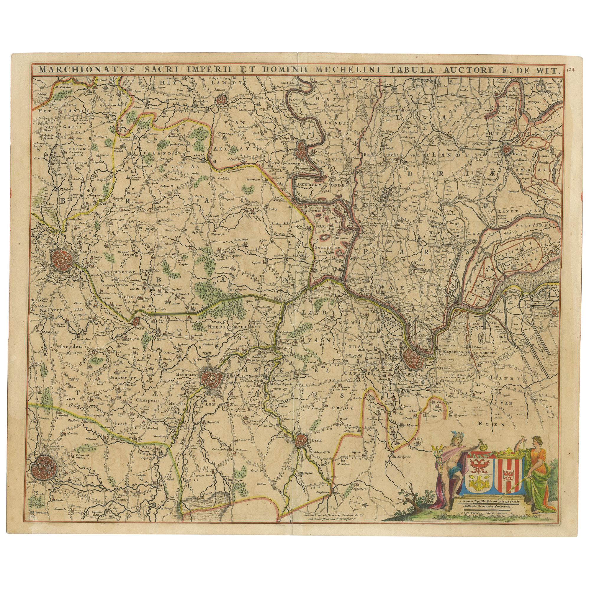
Tout afficherCarte ancienne d'une partie des Flandres en Belgique par F. de Wit, datant d'environ 1680
Carte ancienne intitulée "Marchionatus Sacri Imperii et Dominii Mechelini Tabula". Grande carte au format folio de la région autour de Malines, Louvain, Bruxelles, Termonde et Anvers...
Catégorie
Antiquités, Fin du XVIIe siècle, Cartes
Matériaux
Papier
460 € Prix de vente
20 % de remise
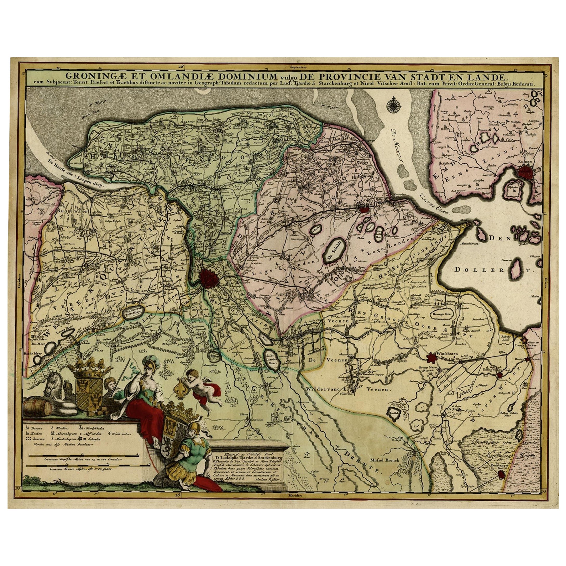
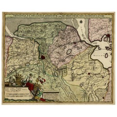
Carte ancienne colorée à la main de la province néerlandaise de Groningen, Incl. Emden, vers 1680
Gravure ancienne, intitulée : "Groningae et Omlandiae Dominium vulgo de Pronvicie van Stadt en Lande ..."
Une carte de la province néerlandaise de Groningue. Une petite partie de l'Allemagne est également représentée (Emden). Publié par Nicolaes Visscher...
Catégorie
Antiquités, 1680, Cartes
Matériaux
Papier
760 € Prix de vente
20 % de remise
Carte ancienne de la région du Hainaut et de Namur par Janssonius:: "vers 1640"
Par Johannes Janssonius
Carte ancienne intitulée "Comitatuum Hannoniae et Namurci Descriptio". Ancienne carte de la région du Hainaut et de Namur, France. Publié par J. Janssonius, vers 1640.
Catégorie
Antiquités, Milieu du XVIIe siècle, Cartes
Matériaux
Papier

400 € Prix de vente
20 % de remise
Carte ancienne de Belgique et d'entourages, 1692
Carte ancienne intitulée "Provincie Meridionali de Paesi Bassi Intese sotto nome di Fiandra overo Li Paesi Bassi Cattolici con li confini di Francia di Allemagna et di Hollanda". Car...
Catégorie
Antiquités, 17ème siècle, Cartes
Matériaux
Papier

340 € Prix de vente
20 % de remise
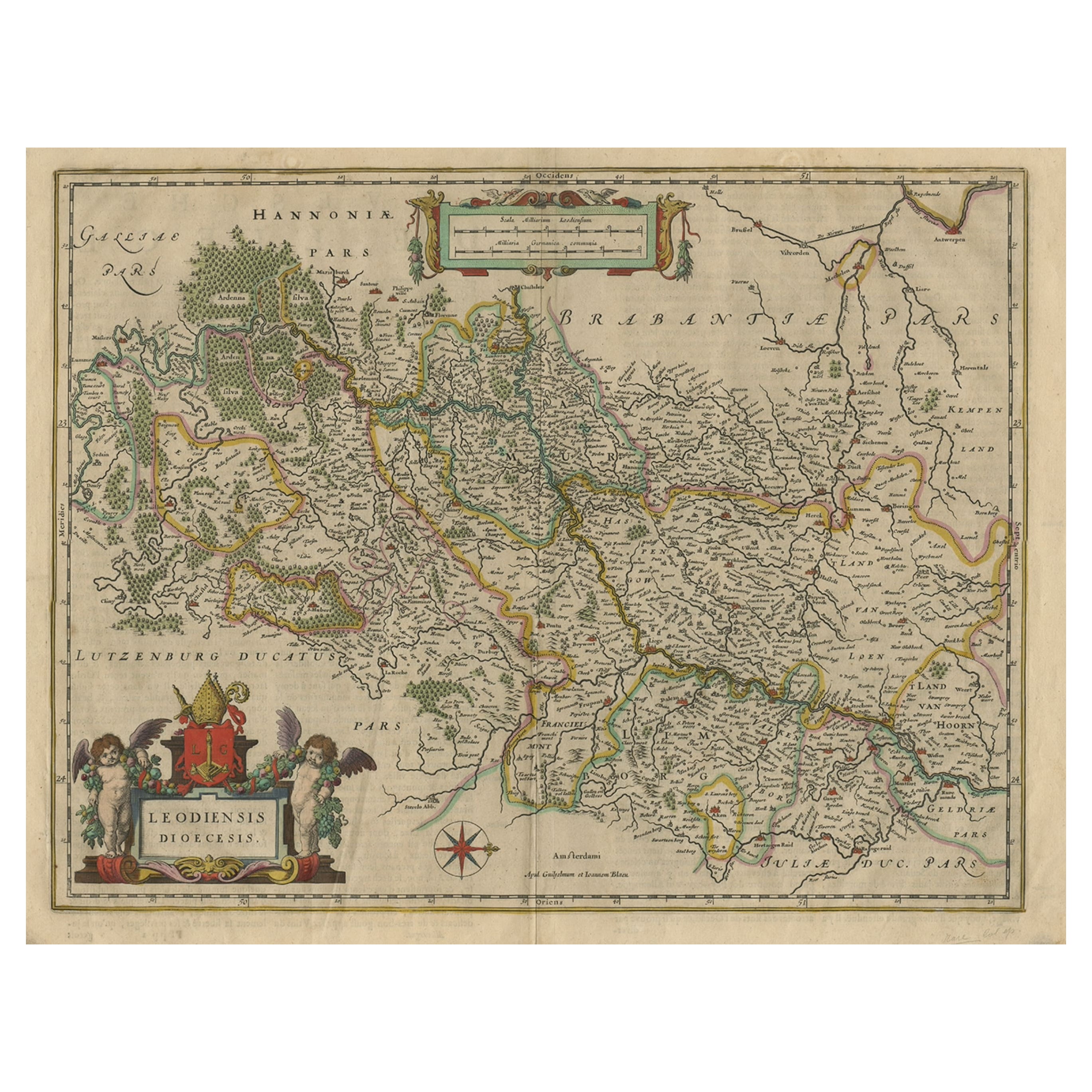
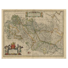
Carte ancienne des provinces néerlandaises et belges du Limbourg, de Namen et d'Ardennes, vers 1635
Gravure ancienne, titrée : "Leodiensis Dioecesis"
Carte détaillée comprenant les provinces néerlandaise et belge du Limbourg et la province belge de Namen et des Ardennes. Gravur...
Catégorie
Antiquités, années 1630, Cartes
Matériaux
Papier
520 € Prix de vente
20 % de remise
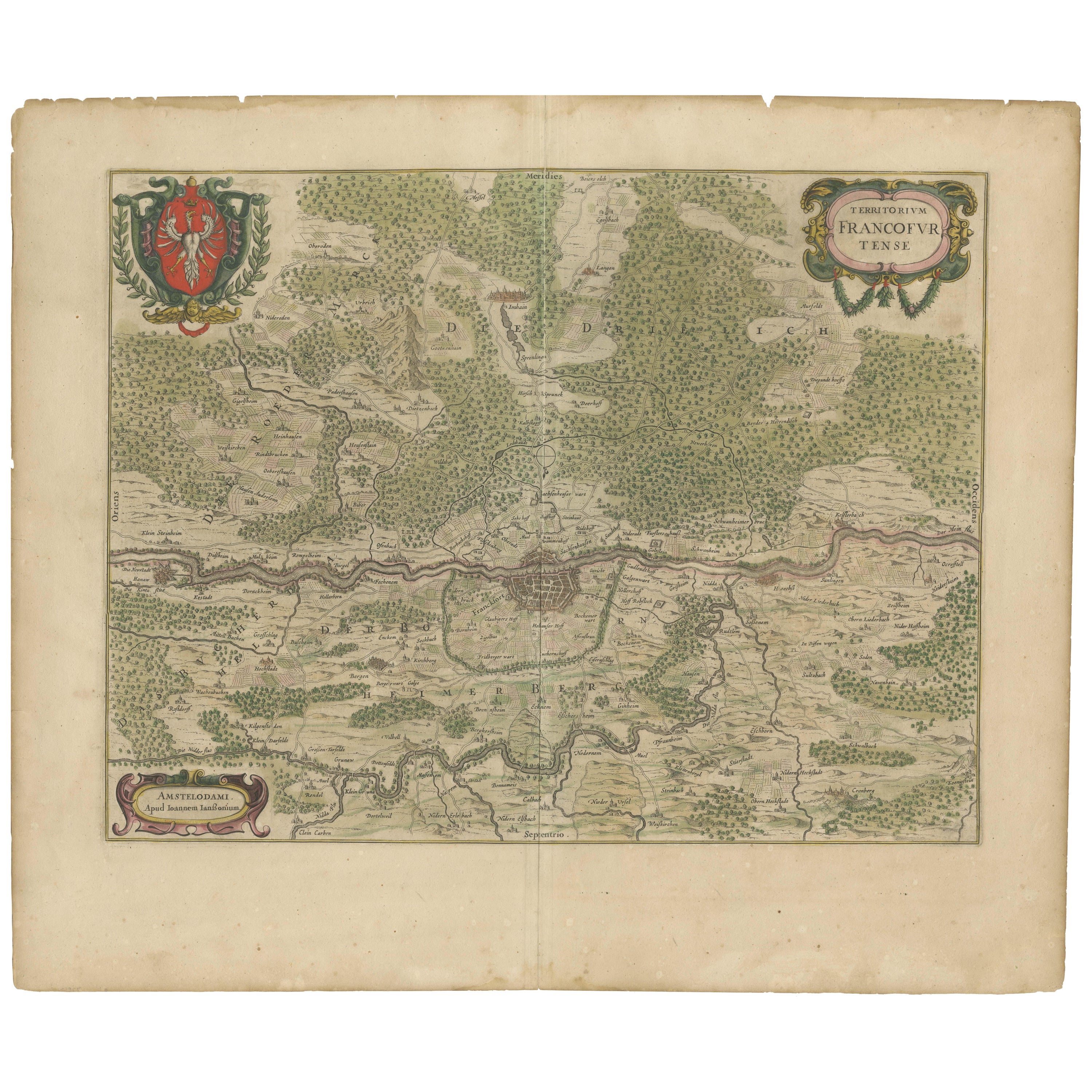
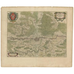
Carte ancienne de la région de Francfort par Johannes Janssonius, colorée à la main, vers 1650
Carte ancienne de la région de Francfort par Johannes Janssonius vers 1650 coloriée à la main
Cette carte ancienne, rare et magnifiquement détaillée, intitulée Territorium Francof...
Catégorie
Antiquités, années 1650, Cartes
Matériaux
Papier
Suggestions
Carte de Willem Blaeu de la France du Nord « Comitatvs Bellovacvm » Ric.a08
1635 Carte de Willem Blaeu du nord de la France, intitulée.
"Comitatvs Bellovacvm Vernacule Beavvais,"
Coloré
Ric.a008
"COMITATVS BELLOVACVM......
Catégorie
Antiquités, 17ème siècle, Inconnu, Cartes
Matériaux
Papier

Carte de Willem Blaeu intitulée « Ilcadorino », colorée à la main Ric0009 1571-1638
Carte de Willem Blaeu intitulée,
"Ilcadorino,".
Coloré à la main.
Description : grande, inhabituelle, et belle carte ancienne gravée sur cuivre d'Ilcadorino, par Willem BLAEU ...
Catégorie
Antiquités, XVIe siècle, Néerlandais, Cartes
Matériaux
Papier

Carte de Joan Bleau de 1640 intitulée "Diocecese de rheims et le pais de rethel", Eic.a011
1640 Carte de Joan Bleau intitulée
"Diocecese de rheims et le pais de rethel,"
Ric.a011
OAN BLAEU
Diocecese de Rheims, et le pais de Rethel.
Gravure coloriée à la main...
Catégorie
Antiquités, 17ème siècle, Néerlandais, Cartes
Matériaux
Papier

Carte de 1640 Willem Blaeu intitulée « Contado di molise et principato vltra » (Contado di molise et principato vltra), Ric.a003
Par Willem Blaeu
1640 Carte de Willem Blaeu intitulée
"Contado di molise et principato vltra,"
Coloré
Ric. a003
Mesures : 38 x 49,6 cm et grandes marges
DBLAEU...
Catégorie
Antiquités, 17ème siècle, Néerlandais, Cartes
Matériaux
Papier

Allemagne de l'Ouest : carte originale du XVIIe siècle colorée à la main par Johannes Janssonius
Par Johannes Janssonius
Carte originale gravée sur cuivre et colorée à la main, intitulée en latin "Archiepiscopatus Maghdeburgensis et Anhaltinus Ducatus cum terris adjacentibus", publiée à Amsterdam en 16...
Catégorie
Milieu du XVIIe siècle, Maîtres anciens, Plus d'Estampes
Matériaux
Gravure

Carte d'Artois de 1620 intitulée « Artesia Comitatvs Artois, » par Bleau, Ric.a012
Carte de l'Artois de 1640 intitulée
"Artesia Comitatvs Artois", "Artesia Comitatvs Artois", "Artesia Comitatvs Artois", "Artesia Comitatvs Artois", etc.
par Bleau
Coloré
A-012....
Catégorie
Antiquités, 17ème siècle, Néerlandais, Cartes
Matériaux
Papier
