Articles similaires à Carte impériale de la Russie septentrionale avec Archangel, Laponie et Permia, C.C.C.


Vous voulez plus d'images ou de vidéos ?
Demander au vendeur plus d'images ou de vidéos
1 sur 10
Carte impériale de la Russie septentrionale avec Archangel, Laponie et Permia, C.C.C.
470 €TVA incluse
À propos de cet article
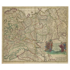
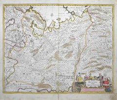
Imperial map of Northern Russia with Archangel, Lapland, and Permia, c.1730
Description:
This intricately engraved and hand-colored map presents the northern reaches of the Russian Empire as it was known in the early 18th century. Created by Matthäus Seutter of Augsburg, one of the leading German mapmakers of the period, the map is titled *Mappae Imperii Moscovitici pars Septentrionalis*, or “Map of the Northern Part of the Muscovite Empire.”
The composition focuses on the regions from St. Petersburg and Ingria in the west to the Ural regions of Perm and Yugoria in the east. The map also includes parts of Lapland, the White Sea (labeled Mare Album or Biar More), and the coastlines of the Barents Sea (Mare Moscoviticum). Important geographic features such as Lacus Onega and Ladoga are finely rendered, as are major rivers like the Dvina and the Northern Dvina.
Seutter divides the territory into color-coded regions such as Regio Czarn, Permia, Jugoria, and Tzernia, reflecting administrative and historical divisions within the empire. Cities including Archangel (Archangelsk), Novgorod, and Vologda are marked, while dense forests and mountain ranges are illustrated using fine hachuring techniques and symbolic trees.
The cartouche in the upper right corner is decorated in classical baroque style with scrollwork, flags, and figures, flanked by a heraldic crest and a depiction of trading ships—emphasizing the region’s commercial and imperial importance. This map is printed in Latin, underscoring its intended audience of learned European elites.
What makes this print especially appealing is its blend of scientific ambition and artistic flourish. It captures a region that was still largely mysterious to Western Europeans in the 18th century, offering insight into how the Russian north was perceived and mapped by German scholars and cartographers.
Condition:
Fair condition. Original hand coloring is well-preserved with minimal age toning. Central fold with water staining; some paper waviness and discoloration present. Study the images carefully.
Framing tips:
For best presentation, consider a dark wood or black frame with a linen or neutral mat to draw attention to the map’s subtle coloring. The ornate cartouche would benefit from generous spacing to let it stand out visually. Use UV-protective glass to safeguard the hand-applied color. Given the map’s vertical orientation and historical interest, it’s ideal for a study, library, or gallery wall focused on exploration and empire.
- Dimensions:Hauteur : 51 cm (20,08 po)Largeur : 59 cm (23,23 po)Profondeur : 0,2 mm (0,01 po)
- Matériaux et techniques:Papier,Gravé
- Lieu d'origine:
- Période:
- Date de fabrication:circa 1730
- État:Fair condition. Original hand coloring is well-preserved with minimal age toning. Central fold with water staining; some paper waviness and discoloration present. Study the images carefully.
- Adresse du vendeur:Langweer, NL
- Numéro de référence:Vendeur : BG-14068-31stDibs : LU3054345402132
À propos du vendeur
5,0
Vendeur reconnu
Ces vendeurs prestigieux sont des leaders du secteur. Ils représentent le summum en matière de qualité et de design.
Vendeur Platine
Vendeurs premium dont la note est supérieure à 4,7 et le délai de réponse de 24 heures maximum
Établi en 2009
Vendeur 1stDibs depuis 2017
2 609 ventes sur 1stDibs
Temps de réponse habituel : <1 heure
- ExpéditionRecherche du devis...Expédition depuis : Langweer, Pays-Bas
- Politique des retours
Certaines parties de cette page ont été traduites automatiquement. 1stDibs ne garantit pas l'exactitude des traductions. L'anglais est la langue par défaut de ce site web.
Garantie d'authenticité
Bien qu'il soit peu probable que la situation se présente, dans le cas où vous rencontreriez un problème d'authenticité d'un article, contactez-nous dans un délai d'un an pour obtenir un remboursement intégral. DétailsGarantie de remboursement
Si votre article n'est pas conforme à la description, est endommagé pendant le transport ou ne vous est pas livré, contactez-nous sous 7 jours pour obtenir un remboursement intégral. DétailsAnnulation sous 24 heures
Vous disposez d'un délai de 24 heures pour annuler votre achat sans motif.Des vendeurs professionnels agréés
Nos vendeurs de renommée mondiale doivent respecter des normes strictes en matière de service et de qualité, afin de préserver l'intégrité de nos fiches produit.Garantie d'alignement des prix
Si vous constatez qu'un autre vendeur a mis en vente le même article à un prix inférieur sur un autre site, nous nous alignerons sur ce prix.Livraison en toute confiance à l'international
Notre réseau de transporteurs de premier ordre propose des options d'expédition spécialisées dans le monde entier, y compris des livraisons personnalisées.Plus d'articles de ce vendeur
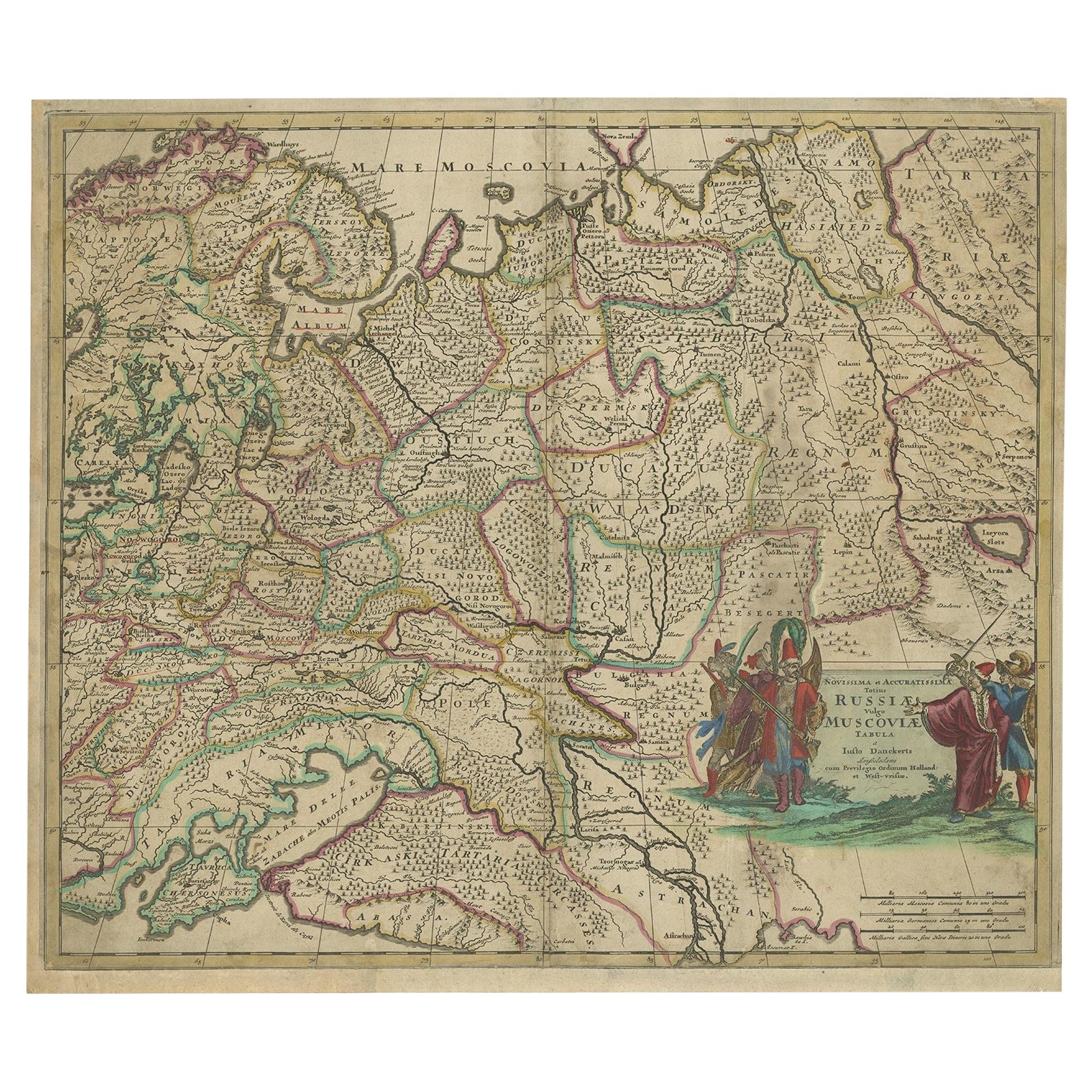
Tout afficherCarte ancienne colorée à la main de la Russie occidentale et de l'Ukraine, vers 1680
Description : Carte ancienne intitulée "Novissima et Accuratissima Totius Russiae vulgo Muscoviae Tabula".
Carte ancienne de la Russie occidentale et de l'Ukraine, publiée par Just...
Catégorie
Antiquités, 1680, Cartes
Matériaux
Papier
600 € Prix de vente
20 % de remise
Carte ancienne de la Russie occidentale par Covens & Mortier, 1740
Carte ancienne intitulée "Carte de Moscovie". Carte ancienne de la partie occidentale de la Russie. La carte est centrée sur Moscou (en haut de la feuille inférieure) et s'étend de l...
Catégorie
Antiquités, Milieu du XVIIIe siècle, Cartes
Matériaux
Papier

760 € Prix de vente
20 % de remise
Carte ancienne de Poméranie par Schenk, vers 1750
Le "Ducatus Pomeraniae" est une carte historique représentant le duché de Poméranie, une région située à cheval sur la frontière moderne entre le nord-est de l'Allemagne et la Pologn...
Catégorie
Antiquités, Milieu du XVIIIe siècle, Néerlandais, Cartes
Matériaux
Papier

400 € Prix de vente
20 % de remise
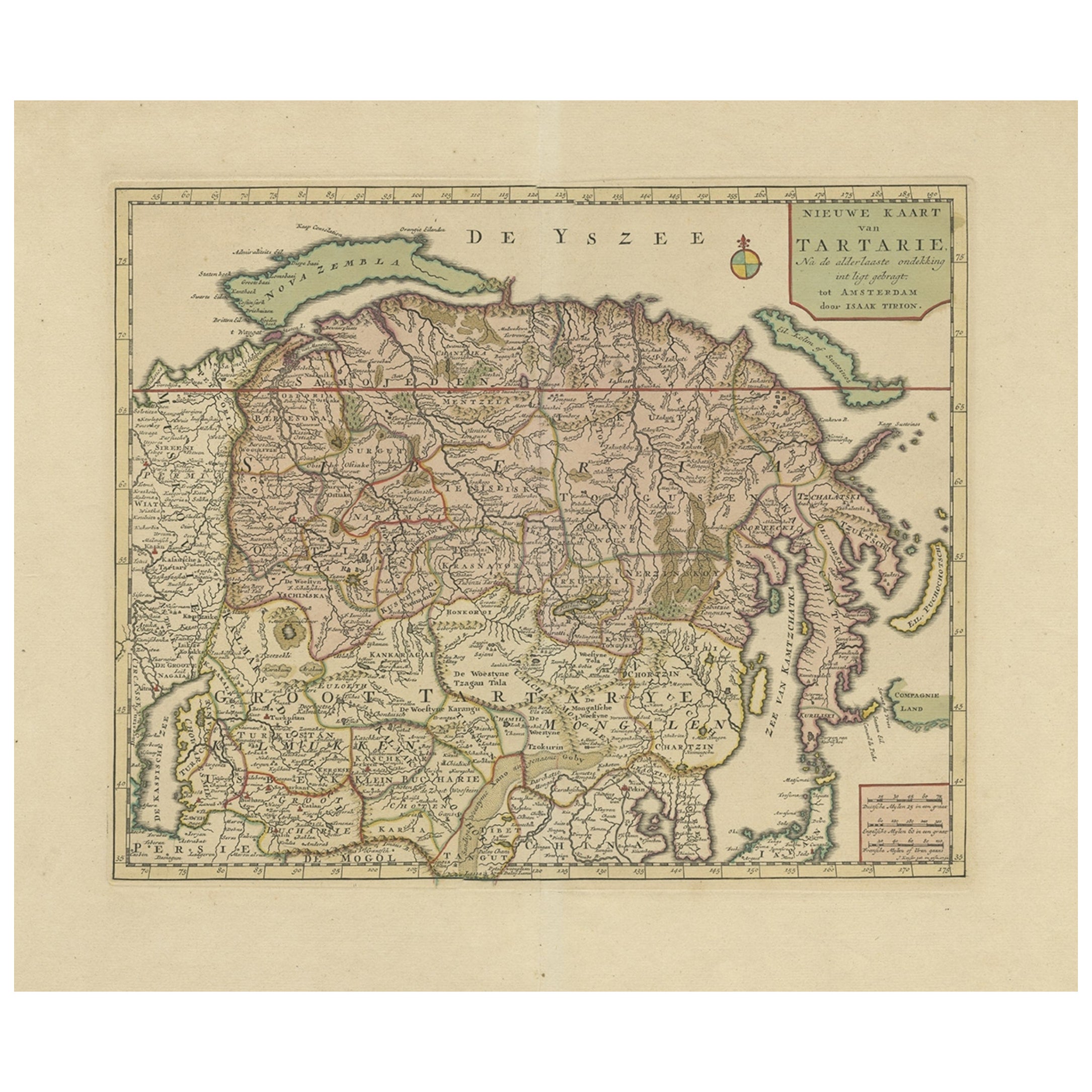
Carte ancienne de la Sibérie et de la Tartarie chinoise, Incl Nova Zembla, vers 1732
Carte ancienne de la Tartarie intitulée "Nieuwe Kaart van Tartarie na de alderlaatste ondekking int ligt gebracht tot Amsterdam door Isaak Tirion".
Carte de la Sibérie et de la T...
Catégorie
Antiquités, années 1730, Cartes
Matériaux
Papier
688 € Prix de vente
20 % de remise
Livraison gratuite
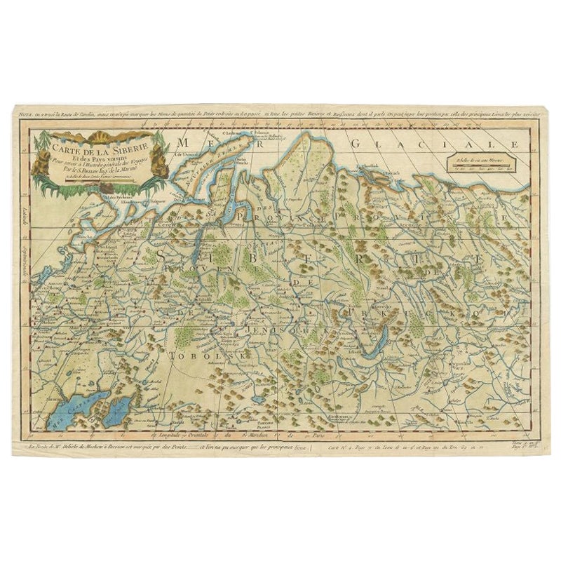
Carte ancienne de la Sibérie par Bellin, 1754
Carte ancienne intitulée "Carte de la Siberie". Carte détaillée de la Sibérie, qui s'étend de la mer Blanche et de la mer Caspienne à l'ouest jusqu'à la province de Whiting, Jakutky ...
Catégorie
Antiquités, XVIIIe siècle, Cartes
Matériaux
Papier
280 € Prix de vente
20 % de remise
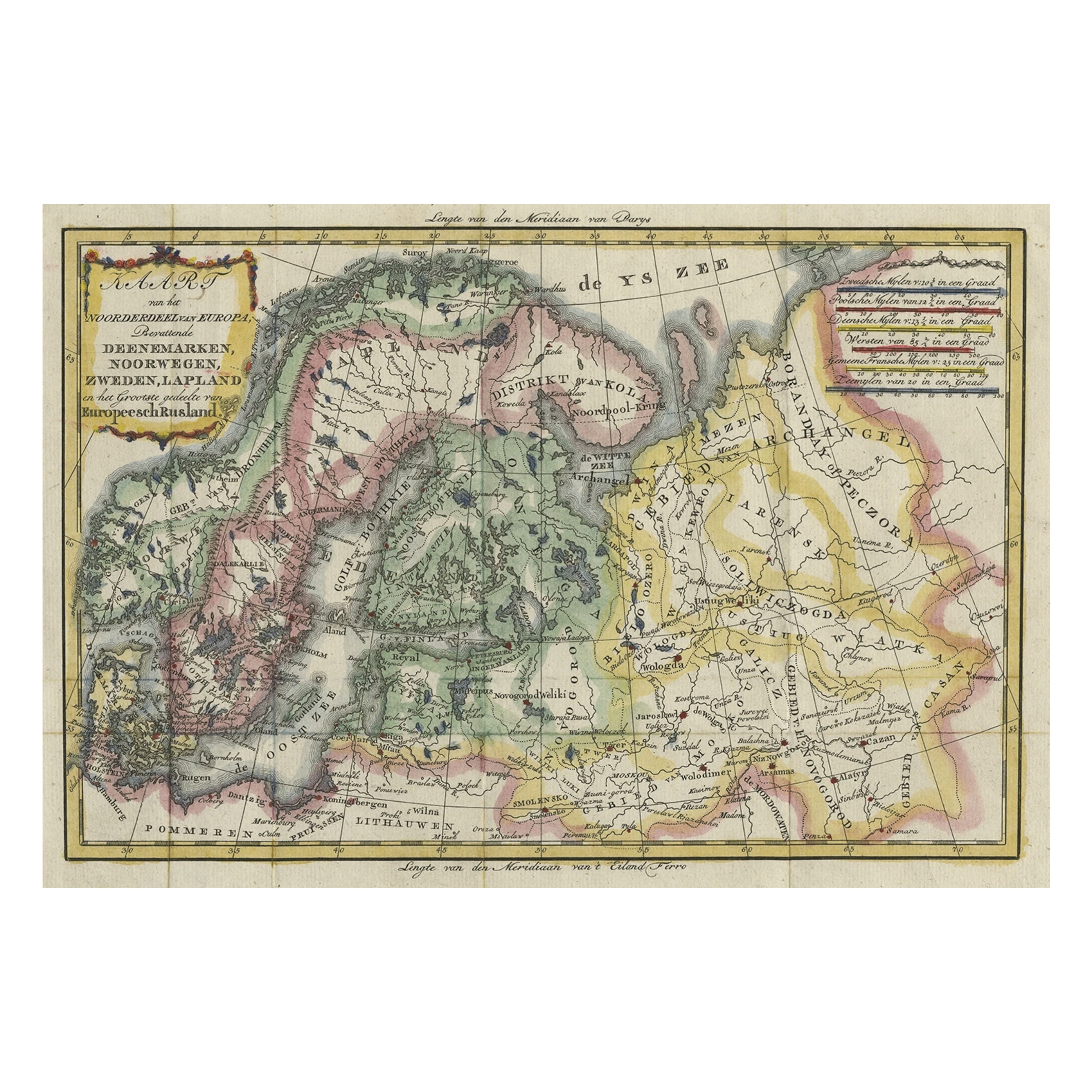
Carte ancienne peu commune de la Lapland à la Russie et du Danemark à Kazan dans le Sud, 1785
Description : Carte ancienne intitulée "Kaart van het Noorderdeel van Europa, Bevattende Deenmarken, Noorwegen, Zweden, Lapland en het Grootste Gedeelte van Europeesch Rusland"
C...
Catégorie
Antiquités, années 1780, Cartes
Matériaux
Papier
440 € Prix de vente
20 % de remise
Suggestions
Carte de l'Empire russe : une carte originale du 18e siècle colorée à la main par E. Bowen
Il s'agit d'une carte originale du XVIIIe siècle, coloriée à la main, intitulée "A New & Accurate Map of The Whole Russian Empire, As Contain'd Both In Europe and Asia, Drawn from Au...
Catégorie
Milieu du XVIIIe siècle, Maîtres anciens, Estampes - Paysage
Matériaux
Gravure

Carte ancienne - Poli Arctici ( Carte des pôles) - gravure de Johannes Janssonius - années 1650
Par Johannes Janssonius
Poli Arctici est une carte ancienne réalisée en 1650 par Johannes Janssonius (1588-1664).
La carte est une gravure à l'eau-forte coloriée à la main, avec aquarelle au même moment.
...
Catégorie
années 1650, Moderne, Estampes - Figuratif
Matériaux
Eau-forte

Carte de Thomas Stackhouse de 1790, intitulée « Russie en Europe, », Ric.a004
1790 Carte de Thomas Stackhouse, intitulée
"La Russie en Europe
Ric.a004
Stackhouse, Thomas
La Russie en Europe [carte]
Londres : AT&T, 1783. Carte. Gravure sur cuivre color...
Catégorie
Antiquités, 17ème siècle, Inconnu, Cartes
Matériaux
Papier

Carte de 1646 Jansson intitulée « Procinvia Connactiae », Ric.a006
1646 Carte de Jansson intitulée
"Procinvia connactiae,"
Ric.a006
Description : La PROVINCE de CONNAVGT 490 x 380Du vol 4 de l'Atlas Novus de Jansson 1646, publié à Amsterdam a...
Catégorie
Antiquités, 17ème siècle, Inconnu, Cartes
Matériaux
Papier

Tabula Russia Vulgo Moscovia - Gravure de Frederick de Wit - 1680ca
Par Frederick de Wit
Cette eau-forte à double page et coloriage contemporain, intitulée Tabula Russia vulgo Moscovia, a été réalisée par le cartographe Frederick de Wit pour le célèbre Atlas publié à Ams...
Catégorie
1680, Moderne, Estampes - Figuratif
Matériaux
Eau-forte
Carte de 1657 Janssonius représentant Vermandois et Cappelle, Ric. A-004
1657 Carte de Janssonius de
Vermandois et Cappelle
Ric.a004
Description : Carte ancienne de France intitulée "Descriptio Veromanduorum - Gouvernement de la Cappelle". Deux car...
Catégorie
Antiquités, 17ème siècle, Inconnu, Cartes
Matériaux
Papier
