Articles similaires à Carte originale du Brabant espagnol avec les quartiers de Bruxelles, Louvain et Anvers, c.1684


Vous voulez plus d'images ou de vidéos ?
Demander au vendeur plus d'images ou de vidéos
1 sur 10
Carte originale du Brabant espagnol avec les quartiers de Bruxelles, Louvain et Anvers, c.1684
1 400 €TVA incluse
À propos de cet article
Spanish Brabant map with Brussels, Louvain, and Antwerp quarters, c.1690
Description:
This richly detailed antique map depicts the historical region of Spanish Brabant, focusing on the key quarters of Brussels, Louvain, and Antwerp. It stretches from the western towns of Ghent and Oudenaarde and follows the course of the Escaut (Scheldt) River eastward toward Antwerp and the borders of the Prince-Bishopric of Liège. The map is centered around the cities of Brussels and Louvain, with Antwerp prominently displayed to the north.
This edition, produced by Alexis-Hubert Jaillot around 1684, is based on earlier cartographic work by Nicolas Sanson, one of the most respected French geographers of the 17th century. Jaillot, known for his grand-format maps and elaborate decoration, has preserved Sanson's geographic accuracy while enhancing the visual presentation with hand-colored borders, artistic cartouches, and fine engraving.
What makes this map particularly interesting for collectors and historians is the view it offers into the Spanish Netherlands during a time of complex political control and territorial division. Cities are clearly marked in red, and forested regions and rivers are carefully rendered. The map is a valuable record of how borders, towns, and administrative regions were understood at the end of the 17th century, just before the Treaty of Utrecht reshaped much of this area.
For buyers interested in the Low Countries, this map is a remarkable window into a pivotal historical era. It’s also a compelling decorative piece thanks to its well-balanced composition, ornate title cartouches, and vibrant hand-coloring. The inclusion of scale bars in multiple units and detailed town networks makes it useful for both research and display.
Condition:
Very good condition with strong color and sharp detail. Minor age toning consistent with age. Wide margins preserved on all sides. No visible tears, creases, or repairs.
Framing tips:
This map would be best presented in a classic wooden or gold-leaf frame, paired with an off-white or cream-colored acid-free mat to highlight the color accents. To preserve the delicate hand-coloring, UV-protective glass is recommended. Due to its rectangular horizontal orientation and detailed design, this map works well in a study, office, or hall where it can be viewed up close. Consider float mounting if you wish to showcase the map’s full plate line and paper texture.
- Dimensions:Hauteur : 47 cm (18,51 po)Largeur : 62,5 cm (24,61 po)Profondeur : 0,2 mm (0,01 po)
- Matériaux et techniques:Papier,Gravé
- Lieu d'origine:
- Période:Fin du XVIIe siècle
- Date de fabrication:1684
- État:Very good condition with strong color and sharp detail. Minor age toning consistent with age. Wide margins preserved on all sides. No visible tears, creases, or repairs.
- Adresse du vendeur:Langweer, NL
- Numéro de référence:Vendeur : BG-14068-41stDibs : LU3054345401972
À propos du vendeur
5,0
Vendeur reconnu
Ces vendeurs prestigieux sont des leaders du secteur. Ils représentent le summum en matière de qualité et de design.
Vendeur Platine
Vendeurs premium dont la note est supérieure à 4,7 et le délai de réponse de 24 heures maximum
Établi en 2009
Vendeur 1stDibs depuis 2017
2 654 ventes sur 1stDibs
Temps de réponse habituel : <1 heure
- ExpéditionRecherche du devis...Expédition depuis : Langweer, Pays-Bas
- Politique des retours
Certaines parties de cette page ont été traduites automatiquement. 1stDibs ne garantit pas l'exactitude des traductions. L'anglais est la langue par défaut de ce site web.
Garantie d'authenticité
Bien qu'il soit peu probable que la situation se présente, dans le cas où vous rencontreriez un problème d'authenticité d'un article, contactez-nous dans un délai d'un an pour obtenir un remboursement intégral. DétailsGarantie de remboursement
Si votre article n'est pas conforme à la description, est endommagé pendant le transport ou ne vous est pas livré, contactez-nous sous 7 jours pour obtenir un remboursement intégral. DétailsAnnulation sous 24 heures
Vous disposez d'un délai de 24 heures pour annuler votre achat sans motif.Des vendeurs professionnels agréés
Nos vendeurs de renommée mondiale doivent respecter des normes strictes en matière de service et de qualité, afin de préserver l'intégrité de nos fiches produit.Garantie d'alignement des prix
Si vous constatez qu'un autre vendeur a mis en vente le même article à un prix inférieur sur un autre site, nous nous alignerons sur ce prix.Livraison en toute confiance à l'international
Notre réseau de transporteurs de premier ordre propose des options d'expédition spécialisées dans le monde entier, y compris des livraisons personnalisées.Plus d'articles de ce vendeur
Tout afficherCarte ancienne de Belgique et d'entourages, 1692
Carte ancienne intitulée "Provincie Meridionali de Paesi Bassi Intese sotto nome di Fiandra overo Li Paesi Bassi Cattolici con li confini di Francia di Allemagna et di Hollanda". Car...
Catégorie
Antiquités, 17ème siècle, Cartes
Matériaux
Papier

340 € Prix de vente
20 % de remise
Carte ancienne de la région du Hainaut et de Namur par Janssonius:: "vers 1640"
Par Johannes Janssonius
Carte ancienne intitulée "Comitatuum Hannoniae et Namurci Descriptio". Ancienne carte de la région du Hainaut et de Namur, France. Publié par J. Janssonius, vers 1640.
Catégorie
Antiquités, Milieu du XVIIe siècle, Cartes
Matériaux
Papier

400 € Prix de vente
20 % de remise
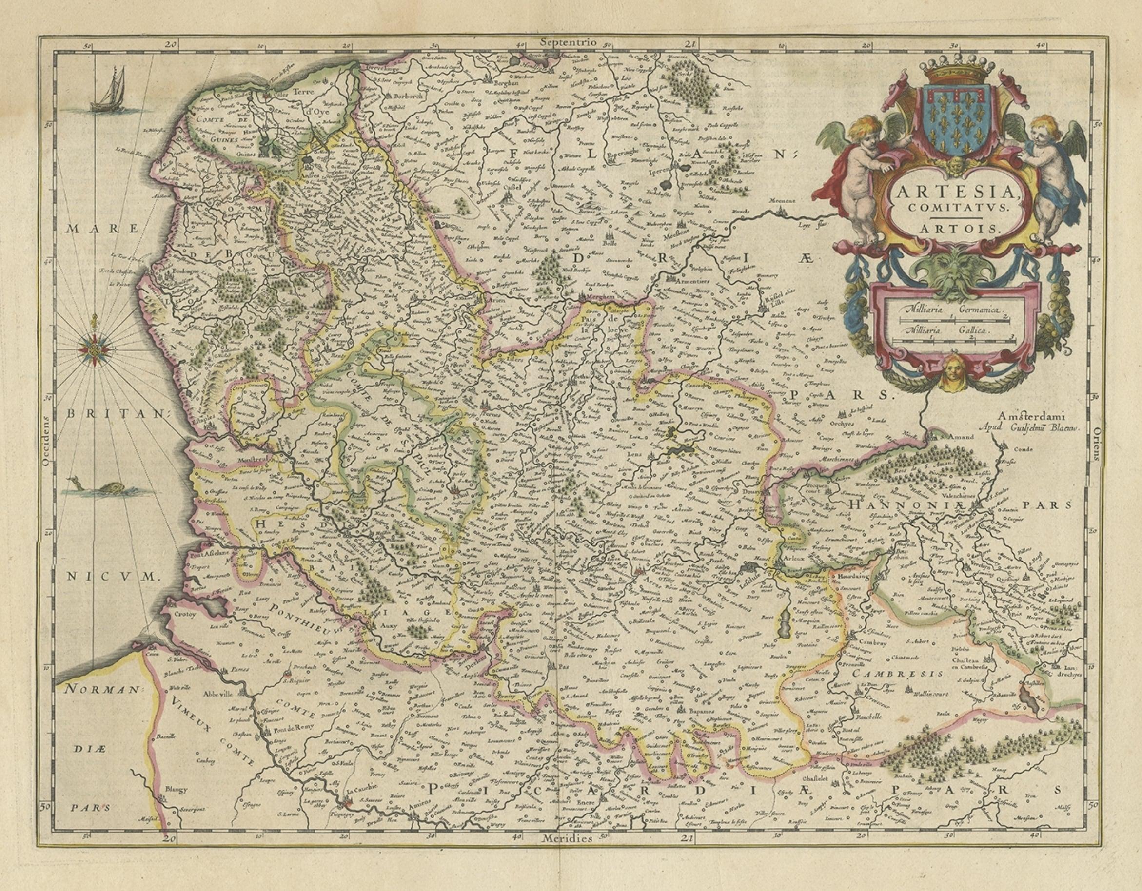
Carte ancienne d'Artois dans le nord de la France par le célèbre ébéniste Blaeu, vers 1640
Carte ancienne intitulée "ARTESIA Comitatus Artois". Carte de l'ARTESIA ou de l'ARTESIA, France. L'Artois est une ancienne province située dans la partie nord-ouest de la France, bor...
Catégorie
Antiquités, 17ème siècle, Cartes
Matériaux
Papier
384 € Prix de vente
20 % de remise
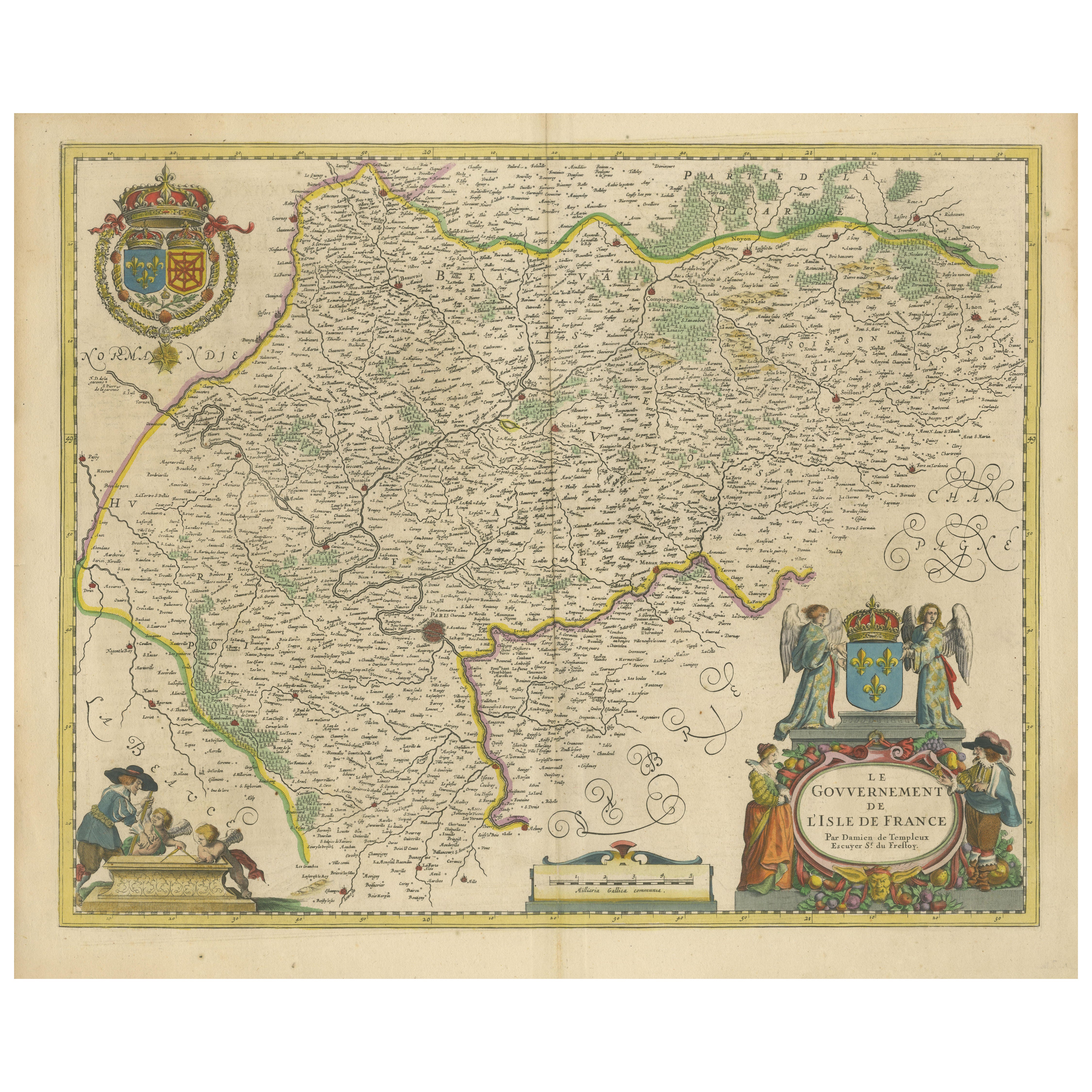
Magnifique carte de Paris et de l'île de France du 17ème siècle par Templeux, vers 1650
Carte de l'Isle de France par D. de Templeux, vers 1650, coloriée à la main et décorative
Cette carte ancienne richement détaillée intitulée *Le Gouvernement de L'Isle de France* a ...
Catégorie
Antiquités, années 1650, Cartes
Matériaux
Papier

Carte ancienne du comté d'Hainaut par Jaillot, 1692
Carte ancienne intitulée "Le Comté de Haynaut divisé en Chateliensis, Balliages, Prevoste's (...)". Grande carte du comté de Hainaut (France) avec ses villes les plus importantes, Mo...
Catégorie
Antiquités, 17ème siècle, Cartes
Matériaux
Papier

178 € Prix de vente
20 % de remise
The Antiquities Map of the Hainaut Region 'France' by F. de Wit, circa 1680
Carte ancienne intitulée "Comitatus Hannoniae et Episcopatus Cambresis Descriptio". Grande carte de la région du Hainaut, France. Publié par F. de Wit, vers 1680.
Catégorie
Antiquités, Fin du XVIIe siècle, Cartes
Matériaux
Papier

460 € Prix de vente
20 % de remise
Suggestions
Carte de Willem Blaeu de la France du Nord « Comitatvs Bellovacvm » Ric.a08
1635 Carte de Willem Blaeu du nord de la France, intitulée.
"Comitatvs Bellovacvm Vernacule Beavvais,"
Coloré
Ric.a008
"COMITATVS BELLOVACVM......
Catégorie
Antiquités, 17ème siècle, Inconnu, Cartes
Matériaux
Papier

Allemagne de l'Ouest : carte originale du XVIIe siècle colorée à la main par Johannes Janssonius
Par Johannes Janssonius
Carte originale gravée sur cuivre et colorée à la main, intitulée en latin "Archiepiscopatus Maghdeburgensis et Anhaltinus Ducatus cum terris adjacentibus", publiée à Amsterdam en 16...
Catégorie
Milieu du XVIIe siècle, Maîtres anciens, Plus d'Estampes
Matériaux
Gravure

1643 Carte Willem&Joan Blaeu NW Flanders ""Flandriae Teutonicae Pars Prientalior
1643 Carte de Willem et Joan Blaeu du nord-ouest de la Flandre, intitulée
"Flandriae Teutonicae Pars Prientalior,"
Ric0012
" Authentique " - Carte de la Flandre du nord-ouest, ...
Catégorie
Antiquités, 17ème siècle, Néerlandais, Cartes
Matériaux
Papier

Carte de Joan Bleau de 1640 intitulée "Diocecese de rheims et le pais de rethel", Eic.a011
1640 Carte de Joan Bleau intitulée
"Diocecese de rheims et le pais de rethel,"
Ric.a011
OAN BLAEU
Diocecese de Rheims, et le pais de Rethel.
Gravure coloriée à la main...
Catégorie
Antiquités, 17ème siècle, Néerlandais, Cartes
Matériaux
Papier

1752 Carte de Vaugoundy des Flandres : Belgique, France et Pays-Bas, Ric.a002
Grande carte des Flandres de Vaugoundy :
Belgique, France et Pays-Bas
Coloré -1752
Ric.a002
Description : Il s'agit d'une carte des Flandres de Didier Robert de Vaugondy de 1...
Catégorie
Antiquités, 17ème siècle, Inconnu, Cartes
Matériaux
Papier

Carte 1633 intitulée « Beauvaisis Comitatus Belova Cium, Ric.0002 »
carte de 1633 intitulée
"Beauvaisis Comitatus Belova Cium,"
Coloré à la main
Ric.0002
Description : Cartographe : - Hondius, Henricus 1587-1638
Artistes et graveurs : ...
Catégorie
Antiquités, 17ème siècle, Néerlandais, Cartes
Matériaux
Papier
