Articles similaires à Explore North America in 1903 - Intricately Detailed Antique Map


Vous voulez plus d'images ou de vidéos ?
Demander au vendeur plus d'images ou de vidéos
1 sur 10
Explore North America in 1903 - Intricately Detailed Antique Map
À propos de cet article
North America, 1903 - A Colorful Historical Map with Detailed Borders
This attractive map of North America was engraved, printed, and published by W. & A.K. Johnston in 1903. A wonderful example of early 20th-century cartography, it captures the complex geography and political divisions of Canada, the United States, Mexico, Central America, the Caribbean, and the Arctic regions in a detailed and colorful presentation.
The map is filled with fascinating details, including major cities, rivers, mountain ranges, and railway lines that crisscrossed the continent at the time. Political boundaries are clearly marked in different colors, distinguishing the various countries and regions. The northern reaches of Canada and Alaska are depicted with impressive accuracy for the era, as are the Caribbean islands and Central American states.
The bright yet subtle color palette—red for borders, blue for water, and a gentle green for mountain shading—makes this map visually appealing and easy to read. The map also includes detailed insets and a clear legend showing the scale and distances, making it a valuable reference for historians and collectors interested in the evolution of North America’s borders.
Condition report:
This map is in very good condition, with some minor foxing and small creases typical of antique maps. The paper is strong, and the colors remain clear and vibrant.
Framing tips:
This historical map would look splendid in a black or dark wood frame, perhaps with a white or cream mat to highlight the soft colors. A museum-quality glass can protect the map while preserving the crisp details and ensuring a long-lasting display in an office, library, or living room.
- Dimensions:Hauteur : 47 cm (18,51 po)Largeur : 36,8 cm (14,49 po)Profondeur : 0,2 mm (0,01 po)
- Matériaux et techniques:
- Période:
- Date de fabrication:1903
- État:This map is in very good condition, with some minor foxing and small creases typical of antique maps. The paper is strong, and the colors remain clear and vibrant.
- Adresse du vendeur:Langweer, NL
- Numéro de référence:Vendeur : BG-13577-401stDibs : LU3054345291442
À propos du vendeur
5,0
Vendeur reconnu
Ces vendeurs prestigieux sont des leaders du secteur. Ils représentent le summum en matière de qualité et de design.
Vendeur Or
Vendeurs premium dont la note est supérieure à 4,3 et le délai de réponse de 24 heures maximum
Établi en 2009
Vendeur 1stDibs depuis 2017
2 462 ventes sur 1stDibs
Temps de réponse habituel : <1 heure
- ExpéditionRecherche du devis...Expédition depuis : Langweer, Pays-Bas
- Politique des retours
Certaines parties de cette page ont été traduites automatiquement. 1stDibs ne garantit pas l'exactitude des traductions. L'anglais est la langue par défaut de ce site web.
Garantie d'authenticité
Bien qu'il soit peu probable que la situation se présente, dans le cas où vous rencontreriez un problème d'authenticité d'un article, contactez-nous dans un délai d'un an pour obtenir un remboursement intégral. DétailsGarantie de remboursement
Si votre article n'est pas conforme à la description, est endommagé pendant le transport ou ne vous est pas livré, contactez-nous sous 7 jours pour obtenir un remboursement intégral. DétailsAnnulation sous 24 heures
Vous disposez d'un délai de 24 heures pour annuler votre achat sans motif.Des vendeurs professionnels agréés
Nos vendeurs de renommée mondiale doivent respecter des normes strictes en matière de service et de qualité, afin de préserver l'intégrité de nos fiches produit.Garantie d'alignement des prix
Si vous constatez qu'un autre vendeur a mis en vente le même article à un prix inférieur sur un autre site, nous nous alignerons sur ce prix.Livraison en toute confiance à l'international
Notre réseau de transporteurs de premier ordre propose des options d'expédition spécialisées dans le monde entier, y compris des livraisons personnalisées.Plus d'articles de ce vendeur
Tout afficherAntique Map of Asia with Intricate Provincial Boundaries, Published in 1903
Title: Antique Map of Asia, 1903, with Intricate Provincial Boundaries and Coastal Features
Description:
This antique map, titled "Asia," was engraved and published in 1903 by the r...
Catégorie
Début du 20ème siècle, Cartes
Matériaux
Papier

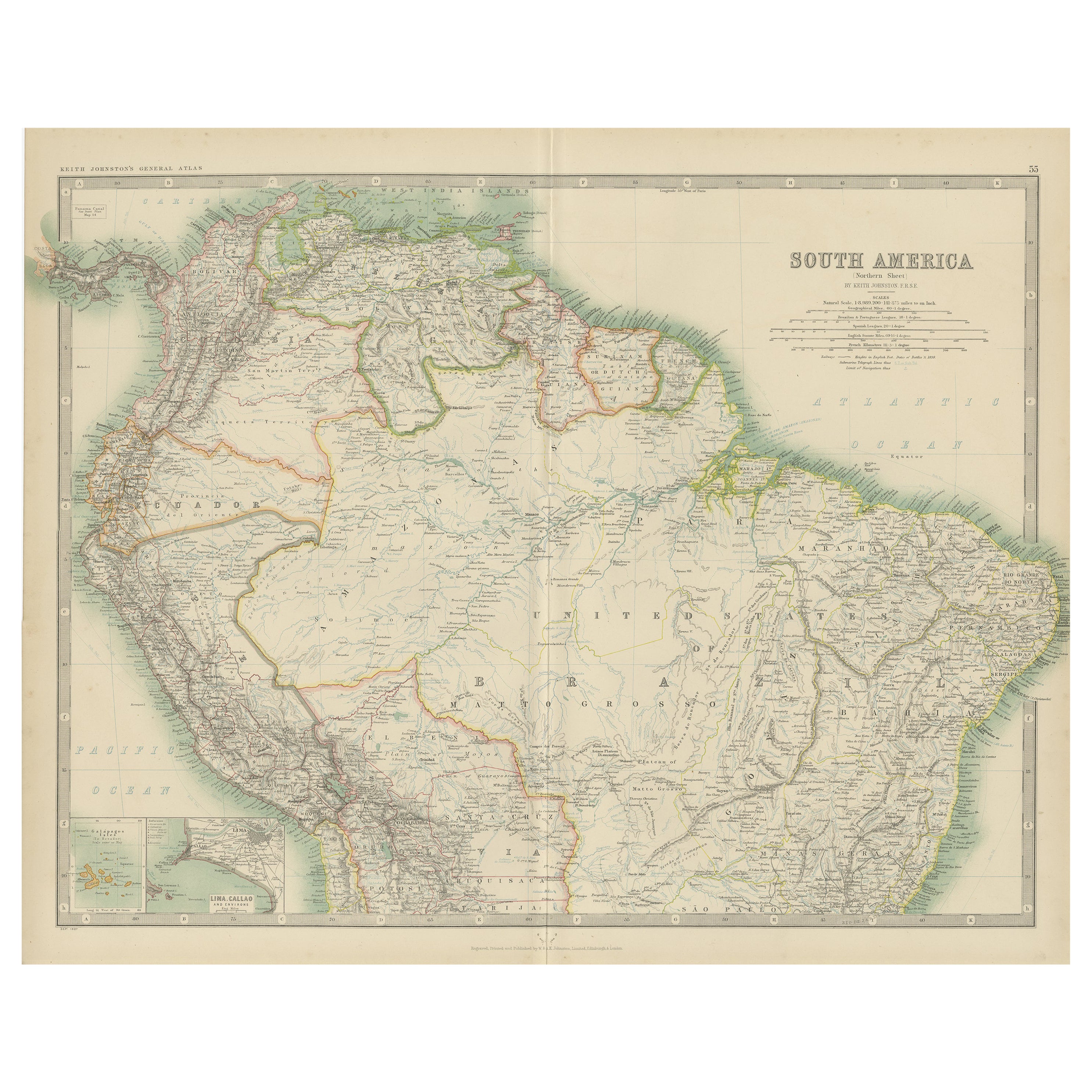
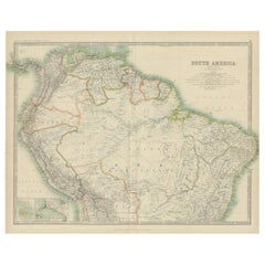
Exploration du Nord de l'Amérique du Sud : carte ancienne du Royal Atlas de 1909
La carte ancienne intitulée "Amérique du Sud, feuille nord" est une représentation cartographique historique de la partie nord de l'Amérique du Sud. Cette carte ancienne originale co...
Catégorie
Début du 20ème siècle, Cartes
Matériaux
Papier
232 $US Prix de vente
20 % de remise
Antique Map of Northern Scotland, 1903, with Intricate Coastal Features
Title: Antique Map of Northern Scotland and Islands, 1903, with Intricate Coastal Features
Description:
This striking antique map, titled "Scotland (Northern Sheet I)," was engraved...
Catégorie
Début du 20ème siècle, Cartes
Matériaux
Papier

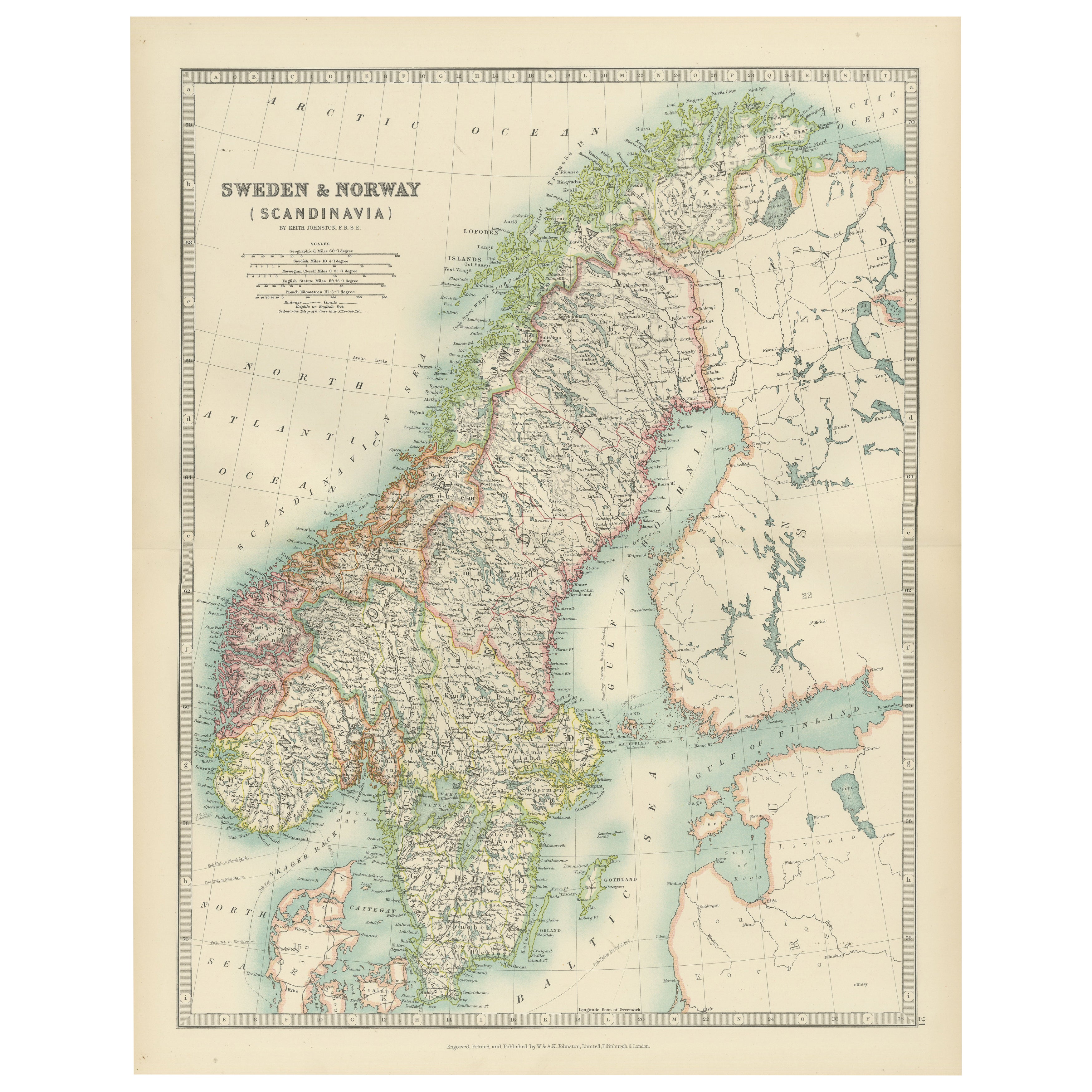
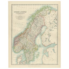
Antique Map of Sweden & Norway, 1903, with Intricate Topographical Detail
Title: Antique Map of Sweden & Norway, 1903, with Intricate Topographical Detail
Description:
This antique map, titled "Sweden & Norway (Scandinavia)," was engraved and published in...
Catégorie
Début du 20ème siècle, Cartes
Matériaux
Papier
Carte ancienne d'Amérique du Nord, 1821
Carte ancienne de l'Amérique intitulée "Carte de l'Amérique septentrionale". Carte rare de l'Amérique du Nord, peu après l'achat de la Louisiane et la première publication du rapport...
Catégorie
Antiquités, XIXe siècle, Cartes
Matériaux
Papier

604 $US Prix de vente
20 % de remise
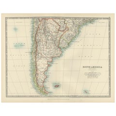
Map of Southern South America – Richly Detailed Engraving by K.Johnston, 1903
Title (80 characters, keyword-first):
Map of Southern South America – Richly Detailed Engraving by Keith Johnston, 1903
Description:
This elegant map titled "South America: Southern...
Catégorie
Début du 20ème siècle, Cartes
Matériaux
Papier
Suggestions
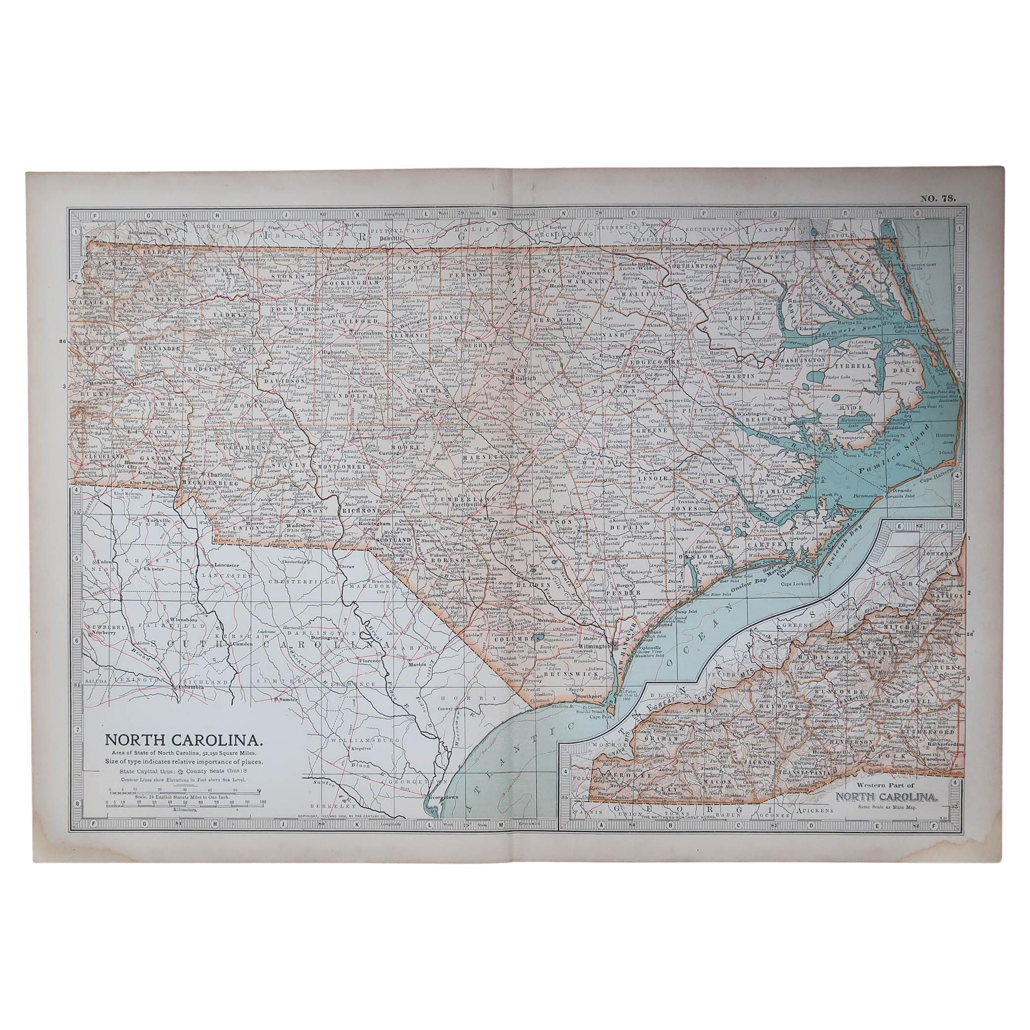
Carte ancienne originale de l'État américain de Caroline du Nord, 1903
Antique map of North Carolina
Published By A & C Black. 1903
Original colour
Good condition
Unframed.
Free shipping
Catégorie
Antiquités, Début des années 1900, Anglais, Cartes
Matériaux
Papier

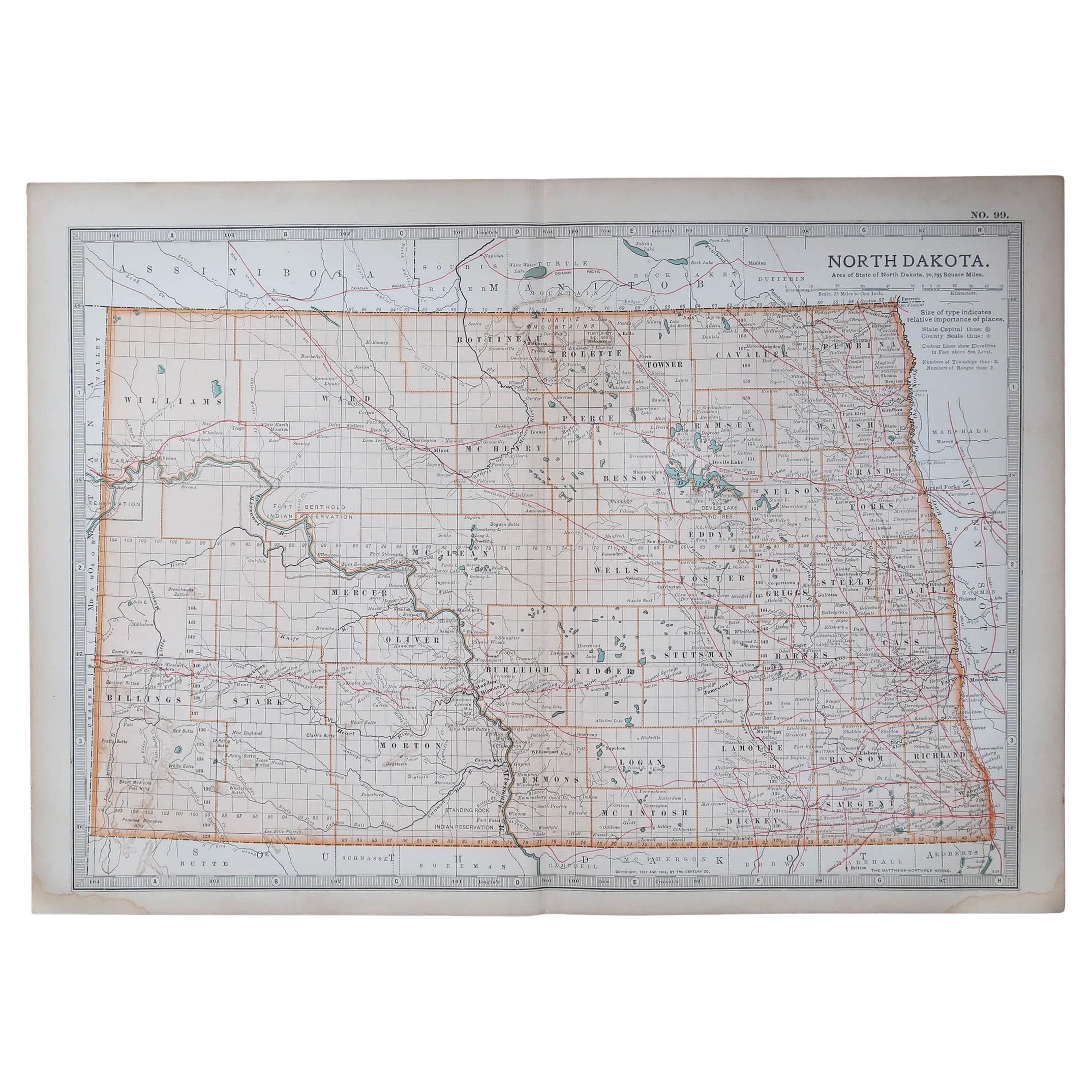
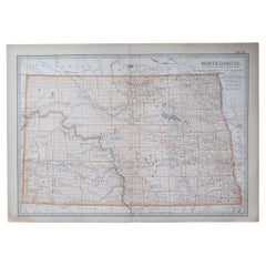
Carte ancienne de l'État américain du Dakota du Nord, 1903
Carte ancienne du Dakota du Nord
Publié par A.I.C Black. 1903
Couleur originale
Bon état
Sans cadre.
Expédition gratuite
Catégorie
Antiquités, Début des années 1900, Anglais, Cartes
Matériaux
Papier
Carte ancienne de l'État américain du Minnesota, 1903
Carte ancienne du Minnesota
Publié par A.I.C Black. 1903
Couleur originale
Bon état
Sans cadre.
Expédition gratuite
Catégorie
Antiquités, Début des années 1900, Anglais, Cartes
Matériaux
Papier

Carte ancienne de l'État américain de l'Alabama, 1903
Antique map of Alabama
Published By A & C Black. 1903
Original colour
Good condition
Unframed.
Free shipping
Catégorie
Antiquités, Début des années 1900, Anglais, Cartes
Matériaux
Papier

Carte ancienne de l'État américain de l'Alaska, 1903
Carte ancienne de l'Alaska
Publié par A.I.C Black. 1903
Couleur originale
Bon état
Sans cadre.
Expédition gratuite
Catégorie
Antiquités, Début des années 1900, Anglais, Cartes
Matériaux
Papier

Carte ancienne de l'État américain du Nebraska, 1903
Carte ancienne du Nebraska
Publié par A.I.C Black. 1903
Couleur originale
Bon état
Sans cadre.
Expédition gratuite
Catégorie
Antiquités, Début des années 1900, Anglais, Cartes
Matériaux
Papier
