Articles similaires à Map of Aube France with Troyes and Champagne Wine Region, 19th Century


Vous voulez plus d'images ou de vidéos ?
Demander au vendeur plus d'images ou de vidéos
1 sur 10
Map of Aube France with Troyes and Champagne Wine Region, 19th Century
120 €TVA incluse
À propos de cet article
Map of Aube France with Troyes and Champagne Vineyards by Vuillemin, 19th c
Description:
This 19th-century map of the Aube department in the Grand Est region of northeastern France was engraved by Alexandre Vuillemin and published by Migeon in Paris as part of the Nouvel Atlas Illustré. Combining fine cartography with historical and cultural illustration, the map offers a visual journey through one of France’s most historically rich and agriculturally significant regions.
Aube is part of the historic Champagne region, and the map clearly displays its towns, rivers, and roadways, all bordered in hand-applied pastel pink. The capital city of Troyes is prominently positioned at the center, surrounded by a dense network of communes. To the right, a finely engraved vignette shows the town of Nogent-sur-Seine, situated along the banks of the river, offering a calm and picturesque atmosphere.
Two prominent portraits are featured in the lower left corner: Denis Diderot, the Enlightenment philosopher and editor of the Encyclopédie, who was born in Langres just outside Aube but is associated with the regional intellectual landscape; and Georges Cuvier, a pioneering naturalist who laid the foundations for paleontology. Their inclusion highlights the region’s contribution to French intellectual and scientific advancement.
Aube plays a major role in France’s wine culture as part of the southern Champagne-producing area. The Côte des Bar, located in the southern part of Aube, is especially known for producing high-quality Pinot Noir grapes, crucial for blending in Champagne production. While less internationally known than the vineyards of Reims and Épernay to the north, the vineyards around Bar-sur-Seine and Bar-sur-Aube have gained increasing recognition for their elegant and expressive sparkling wines.
Alexandre Vuillemin was a leading 19th-century French cartographer celebrated for merging technical accuracy with decorative and educational value. His maps are valued today for their aesthetic qualities and insight into the political and cultural geography of the time. The publisher Migeon specialized in illustrated educational works, bringing finely engraved atlases to a broad audience.
Condition summary:
Very good condition with minimal toning and a few scattered foxing spots, mostly confined to the margins. Original hand coloring remains vibrant and the engraving is clear and sharp.
Framing tips:
This map pairs well with a dark or gold-toned frame. A soft beige or off-white mat will complement the pink border color and engraved details. Use UV-filtering glass for preservation and to maintain the crispness of the print.
- Dimensions:Hauteur : 26,1 cm (10,28 po)Largeur : 32,5 cm (12,8 po)Profondeur : 0,2 mm (0,01 po)
- Matériaux et techniques:Papier,Gravé
- Lieu d'origine:
- Période:
- Date de fabrication:circa 1850
- État:Very good condition with minimal toning and a few scattered foxing spots, mostly confined to the margins. Original hand coloring remains vibrant and the engraving is clear and sharp.
- Adresse du vendeur:Langweer, NL
- Numéro de référence:Vendeur : BG-13331-91stDibs : LU3054345359582
À propos du vendeur
5,0
Vendeur reconnu
Ces vendeurs prestigieux sont des leaders du secteur. Ils représentent le summum en matière de qualité et de design.
Vendeur Platine
Vendeurs premium dont la note est supérieure à 4,7 et le délai de réponse de 24 heures maximum
Établi en 2009
Vendeur 1stDibs depuis 2017
2 641 ventes sur 1stDibs
Temps de réponse habituel : <1 heure
- ExpéditionRecherche du devis...Expédition depuis : Langweer, Pays-Bas
- Politique des retours
Certaines parties de cette page ont été traduites automatiquement. 1stDibs ne garantit pas l'exactitude des traductions. L'anglais est la langue par défaut de ce site web.
Garantie d'authenticité
Bien qu'il soit peu probable que la situation se présente, dans le cas où vous rencontreriez un problème d'authenticité d'un article, contactez-nous dans un délai d'un an pour obtenir un remboursement intégral. DétailsGarantie de remboursement
Si votre article n'est pas conforme à la description, est endommagé pendant le transport ou ne vous est pas livré, contactez-nous sous 7 jours pour obtenir un remboursement intégral. DétailsAnnulation sous 24 heures
Vous disposez d'un délai de 24 heures pour annuler votre achat sans motif.Des vendeurs professionnels agréés
Nos vendeurs de renommée mondiale doivent respecter des normes strictes en matière de service et de qualité, afin de préserver l'intégrité de nos fiches produit.Garantie d'alignement des prix
Si vous constatez qu'un autre vendeur a mis en vente le même article à un prix inférieur sur un autre site, nous nous alignerons sur ce prix.Livraison en toute confiance à l'international
Notre réseau de transporteurs de premier ordre propose des options d'expédition spécialisées dans le monde entier, y compris des livraisons personnalisées.Plus d'articles de ce vendeur
Tout afficherMap of Allier France with Saint-Pourçain Wine Region by Vuillemin, 19th c
Map of Allier France with Saint-Pourçain Wine Region by Vuillemin, 19th c
This decorative 19th-century map of Allier, a central department of France, comes from the celebrated Nouve...
Catégorie
Antiquités, Milieu du XIXe siècle, Français, Cartes
Matériaux
Papier

Map of Aude France with Carcassonne and Languedoc Vineyards, 19th Century
Map of Aude France with Carcassonne and Languedoc Vineyards, 19th Century
Description:
This elegant 19th-century map of Aude, a department in southern France along the Mediterranean...
Catégorie
Antiquités, Milieu du XIXe siècle, Français, Cartes
Matériaux
Papier

Map of Aisne France with Soissons and Champagne Vineyards by Vuillemin, 19th c
Map of Aisne France with Soissons and Champagne Vineyards by Vuillemin, 19th c
Description:
This richly detailed 19th-century engraved and hand-colored map of the department of Aisn...
Catégorie
Antiquités, Milieu du XIXe siècle, Français, Cartes
Matériaux
Papier

Map of Côtes-du-Nord France with Saint-Brieuc and Brittany Coastline, c.1850
Map of Côtes-du-Nord France with Saint-Brieuc and Brittany Coastline, 19th c
Description:
This elegant 19th-century map of Côtes-du-Nord, the historic name for what is now known as ...
Catégorie
Antiquités, Milieu du XIXe siècle, Français, Cartes
Matériaux
Papier

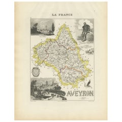
Map of Aveyron France with Rodez, Millau and Wine Routes, 19th Century
Map of Aveyron France with Rodez, Millau and Wine Routes, 19th Century
Description:
This detailed and decorative 19th-century map of Aveyron, a department in southern France, was dr...
Catégorie
Antiquités, Milieu du XIXe siècle, Français, Cartes
Matériaux
Papier
Map of Ain France with Vineyards of Bugey and Notable Portraits, c.1850
Map of Ain France with Portraits of Bichat and Joubert by Vuillemin, 19th c
This highly decorative 19th-century map of the French department of Ain is taken from the celebrated Nouv...
Catégorie
Antiquités, Milieu du XIXe siècle, Français, Cartes
Matériaux
Papier

Suggestions
Aube, France. Carte ancienne d'un département français, 1856
Par Victor Levasseur
département de l'Aube, gravure sur acier avec contour original coloré à la main, 1856, de l'Atlas national illustré de Levasseur.
Cette région de France est connue pour sa producti...
Catégorie
XIXe siècle, Naturalisme, Estampes - Paysage
Matériaux
Gravure

Aude, France. Carte ancienne d'un département français, 1856
Par Victor Levasseur
département de l'Aude, gravure sur acier avec contour original coloré à la main, 1856, de l'Atlas national illustré de Levasseur.
Cette région de France est célèbre pour sa grande ...
Catégorie
XIXe siècle, Naturalisme, Estampes - Paysage
Matériaux
Gravure

Grande carte de France du 19ème siècle
Grande carte de France du 19e siècle.
Remarquable état de conservation, avec une patine d'usage agréable.
Récemment encadré.
France Circa 1874.
Catégorie
Antiquités, Fin du XIXe siècle, Français, Cartes
Matériaux
Lin, Papier

Saone et Loire, France. Carte ancienne d'un département français, 1856
Par Victor Levasseur
département de Saône et Loire", gravure sur acier avec contour original coloré à la main, 1856, de l'Atlas national illustré de Levasseur.
Le département français de la Saône et Lo...
Catégorie
XIXe siècle, Naturalisme, Estampes - Paysage
Matériaux
Gravure

Indre and Loire, France. Carte ancienne d'un département français, 1856
Par Victor Levasseur
département d'Indre et Loire", gravure sur acier avec contour original coloré à la main, 1856, de l'Atlas national illustré de Levasseur.
Cette région est connue pour sa production...
Catégorie
XIXe siècle, Naturalisme, Estampes - Paysage
Matériaux
Gravure

Carte Bonne de Poitou, Touraine et Anjou, France, Ric.a015, 1771
1771 Bonne carte du Poitou,
Touraine et Anjou, France
Ric.a015
1771 Carte de Potiou, Touraine et Anjou intitulée "Carte des Gouvernements D'Anjou et du Saumurois, de la Tour...
Catégorie
Antiquités, 17ème siècle, Inconnu, Cartes
Matériaux
Papier
