Vous voulez plus d'images ou de vidéos ?
Demander au vendeur plus d'images ou de vidéos
1 sur 10
Map of Aude France with Carcassonne and Languedoc Vineyards, 19th Century
Prix :144,40 $US
À propos de cet article
- Dimensions:Hauteur : 26,1 cm (10,28 po)Largeur : 32,5 cm (12,8 po)Profondeur : 0,2 mm (0,01 po)
- Matériaux et techniques:Papier,Gravé
- Lieu d'origine:
- Période:
- Date de fabrication:circa 1850
- État:Very good condition with light toning around the edges and minor foxing in the margins. Engraving is crisp and the original hand coloring remains bright and clean.
- Adresse du vendeur:Langweer, NL
- Numéro de référence:Vendeur : BG-13331-101stDibs : LU3054345359612
À propos du vendeur
5,0
Vendeur reconnu
Ces vendeurs prestigieux sont des leaders du secteur. Ils représentent le summum en matière de qualité et de design.
Vendeur Platine
Vendeurs premium dont la note est supérieure à 4,7 et le délai de réponse de 24 heures maximum
Établi en 2009
Vendeur 1stDibs depuis 2017
2 641 ventes sur 1stDibs
Garantie d'authenticité
Bien qu'il soit peu probable que la situation se présente, dans le cas où vous rencontreriez un problème d'authenticité d'un article, contactez-nous dans un délai d'un an pour obtenir un remboursement intégral. DétailsGarantie de remboursement
Si votre article n'est pas conforme à la description, est endommagé pendant le transport ou ne vous est pas livré, contactez-nous sous 7 jours pour obtenir un remboursement intégral. DétailsAnnulation sous 24 heures
Vous disposez d'un délai de 24 heures pour annuler votre achat sans motif.Des vendeurs professionnels agréés
Nos vendeurs de renommée mondiale doivent respecter des normes strictes en matière de service et de qualité, afin de préserver l'intégrité de nos fiches produit.Garantie d'alignement des prix
Si vous constatez qu'un autre vendeur a mis en vente le même article à un prix inférieur sur un autre site, nous nous alignerons sur ce prix.Livraison en toute confiance à l'international
Notre réseau de transporteurs de premier ordre propose des options d'expédition spécialisées dans le monde entier, y compris des livraisons personnalisées.Suggestions
Aude, France. Carte ancienne d'un département français, 1856
Par Victor Levasseur
département de l'Aude, gravure sur acier avec contour original coloré à la main, 1856, de l'Atlas national illustré de Levasseur.
Cette région de France est célèbre pour sa grande ...
Catégorie
XIXe siècle, Naturalisme, Estampes - Paysage
Matériaux
Gravure

165 $US
H 13 po l 18,51 po
Aube, France. Carte ancienne d'un département français, 1856
Par Victor Levasseur
département de l'Aube, gravure sur acier avec contour original coloré à la main, 1856, de l'Atlas national illustré de Levasseur.
Cette région de France est connue pour sa producti...
Catégorie
XIXe siècle, Naturalisme, Estampes - Paysage
Matériaux
Gravure

165 $US
H 13 po l 18,51 po
Grande carte de France du 19ème siècle
Grande carte de France du 19e siècle.
Remarquable état de conservation, avec une patine d'usage agréable.
Récemment encadré.
France Circa 1874.
Catégorie
Antiquités, Fin du XIXe siècle, Français, Cartes
Matériaux
Lin, Papier

Saone et Loire, France. Carte ancienne d'un département français, 1856
Par Victor Levasseur
département de Saône et Loire", gravure sur acier avec contour original coloré à la main, 1856, de l'Atlas national illustré de Levasseur.
Le département français de la Saône et Lo...
Catégorie
XIXe siècle, Naturalisme, Estampes - Paysage
Matériaux
Gravure

165 $US
H 13 po l 18,51 po
Carte de la Haute Vienne - Lithographie originale - 19ème siècle
Carte de la Haute Vienne est une œuvre d'art originale en lithographie réalisée par une Graveur anonyme du 19ème siècle.
Imprimé dans la série des "France Pittoresque".
Intitulé ...
Catégorie
XIXe siècle, Moderne, Estampes - Figuratif
Matériaux
Lithographie

553 $US
H 6,7 po l 9,06 po P 0,08 po
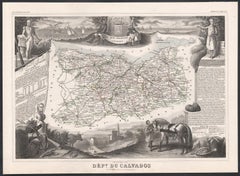
Calvados, France. Carte ancienne d'un département français, 1856
Par Victor Levasseur
Dept. du Calvados", gravure sur acier avec contour original coloré à la main, 1856, tirée de l'"Atlas National Illustre" de Levasseur.
Cette région de France est connue pour sa pro...
Catégorie
XIXe siècle, Naturalisme, Estampes - Paysage
Matériaux
Gravure
165 $US
H 13 po l 18,51 po
Indre and Loire, France. Carte ancienne d'un département français, 1856
Par Victor Levasseur
département d'Indre et Loire", gravure sur acier avec contour original coloré à la main, 1856, de l'Atlas national illustré de Levasseur.
Cette région est connue pour sa production...
Catégorie
XIXe siècle, Naturalisme, Estampes - Paysage
Mat�ériaux
Gravure

165 $US
H 18,51 po l 13 po
Carte des deux Svres - gravure originale - 19ème siècle
Carte des Deux Sèvres est une gravure originale ancienne réalisée par un graveur anonyme du 19ème siècle.
Imprimé en série de "France Pittoresque" en haut au centre.
L'état de cons...
Catégorie
XIXe siècle, Moderne, Estampes - Figuratif
Matériaux
Eau-forte

240 $US
H 9,85 po l 6,5 po P 0,04 po
L'Isere, France. Carte ancienne du département français de l'antiquité, 1856
Par Victor Levasseur
département de l'Isère, gravure sur acier avec contour original coloré à la main, 1856, de l'Atlas national illustré de Levasseur.
Cette région est connue pour sa production de Ble...
Catégorie
XIXe siècle, Naturalisme, Estampes - Paysage
Matériaux
Gravure

165 $US
H 13 po l 18,51 po
Carte des Hautes-Pyrnes - Lithographie originale - 19ème siècle
La carte des Hautes-Pyrénées est une lithographie originale réalisée par un graveur anonyme du 19ème siècle.
Imprimé en série de "France Pittoresque" en haut au centre.
L'état de c...
Catégorie
XIXe siècle, Moderne, Estampes - Figuratif
Matériaux
Papier, Lithographie

240 $US
H 9,85 po l 6,7 po P 0,04 po
Plus d'articles de ce vendeur
Tout afficherMap of Ardèche France with Annonay and Vineyards by Vuillemin, 19th c
Map of Ardèche France with Annonay and Vineyards by Vuillemin, 19th c
This beautifully engraved 19th-century map of Ardèche, a department in southeastern France, comes from Alexandr...
Catégorie
Antiquités, Milieu du XIXe siècle, Français, Cartes
Matériaux
Papier

Map of Allier France with Saint-Pourçain Wine Region by Vuillemin, 19th c
Map of Allier France with Saint-Pourçain Wine Region by Vuillemin, 19th c
This decorative 19th-century map of Allier, a central department of France, comes from the celebrated Nouve...
Catégorie
Antiquités, Milieu du XIXe siècle, Français, Cartes
Matériaux
Papier

Map of Gard France with Pont du Gard and Wine Regions by Vuillemin, 19th c
Title: Map of Gard France with Pont du Gard and Wine Regions by Vuillemin, 19th c
Description:
This finely engraved 19th-century map of the department of Gard in southern France was...
Catégorie
Antiquités, Milieu du XIXe siècle, Français, Cartes
Matériaux
Papier

Map of Aube France with Troyes and Champagne Wine Region, 19th Century
Map of Aube France with Troyes and Champagne Vineyards by Vuillemin, 19th c
Description:
This 19th-century map of the Aube department in the Grand Est region of northeastern France ...
Catégorie
Antiquités, Milieu du XIXe siècle, Français, Cartes
Matériaux
Papier

Map of Côtes-du-Nord France with Saint-Brieuc and Brittany Coastline, c.1850
Map of Côtes-du-Nord France with Saint-Brieuc and Brittany Coastline, 19th c
Description:
This elegant 19th-century map of Côtes-du-Nord, the historic name for what is now known as ...
Catégorie
Antiquités, Milieu du XIXe siècle, Français, Cartes
Matériaux
Papier

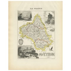
Map of Aveyron France with Rodez, Millau and Wine Routes, 19th Century
Map of Aveyron France with Rodez, Millau and Wine Routes, 19th Century
Description:
This detailed and decorative 19th-century map of Aveyron, a department in southern France, was dr...
Catégorie
Antiquités, Milieu du XIXe siècle, Français, Cartes
Matériaux
Papier