Articles similaires à Map of Côte-d'Or France with Dijon and Burgundy Wine Region, 19th Century


Vous voulez plus d'images ou de vidéos ?
Demander au vendeur plus d'images ou de vidéos
1 sur 10
Map of Côte-d'Or France with Dijon and Burgundy Wine Region, 19th Century
140 €TVA incluse
À propos de cet article
Map of Côte-d'Or France with Dijon and Burgundy Wine Region, 19th Century
Description:
This beautifully engraved 19th-century map of Côte-d'Or, located in the historic region of Burgundy, was drawn by Alexandre Vuillemin and published by Migeon in Paris as part of the *Nouvel Atlas Illustré*. Meticulously detailed and adorned with elegant vignettes, the map presents one of France’s most prestigious wine regions with geographic clarity and cultural reverence.
The map is bordered in soft pink watercolor and includes all major roads, rivers, and towns. Dijon, the department’s capital and a center of culture and gastronomy, is prominently marked, as are Beaune, Nuits-Saint-Georges, and other key communes of the Côte d’Or vineyard belt. The topography emphasizes the region’s east-facing slopes that form the heart of the wine-producing Côte de Nuits and Côte de Beaune.
In the lower left is an engraving of the city of Dijon, framed by its Gothic spires and medieval architecture. In the upper right is a portrait of a notable local figure, finely framed with ornamental detailing. The departmental coat of arms appears in the upper left, flanked by grapevines and acanthus leaves, alluding to the wine heritage of the region.
Côte-d'Or is home to some of the world’s most renowned vineyards, producing exceptional Pinot Noir and Chardonnay wines. The Côte de Nuits is celebrated for its powerful, age-worthy reds, including grand crus like Romanée-Conti and Clos de Vougeot. The Côte de Beaune is known for both outstanding reds and whites, with names such as Meursault, Puligny-Montrachet, and Corton-Charlemagne. The region’s complex terroir, centuries-old wine tradition, and strict appellation controls make it a benchmark for fine wine globally.
This map is not only a tribute to the geography of the region but also a beautiful celebration of its vinicultural and architectural achievements. It is ideal for collectors of antique maps, wine history, or French decorative prints.
Condition summary:
Very good condition with minor foxing and some light toning to the outer margins. The hand-coloring remains vibrant, and the engraving is clean and crisp.
Framing tips:
A dark mahogany or black frame pairs elegantly with the refined engraving style and pink border. A warm cream or light grey mat complements the map's historical aesthetic. Use museum-grade glass to protect the artwork and enhance visual clarity.
- Dimensions:Hauteur : 32,5 cm (12,8 po)Largeur : 26,1 cm (10,28 po)Profondeur : 0,2 mm (0,01 po)
- Matériaux et techniques:Papier,Gravé
- Lieu d'origine:
- Période:
- Date de fabrication:circa 1850
- État:Very good condition with minor foxing and some light toning to the outer margins. The hand-coloring remains vibrant, and the engraving is clean and crisp.
- Adresse du vendeur:Langweer, NL
- Numéro de référence:Vendeur : BG-13331-201stDibs : LU3054345363642
À propos du vendeur
5,0
Vendeur reconnu
Ces vendeurs prestigieux sont des leaders du secteur. Ils représentent le summum en matière de qualité et de design.
Vendeur Platine
Vendeurs premium dont la note est supérieure à 4,7 et le délai de réponse de 24 heures maximum
Établi en 2009
Vendeur 1stDibs depuis 2017
2 666 ventes sur 1stDibs
Temps de réponse habituel : <1 heure
- ExpéditionRecherche du devis...Expédition depuis : Langweer, Pays-Bas
- Politique des retours
Certaines parties de cette page ont été traduites automatiquement. 1stDibs ne garantit pas l'exactitude des traductions. L'anglais est la langue par défaut de ce site web.
Garantie d'authenticité
Bien qu'il soit peu probable que la situation se présente, dans le cas où vous rencontreriez un problème d'authenticité d'un article, contactez-nous dans un délai d'un an pour obtenir un remboursement intégral. DétailsGarantie de remboursement
Si votre article n'est pas conforme à la description, est endommagé pendant le transport ou ne vous est pas livré, contactez-nous sous 7 jours pour obtenir un remboursement intégral. DétailsAnnulation sous 24 heures
Vous disposez d'un délai de 24 heures pour annuler votre achat sans motif.Des vendeurs professionnels agréés
Nos vendeurs de renommée mondiale doivent respecter des normes strictes en matière de service et de qualité, afin de préserver l'intégrité de nos fiches produit.Garantie d'alignement des prix
Si vous constatez qu'un autre vendeur a mis en vente le même article à un prix inférieur sur un autre site, nous nous alignerons sur ce prix.Livraison en toute confiance à l'international
Notre réseau de transporteurs de premier ordre propose des options d'expédition spécialisées dans le monde entier, y compris des livraisons personnalisées.Plus d'articles de ce vendeur
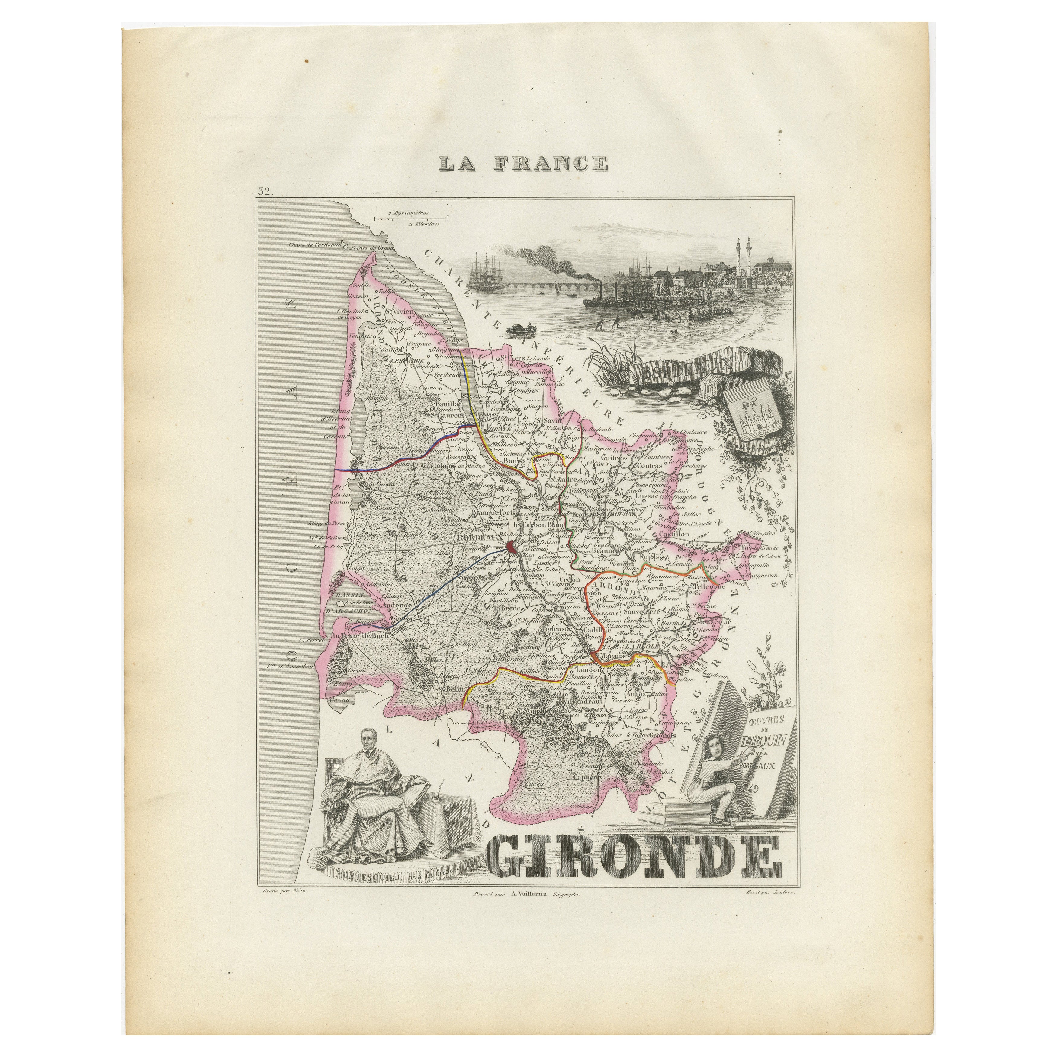
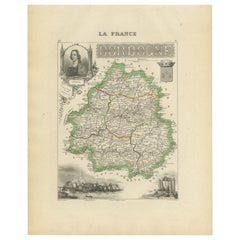
Tout afficherCarte de la Gironde en France avec la région viticole de Bordeaux par Vuillemin, C.C.
Carte de la Gironde en France avec la région viticole de Bordeaux par Vuillemin, C.C.
Cette étonnante carte de la Gironde, en France, datant du XIXe siècle, fait partie du Nouvel At...
Catégorie
Antiquités, Milieu du XIXe siècle, Français, Cartes
Matériaux
Papier
Map of Allier France with Saint-Pourçain Wine Region by Vuillemin, 19th c
Map of Allier France with Saint-Pourçain Wine Region by Vuillemin, 19th c
This decorative 19th-century map of Allier, a central department of France, comes from the celebrated Nouve...
Catégorie
Antiquités, Milieu du XIXe siècle, Français, Cartes
Matériaux
Papier

Carte du Gers en France avec A.I.C. et la région viticole de l'Armagnac par Vuillemin, 19e C.
Carte du Gers en France avec A.I.C. et la région viticole de l'Armagnac par Vuillemin, 19e C.
Cette carte gravée et coloriée à la main du département du Gers, dans le sud-ouest de l...
Catégorie
Antiquités, Milieu du XIXe siècle, Français, Cartes
Matériaux
Papier

Map of Côtes-du-Nord France with Saint-Brieuc and Brittany Coastline, c.1850
Map of Côtes-du-Nord France with Saint-Brieuc and Brittany Coastline, 19th c
Description:
This elegant 19th-century map of Côtes-du-Nord, the historic name for what is now known as ...
Catégorie
Antiquités, Milieu du XIXe siècle, Français, Cartes
Matériaux
Papier

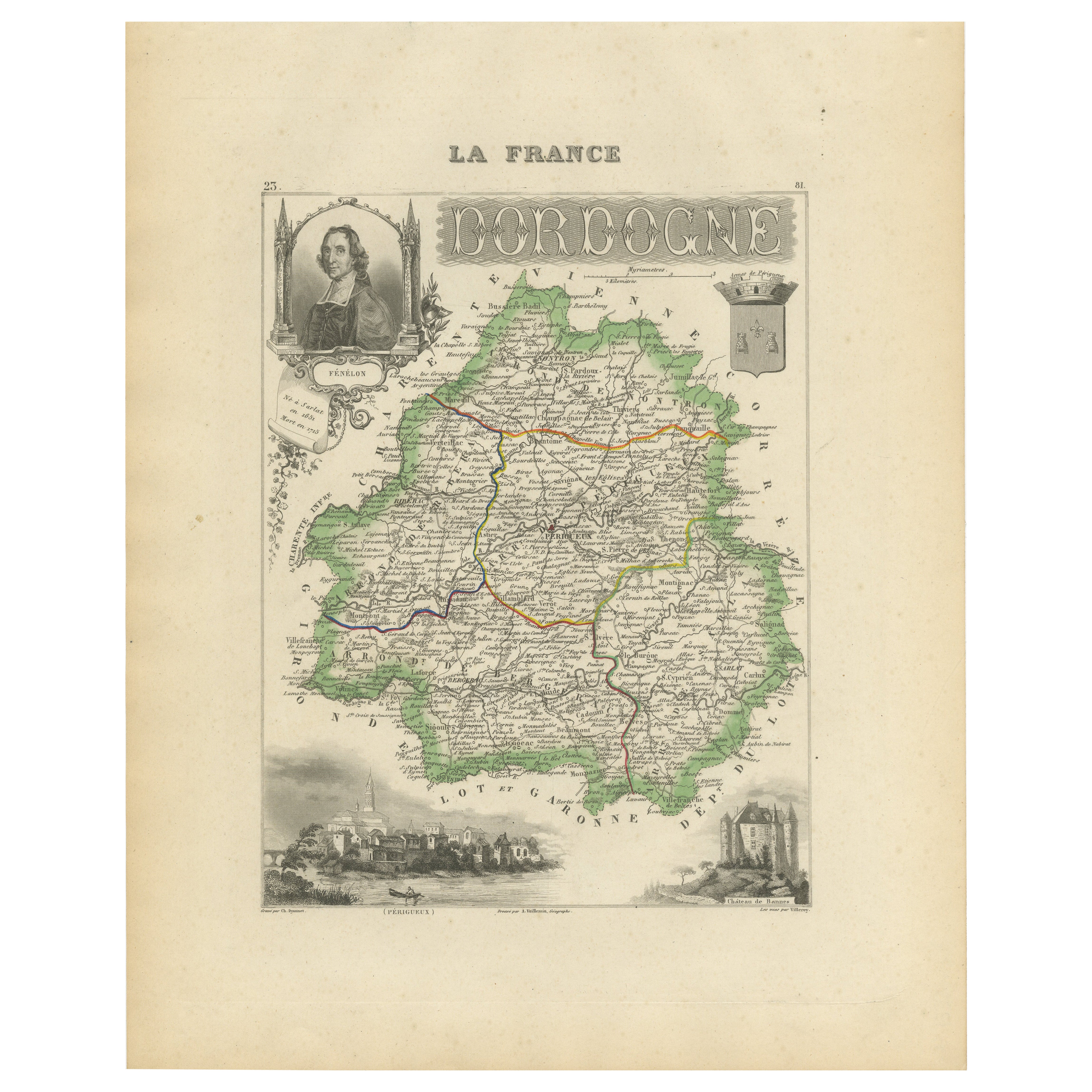
Map of Dordogne France with Périgueux and Château de Jumilhac, 19th Century
Map of Dordogne France with Périgueux and Château de Jumilhac, 19th Century
Description:
This richly detailed 19th-century map of the Dordogne department in southwestern France was ...
Catégorie
Antiquités, Milieu du XIXe siècle, Français, Cartes
Matériaux
Papier
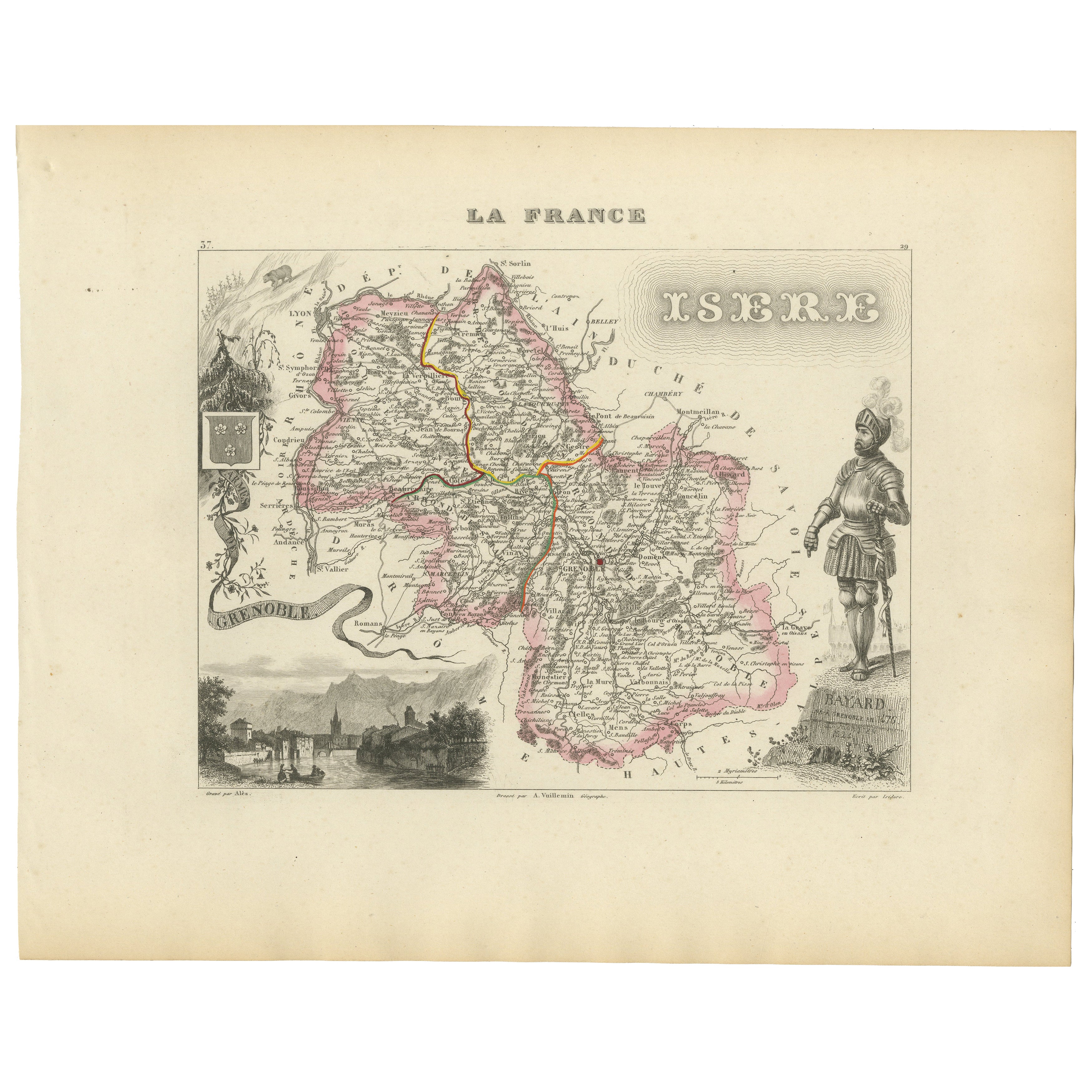
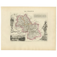
Antique French Map of Isère Region with Grenoble, Vienne, Dauphiné, 1800s
Carte ancienne de l'Isère, France par Vuillemin, 19ème siècle
Cette carte décorative du XIXe siècle présente le département de l'Isère dans le sud-est de la France, gravée par Alexa...
Catégorie
Antiquités, Milieu du XIXe siècle, Français, Cartes
Matériaux
Papier
Suggestions
Grande carte de France du 19ème siècle
Grande carte de France du 19e siècle.
Remarquable état de conservation, avec une patine d'usage agréable.
Récemment encadré.
France Circa 1874.
Catégorie
Antiquités, Fin du XIXe siècle, Français, Cartes
Matériaux
Lin, Papier

France, partie nord. Carte de l'Atlas du siècle
L'Atlas du siècle. France, partie nord".
Carte originale ancienne, 1903.
Cartes en médaillon de "La France en provinces" et de "Paris et ses environs".
Pli central tel que publié. ...
Catégorie
Début du 20ème siècle, Victorien, Plus d'Estampes
Matériaux
Lithographie

Aude, France. Carte ancienne d'un département français, 1856
Par Victor Levasseur
département de l'Aude, gravure sur acier avec contour original coloré à la main, 1856, de l'Atlas national illustré de Levasseur.
Cette région de France est célèbre pour sa grande ...
Catégorie
XIXe siècle, Naturalisme, Estampes - Paysage
Matériaux
Gravure

Aube, France. Carte ancienne d'un département français, 1856
Par Victor Levasseur
département de l'Aube, gravure sur acier avec contour original coloré à la main, 1856, de l'Atlas national illustré de Levasseur.
Cette région de France est connue pour sa producti...
Catégorie
XIXe siècle, Naturalisme, Estampes - Paysage
Matériaux
Gravure

Indre and Loire, France. Carte ancienne d'un département français, 1856
Par Victor Levasseur
département d'Indre et Loire", gravure sur acier avec contour original coloré à la main, 1856, de l'Atlas national illustré de Levasseur.
Cette région est connue pour sa production...
Catégorie
XIXe siècle, Naturalisme, Estampes - Paysage
Matériaux
Gravure

Carte Bonne de Poitou, Touraine et Anjou, France, Ric.a015, 1771
1771 Bonne carte du Poitou,
Touraine et Anjou, France
Ric.a015
1771 Carte de Potiou, Touraine et Anjou intitulée "Carte des Gouvernements D'Anjou et du Saumurois, de la Tour...
Catégorie
Antiquités, 17ème siècle, Inconnu, Cartes
Matériaux
Papier
