Articles similaires à Map of Côtes-du-Nord France with Saint-Brieuc and Brittany Coastline, c.1850


Vous voulez plus d'images ou de vidéos ?
Demander au vendeur plus d'images ou de vidéos
1 sur 10
Map of Côtes-du-Nord France with Saint-Brieuc and Brittany Coastline, c.1850
120 €TVA incluse
À propos de cet article
Map of Côtes-du-Nord France with Saint-Brieuc and Brittany Coastline, 19th c
Description:
This elegant 19th-century map of Côtes-du-Nord, the historic name for what is now known as Côtes-d’Armor in Brittany, was created by Alexandre Vuillemin and published by Migeon in Paris for the *Nouvel Atlas Illustré*. Blending precise cartographic detail with finely engraved embellishments, the map presents the coastal and inland features of this northwestern French department.
The map outlines Côtes-du-Nord in soft pink hand-coloring and carefully labels towns, rivers, and roadways. Saint-Brieuc, the prefecture, is centrally located along the northern coast, while other important towns such as Dinan, Lannion, Guingamp, and Loudéac are also marked. The geography reflects the area’s rugged coastlines, with peninsulas, small bays, and offshore islands rendered with care. The northern boundary is bordered by the English Channel, historically vital for trade and maritime activity.
A charming vignette at the top right depicts the Breton countryside with a wayside cross and a rural village in the distance—an homage to the region’s deep Catholic and pastoral traditions. In the lower right corner is a portrait of Jean-Marie de Lamennais, a prominent 19th-century priest and educational reformer from the region. The coat of arms, accompanied by a decorative banner, appears at bottom left, adding a heraldic touch.
Côtes-du-Nord, now Côtes-d’Armor, is part of historic Brittany and known for its strong cultural identity, Celtic heritage, and rich agricultural landscape. While not famous for wine, the region is renowned for apple orchards and traditional Breton cider production. It is also known for dairy, salt production, fishing, and religious architecture, including numerous chapels and calvaries.
This map captures the essence of 19th-century Brittany—spiritual, rural, and maritime—offering a decorative yet informative view of the region. It is a compelling piece for collectors of antique maps or those interested in the history and culture of northwestern France.
Condition summary:
Very good condition with slight toning to the edges and light foxing in the margins. The engraving is crisp and the hand coloring remains clear and vibrant.
Framing tips:
A rustic wood or black frame complements the coastal and cultural theme. A cream or pale grey mat will enhance the visual contrast with the soft pink border and engraved details. Use UV-protective glass for long-term preservation.
- Dimensions:Hauteur : 26,1 cm (10,28 po)Largeur : 32,5 cm (12,8 po)Profondeur : 0,2 mm (0,01 po)
- Matériaux et techniques:Papier,Gravé
- Lieu d'origine:
- Période:
- Date de fabrication:circa 1850
- État:Very good condition with slight toning to the edges and light foxing in the margins. The engraving is crisp and the hand coloring remains clear and vibrant.
- Adresse du vendeur:Langweer, NL
- Numéro de référence:Vendeur : BG-13331-211stDibs : LU3054345363662
À propos du vendeur
5,0
Vendeur reconnu
Ces vendeurs prestigieux sont des leaders du secteur. Ils représentent le summum en matière de qualité et de design.
Vendeur Platine
Vendeurs premium dont la note est supérieure à 4,7 et le délai de réponse de 24 heures maximum
Établi en 2009
Vendeur 1stDibs depuis 2017
2 641 ventes sur 1stDibs
Temps de réponse habituel : <1 heure
- ExpéditionRecherche du devis...Expédition depuis : Langweer, Pays-Bas
- Politique des retours
Certaines parties de cette page ont été traduites automatiquement. 1stDibs ne garantit pas l'exactitude des traductions. L'anglais est la langue par défaut de ce site web.
Garantie d'authenticité
Bien qu'il soit peu probable que la situation se présente, dans le cas où vous rencontreriez un problème d'authenticité d'un article, contactez-nous dans un délai d'un an pour obtenir un remboursement intégral. DétailsGarantie de remboursement
Si votre article n'est pas conforme à la description, est endommagé pendant le transport ou ne vous est pas livré, contactez-nous sous 7 jours pour obtenir un remboursement intégral. DétailsAnnulation sous 24 heures
Vous disposez d'un délai de 24 heures pour annuler votre achat sans motif.Des vendeurs professionnels agréés
Nos vendeurs de renommée mondiale doivent respecter des normes strictes en matière de service et de qualité, afin de préserver l'intégrité de nos fiches produit.Garantie d'alignement des prix
Si vous constatez qu'un autre vendeur a mis en vente le même article à un prix inférieur sur un autre site, nous nous alignerons sur ce prix.Livraison en toute confiance à l'international
Notre réseau de transporteurs de premier ordre propose des options d'expédition spécialisées dans le monde entier, y compris des livraisons personnalisées.Plus d'articles de ce vendeur
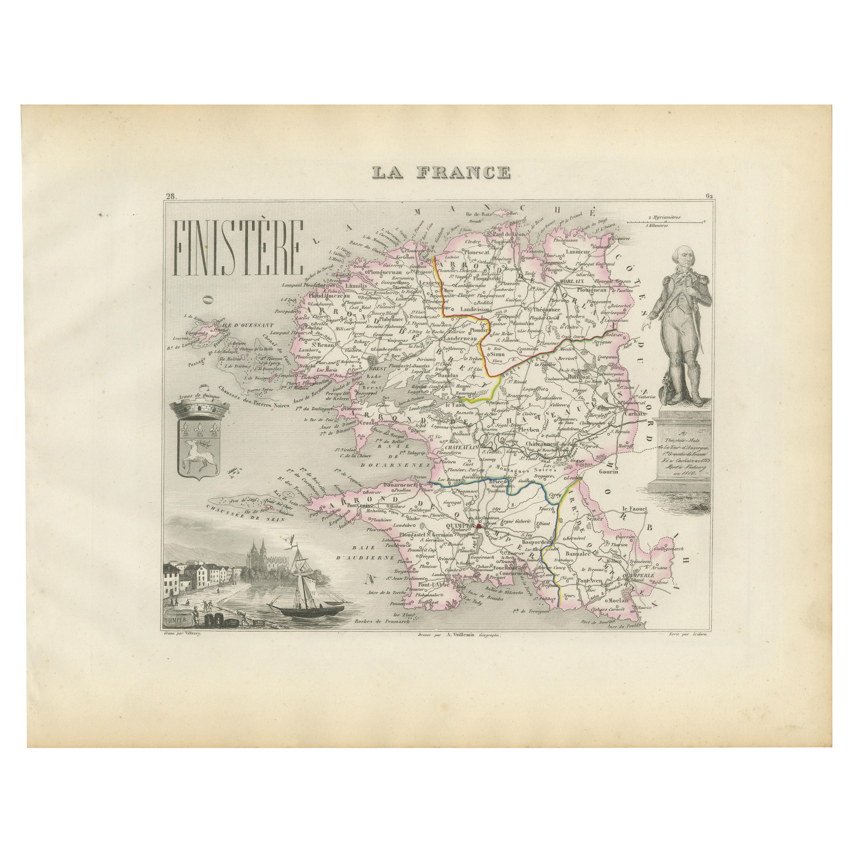
Tout afficherMap of Finistère France with Brest, Quimper and Brittany Coastline, 19th Century
Map of Finistère France with Brest, Quimper and Brittany Coastline, 19th Century
Description:
This richly engraved 19th-century map of Finistère, the westernmost department of mainl...
Catégorie
Antiquités, Milieu du XIXe siècle, Français, Cartes
Matériaux
Papier
Map of Allier France with Saint-Pourçain Wine Region by Vuillemin, 19th c
Map of Allier France with Saint-Pourçain Wine Region by Vuillemin, 19th c
This decorative 19th-century map of Allier, a central department of France, comes from the celebrated Nouve...
Catégorie
Antiquités, Milieu du XIXe siècle, Français, Cartes
Matériaux
Papier

Map of Côte-d'Or France with Dijon and Burgundy Wine Region, 19th Century
Map of Côte-d'Or France with Dijon and Burgundy Wine Region, 19th Century
Description:
This beautifully engraved 19th-century map of Côte-d'Or, located in the historic region of Bur...
Catégorie
Antiquités, Milieu du XIXe siècle, Français, Cartes
Matériaux
Papier

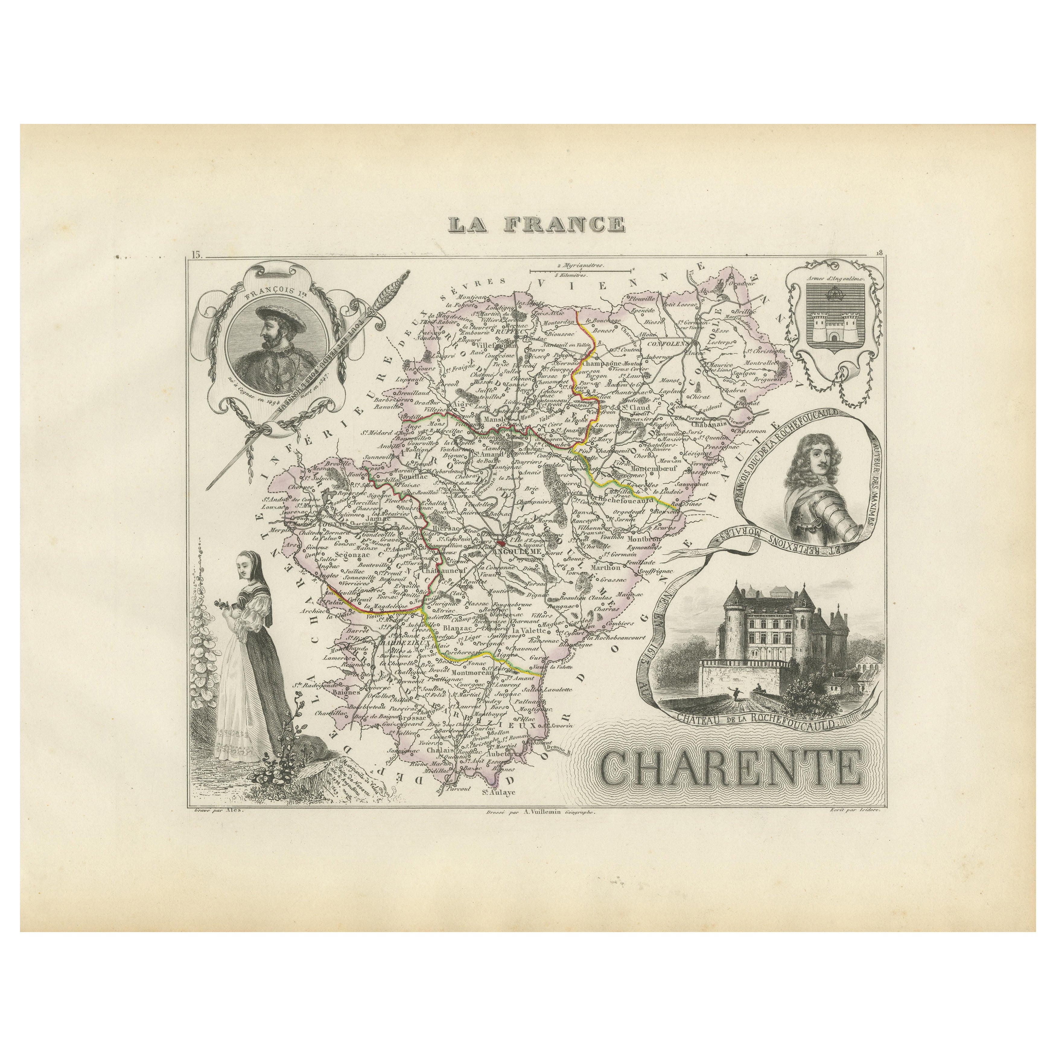
Map of Charente France with Cognac Region and Château de La Rochefoucauld, 1850
Map of Charente France with Cognac Region and Château de La Rochefoucauld, 19th c
Description:
This richly illustrated 19th-century map of the Charente department in southwestern Fr...
Catégorie
Antiquités, Milieu du XIXe siècle, Français, Cartes
Matériaux
Papier

Map of Ain France with Vineyards of Bugey and Notable Portraits, c.1850
Map of Ain France with Portraits of Bichat and Joubert by Vuillemin, 19th c
This highly decorative 19th-century map of the French department of Ain is taken from the celebrated Nouv...
Catégorie
Antiquités, Milieu du XIXe siècle, Français, Cartes
Matériaux
Papier

Map of Gard France with Pont du Gard and Wine Regions by Vuillemin, 19th c
Title: Map of Gard France with Pont du Gard and Wine Regions by Vuillemin, 19th c
Description:
This finely engraved 19th-century map of the department of Gard in southern France was...
Catégorie
Antiquités, Milieu du XIXe siècle, Français, Cartes
Matériaux
Papier

Suggestions
Indre and Loire, France. Carte ancienne d'un département français, 1856
Par Victor Levasseur
département d'Indre et Loire", gravure sur acier avec contour original coloré à la main, 1856, de l'Atlas national illustré de Levasseur.
Cette région est connue pour sa production...
Catégorie
XIXe siècle, Naturalisme, Estampes - Paysage
Matériaux
Gravure

Grande carte de France du 19ème siècle
Grande carte de France du 19e siècle.
Remarquable état de conservation, avec une patine d'usage agréable.
Récemment encadré.
France Circa 1874.
Catégorie
Antiquités, Fin du XIXe siècle, Français, Cartes
Matériaux
Lin, Papier

Lozere, France. Carte ancienne d'un département français, 1856
Par Victor Levasseur
département de la Lozère, gravure sur acier avec contour original coloré à la main, 1856, de l'Atlas national illustré de Levasseur.
Cette partie montagneuse isolée du Languedoc es...
Catégorie
XIXe siècle, Naturalisme, Estampes - Paysage
Matériaux
Gravure

Var, France. Carte ancienne d'un département français, 1856
Par Victor Levasseur
département du Var", gravure sur acier avec contour original coloré à la main, 1856, de l'Atlas National Illustre de Levasseur.
Le Var couvre le cœur de la Côte d'Azur et comprend ...
Catégorie
XIXe siècle, Naturalisme, Estampes - Paysage
Matériaux
Gravure

Saone et Loire, France. Carte ancienne d'un département français, 1856
Par Victor Levasseur
département de Saône et Loire", gravure sur acier avec contour original coloré à la main, 1856, de l'Atlas national illustré de Levasseur.
Le département français de la Saône et Lo...
Catégorie
XIXe siècle, Naturalisme, Estampes - Paysage
Matériaux
Gravure

Carte Bonne de Poitou, Touraine et Anjou, France, Ric.a015, 1771
1771 Bonne carte du Poitou,
Touraine et Anjou, France
Ric.a015
1771 Carte de Potiou, Touraine et Anjou intitulée "Carte des Gouvernements D'Anjou et du Saumurois, de la Tour...
Catégorie
Antiquités, 17ème siècle, Inconnu, Cartes
Matériaux
Papier
