Articles similaires à Map of Calvados France with Caen and Cider-Brandy Region, 19th Century


Vous voulez plus d'images ou de vidéos ?
Demander au vendeur plus d'images ou de vidéos
1 sur 10
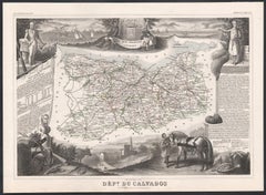
Map of Calvados France with Caen and Cider-Brandy Region, 19th Century
120 €TVA incluse
À propos de cet article
Map of Calvados France with Caen and Cider-Brandy Region, 19th Century
Description:
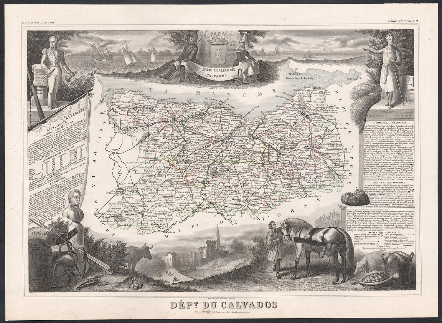
This finely engraved 19th-century map of the Calvados department in Normandy, northwestern France, comes from the *Nouvel Atlas Illustré* published in Paris by Migeon. The map was drawn by Alexandre Vuillemin and features a rich combination of precise geography and elegant embellishments, reflecting the historical and agricultural importance of this coastal region.
The map outlines Calvados in soft pink hand-coloring, highlighting towns, rivers, and roads, with the English Channel (La Manche) bordering the north. Caen, the department's capital and a cultural center since medieval times, is prominently positioned. The cartographic detailing includes the famed Norman countryside and coast, which played a vital role in French history and later in World War II.
In the lower left is a portrait of Dumont d’Urville, the explorer and naval officer born in Condé-sur-Noireau in Calvados. He is shown with nautical instruments, referencing his significant contributions to French exploration and science. In the lower right is a finely rendered view of the city of Caen, with its imposing Gothic architecture, likely representing the Church of Saint-Pierre or the Abbey of Saint-Étienne founded by William the Conqueror.
Calvados is perhaps best known for its namesake apple brandy, produced in the rolling orchards that stretch across the region. The department lies at the heart of the Calvados AOC, where cider apples are grown and distilled into one of France’s most iconic spirits. Alongside Calvados brandy, the region also produces fine cider, pommeau, and a range of cheeses, most notably Pont-l'Évêque and Livarot. These agricultural products have earned Calvados a reputation for rustic elegance and culinary depth.
This map captures the spirit of Normandy's maritime heritage, its agricultural landscape, and its intellectual legacy, making it ideal for collectors of historic French regions or food and wine enthusiasts.
Condition summary:
Very good condition with some light toning and minor foxing to the margins. The engraved detail is crisp, and the original hand coloring is well preserved.
Framing tips:
A rustic oak or walnut frame would match the map’s Norman character. A soft ivory or light grey mat will highlight the pink border color and the engraved vignette of Caen. Use museum-quality glass to protect and enhance the print for display.
- Dimensions:Hauteur : 26,1 cm (10,28 po)Largeur : 32,5 cm (12,8 po)Profondeur : 0,2 mm (0,01 po)
- Matériaux et techniques:Papier,Gravé
- Lieu d'origine:
- Période:
- Date de fabrication:circa 1850
- État:Very good condition with some light toning and minor foxing to the margins. The engraved detail is crisp, and the original hand coloring is well preserved.
- Adresse du vendeur:Langweer, NL
- Numéro de référence:Vendeur : BG-13331-131stDibs : LU3054345359802
À propos du vendeur
5,0
Vendeur reconnu
Ces vendeurs prestigieux sont des leaders du secteur. Ils représentent le summum en matière de qualité et de design.
Vendeur Platine
Vendeurs premium dont la note est supérieure à 4,7 et le délai de réponse de 24 heures maximum
Établi en 2009
Vendeur 1stDibs depuis 2017
2 589 ventes sur 1stDibs
Temps de réponse habituel : <1 heure
- ExpéditionRecherche du devis...Expédition depuis : Langweer, Pays-Bas
- Politique des retours
Certaines parties de cette page ont été traduites automatiquement. 1stDibs ne garantit pas l'exactitude des traductions. L'anglais est la langue par défaut de ce site web.
Garantie d'authenticité
Bien qu'il soit peu probable que la situation se présente, dans le cas où vous rencontreriez un problème d'authenticité d'un article, contactez-nous dans un délai d'un an pour obtenir un remboursement intégral. DétailsGarantie de remboursement
Si votre article n'est pas conforme à la description, est endommagé pendant le transport ou ne vous est pas livré, contactez-nous sous 7 jours pour obtenir un remboursement intégral. DétailsAnnulation sous 24 heures
Vous disposez d'un délai de 24 heures pour annuler votre achat sans motif.Des vendeurs professionnels agréés
Nos vendeurs de renommée mondiale doivent respecter des normes strictes en matière de service et de qualité, afin de préserver l'intégrité de nos fiches produit.Garantie d'alignement des prix
Si vous constatez qu'un autre vendeur a mis en vente le même article à un prix inférieur sur un autre site, nous nous alignerons sur ce prix.Livraison en toute confiance à l'international
Notre réseau de transporteurs de premier ordre propose des options d'expédition spécialisées dans le monde entier, y compris des livraisons personnalisées.Plus d'articles de ce vendeur
Tout afficherMap of Allier France with Saint-Pourçain Wine Region by Vuillemin, 19th c
Map of Allier France with Saint-Pourçain Wine Region by Vuillemin, 19th c
This decorative 19th-century map of Allier, a central department of France, comes from the celebrated Nouve...
Catégorie
Antiquités, Milieu du XIXe siècle, Français, Cartes
Matériaux
Papier

Map of Côtes-du-Nord France with Saint-Brieuc and Brittany Coastline, c.1850
Map of Côtes-du-Nord France with Saint-Brieuc and Brittany Coastline, 19th c
Description:
This elegant 19th-century map of Côtes-du-Nord, the historic name for what is now known as ...
Catégorie
Antiquités, Milieu du XIXe siècle, Français, Cartes
Matériaux
Papier

Map of Côte-d'Or France with Dijon and Burgundy Wine Region, 19th Century
Map of Côte-d'Or France with Dijon and Burgundy Wine Region, 19th Century
Description:
This beautifully engraved 19th-century map of Côte-d'Or, located in the historic region of Bur...
Catégorie
Antiquités, Milieu du XIXe siècle, Français, Cartes
Matériaux
Papier

Carte ancienne du Calvados 'France' par V.I.I., 1854
Par Victor Levasseur
Carte ancienne intitulée "Dépt. du Calvados". Carte du département français du Calvados, France. Cette région de France est connue pour sa production de Calvados, la meilleure eau-de...
Catégorie
Antiquités, Milieu du XIXe siècle, Cartes
Matériaux
Papier
160 € Prix de vente
20 % de remise
Map of Aude France with Carcassonne and Languedoc Vineyards, 19th Century
Map of Aude France with Carcassonne and Languedoc Vineyards, 19th Century
Description:
This elegant 19th-century map of Aude, a department in southern France along the Mediterranean...
Catégorie
Antiquités, Milieu du XIXe siècle, Français, Cartes
Matériaux
Papier

Carte ancienne du Calais « France » de V. Levasseur, 1854
Par Victor Levasseur
Carte ancienne intitulée "Dépt. du Pas de Calais". Carte du département français de Calais, France. Cette région est connue pour produire le Maroilles, un fromage à pâte molle fabriq...
Catégorie
Antiquités, Milieu du XIXe siècle, Cartes
Matériaux
Papier
144 € Prix de vente
20 % de remise
Suggestions
Calvados, France. Carte ancienne d'un département français, 1856
Par Victor Levasseur
Dept. du Calvados", gravure sur acier avec contour original coloré à la main, 1856, tirée de l'"Atlas National Illustre" de Levasseur.
Cette région de France est connue pour sa pro...
Catégorie
XIXe siècle, Naturalisme, Estampes - Paysage
Matériaux
Gravure
Grande carte de France du 19ème siècle
Grande carte de France du 19e siècle.
Remarquable état de conservation, avec une patine d'usage agréable.
Récemment encadré.
France Circa 1874.
Catégorie
Antiquités, Fin du XIXe siècle, Français, Cartes
Matériaux
Lin, Papier

Circa 1950 affiche originale de la carte du Calvados, designée par André Lesot - Normandie
Cette affiche cartographique originale du CIRCA datant de 1950, conçue par André Lesot, est une représentation magnifiquement détaillée de cette région historique de Normandie, en Fr...
Catégorie
années 1950, Estampes et éditions
Matériaux
Lithographie, Papier, Lin
Aude, France. Carte ancienne d'un département français, 1856
Par Victor Levasseur
département de l'Aude, gravure sur acier avec contour original coloré à la main, 1856, de l'Atlas national illustré de Levasseur.
Cette région de France est célèbre pour sa grande ...
Catégorie
XIXe siècle, Naturalisme, Estampes - Paysage
Matériaux
Gravure

Var, France. Carte ancienne d'un département français, 1856
Par Victor Levasseur
département du Var", gravure sur acier avec contour original coloré à la main, 1856, de l'Atlas National Illustre de Levasseur.
Le Var couvre le cœur de la Côte d'Azur et comprend ...
Catégorie
XIXe siècle, Naturalisme, Estampes - Paysage
Matériaux
Gravure

France, partie nord. Carte de l'Atlas du siècle
L'Atlas du siècle. France, partie nord".
Carte originale ancienne, 1903.
Cartes en médaillon de "La France en provinces" et de "Paris et ses environs".
Pli central tel que publié. ...
Catégorie
Début du 20ème siècle, Victorien, Plus d'Estampes
Matériaux
Lithographie
