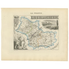
Articles similaires à Map of Cher France with Bourges, Sancerre Vineyards and Engraved Vignettes, 1850


Vous voulez plus d'images ou de vidéos ?
Demander au vendeur plus d'images ou de vidéos
1 sur 10
Map of Cher France with Bourges, Sancerre Vineyards and Engraved Vignettes, 1850
120 €TVA incluse
À propos de cet article
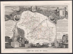
Map of Charente-Inférieure France with La Rochelle and Coastal Vineyards, 19th c
Description:
This decorative 19th-century map of the former department of Charente-Inférieure, now known as Charente-Maritime, was published in Paris by Migeon as part of the *Nouvel Atlas Illustré* and drawn by Alexandre Vuillemin. The map combines precise geographic rendering with visual storytelling, capturing the essence of France’s Atlantic coast during the mid-1800s.
Hand-colored in soft pink along the departmental borders, the map includes all major towns and transport routes, with La Rochelle and Rochefort prominently featured. The Atlantic coastline, river systems, and offshore islands such as Île de Ré and Île d’Oléron are clearly indicated. These elements emphasize the maritime identity of the region, historically shaped by naval, commercial, and fishing activity.
In the lower portion of the sheet is an engraved view of the fortified port city of La Rochelle, its harbor marked by towers and stone quays. At the top right, dockworkers are shown with a large anchor and chains, illustrating Rochefort’s role as an important naval base and shipyard during the Ancien Régime and Napoleonic era. On the right side is a portrait of de Ratzau, likely referring to the marquis who played a role in 17th-century military affairs in the region.
Charente-Maritime is also known for its viticulture, particularly its contribution to the Cognac region. Vineyards near Saintes and Jonzac form part of the outer areas of Cognac production. Additionally, the region is famous for its Pineau des Charentes, a sweet fortified wine blending grape must and Cognac. These coastal vineyards thrive in a maritime climate, producing grapes with distinctive character.
Beyond wine, the region is also celebrated for salt marshes, oysters from Marennes-Oléron, and a strong seafaring heritage. This map is an elegant tribute to a historically rich region whose legacy blends land, sea, and cultural depth.
Condition summary:
Very good antique condition. Light age toning and minor scattered foxing, mostly near the margins. Engraved lines are clear and the original hand coloring is well preserved.
Framing tips:
Pair this map with a light wood or brushed silver frame to echo the maritime setting. Use a pale blue or cream mat to complement the coastal theme and pastel borders. UV-protective glass is recommended for display and preservation.
- Dimensions:Hauteur : 32,5 cm (12,8 po)Largeur : 26,1 cm (10,28 po)Profondeur : 0,2 mm (0,01 po)
- Matériaux et techniques:Papier,Gravé
- Lieu d'origine:
- Période:
- Date de fabrication:circa 1850
- État:Very good antique condition. Light age toning and minor scattered foxing, mostly near the margins. Engraved lines are clear and the original hand coloring is well preserved.
- Adresse du vendeur:Langweer, NL
- Numéro de référence:Vendeur : BG-13331-171stDibs : LU3054345363582
À propos du vendeur
5,0
Vendeur reconnu
Ces vendeurs prestigieux sont des leaders du secteur. Ils représentent le summum en matière de qualité et de design.
Vendeur Platine
Vendeurs premium dont la note est supérieure à 4,7 et le délai de réponse de 24 heures maximum
Établi en 2009
Vendeur 1stDibs depuis 2017
2 662 ventes sur 1stDibs
Temps de réponse habituel : <1 heure
- ExpéditionRecherche du devis...Expédition depuis : Langweer, Pays-Bas
- Politique des retours
Certaines parties de cette page ont été traduites automatiquement. 1stDibs ne garantit pas l'exactitude des traductions. L'anglais est la langue par défaut de ce site web.
Garantie d'authenticité
Bien qu'il soit peu probable que la situation se présente, dans le cas où vous rencontreriez un problème d'authenticité d'un article, contactez-nous dans un délai d'un an pour obtenir un remboursement intégral. DétailsGarantie de remboursement
Si votre article n'est pas conforme à la description, est endommagé pendant le transport ou ne vous est pas livré, contactez-nous sous 7 jours pour obtenir un remboursement intégral. DétailsAnnulation sous 24 heures
Vous disposez d'un délai de 24 heures pour annuler votre achat sans motif.Des vendeurs professionnels agréés
Nos vendeurs de renommée mondiale doivent respecter des normes strictes en matière de service et de qualité, afin de préserver l'intégrité de nos fiches produit.Garantie d'alignement des prix
Si vous constatez qu'un autre vendeur a mis en vente le même article à un prix inférieur sur un autre site, nous nous alignerons sur ce prix.Livraison en toute confiance à l'international
Notre réseau de transporteurs de premier ordre propose des options d'expédition spécialisées dans le monde entier, y compris des livraisons personnalisées.Plus d'articles de ce vendeur
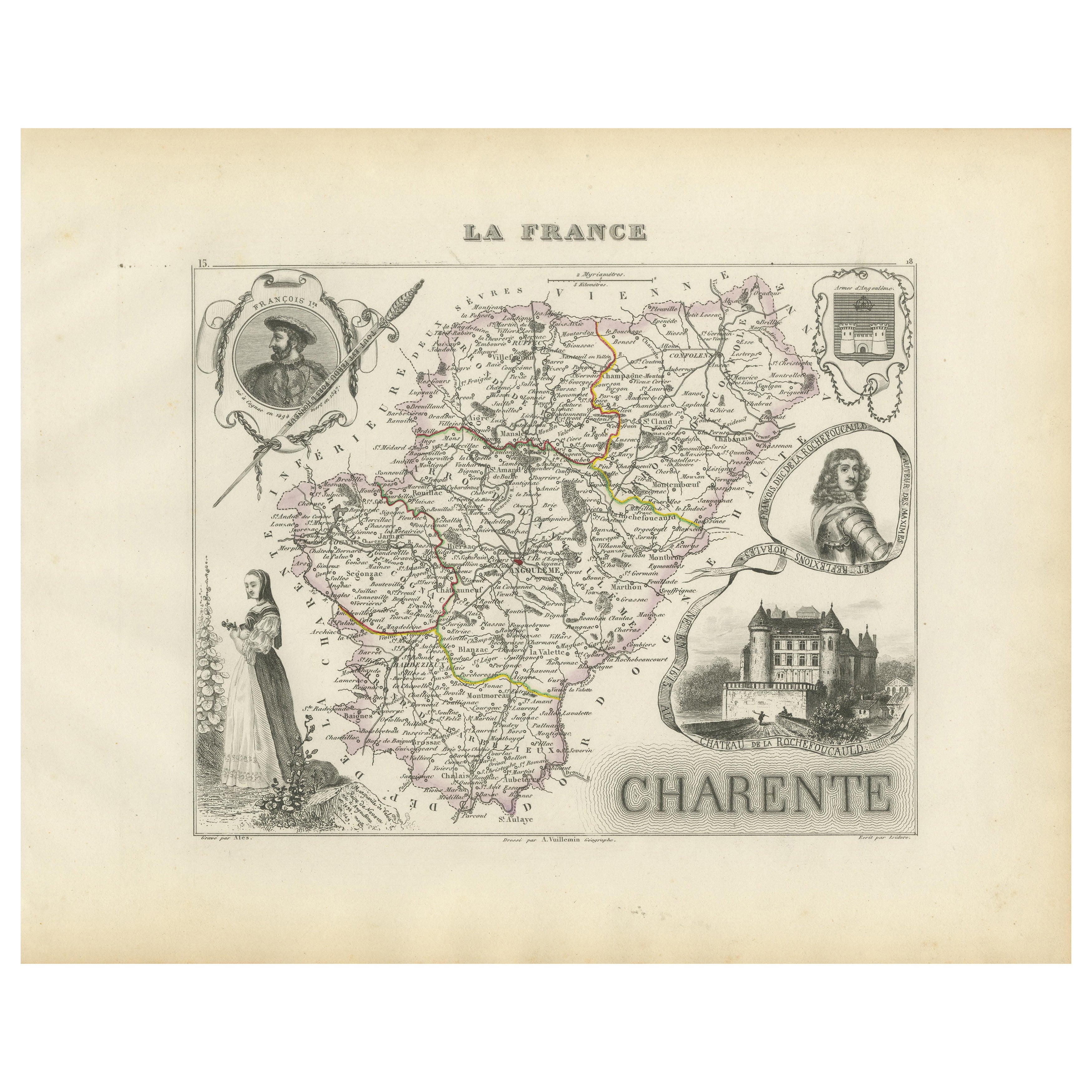
Tout afficherMap of Charente France with Cognac Region and Château de La Rochefoucauld, 1850
Map of Charente France with Cognac Region and Château de La Rochefoucauld, 19th c
Description:
This richly illustrated 19th-century map of the Charente department in southwestern Fr...
Catégorie
Antiquités, Milieu du XIXe siècle, Français, Cartes
Matériaux
Papier

Carte du Gers en France avec A.I.C. et la région viticole de l'Armagnac par Vuillemin, 19e C.
Carte du Gers en France avec A.I.C. et la région viticole de l'Armagnac par Vuillemin, 19e C.
Cette carte gravée et coloriée à la main du département du Gers, dans le sud-ouest de l...
Catégorie
Antiquités, Milieu du XIXe siècle, Français, Cartes
Matériaux
Papier

Map of Côtes-du-Nord France with Saint-Brieuc and Brittany Coastline, c.1850
Map of Côtes-du-Nord France with Saint-Brieuc and Brittany Coastline, 19th c
Description:
This elegant 19th-century map of Côtes-du-Nord, the historic name for what is now known as ...
Catégorie
Antiquités, Milieu du XIXe siècle, Français, Cartes
Matériaux
Papier

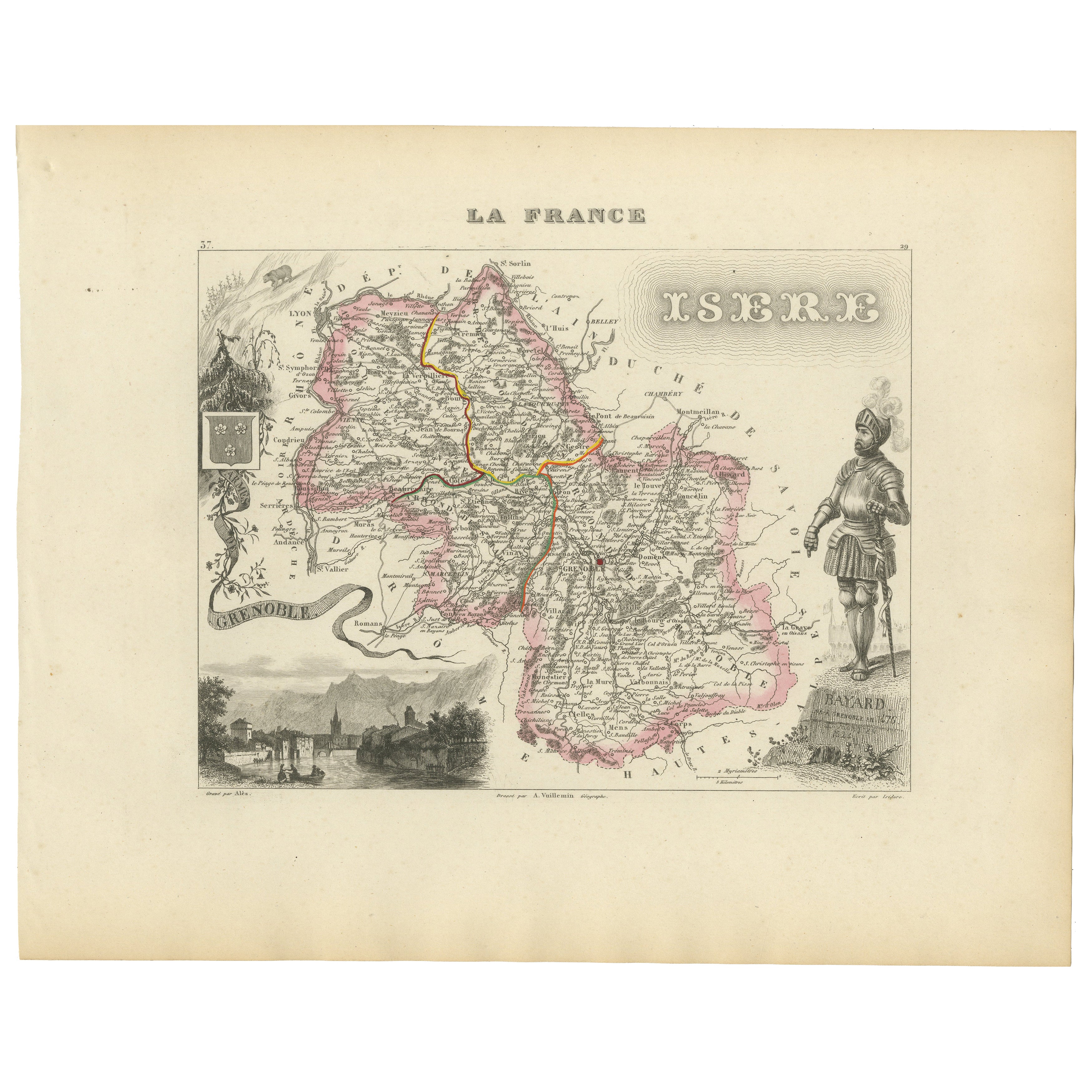
Antique French Map of Isère Region with Grenoble, Vienne, Dauphiné, 1800s
Carte ancienne de l'Isère, France par Vuillemin, 19ème siècle
Cette carte décorative du XIXe siècle présente le département de l'Isère dans le sud-est de la France, gravée par Alexa...
Catégorie
Antiquités, Milieu du XIXe siècle, Français, Cartes
Matériaux
Papier
Map of Allier France with Saint-Pourçain Wine Region by Vuillemin, 19th c
Map of Allier France with Saint-Pourçain Wine Region by Vuillemin, 19th c
This decorative 19th-century map of Allier, a central department of France, comes from the celebrated Nouve...
Catégorie
Antiquités, Milieu du XIXe siècle, Français, Cartes
Matériaux
Papier

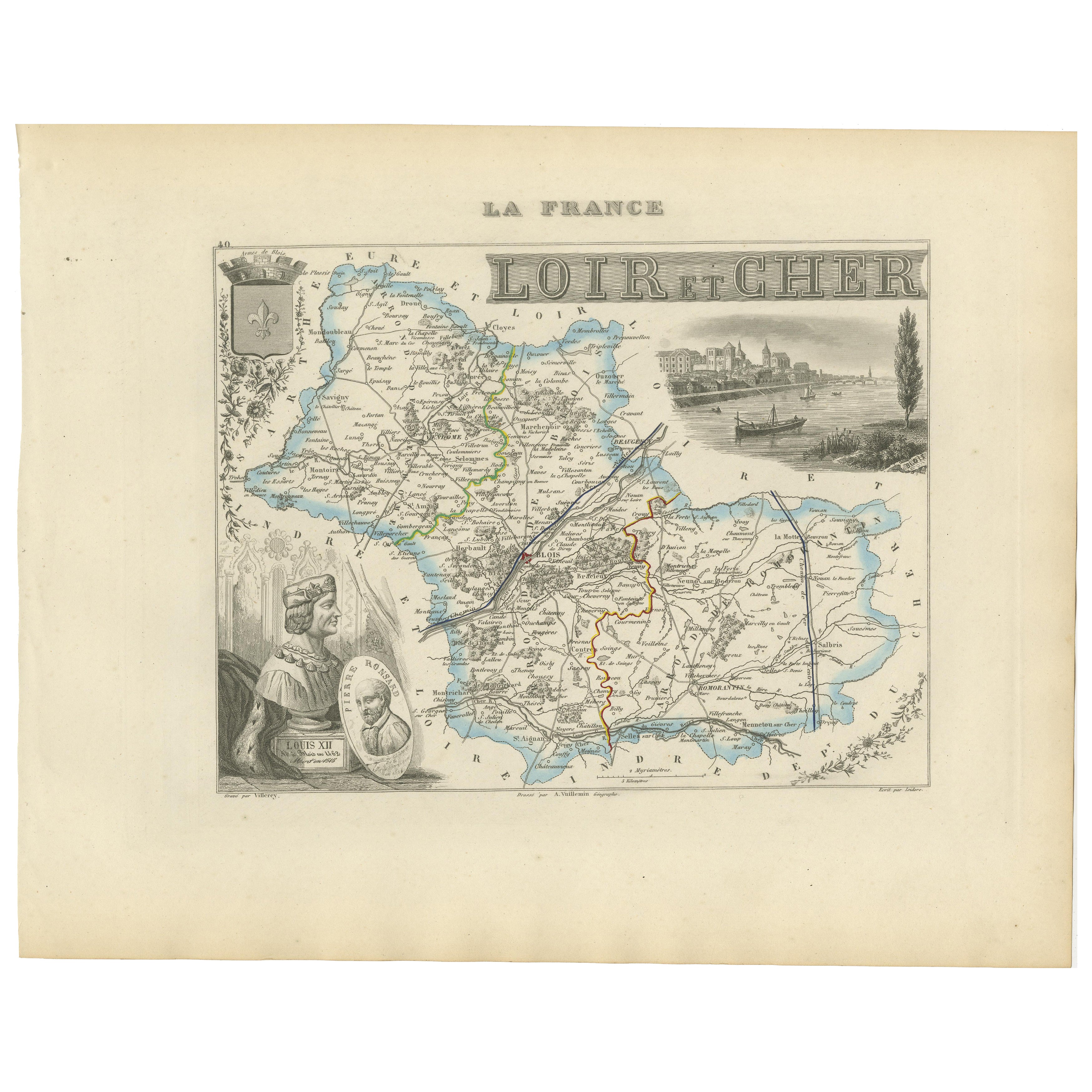
Carte du Loir-et-Cher, France, 19ème siècle - Blois, Vendôme, Châteaux de la Loire
Carte ancienne du Loir-et-Cher, France par Vuillemin, 19ème siècle
Belle carte gravée du département du Loir-et-Cher datant du XIXe siècle, dessinée et gravée par Alexandre Vuillemi...
Catégorie
Antiquités, Milieu du XIXe siècle, Français, Cartes
Matériaux
Papier
Suggestions
Loir et Cher, France. Carte ancienne d'un département français, 1856
Par Victor Levasseur
département du Loir et du Cher", gravure sur acier avec contour original coloré à la main, 1856, de l'Atlas national illustré de Levasseur.
Cette région est principalement connue p...
Catégorie
XIXe siècle, Naturalisme, Estampes - Paysage
Matériaux
Gravure
Aube, France. Carte ancienne d'un département français, 1856
Par Victor Levasseur
département de l'Aube, gravure sur acier avec contour original coloré à la main, 1856, de l'Atlas national illustré de Levasseur.
Cette région de France est connue pour sa producti...
Catégorie
XIXe siècle, Naturalisme, Estampes - Paysage
Matériaux
Gravure

L'Isere, France. Carte ancienne du département français de l'antiquité, 1856
Par Victor Levasseur
département de l'Isère, gravure sur acier avec contour original coloré à la main, 1856, de l'Atlas national illustré de Levasseur.
Cette région est connue pour sa production de Ble...
Catégorie
XIXe siècle, Naturalisme, Estampes - Paysage
Matériaux
Gravure

Indre and Loire, France. Carte ancienne d'un département français, 1856
Par Victor Levasseur
département d'Indre et Loire", gravure sur acier avec contour original coloré à la main, 1856, de l'Atlas national illustré de Levasseur.
Cette région est connue pour sa production...
Catégorie
XIXe siècle, Naturalisme, Estampes - Paysage
Matériaux
Gravure

Lozere, France. Carte ancienne d'un département français, 1856
Par Victor Levasseur
département de la Lozère, gravure sur acier avec contour original coloré à la main, 1856, de l'Atlas national illustré de Levasseur.
Cette partie montagneuse isolée du Languedoc es...
Catégorie
XIXe siècle, Naturalisme, Estampes - Paysage
Matériaux
Gravure

Aude, France. Carte ancienne d'un département français, 1856
Par Victor Levasseur
département de l'Aude, gravure sur acier avec contour original coloré à la main, 1856, de l'Atlas national illustré de Levasseur.
Cette région de France est célèbre pour sa grande ...
Catégorie
XIXe siècle, Naturalisme, Estampes - Paysage
Matériaux
Gravure
