Articles similaires à Map of Drôme France with Valence and Rhône Valley Wine Region, 19th Century


Vous voulez plus d'images ou de vidéos ?
Demander au vendeur plus d'images ou de vidéos
1 sur 10
Map of Drôme France with Valence and Rhône Valley Wine Region, 19th Century
140 €TVA incluse
À propos de cet article
Map of Drôme France with Valence and Rhône Valley Wine Region, 19th Century
Description:
This beautifully engraved 19th-century map of the Drôme department in southeastern France was created by Alexandre Vuillemin and published by Migeon in Paris as part of the *Nouvel Atlas Illustré*. Combining precise geography with classical decoration, this map offers a detailed portrait of a region that bridges the Alpine foothills and the fertile Rhône Valley.
Outlined in soft hand-colored pink, the map includes towns, roads, rivers, and administrative borders. Valence, the departmental capital and a historic gateway to the south of France, is prominently placed near the top. Other notable towns such as Montélimar, Die, and Nyons are labeled with clarity, and the layout captures the topographical transition from mountainous terrain in the east to the flatter Rhône corridor in the west.
At the top right, a vignette of Valence shows the town nestled beneath the Vercors mountains. Below that is a portrait of the French dramatist Pierre-Antoine de Chamfort, who was born in Clermont-Ferrand but had associations with the intellectual life of the region. Additional engravings include a suspension bridge over the Rhône River and an image of a goat, likely referencing the local production of regional cheeses and pastoral traditions.
Drôme lies in the heart of the Côtes du Rhône wine region, particularly its southern section. The department is home to some well-regarded appellations including Crozes-Hermitage, Hermitage, and Clairette de Die. These wines—made from Syrah, Marsanne, Roussanne, and Muscat, among other grapes—are known for their rich textures, spice, and balance. In addition to viticulture, the region is also recognized for truffle production, olive oil, nougat from Montélimar, and lavender fields in the southern zones.
This antique map is a fitting tribute to Drôme’s blend of agricultural richness, cultural history, and natural beauty. It is a wonderful addition to any collection of wine-related maps, regional French art, or decorative cartography.
Condition summary:
Very good condition with slight age toning and a few minor foxing marks along the margins. The engraved lines are sharp and the original hand coloring remains vibrant.
Framing tips:
A walnut or dark oak frame will complement the regional warmth of the Drôme landscape. Use a light cream or muted lavender mat to match the coloring and draw out the engraved vignettes. UV-protective glass is recommended for preservation and clarity.
- Dimensions:Hauteur : 26,1 cm (10,28 po)Largeur : 32,5 cm (12,8 po)Profondeur : 0,2 mm (0,01 po)
- Matériaux et techniques:Papier,Gravé
- Lieu d'origine:
- Période:
- Date de fabrication:circa 1850
- État:Very good condition with slight age toning and a few minor foxing marks along the margins. The engraved lines are sharp and the original hand coloring remains vibrant.
- Adresse du vendeur:Langweer, NL
- Numéro de référence:Vendeur : BG-13331-251stDibs : LU3054345363872
À propos du vendeur
5,0
Vendeur reconnu
Ces vendeurs prestigieux sont des leaders du secteur. Ils représentent le summum en matière de qualité et de design.
Vendeur Platine
Vendeurs premium dont la note est supérieure à 4,7 et le délai de réponse de 24 heures maximum
Établi en 2009
Vendeur 1stDibs depuis 2017
2 641 ventes sur 1stDibs
Temps de réponse habituel : <1 heure
- ExpéditionRecherche du devis...Expédition depuis : Langweer, Pays-Bas
- Politique des retours
Certaines parties de cette page ont été traduites automatiquement. 1stDibs ne garantit pas l'exactitude des traductions. L'anglais est la langue par défaut de ce site web.
Garantie d'authenticité
Bien qu'il soit peu probable que la situation se présente, dans le cas où vous rencontreriez un problème d'authenticité d'un article, contactez-nous dans un délai d'un an pour obtenir un remboursement intégral. DétailsGarantie de remboursement
Si votre article n'est pas conforme à la description, est endommagé pendant le transport ou ne vous est pas livré, contactez-nous sous 7 jours pour obtenir un remboursement intégral. DétailsAnnulation sous 24 heures
Vous disposez d'un délai de 24 heures pour annuler votre achat sans motif.Des vendeurs professionnels agréés
Nos vendeurs de renommée mondiale doivent respecter des normes strictes en matière de service et de qualité, afin de préserver l'intégrité de nos fiches produit.Garantie d'alignement des prix
Si vous constatez qu'un autre vendeur a mis en vente le même article à un prix inférieur sur un autre site, nous nous alignerons sur ce prix.Livraison en toute confiance à l'international
Notre réseau de transporteurs de premier ordre propose des options d'expédition spécialisées dans le monde entier, y compris des livraisons personnalisées.Plus d'articles de ce vendeur
Tout afficherMap of Allier France with Saint-Pourçain Wine Region by Vuillemin, 19th c
Map of Allier France with Saint-Pourçain Wine Region by Vuillemin, 19th c
This decorative 19th-century map of Allier, a central department of France, comes from the celebrated Nouve...
Catégorie
Antiquités, Milieu du XIXe siècle, Français, Cartes
Matériaux
Papier

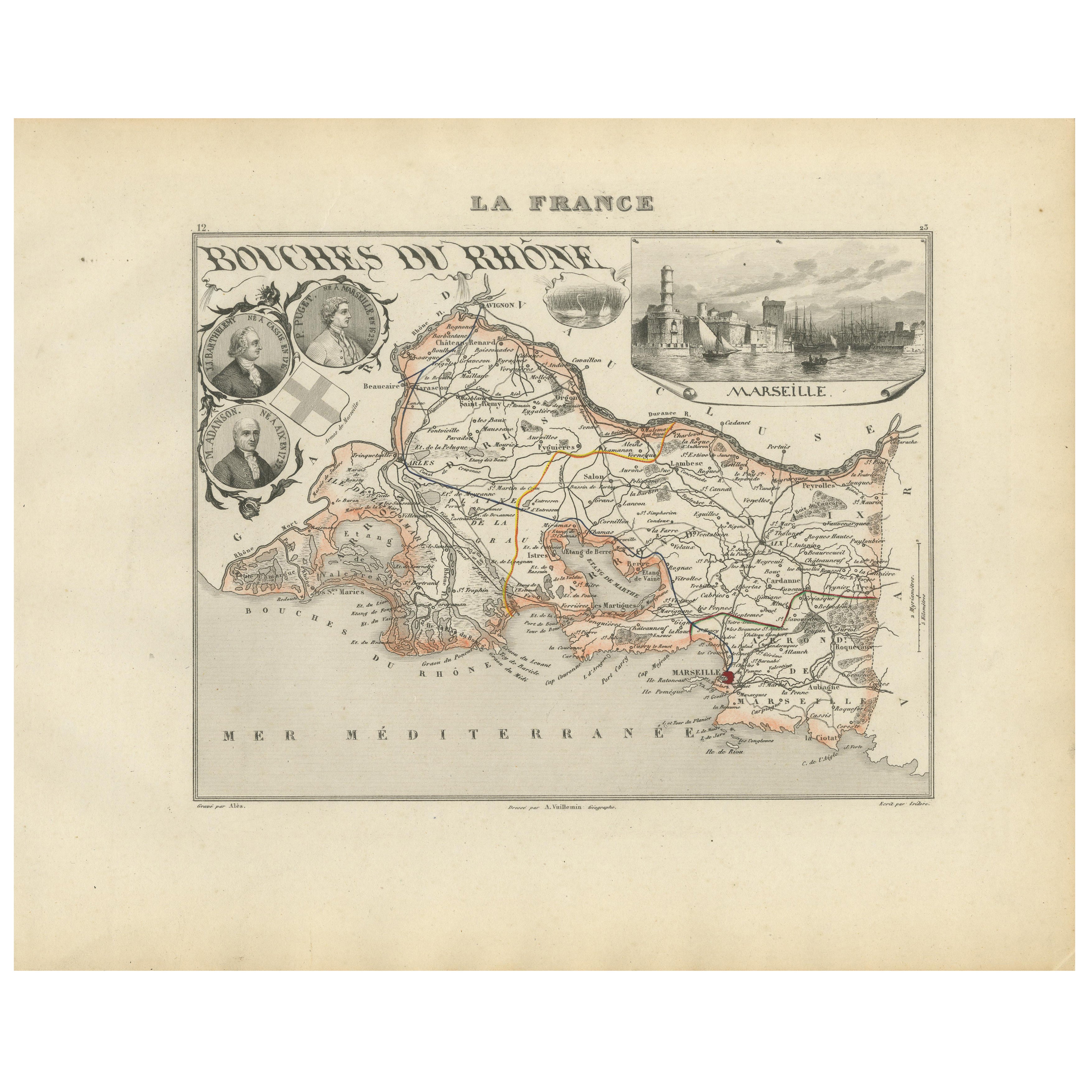
Map of Bouches-du-Rhône France with Marseille and Rhône Delta, 19th Century
Map of Bouches-du-Rhône France with Marseille and Rhône Delta, 19th Century
Description:
This finely engraved 19th-century map of the Bouches-du-Rhône department in southeastern Fra...
Catégorie
Antiquités, Milieu du XIXe siècle, Français, Cartes
Matériaux
Papier
Map of Côtes-du-Nord France with Saint-Brieuc and Brittany Coastline, c.1850
Map of Côtes-du-Nord France with Saint-Brieuc and Brittany Coastline, 19th c
Description:
This elegant 19th-century map of Côtes-du-Nord, the historic name for what is now known as ...
Catégorie
Antiquités, Milieu du XIXe siècle, Français, Cartes
Matériaux
Papier

Map of Côte-d'Or France with Dijon and Burgundy Wine Region, 19th Century
Map of Côte-d'Or France with Dijon and Burgundy Wine Region, 19th Century
Description:
This beautifully engraved 19th-century map of Côte-d'Or, located in the historic region of Bur...
Catégorie
Antiquités, Milieu du XIXe siècle, Français, Cartes
Matériaux
Papier

Map of Aisne France with Soissons and Champagne Vineyards by Vuillemin, 19th c
Map of Aisne France with Soissons and Champagne Vineyards by Vuillemin, 19th c
Description:
This richly detailed 19th-century engraved and hand-colored map of the department of Aisn...
Catégorie
Antiquités, Milieu du XIXe siècle, Français, Cartes
Matériaux
Papier

Map of Aude France with Carcassonne and Languedoc Vineyards, 19th Century
Map of Aude France with Carcassonne and Languedoc Vineyards, 19th Century
Description:
This elegant 19th-century map of Aude, a department in southern France along the Mediterranean...
Catégorie
Antiquités, Milieu du XIXe siècle, Français, Cartes
Matériaux
Papier

Suggestions
Grande carte de France du 19ème siècle
Grande carte de France du 19e siècle.
Remarquable état de conservation, avec une patine d'usage agréable.
Récemment encadré.
France Circa 1874.
Catégorie
Antiquités, Fin du XIXe siècle, Français, Cartes
Matériaux
Lin, Papier

Carte de la Haute Vienne - Lithographie originale - 19ème siècle
Carte de la Haute Vienne est une œuvre d'art originale en lithographie réalisée par une Graveur anonyme du 19ème siècle.
Imprimé dans la série des "France Pittoresque".
Intitulé ...
Catégorie
XIXe siècle, Moderne, Estampes - Figuratif
Matériaux
Lithographie

L'Isere, France. Carte ancienne du département français de l'antiquité, 1856
Par Victor Levasseur
département de l'Isère, gravure sur acier avec contour original coloré à la main, 1856, de l'Atlas national illustré de Levasseur.
Cette région est connue pour sa production de Ble...
Catégorie
XIXe siècle, Naturalisme, Estampes - Paysage
Matériaux
Gravure

France, partie nord. Carte de l'Atlas du siècle
L'Atlas du siècle. France, partie nord".
Carte originale ancienne, 1903.
Cartes en médaillon de "La France en provinces" et de "Paris et ses environs".
Pli central tel que publié. ...
Catégorie
Début du 20ème siècle, Victorien, Plus d'Estampes
Matériaux
Lithographie

Carte de Rhne - Gravure originale - 19ème siècle
Carte du Rhône est une gravure originale ancienne réalisée par un graveur anonyme du 19ème siècle.
Imprimé en série de "France Pittoresque" en haut au centre.
L'état de conservatio...
Catégorie
XIXe siècle, Moderne, Estampes - Figuratif
Matériaux
Eau-forte

Aude, France. Carte ancienne d'un département français, 1856
Par Victor Levasseur
département de l'Aude, gravure sur acier avec contour original coloré à la main, 1856, de l'Atlas national illustré de Levasseur.
Cette région de France est célèbre pour sa grande ...
Catégorie
XIXe siècle, Naturalisme, Estampes - Paysage
Matériaux
Gravure
