Articles similaires à Map of Gard France with Pont du Gard and Wine Regions by Vuillemin, 19th c


Vous voulez plus d'images ou de vidéos ?
Demander au vendeur plus d'images ou de vidéos
1 sur 10
Map of Gard France with Pont du Gard and Wine Regions by Vuillemin, 19th c
140 €TVA incluse
À propos de cet article
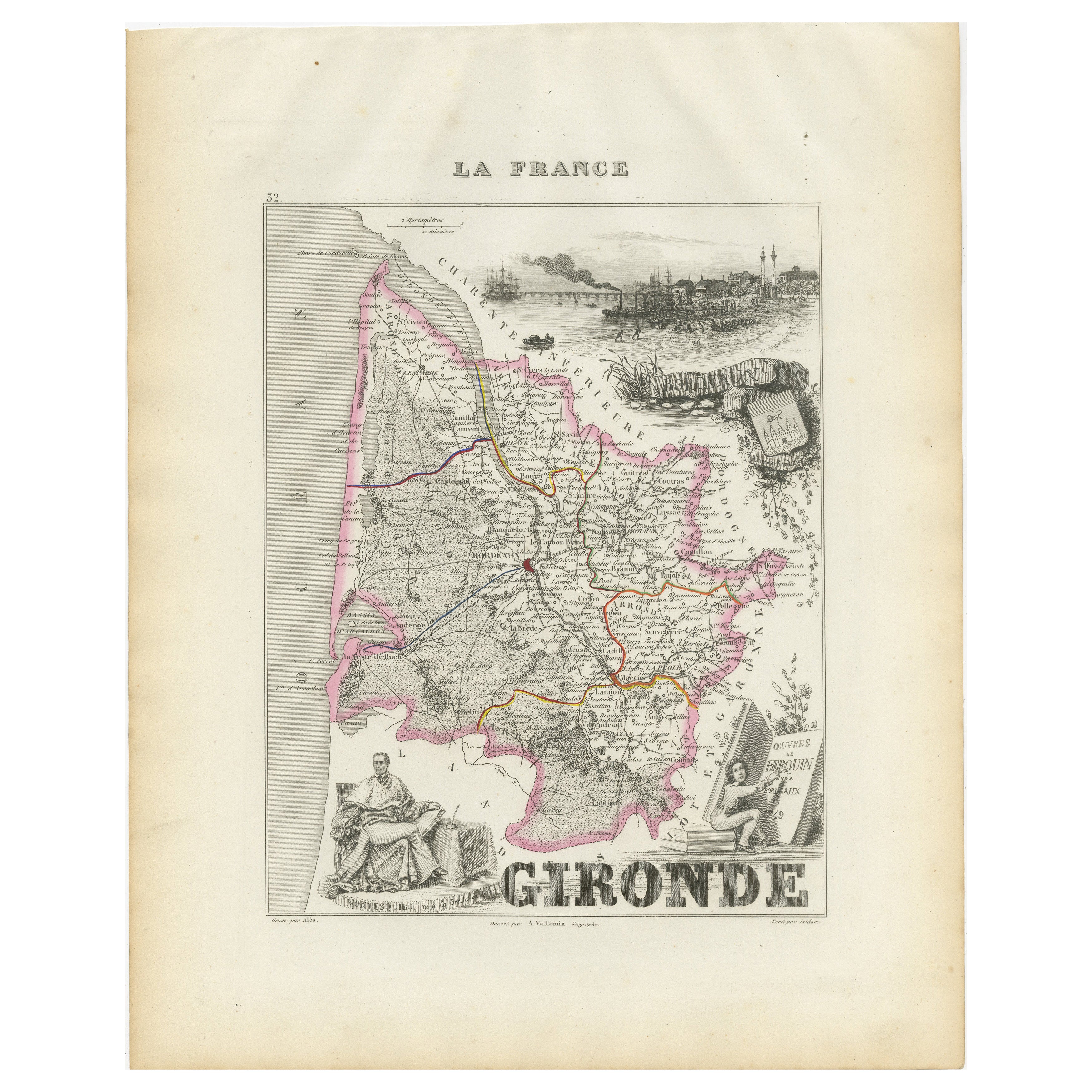
Title: Map of Gard France with Pont du Gard and Wine Regions by Vuillemin, 19th c
Description:
This finely engraved 19th-century map of the department of Gard in southern France was produced by Alexandre Vuillemin and published by Migeon in Paris as part of the *Nouvel Atlas Illustré*. The map blends detailed topographical information with artistic embellishments, offering a window into the geography, culture, and heritage of the region.
Gard is located in the Occitanie region and borders the Mediterranean Sea, Ardèche, Hérault, Bouches-du-Rhône, and Lozère. The map outlines the department with a fine hand-colored orange border and clearly marks towns, rivers, roadways, and topographic features. Nîmes, Uzès, Alès, and Beaucaire are among the many towns shown in detail.
At the lower left, a beautifully rendered vignette features the iconic **Pont du Gard**, a Roman aqueduct that stands as one of the most impressive and well-preserved Roman engineering feats in France. Built in the first century AD, it carried water to the city of Nîmes and remains a UNESCO World Heritage Site.
To the lower right, the map includes a portrait of **Jacques-Joseph de Gourbillon**, a local historical figure, with an unfurled map scroll and inscription. A coat of arms and botanical ornamentation add further decorative elements to the sheet.
Gard is also well known for its wine production, forming part of the greater **Côtes du Rhône** appellation. Vineyards near the Rhône River, including those around Tavel and Lirac, are especially notable. Tavel produces one of France’s most celebrated rosé wines, known for its full body, dry character, and historical reputation—it was said to be a favorite of Louis XIV and Ernest Hemingway. The department also produces reds and whites under the Costières de Nîmes and Duché d’Uzès AOCs, showcasing a blend of Mediterranean climate and Rhône varietals such as Syrah, Grenache, Mourvèdre, and Viognier.
Alexandre Vuillemin, a highly regarded French cartographer of the 19th century, was known for his clear yet decorative maps. His works with Migeon often included informative and picturesque features that made geography accessible and engaging to a broader audience.
Condition summary:
Very good condition with light age toning at the edges and a few minor foxing marks. The engraved detail remains sharp and the hand coloring is clean and well-preserved.
Framing tips:
Frame this map in a natural walnut or classic gold frame to enhance the historic charm. A warm ivory or pale terracotta mat will complement the orange border and Mediterranean tone of the subject. UV-protective glass is recommended for conservation.
- Dimensions:Hauteur : 26,1 cm (10,28 po)Largeur : 32,5 cm (12,8 po)Profondeur : 0,2 mm (0,01 po)
- Matériaux et techniques:Papier,Gravé
- Lieu d'origine:
- Période:
- Date de fabrication:circa 1850
- État:Very good condition with light age toning at the edges and a few minor foxing marks. The engraved detail remains sharp and the hand coloring is clean and well-preserved.
- Adresse du vendeur:Langweer, NL
- Numéro de référence:Vendeur : BG-13331-291stDibs : LU3054345363922
À propos du vendeur
5,0
Vendeur reconnu
Ces vendeurs prestigieux sont des leaders du secteur. Ils représentent le summum en matière de qualité et de design.
Vendeur Platine
Vendeurs premium dont la note est supérieure à 4,7 et le délai de réponse de 24 heures maximum
Établi en 2009
Vendeur 1stDibs depuis 2017
2 662 ventes sur 1stDibs
Temps de réponse habituel : <1 heure
- ExpéditionRecherche du devis...Expédition depuis : Langweer, Pays-Bas
- Politique des retours
Certaines parties de cette page ont été traduites automatiquement. 1stDibs ne garantit pas l'exactitude des traductions. L'anglais est la langue par défaut de ce site web.
Garantie d'authenticité
Bien qu'il soit peu probable que la situation se présente, dans le cas où vous rencontreriez un problème d'authenticité d'un article, contactez-nous dans un délai d'un an pour obtenir un remboursement intégral. DétailsGarantie de remboursement
Si votre article n'est pas conforme à la description, est endommagé pendant le transport ou ne vous est pas livré, contactez-nous sous 7 jours pour obtenir un remboursement intégral. DétailsAnnulation sous 24 heures
Vous disposez d'un délai de 24 heures pour annuler votre achat sans motif.Des vendeurs professionnels agréés
Nos vendeurs de renommée mondiale doivent respecter des normes strictes en matière de service et de qualité, afin de préserver l'intégrité de nos fiches produit.Garantie d'alignement des prix
Si vous constatez qu'un autre vendeur a mis en vente le même article à un prix inférieur sur un autre site, nous nous alignerons sur ce prix.Livraison en toute confiance à l'international
Notre réseau de transporteurs de premier ordre propose des options d'expédition spécialisées dans le monde entier, y compris des livraisons personnalisées.Plus d'articles de ce vendeur
Tout afficherMap of Allier France with Saint-Pourçain Wine Region by Vuillemin, 19th c
Map of Allier France with Saint-Pourçain Wine Region by Vuillemin, 19th c
This decorative 19th-century map of Allier, a central department of France, comes from the celebrated Nouve...
Catégorie
Antiquités, Milieu du XIXe siècle, Français, Cartes
Matériaux
Papier

Carte du Gers en France avec A.I.C. et la région viticole de l'Armagnac par Vuillemin, 19e C.
Carte du Gers en France avec A.I.C. et la région viticole de l'Armagnac par Vuillemin, 19e C.
Cette carte gravée et coloriée à la main du département du Gers, dans le sud-ouest de l...
Catégorie
Antiquités, Milieu du XIXe siècle, Français, Cartes
Matériaux
Papier

Map of Côtes-du-Nord France with Saint-Brieuc and Brittany Coastline, c.1850
Map of Côtes-du-Nord France with Saint-Brieuc and Brittany Coastline, 19th c
Description:
This elegant 19th-century map of Côtes-du-Nord, the historic name for what is now known as ...
Catégorie
Antiquités, Milieu du XIXe siècle, Français, Cartes
Matériaux
Papier

Map of Ain France with Vineyards of Bugey and Notable Portraits, c.1850
Map of Ain France with Portraits of Bichat and Joubert by Vuillemin, 19th c
This highly decorative 19th-century map of the French department of Ain is taken from the celebrated Nouv...
Catégorie
Antiquités, Milieu du XIXe siècle, Français, Cartes
Matériaux
Papier

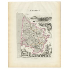
Carte de la Gironde en France avec la région viticole de Bordeaux par Vuillemin, C.C.
Carte de la Gironde en France avec la région viticole de Bordeaux par Vuillemin, C.C.
Cette étonnante carte de la Gironde, en France, datant du XIXe siècle, fait partie du Nouvel At...
Catégorie
Antiquités, Milieu du XIXe siècle, Français, Cartes
Matériaux
Papier
Map of Aisne France with Soissons and Champagne Vineyards by Vuillemin, 19th c
Map of Aisne France with Soissons and Champagne Vineyards by Vuillemin, 19th c
Description:
This richly detailed 19th-century engraved and hand-colored map of the department of Aisn...
Catégorie
Antiquités, Milieu du XIXe siècle, Français, Cartes
Matériaux
Papier

Suggestions
Grande carte de France du 19ème siècle
Grande carte de France du 19e siècle.
Remarquable état de conservation, avec une patine d'usage agréable.
Récemment encadré.
France Circa 1874.
Catégorie
Antiquités, Fin du XIXe siècle, Français, Cartes
Matériaux
Lin, Papier

Var, France. Carte ancienne d'un département français, 1856
Par Victor Levasseur
département du Var", gravure sur acier avec contour original coloré à la main, 1856, de l'Atlas National Illustre de Levasseur.
Le Var couvre le cœur de la Côte d'Azur et comprend ...
Catégorie
XIXe siècle, Naturalisme, Estampes - Paysage
Matériaux
Gravure

Saone et Loire, France. Carte ancienne d'un département français, 1856
Par Victor Levasseur
département de Saône et Loire", gravure sur acier avec contour original coloré à la main, 1856, de l'Atlas national illustré de Levasseur.
Le département français de la Saône et Lo...
Catégorie
XIXe siècle, Naturalisme, Estampes - Paysage
Matériaux
Gravure

Aude, France. Carte ancienne d'un département français, 1856
Par Victor Levasseur
département de l'Aude, gravure sur acier avec contour original coloré à la main, 1856, de l'Atlas national illustré de Levasseur.
Cette région de France est célèbre pour sa grande ...
Catégorie
XIXe siècle, Naturalisme, Estampes - Paysage
Matériaux
Gravure

France, partie nord. Carte de l'Atlas du siècle
L'Atlas du siècle. France, partie nord".
Carte originale ancienne, 1903.
Cartes en médaillon de "La France en provinces" et de "Paris et ses environs".
Pli central tel que publié. ...
Catégorie
Début du 20ème siècle, Victorien, Plus d'Estampes
Matériaux
Lithographie

Carte de la France - Gravure - 1820
Carte de France est une Gravure originale réalisée par un artiste inconnu du 19ème siècle en 1820.
Très bon état sur deux feuilles de papier blanc jointes au centre.
La carte est u...
Catégorie
années 1820, Moderne, Estampes - Figuratif
Matériaux
Eau-forte
