Articles similaires à Map of Southern South America – Richly Detailed Engraving by K.Johnston, 1903

Vous voulez plus d'images ou de vidéos ?
Demander au vendeur plus d'images ou de vidéos
1 sur 10
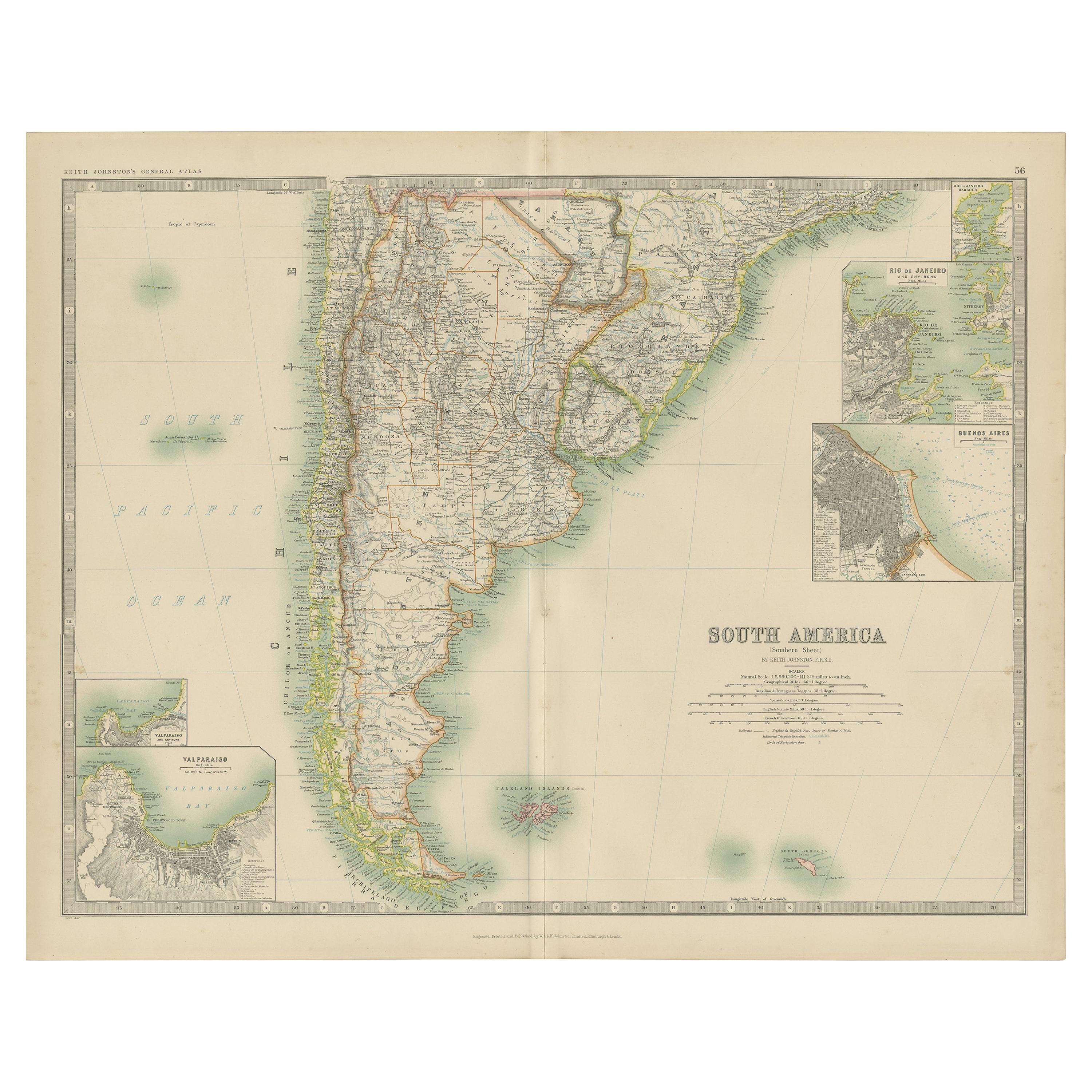
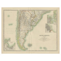
Map of Southern South America – Richly Detailed Engraving by K.Johnston, 1903
À propos de cet article
Title (80 characters, keyword-first):
Map of Southern South America – Richly Detailed Engraving by Keith Johnston, 1903
Description:
This elegant map titled "South America: Southern Sheet" was created by Keith Johnston, F.R.G.S., and published by W. & A.K. Johnston, Limited, Edinburgh & London, in 1903. It offers a meticulous and visually engaging depiction of the southern part of the South American continent, encompassing Argentina, Chile, Uruguay, and parts of Paraguay and southern Brazil.
The map captures key features such as the rugged Andes mountain range running along Chile’s border, the vast Pampas of Argentina, and the intricate coastline dotted with islands and inlets. In the southern reaches, the map details the archipelagos of Tierra del Fuego and the isolated Falkland Islands and South Georgia Island in the South Atlantic.
Rich with period-accurate details, the map includes rivers, mountain ranges, cities, and transportation routes. Its finely engraved lines and gentle color shading bring the topography and political boundaries to life, offering a striking visual representation of early 20th-century South America.
Condition-wise, the map is in excellent shape for its age, with clear printing, vibrant colors, and minimal signs of handling or foxing. This map’s historical and geographical significance makes it a prized addition to any collection.
For framing, consider using a warm-toned wooden frame or a dark brown frame to complement the map’s elegant color scheme, with a neutral mat to highlight the fine engravings. Whether displayed in a study, library, or office, this map is a captivating window into the landscapes and political divisions of South America at the dawn of the 20th century.
- Dimensions:Hauteur : 36,8 cm (14,49 po)Largeur : 47 cm (18,51 po)Profondeur : 0,2 mm (0,01 po)
- Matériaux et techniques:
- Période:
- Date de fabrication:1903
- État:Condition-wise, the map is in excellent shape for its age, with clear printing, vibrant colors, and minimal signs of handling or foxing. This map’s historical and geographical significance makes it a prized addition to any collection.
- Adresse du vendeur:Langweer, NL
- Numéro de référence:Vendeur : BG-13577-511stDibs : LU3054345292142
À propos du vendeur
5,0
Vendeur reconnu
Ces vendeurs prestigieux sont des leaders du secteur. Ils représentent le summum en matière de qualité et de design.
Vendeur Or
Vendeurs premium dont la note est supérieure à 4,3 et le délai de réponse de 24 heures maximum
Établi en 2009
Vendeur 1stDibs depuis 2017
2 462 ventes sur 1stDibs
Temps de réponse habituel : <1 heure
- ExpéditionRecherche du devis...Expédition depuis : Langweer, Pays-Bas
- Politique des retours
Certaines parties de cette page ont été traduites automatiquement. 1stDibs ne garantit pas l'exactitude des traductions. L'anglais est la langue par défaut de ce site web.
Garantie d'authenticité
Bien qu'il soit peu probable que la situation se présente, dans le cas où vous rencontreriez un problème d'authenticité d'un article, contactez-nous dans un délai d'un an pour obtenir un remboursement intégral. DétailsGarantie de remboursement
Si votre article n'est pas conforme à la description, est endommagé pendant le transport ou ne vous est pas livré, contactez-nous sous 7 jours pour obtenir un remboursement intégral. DétailsAnnulation sous 24 heures
Vous disposez d'un délai de 24 heures pour annuler votre achat sans motif.Des vendeurs professionnels agréés
Nos vendeurs de renommée mondiale doivent respecter des normes strictes en matière de service et de qualité, afin de préserver l'intégrité de nos fiches produit.Garantie d'alignement des prix
Si vous constatez qu'un autre vendeur a mis en vente le même article à un prix inférieur sur un autre site, nous nous alignerons sur ce prix.Livraison en toute confiance à l'international
Notre réseau de transporteurs de premier ordre propose des options d'expédition spécialisées dans le monde entier, y compris des livraisons personnalisées.Plus d'articles de ce vendeur
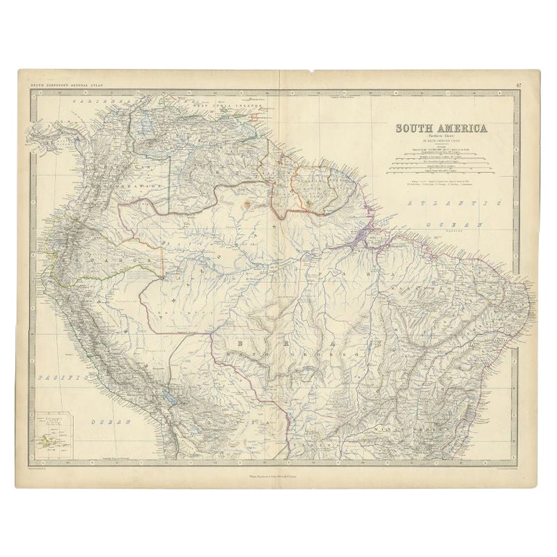
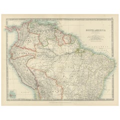
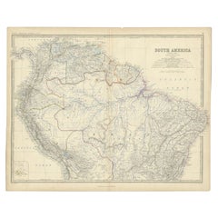
Tout afficherMap of Northern South America – Vibrant Engraving by Keith Johnston, 1903
Map of Northern South America – Vibrant Engraving by Keith Johnston, 1903
This beautifully engraved map titled "South America: Northern Sheet" was created by Keith Johnston, F.R.G.S...
Catégorie
Début du 20ème siècle, Cartes
Matériaux
Papier
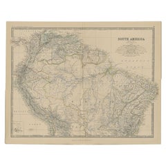
Carte ancienne d'Amérique du Sud par Johnston '1909'
Carte ancienne intitulée "South America, Southern Sheet". Des images du Chili, de l'Argentine, du Brésil, de la Patagonie, de l'île Falkland et plus encore. Avec des cartes en médail...
Catégorie
Début du 20ème siècle, Cartes
Matériaux
Papier
232 $US Prix de vente
20 % de remise
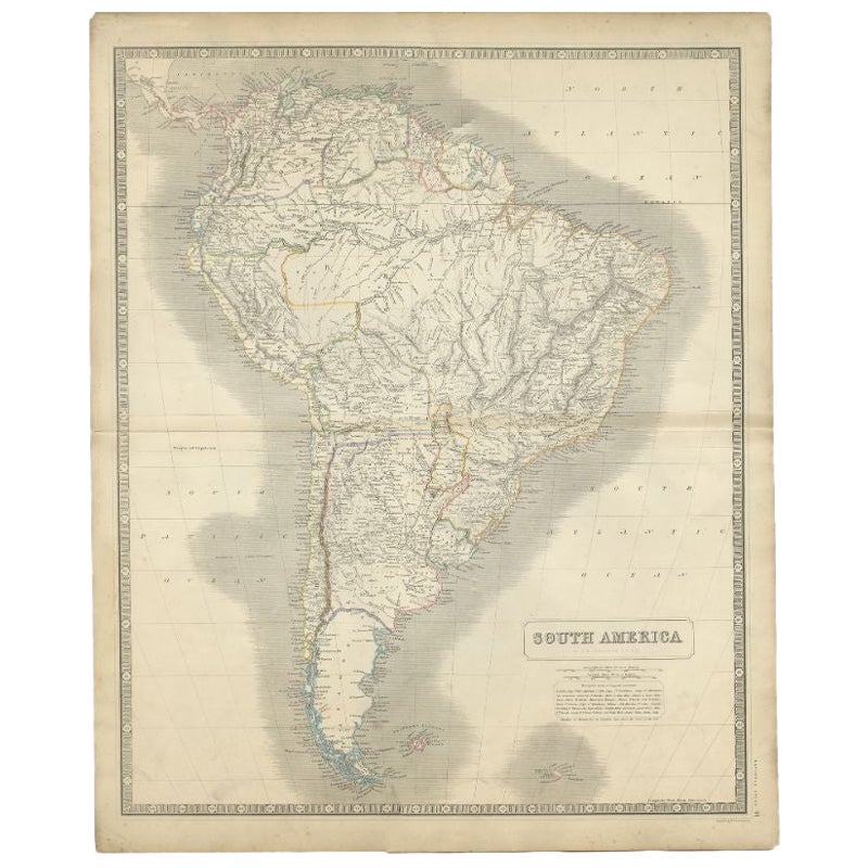
Carte ancienne d'Amérique du Sud par Johnston, 1882
Carte ancienne intitulée "Amérique du Sud". Ancienne carte de l'Amérique du Sud, avec un encart des îles Galapagos. Cette carte provient de "The Royal Atlas of Modern Geography, Exhi...
Catégorie
Antiquités, XIXe siècle, Cartes
Matériaux
Papier
133 $US Prix de vente
20 % de remise
Carte ancienne d'Amérique du Sud par Johnston, 1861
Carte ancienne intitulée 'South America'.
Ancienne carte de l'Amérique du Sud, avec une carte des îles Galapagos en médaillon. Cette carte est tirée de "The Royal Atlas of Modern G...
Catégorie
Antiquités, XIXe siècle, Cartes
Matériaux
Papier
Carte ancienne d'Amérique du Sud par Johnston, 1844
Carte antitique intitulée "Amérique du Sud". Belle carte originale et ancienne de l'Amérique du Sud. Cette carte est tirée de "The National Atlas of Historical, Commercial and Politi...
Catégorie
Antiquités, XIXe siècle, Cartes
Matériaux
Papier

181 $US Prix de vente
20 % de remise
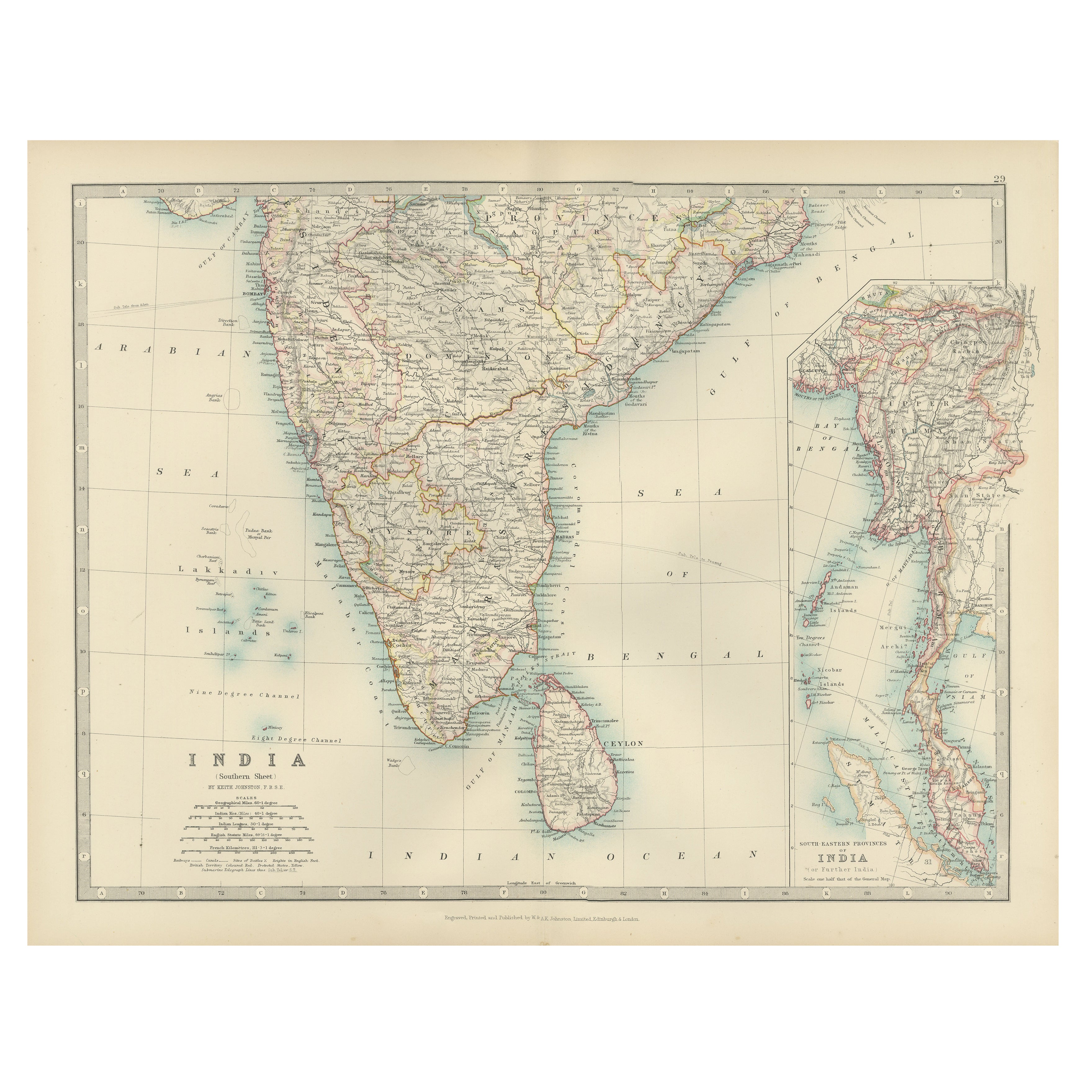
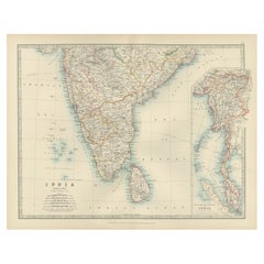
Antique Map of Southern India and South Eastern Provinces, 1903
Title: Antique Map of Southern India and South Eastern Provinces, 1903, with Intricate Detail
Description:
This antique map, titled "India (Southern Sheet) and the South Eastern Pro...
Catégorie
Début du 20ème siècle, Cartes
Matériaux
Papier
Suggestions
Carte ancienne de l'État américain du Michigan (partie sud du Michigan), 1903
Carte ancienne du Michigan (partie sud)
Publié par A.I.C Black. 1903
Couleur originale
Bon état
Sans cadre.
Expédition gratuite
Catégorie
Antiquités, Début des années 1900, Anglais, Cartes
Matériaux
Papier

49 $US
Livraison gratuite
Carte ancienne de l'État américain de l'Ohio (partie sud de l'Ohio), 1903
Carte ancienne de l'Ohio (partie sud)
Publié par A.I.C Black. 1903
Couleur originale
Bon état
Sans cadre.
Expédition gratuite
Catégorie
Antiquités, Début des années 1900, Anglais, Cartes
Matériaux
Papier

Carte ancienne de l'État américain de Californie (partie sud), 1903
Carte ancienne de la Californie (partie sud)
Publié par A.I.C Black. 1903
Couleur originale
Bon état
Sans cadre.
Expédition gratuite
Catégorie
Antiquités, Début des années 1900, Anglais, Cartes
Matériaux
Papier

Carte ancienne de l'État américain de l'Illinois (partie sud de l'Illinois), 1903
Carte ancienne de l'Illinois (partie sud)
Publié par A.I.C Black. 1903
Couleur originale
Bon état
Sans cadre.
Expédition gratuite
Catégorie
Antiquités, Début des années 1900, Anglais, Cartes
Matériaux
Papier

49 $US
Livraison gratuite
Carte ancienne de l'État américain du Missouri (partie sud du Missouri), 1903
Carte ancienne du Missouri (partie sud)
Publié par A.I.C Black. 1903
Couleur originale
Bon état
Sans cadre.
Expédition gratuite
Catégorie
Antiquités, Début des années 1900, Anglais, Cartes
Matériaux
Papier

49 $US
Livraison gratuite
Carte ancienne originale de l'Etat américain de South Carolina, 1903
Antique map of South Carolina
Published By A & C Black. 1903
Original colour
Good condition
Unframed.
Free shipping
Catégorie
Antiquités, Début des années 1900, Anglais, Cartes
Matériaux
Papier
