Articles similaires à Map of United States Central Sheet 1903 – Railroads, States, and Topography


Vous voulez plus d'images ou de vidéos ?
Demander au vendeur plus d'images ou de vidéos
1 sur 10
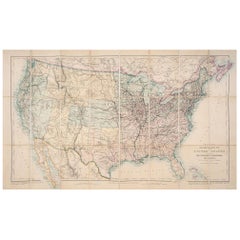
Map of United States Central Sheet 1903 – Railroads, States, and Topography
À propos de cet article
Map of United States Central Sheet 1903 – Railroads, States, and Topography
This is a finely engraved and beautifully colored map titled "United States of North America (Central Sheet)," created by Keith Johnston and printed by W. & A.K. Johnston, Ltd., in London and Edinburgh. This antique map, dating to the early 20th century, showcases the heartland of the United States in meticulous detail, spanning from the Gulf of Mexico up through the Great Lakes region.
The map covers the states of Texas, Oklahoma, Kansas, Nebraska, the Dakotas, Minnesota, Wisconsin, Iowa, Missouri, and Illinois, with surrounding areas of Colorado, Wyoming, Michigan, Arkansas, and Louisiana. Key features include railroad networks that highlight the rapid industrial expansion of the time, major rivers and mountain ranges, county boundaries, and settlements. The shading and contouring beautifully depict the topography, while delicate hand-coloring demarcates state boundaries with elegant clarity.
Inset with a detailed scale and a small table of mileages, the map is a testament to both the artistry and precision of historical cartography. The typography is crisp and classic, conveying both geographical and cultural importance for historians, map enthusiasts, and collectors.
Condition is very good for its age, with only minimal signs of wear and slight toning around the edges, consistent with gentle handling over the decades. The colors remain vibrant, enhancing the visual appeal of this historical piece.
For framing, consider a traditional dark wood frame to complement the antique style, or a simple black frame to modernize the look while preserving the map’s elegance. A neutral cream or off-white mat would highlight the engraved details and colors. This map would make a wonderful display for a home library, study, or any setting that celebrates American history.
- Dimensions:Hauteur : 47 cm (18,51 po)Largeur : 36,8 cm (14,49 po)Profondeur : 0,2 mm (0,01 po)
- Matériaux et techniques:
- Période:
- Date de fabrication:1903
- État:Condition is very good for its age, with only minimal signs of wear and slight toning around the edges, consistent with gentle handling over the decades. The colors remain vibrant, enhancing the visual appeal of this historical piece.
- Adresse du vendeur:Langweer, NL
- Numéro de référence:Vendeur : BG-13577-471stDibs : LU3054345291852
À propos du vendeur
5,0
Vendeur reconnu
Ces vendeurs prestigieux sont des leaders du secteur. Ils représentent le summum en matière de qualité et de design.
Vendeur Or
Vendeurs premium dont la note est supérieure à 4,3 et le délai de réponse de 24 heures maximum
Établi en 2009
Vendeur 1stDibs depuis 2017
2 463 ventes sur 1stDibs
Temps de réponse habituel : <1 heure
- ExpéditionRecherche du devis...Expédition depuis : Langweer, Pays-Bas
- Politique des retours
Certaines parties de cette page ont été traduites automatiquement. 1stDibs ne garantit pas l'exactitude des traductions. L'anglais est la langue par défaut de ce site web.
Garantie d'authenticité
Bien qu'il soit peu probable que la situation se présente, dans le cas où vous rencontreriez un problème d'authenticité d'un article, contactez-nous dans un délai d'un an pour obtenir un remboursement intégral. DétailsGarantie de remboursement
Si votre article n'est pas conforme à la description, est endommagé pendant le transport ou ne vous est pas livré, contactez-nous sous 7 jours pour obtenir un remboursement intégral. DétailsAnnulation sous 24 heures
Vous disposez d'un délai de 24 heures pour annuler votre achat sans motif.Des vendeurs professionnels agréés
Nos vendeurs de renommée mondiale doivent respecter des normes strictes en matière de service et de qualité, afin de préserver l'intégrité de nos fiches produit.Garantie d'alignement des prix
Si vous constatez qu'un autre vendeur a mis en vente le même article à un prix inférieur sur un autre site, nous nous alignerons sur ce prix.Livraison en toute confiance à l'international
Notre réseau de transporteurs de premier ordre propose des options d'expédition spécialisées dans le monde entier, y compris des livraisons personnalisées.Plus d'articles de ce vendeur
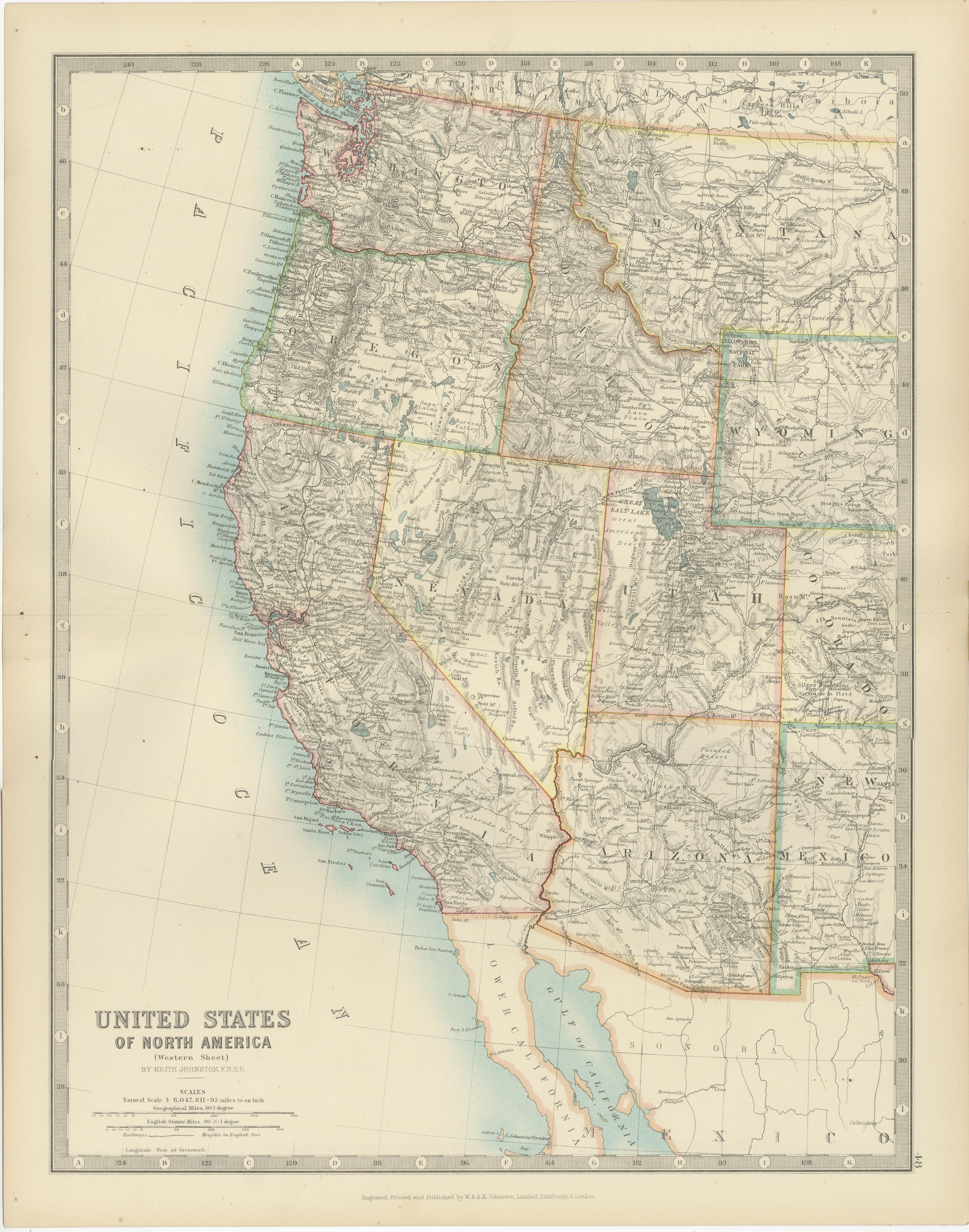
Tout afficherMap of Western United States 1903 – Railroads, State Borders, and Terrain
Map of Western United States 1903 – Railroads, State Borders, and Terrain
This beautifully engraved map titled "United States of North America (Western Sheet)" was created by Keith ...
Catégorie
Début du 20ème siècle, Cartes
Matériaux
Papier

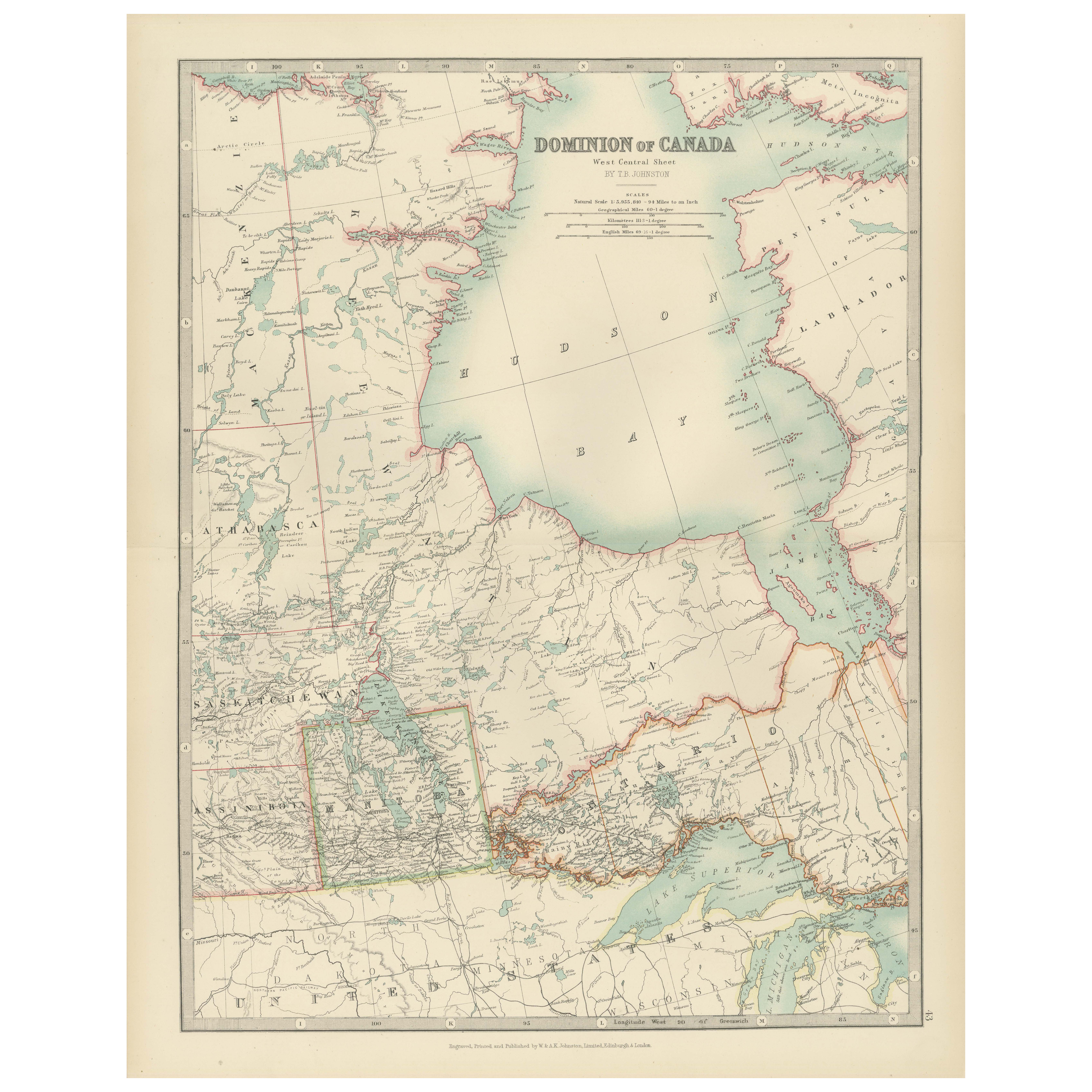
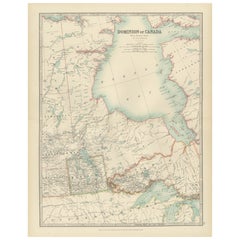
Canada Map 1903 - Dominion of Canada, West Central Sheet
Title: Canada Map 1903 - Dominion of Canada, West Central Sheet
Description:
This fascinating 1903 map of the Dominion of Canada’s West Central regions by T.R. Johnston offers a viv...
Catégorie
Début du 20ème siècle, Cartes
Matériaux
Papier
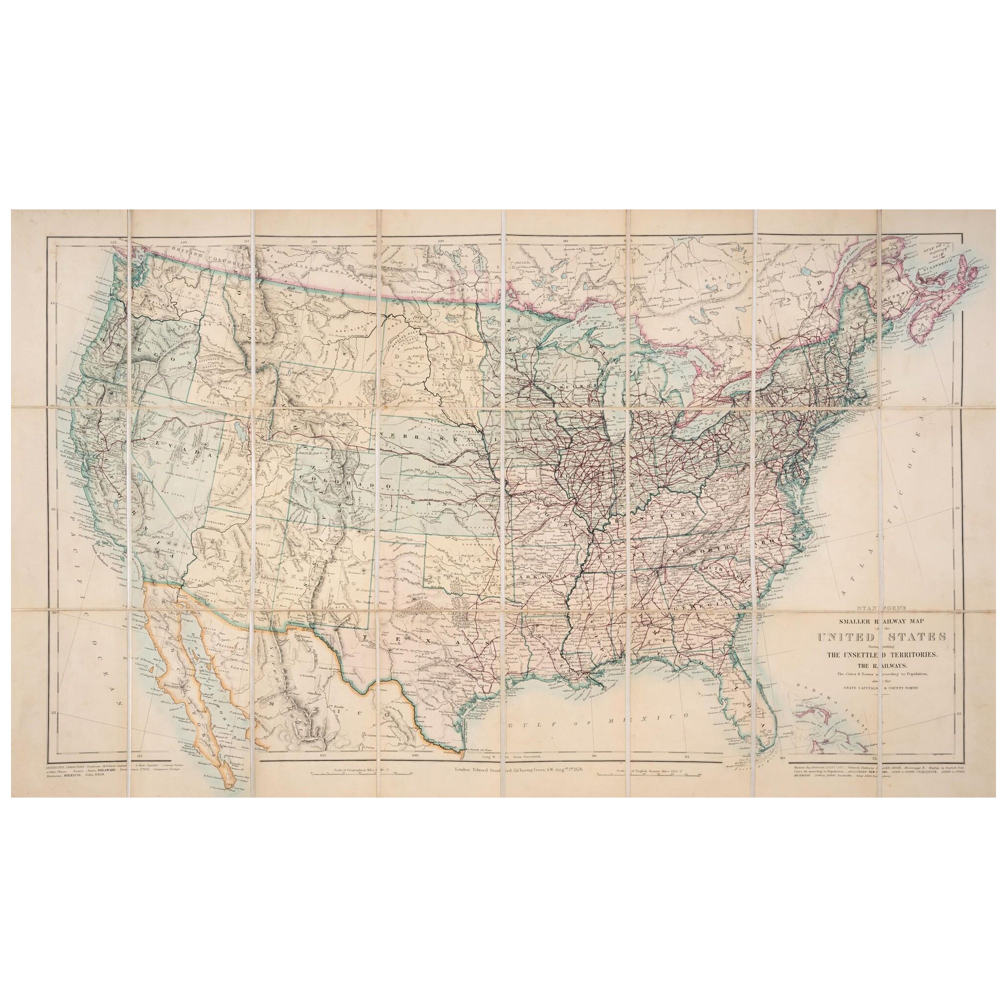
1876 Carte des Etats-Unis : Détails des chemins de fer et des territoires non colonisés
Carte ferroviaire réduite des États-Unis de Stanford, 1876
Cette carte originale de 1876, intitulée "Stanford's Smaller Railway Map of the United States Distinguishing the Unsettled...
Catégorie
Antiquités, années 1870, Cartes
Matériaux
Papier
Carte ancienne des chemins de fer des États-Unis par Rand, McNally & Co, 1900
Carte ancienne intitulée "Rand, McNally & Co's New Official Railroad map of the United States with portions of The Dominion of Canada, The Republic of Mexico and the West Indies". Gr...
Catégorie
20ième siècle, Cartes
Matériaux
Lin, Papier

2 180 $US Prix de vente
25 % de remise
Livraison gratuite
Petite carte des États-Unis
Carte ancienne intitulée "Amérique septe. Physique". Petite carte des Etats-Unis. lithographiée par les frères C.Callewaert à Bruxelles vers 1870.
Catégorie
Antiquités, Milieu du XIXe siècle, Cartes
Matériaux
Papier

69 $US Prix de vente
20 % de remise
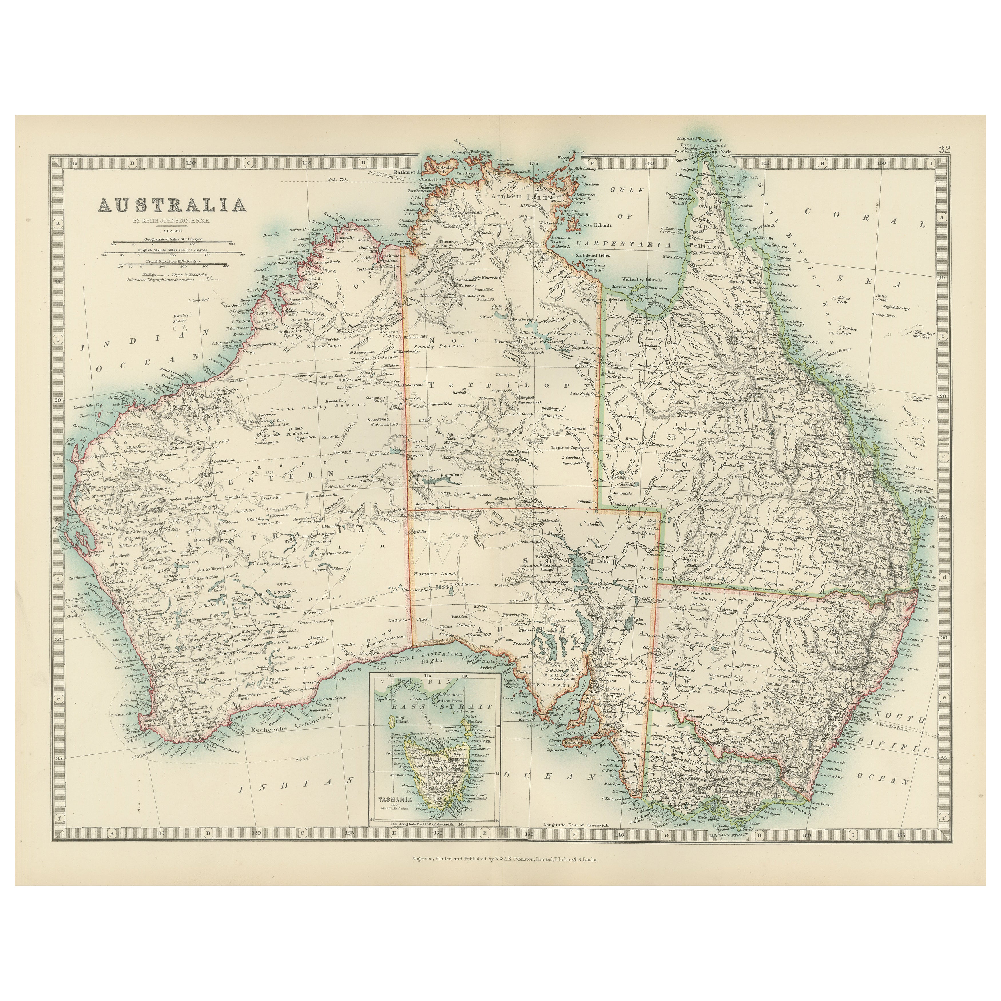
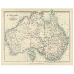
Antique Map of Australia, 1903, with Colonial Divisions and Detailed Topography
Title: Antique Map of Australia, 1903, with Colonial Divisions and Detailed Topography
Description: This antique map, titled "Australia," was engraved and published in 1903 by W. & ...
Catégorie
Début du 20ème siècle, Cartes
Matériaux
Papier
Suggestions
Carte vintage des États-Unis encadrée
Carte des Etats-Unis vintage en papier vieilli montée sur panneau de particules et encadrée dans un cadre en bois simple.
Catégorie
20ième siècle, Américain, Mid-Century Modern, Cartes
Matériaux
Bois, Papier

Carte encadrée Mexique et États-Unis de 1830
Carte de l'Amérique du Nord publiée vers 1830. La carte montre les États-Unis au Canada. Le Mexique s'étend jusqu'au territoire de la haute Californie. Le Texas apparaît dans le nom ...
Catégorie
Antiquités, années 1830, Américain, Classique américain, Cartes
Matériaux
Verre, Bois, Papier

Carte ancienne originale des États-Unis, Grattan et Gilbert, 1843
Grande carte des États-Unis
Dessiné et gravé par Archer
Publié par Grattan et Gilbert. 1843
Couleur originale
Non encadré.
Catégorie
Antiquités, années 1840, Anglais, Cartes
Matériaux
Papier

Carte des États-Unis des années 1820 encadrée et colorée à la main
Photos encadrées de cartes de l'Amérique du Nord et de l'Amérique du Sud datant des années 1820, colorées à la main. Tel que trouvé, encadré dans un cadre en bois doré.
Catégorie
Antiquités, années 1820, Américain, Colonial espagnol, Cartes
Matériaux
Bois doré, Papier, Verre

Carte des États-Unis colorée à la main encadrée 1839
Carte encadrée des Etats-Unis d'Amérique de 1839, coloriée à la main. Nouvellement encadré dans un cadre en bois doré.
Catégorie
Antiquités, années 1830, Américain, Classique américain, Cartes
Matériaux
Bois doré, Papier, Verre

« Map of the United States of America..." de 1859 par J. H. Colton
Par J.H. Colton
La carte présentée est une "Carte des États-Unis d'Amérique, des provinces britanniques, du Mexique, des Antilles et de l'Amérique centrale avec une partie de la Nouvelle-Grenade et ...
Catégorie
Antiquités, années 1850, Américain, Cartes
Matériaux
Papier
