Articles similaires à Map of Western United States 1903 – Railroads, State Borders, and Terrain


Vous voulez plus d'images ou de vidéos ?
Demander au vendeur plus d'images ou de vidéos
1 sur 11
Map of Western United States 1903 – Railroads, State Borders, and Terrain
À propos de cet article
Map of Western United States 1903 – Railroads, State Borders, and Terrain
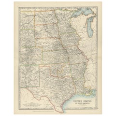
This beautifully engraved map titled "United States of North America (Western Sheet)" was created by Keith Johnston and published by W. & A.K. Johnston, Ltd. in London and Edinburgh, around 1903. It captures the western portion of the United States during a transformative period, showcasing states such as California, Oregon, Washington, Nevada, Idaho, Utah, Arizona, New Mexico, and parts of Montana, Wyoming, and Colorado.
This map is rich with historical detail, including an intricate network of railroads, key to the development of the western frontier in the early 20th century. State and county boundaries are carefully colored, while major rivers, mountain ranges, and settlements are precisely engraved, offering a glimpse into the growth of infrastructure and commerce. The typography is clean and refined, with town names, mountain peaks, and railway lines meticulously labeled.
Particularly interesting is the depiction of topography through delicate hachuring and shading, which brings the rugged beauty of the western landscape to life. The map also hints at the political and economic aspirations of the era, reflecting the westward expansion that defined the American experience.
The condition of this map is excellent for its age, with light toning around the edges and crisp, vibrant color that highlights the states and regions. It retains its charm and historical significance, making it a remarkable addition to any collection of antique maps or Americana.
For framing, a classic wooden frame in dark or natural tones would complement the historical aesthetic, while a neutral cream or soft tan mat would allow the detailed engravings to stand out. This map would make a wonderful centerpiece in an office, library, or living space, celebrating the rich heritage of the American West.
- Dimensions:Hauteur : 47 cm (18,51 po)Largeur : 36,8 cm (14,49 po)Profondeur : 0,2 mm (0,01 po)
- Matériaux et techniques:
- Période:
- Date de fabrication:1903
- État:The condition is excellent for its age, with light toning around the edges and crisp, vibrant color that highlights the states and regions. It retains its charm and historical significance, making it a remarkable addition to any collection.
- Adresse du vendeur:Langweer, NL
- Numéro de référence:Vendeur : BG-13577-481stDibs : LU3054345291982
À propos du vendeur
5,0
Vendeur reconnu
Ces vendeurs prestigieux sont des leaders du secteur. Ils représentent le summum en matière de qualité et de design.
Vendeur Or
Vendeurs premium dont la note est supérieure à 4,3 et le délai de réponse de 24 heures maximum
Établi en 2009
Vendeur 1stDibs depuis 2017
2 463 ventes sur 1stDibs
Temps de réponse habituel : <1 heure
- ExpéditionRecherche du devis...Expédition depuis : Langweer, Pays-Bas
- Politique des retours
Certaines parties de cette page ont été traduites automatiquement. 1stDibs ne garantit pas l'exactitude des traductions. L'anglais est la langue par défaut de ce site web.
Garantie d'authenticité
Bien qu'il soit peu probable que la situation se présente, dans le cas où vous rencontreriez un problème d'authenticité d'un article, contactez-nous dans un délai d'un an pour obtenir un remboursement intégral. DétailsGarantie de remboursement
Si votre article n'est pas conforme à la description, est endommagé pendant le transport ou ne vous est pas livré, contactez-nous sous 7 jours pour obtenir un remboursement intégral. DétailsAnnulation sous 24 heures
Vous disposez d'un délai de 24 heures pour annuler votre achat sans motif.Des vendeurs professionnels agréés
Nos vendeurs de renommée mondiale doivent respecter des normes strictes en matière de service et de qualité, afin de préserver l'intégrité de nos fiches produit.Garantie d'alignement des prix
Si vous constatez qu'un autre vendeur a mis en vente le même article à un prix inférieur sur un autre site, nous nous alignerons sur ce prix.Livraison en toute confiance à l'international
Notre réseau de transporteurs de premier ordre propose des options d'expédition spécialisées dans le monde entier, y compris des livraisons personnalisées.Plus d'articles de ce vendeur
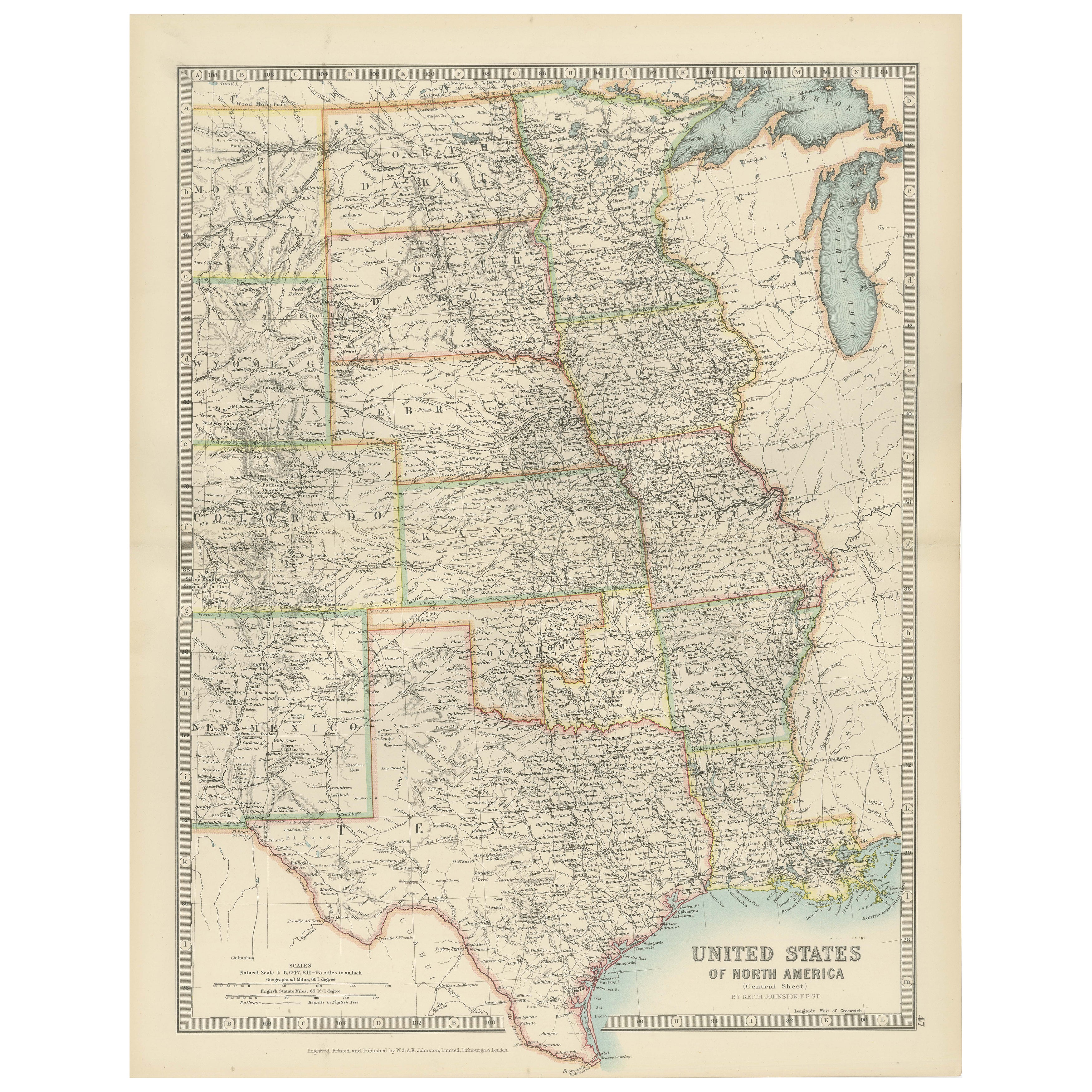
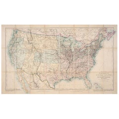
Tout afficherMap of United States Central Sheet 1903 – Railroads, States, and Topography
Map of United States Central Sheet 1903 – Railroads, States, and Topography
This is a finely engraved and beautifully colored map titled "United States of North America (Central She...
Catégorie
Début du 20ème siècle, Cartes
Matériaux
Papier
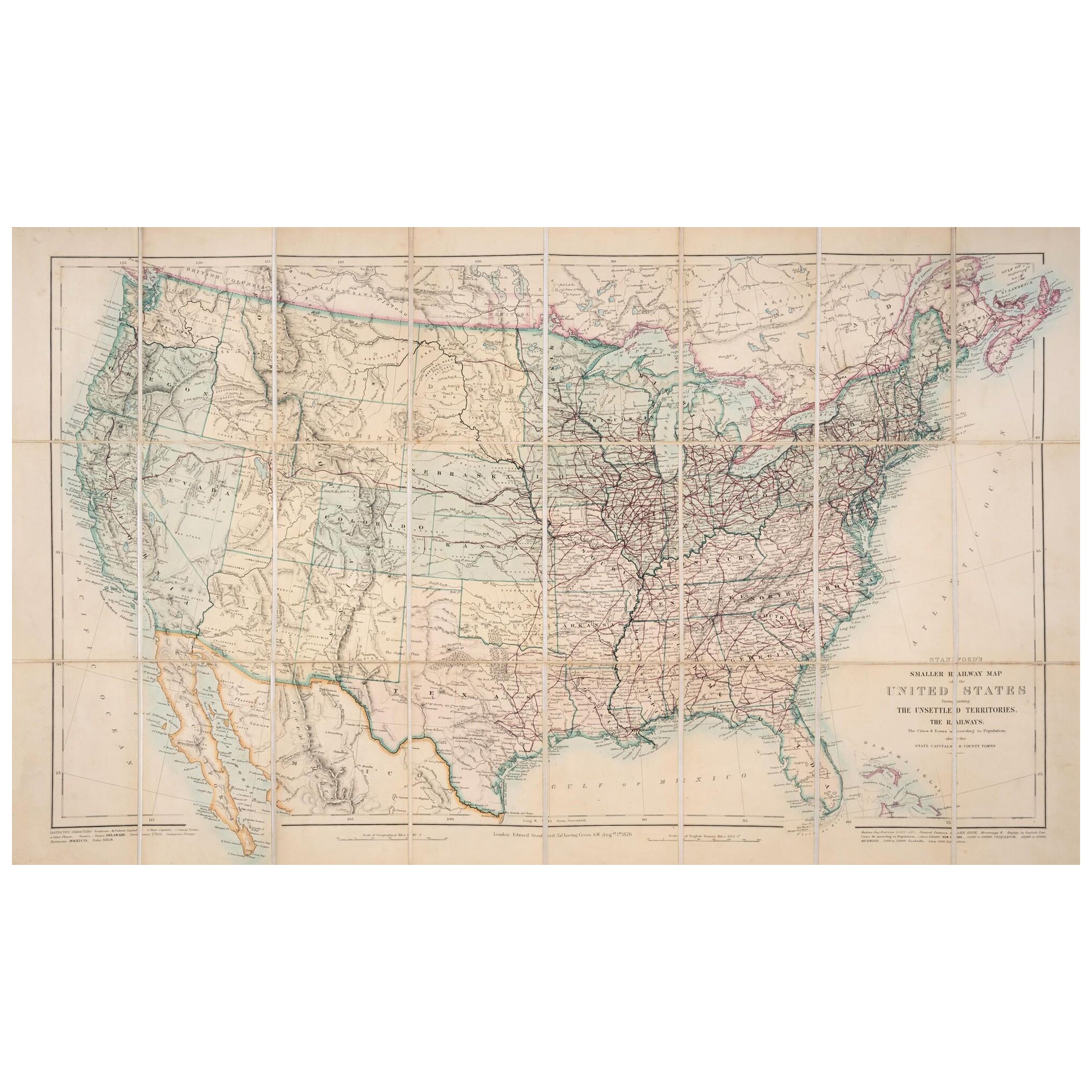
1876 Carte des Etats-Unis : Détails des chemins de fer et des territoires non colonisés
Carte ferroviaire réduite des États-Unis de Stanford, 1876
Cette carte originale de 1876, intitulée "Stanford's Smaller Railway Map of the United States Distinguishing the Unsettled...
Catégorie
Antiquités, années 1870, Cartes
Matériaux
Papier
Carte ancienne des chemins de fer des États-Unis par Rand, McNally & Co, 1900
Carte ancienne intitulée "Rand, McNally & Co's New Official Railroad map of the United States with portions of The Dominion of Canada, The Republic of Mexico and the West Indies". Gr...
Catégorie
20ième siècle, Cartes
Matériaux
Lin, Papier

2 180 $US Prix de vente
25 % de remise
Livraison gratuite
Petite carte des États-Unis
Carte ancienne intitulée "Amérique septe. Physique". Petite carte des Etats-Unis. lithographiée par les frères C.Callewaert à Bruxelles vers 1870.
Catégorie
Antiquités, Milieu du XIXe siècle, Cartes
Matériaux
Papier

69 $US Prix de vente
20 % de remise
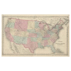
Carte ancienne des États-Unis d'Amérique de Colton
Carte ancienne intitulée "Colton's United States of America". Représenter les chemins de fer, les canaux, les capitales des États, les principales villes, les postes militaires, les ...
Catégorie
Antiquités, Milieu du XIXe siècle, Cartes
Matériaux
Papier
827 $US Prix de vente
20 % de remise
Carte ancienne des États-Unis d'Amérique du Nord, États-Unis du Pacifique, 1882
La carte est tirée du même atlas Blackie de 1882 et se concentre sur les États du Pacifique des États-Unis d'Amérique à cette époque. Voici quelques détails et le contexte historique...
Catégorie
Antiquités, années 1880, Cartes
Matériaux
Papier

232 $US Prix de vente
20 % de remise
Livraison gratuite
Suggestions
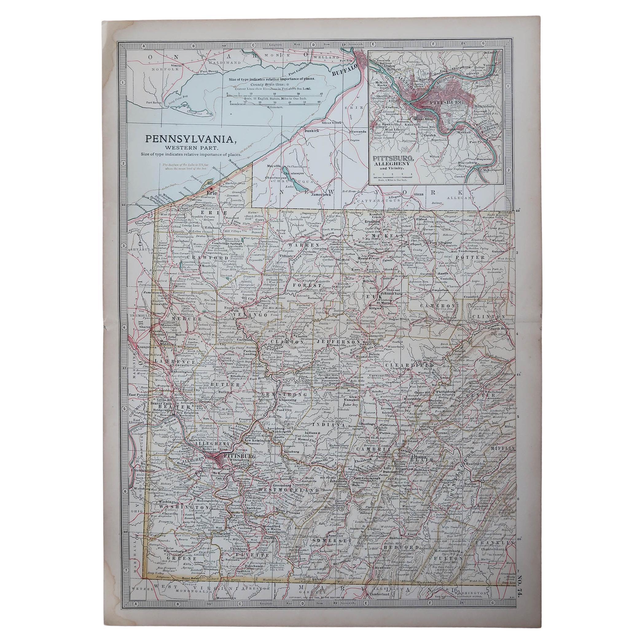
Carte ancienne de l'État américain de Pennsylvanie (partie occidentale ), 1903
Antique map of Pennsylvania ( Western part )
Published By A & C Black. 1903
Original colour
Good condition
Unframed.
Free shipping
Catégorie
Antiquités, Début des années 1900, Anglais, Cartes
Matériaux
Papier

49 $US
Livraison gratuite
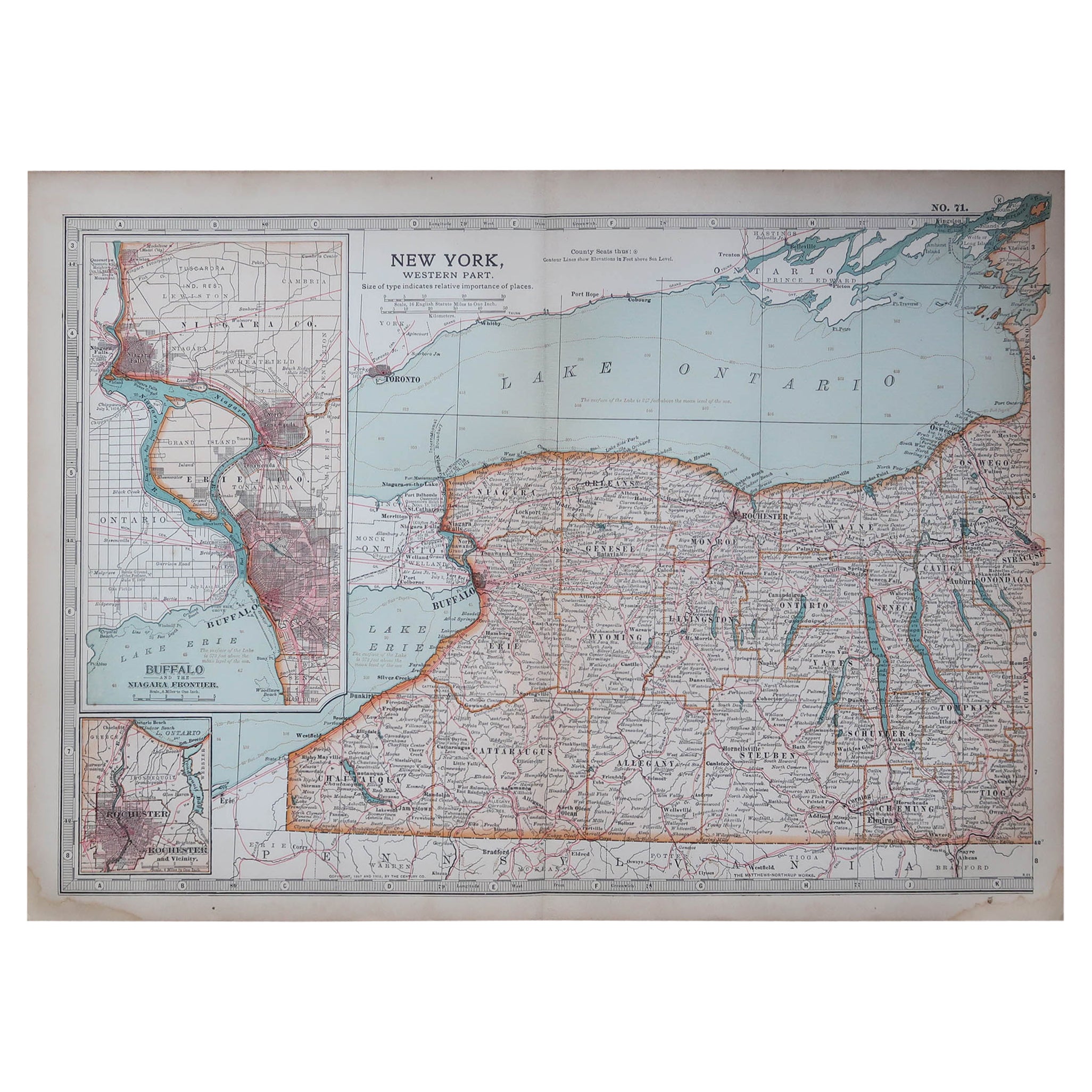
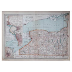
Carte ancienne de l'État américain de New York (partie occidentale) 1903
Antique map of New York ( Western Part )
Published By A & C Black. 1903
Original colour
Good condition
Unframed.
Free shipping
Catégorie
Antiquités, Début des années 1900, Anglais, Cartes
Matériaux
Papier
Carte vintage des États-Unis encadrée
Carte des Etats-Unis vintage en papier vieilli montée sur panneau de particules et encadrée dans un cadre en bois simple.
Catégorie
20ième siècle, Américain, Mid-Century Modern, Cartes
Matériaux
Bois, Papier

Carte encadrée Mexique et États-Unis de 1830
Carte de l'Amérique du Nord publiée vers 1830. La carte montre les États-Unis au Canada. Le Mexique s'étend jusqu'au territoire de la haute Californie. Le Texas apparaît dans le nom ...
Catégorie
Antiquités, années 1830, Américain, Classique américain, Cartes
Matériaux
Verre, Bois, Papier

Carte ancienne originale des États-Unis, Grattan et Gilbert, 1843
Grande carte des États-Unis
Dessiné et gravé par Archer
Publié par Grattan et Gilbert. 1843
Couleur originale
Non encadré.
Catégorie
Antiquités, années 1840, Anglais, Cartes
Matériaux
Papier

Carte ancienne de l'État américain du Minnesota, 1903
Carte ancienne du Minnesota
Publié par A.I.C Black. 1903
Couleur originale
Bon état
Sans cadre.
Expédition gratuite
Catégorie
Antiquités, Début des années 1900, Anglais, Cartes
Matériaux
Papier
