(After) Basilius Besler Landscape Prints
to
1
Overall Width
to
Overall Height
to
1
169
158
146
131
1
1
1
1
Artist: (After) Basilius Besler
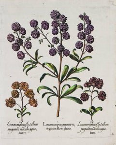
Three Varieties of Leucoium , Hortus Eystettensis, ( after ) Besler
By (After) Basilius Besler
Located in Paonia, CO
Three Varieties of Leucoium (I. Leucoium purpureum variegatum flore pleno. II Leucoium pleno flor album purpureis maculis signatum. III. Leucoium pleno flor album sanguine maculis signatum), from B. Besler, Hortus Eystettensis possibly (after) Basil Besler...
Category
Early 17th Century (After) Basilius Besler Landscape Prints
Materials
Engraving
Related Items
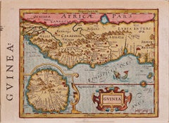
West Africa: A 17th Century Hand-Colored Map by Mercator/Hondius
By Gerard Mercator
Located in Alamo, CA
A 17th century hand-colored map entitled "Guineae Nova Descriptio" by Gerard Mercator and Jodocus Hondius, published in their 'Atlas Minor' in Amsterdam in 1635. It is focused on the...
Category
1630s (After) Basilius Besler Landscape Prints
Materials
Engraving
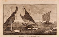
Boats of the Friendly Isles, Tonga: Original 18th C. Engraving from Captain Cook
By William Hodges
Located in Alamo, CA
"Boats of the Friendly Isles" is an original 18th century engraving from a drawing by William Hodges (1744-1797), who was the artist who accompanies Captain Cook on his second voyage...
Category
1780s (After) Basilius Besler Landscape Prints
Materials
Engraving
A View of Kauai, Hawaii Discovered by Captain Cook: Original 18th C. Engraving
By John Webber
Located in Alamo, CA
"View of A Morai or Burial Place of Atooi, One of the Sandwich Islands (Kauai, Hawaii)" is an original 18th century engraving from a drawing by John Webber (1751-1793), who was the a...
Category
1780s (After) Basilius Besler Landscape Prints
Materials
Engraving
$225
H 9.75 in W 15.25 in
Reception for Captain Cook, Tonga: Original 18th C. Engraving, Cook's 3rd Voyage
By John Webber
Located in Alamo, CA
"The Reception of Capt. Cook in Hapaee" is an original 18th century engraving from a drawing by John Webber (1751-1793), who was the artist who accompanied Captain Cook on his third ...
Category
1780s (After) Basilius Besler Landscape Prints
Materials
Engraving
Canterbury: An Original 16th C. Framed Hand-colored Map by Braun & Hogenberg
By Franz Hogenberg
Located in Alamo, CA
This is a framed 16th century map and city view of Canterbury, England entitled "Cantuarbury" by Braun & Hogenburg, from their famous landmark atlas of city views 'Civitates Orbis Terrarum' (Atlas of the Cities of the World), which was first published in Cologne, Germany in 1572. The map of Canterbury was first published in 1588. It depicts a detailed birdseye view of the completely walled and fortified city of Canterbury, with its cathedral the most prominent feature. The coat of arms of England, Canterbury, and the Archbishop of Canterbury are included.
This beautifully hand-colored map is presented in a gold-colored wood frame with a beaded inner trim and a paprika-colored mat that highlights details in the map. The frame measures 18.75" high by 22.25" wide by 0.875" deep. There is a central vertical fold, as issued. The map is in excellent condition.
Braun and Hogenberg's 'The Civitates Orbis Terrarum' was the second atlas of maps ever published and the first atlas of cities and towns of the world. It is one of the most important books published in the 16th century. Most of the maps in the atlas were engraved by Franz Hogenberg and the text, with its descriptions of the history and additional factual information of the cities, was written by a team of writers and edited by Georg Braun. The work contained 546 bird-eye views and map views of cities and towns from all over the world. It gave graphic representation of the main features of the illustrated cities and towns, including the buildings and streets. Although the ordinary buildings are stylized, the principal buildings are reproduced from actual drawings created on location. The principal landmarks and streets can still be recognized today. In addition, the maps often include the heraldic arms of the city, the nature of the surrounding countryside, the important rivers, streams and harbors, even depicting stone bridges, wooden pontoons, flat-bottomed ferries, ships and working boats, wharves and jetties, as well as land-based activities, including horsemen, pedestrians, wagons, coaches, and palanquins. Small vignettes are often included which illustrate the trade, occupations and habits of the local inhabitants, such as agriculture, paper-making and textiles, as well as local forms of punishment, such as gibbets, wheels, floggings etc. Large figures dressed in their local costume are often presented out of proportion in the foreground. The aim of the authors was to give as much information as possible in a pleasing visual form. They succeeded in creating maps that were both informative and decorative works of art. The atlas is a wonderful glimpse of life in medieval Europe.
Georg Braun (1541-1622) was German Catholic...
Category
16th Century Old Masters (After) Basilius Besler Landscape Prints
Materials
Engraving
$2,375
H 18.75 in W 22.25 in D 0.88 in
North & South America: A 17th Century Hand-colored Map by Jansson & Goos
By Johannes Jansson
Located in Alamo, CA
A 17th century hand-colored map of North & South America entitled "Americae Descriptio" by the cartographer Johannes Jansson, published in Jansson's Atlas Minor in Amsterdam in 1628....
Category
1620s (After) Basilius Besler Landscape Prints
Materials
Engraving
Frankfort, Germany: A 16th Century Hand-colored Map by Braun & Hogenberg
By Franz Hogenberg
Located in Alamo, CA
This is a 16th century original hand-colored copperplate engraved map of Frankfort, Germany entitled "Francenbergum, vel ut alij Francoburgum Hassiae Opp" by Georg Braun & Franz Hogenberg, from their famous city atlas "Civitates Orbis Terrarum", published in Cologne, Germany in 1595.
This is an English translation of an excerpt from the original text in the atlas:
"Frankenberg or, according to others, Francoburgum, a town in Hesse. Charlemagne vested the town of Frankenberg with many freedoms and privileges, which it still enjoys to this day, and on account of its valiant and victorious soldiers awarded a signet, upon which there formerly appeared a golden castle with a tower, together with the letter F and a golden crown.
Frankenberg, seen here from the northeast, lies on a hill above the River Eder. The hillside is covered with fields neatly separated by bushes and fences. Soaring above the town is the massive Liebfrauenkirche, which was modelled on St Elizabeth's church in Marburg. The New Town was founded in 1335 at the foot of the hill (right) and merged with the Old Town as late as 1556. Frankenberg was founded by Conrad of Thuringia in 1233/34 to prevent the archbishops of Mainz from expanding their sphere of influence...
Category
16th Century Old Masters (After) Basilius Besler Landscape Prints
Materials
Engraving
$975
H 14.75 in W 21.75 in
"Africa Vetus": A 17th Century Hand-colored Map By Sanson
By Nicholas Sanson d'Abbeville
Located in Alamo, CA
This original hand-colored copperplate engraved map of Africa entitled "Africa Vetus, Nicolai Sanson Christianiss Galliar Regis Geographi" was originally created by Nicholas Sanson d...
Category
1690s (After) Basilius Besler Landscape Prints
Materials
Engraving
California: 18th Century Hand-colored Map by de Vaugondy
By Didier Robert de Vaugondy
Located in Alamo, CA
This is an 18th century hand-colored map of the western portions of North America entitled "Carte de la Californie et des Pays Nord-Ouest separés de l'Asie par le détroit d'Anian, ex...
Category
1770s (After) Basilius Besler Landscape Prints
Materials
Engraving
$875
H 13.75 in W 16.63 in
A Night Dance by Men in Tonga: An Original 18th C. Engraving, Cook's 3rd Voyage
By John Webber
Located in Alamo, CA
"A Night Dance by Men in Hapaee" is an original 18th century engraving from a drawing by John Webber (1751-1793), who was the artist who accompanied Captain Cook on his third voyage ...
Category
1780s (After) Basilius Besler Landscape Prints
Materials
Engraving
$275
H 9.63 in W 15.25 in
New Zealand War Canoe: Original 18th C. Engraving from Captain Cook's 1st Voyage
Located in Alamo, CA
"War Canoe of New Zealand, with a View of the Gable End Foreland" is an engraving created by Thomas Prattent, from a drawing by Sydney Parkinson, who was the artist on Captain James ...
Category
1780s (After) Basilius Besler Landscape Prints
Materials
Engraving
Attack on Captain Wallis When He Discovered Tahiti: Original 18th C. Engraving
Located in Alamo, CA
"A Representation of the Attack on Captain Wallis in the Dolphin by the Natives of Otaheite (Tahiti)" is an engraving created by the artist Sparrow based on an engraving in John Hawk...
Category
1780s (After) Basilius Besler Landscape Prints
Materials
Engraving
$275
H 9.5 in W 15.25 in
(after) Basilius Besler landscape prints for sale on 1stDibs.
Find a wide variety of authentic (After) Basilius Besler landscape prints available for sale on 1stDibs. You can also browse by medium to find art by (After) Basilius Besler in engraving and more. Not every interior allows for large (After) Basilius Besler landscape prints, so small editions measuring 17 inches across are available. (After) Basilius Besler landscape prints prices can differ depending upon medium, time period and other attributes. On 1stDibs, the price for these items starts at $1,500 and tops out at $1,500, while the average work can sell for $1,500.


