Gallery 2112 Wall Decorations
to
1
2
2
Height
to
Width
to
1
1
1
1
2
2
1
1
2
2
2
1
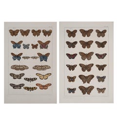
Antique Albertus Seba Pair 18th Century Hand-Colored Engravings Butterfly
By Albertus Seba 1
Located in Washington, DC
Rare pair of original hand-colored prints from Sir Albertus Seba's cabinet of natural curiosities. Prints come from published volumes in Amste...
Category
Antique Mid-18th Century Dutch Prints
Materials
Paper
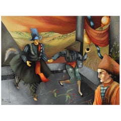
Surreal French Painting "The Black Pearl"
Located in Washington, DC
Exceptionally executed painting, signed lower left corner, titled "La Perle Noire...", dated 1985. Frame is also hand painted by the artist. Measures 13" x 10...
Category
Vintage 1980s French Paintings
Materials
Paper
$1,250 Sale Price
50% Off
Related Items
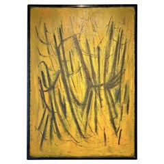
French Abstract Painting from the 1950s
By Hans Hartung
Located in Grenoble, FR
Abstract painting from the 1950s
French work in the style of Hans Hartung
Signature present to identified.
Category
Vintage 1950s French Mid-Century Modern Paintings
Materials
Paint
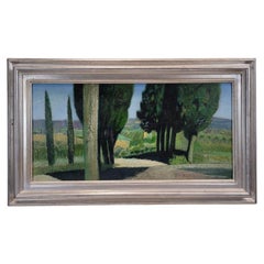
French landscape painting by René Genis green “The alley of the cypresses”
By René Genis
Located in Valladolid, ES
One of a kind and very beautiful work by René Genis, a French painter known for his serene and poetic style, depicts a sown field from an unusual perspective, cut by a foreground of...
Category
Vintage 1950s French Mid-Century Modern Paintings
Materials
Canvas, Wood, Paint
$2,702
H 17.33 in W 29.14 in D 1.97 in
Hand-Colored 18th Century Homann Map of the Danube, Italy, Greece, Croatia
By Johann Baptist Homann
Located in Alamo, CA
"Fluviorum in Europa principis Danubii" is a hand colored map of the region about the Danube river created by Johann Baptist Homann (1663-1724) in his 'Atlas Novus Terrarum', publish...
Category
Antique Early 18th Century German Maps
Materials
Paper
$875
H 20 in W 23.88 in D 0.07 in
18th Century Antique Engraving of the Southern Hemisphere by G. de L'Isle
By Guillaume De L'Isle
Located in Langweer, NL
Antique map titled 'Hemisphere Meridional pour voir plus distinctement Les Terres Australes'. Hemispherical map of the southern hemisphere centered on ...
Category
Antique Late 18th Century Maps
Materials
Paper
$1,158
H 21.58 in W 29.93 in D 0.02 in
French Black + Blue Framed Abstract Painting, 1960s
Located in Chicago, IL
A 1960s French abstract painting that captures the dynamic interplay of texture and color. Layers of black, deep blue, and burnt orange interact with splashes of teal and white, form...
Category
Vintage 1960s French Mid-Century Modern Paintings
Materials
Wood, Paper
"Roses on the Table" Old French Painting, oil on canvas
Located in Alessandria, Piemonte
Delicious painting! Like a bouquet of fresh flowers: for a gift , always..
If You don't want the painting with frame, You can use it for a mirror
ref. O/6796
Category
Antique Late 19th Century French Beaux Arts Paintings
Materials
Canvas
$1,863 Sale Price
20% Off
H 17.72 in W 22.84 in D 1.58 in
Vintage French Framed Oil Painting " The Veiled Woman" 1940's
Located in Douglas Manor, NY
5183 Vintage French painting of a vailed dark haired beauty
Framed in a modernict gilt frame
Image size 19.5x 15.5"
Category
Vintage 1940s Paintings
Materials
Paint
"On the Job, " Watercolor Painting of Black Laborers
Located in Philadelphia, PA
Painted with bravura, this image of shirtless black laborer in the passenger seat of a truck, accompanied by his coworker in a striped t-shirt, is marked by rich, saturated colors an...
Category
Vintage 1930s American Paintings
Materials
Watercolor, Paper
Antique Original Engraving of Chinese Vessels in the 18th Century, 1765
Located in Langweer, NL
Description: Plate no.34: 'Vaisseaux chinois.' (Chinese vessels.) This original auhentic plate originates from: 'Reize rondom de werreld, Gedaan in de jaaren 1740 tot 1744, door den ...
Category
Antique 1760s Prints
Materials
Paper
$260 Sale Price
20% Off
H 10.04 in W 16.07 in D 0 in
The Kingdom of Naples and Southern Italy: A Hand-Colored 18th Century Homann Map
By Johann Baptist Homann
Located in Alamo, CA
"Novissima & exactissimus Totius Regni Neapolis Tabula Presentis Belli Satui Accommo Data" is a hand colored map of southern Italy and the ancient Kingdom of Naples created by Johann...
Category
Antique Early 18th Century German Maps
Materials
Paper
$1,175
H 20 in W 23.88 in D 0.07 in
Antique Hand-Colored Engraving of a Conceptionist Nun, 19th Century
Located in Langweer, NL
Title: Antique Hand-Colored Engraving of a Conceptionist Nun, 19th Century
Description: This finely detailed nineteenth-century hand-colored engraving depicts a Conceptionist nu...
Category
Antique 19th Century Prints
Materials
Paper
18th Century Hand Colored Map of Spain and Portugal by Visscher
By Nicolaes Visscher II
Located in Alamo, CA
This is an early 18th century map of Spain and Portugal, with attractive original hand-coloring, entitled "Hispaniae et Portugalliae Regna per Nicolaum Visscher cum Privilegio Ordinu...
Category
Antique Early 18th Century Dutch Maps
Materials
Paper


