Items Similar to John Ogilby Oxford to Salisbury Road Map #83 Circa 1675
Want more images or videos?
Request additional images or videos from the seller
1 of 8
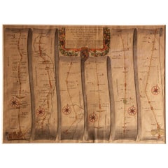
John Ogilby Oxford to Salisbury Road Map #83 Circa 1675
$716
$89520% Off
£543.28
£679.1120% Off
€621.20
€776.5020% Off
CA$1,000.06
CA$1,250.0720% Off
A$1,111.93
A$1,389.9120% Off
CHF 580.59
CHF 725.7320% Off
MX$13,534.87
MX$16,918.5920% Off
NOK 7,408.04
NOK 9,260.0620% Off
SEK 6,940.98
SEK 8,676.2320% Off
DKK 4,636.11
DKK 5,795.1320% Off
Shipping
Retrieving quote...The 1stDibs Promise:
Authenticity Guarantee,
Money-Back Guarantee,
24-Hour Cancellation
About the Item
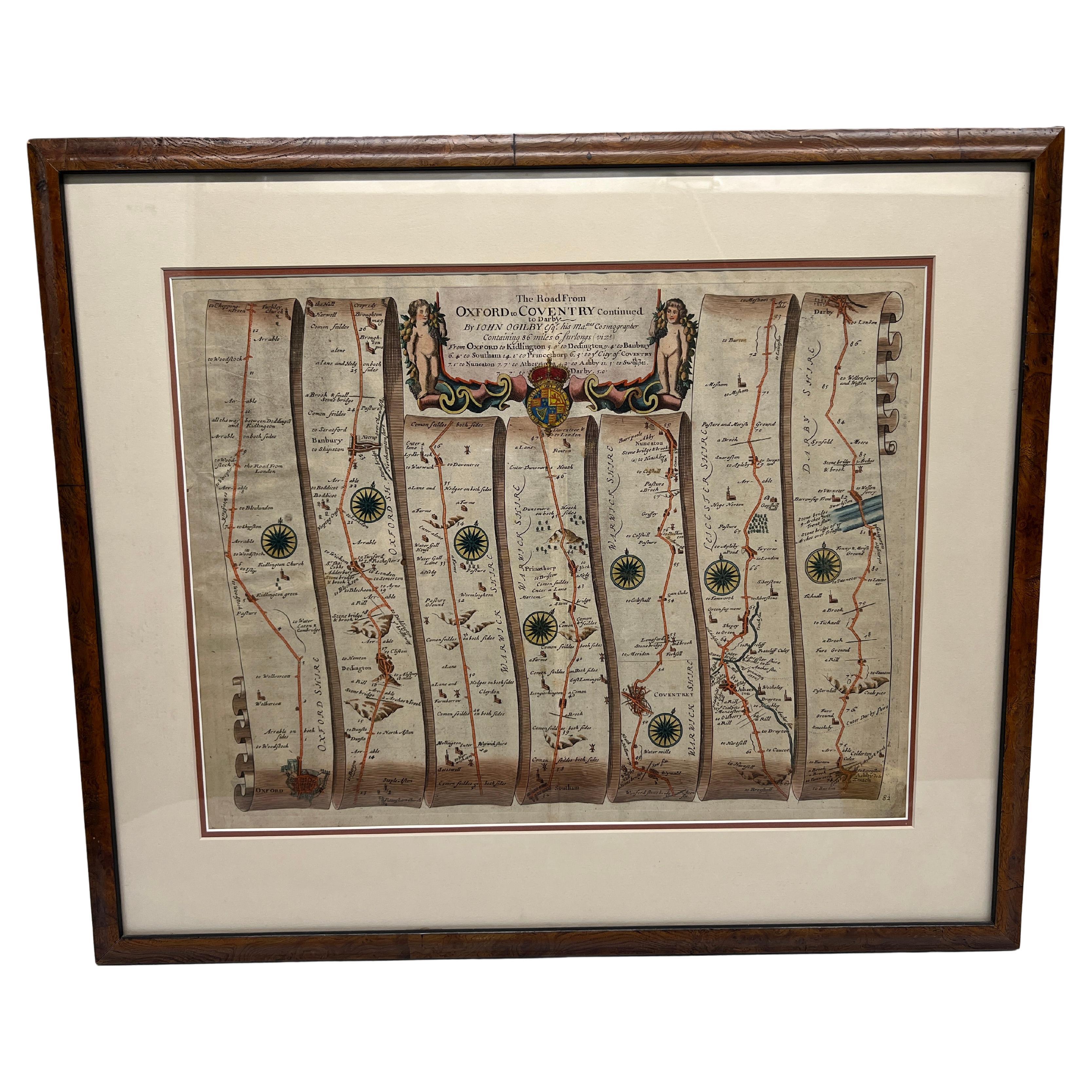
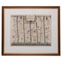
John Ogilby (Scottish, 1600-1676). - Circa 1675
This map is part of his Britannica publication and is #83.
"The road map was first popularised by John Ogilby (1600-1676), Scotsman, dancing master (until his accident), Deputy Master of the Revels, publisher, and cartographer, who published his Britannia in 1675. This showed all the main routes radiating from London, together with a handful of cross-country routes (e.g. York to Lancaster, Carlisle to Tynemouth, Oxford to Cambridge). Like the old Automobile Association personalized route-maps, they are strip maps which concentrate on the roads, orienting the traveller with a compass rose, and showing side roads, landmarks, and the type of terrain, hills to be surmounted and rivers to be crossed. The scale was a standard inch-to-a-mile."
- Creator:John Ogilby (Maker)
- Dimensions:Height: 21 in (53.34 cm)Width: 24.75 in (62.87 cm)Depth: 0.25 in (6.35 mm)
- Style:Regency (In the Style Of)
- Materials and Techniques:
- Place of Origin:
- Period:
- Date of Manufacture:C. 1675
- Condition:Wear consistent with age and use. Minor wear commensurate with age and use.
- Seller Location:Atlanta, GA
- Reference Number:1stDibs: LU7838240398642

About the Seller
5.0
Platinum Seller
Premium sellers with a 4.7+ rating and 24-hour response times
Established in 2012
1stDibs seller since 2022
205 sales on 1stDibs
Typical response time: <1 hour
- ShippingRetrieving quote...Shipping from: Randolph, MA
- Return Policy
Authenticity Guarantee
In the unlikely event there’s an issue with an item’s authenticity, contact us within 1 year for a full refund. DetailsMoney-Back Guarantee
If your item is not as described, is damaged in transit, or does not arrive, contact us within 7 days for a full refund. Details24-Hour Cancellation
You have a 24-hour grace period in which to reconsider your purchase, with no questions asked.Vetted Professional Sellers
Our world-class sellers must adhere to strict standards for service and quality, maintaining the integrity of our listings.Price-Match Guarantee
If you find that a seller listed the same item for a lower price elsewhere, we’ll match it.Trusted Global Delivery
Our best-in-class carrier network provides specialized shipping options worldwide, including custom delivery.More From This Seller
View AllJohn Ogilby Oxford to Salisbury Road Map #82 Circa 1675
By John Ogilby
Located in Atlanta, GA
John Ogilby (Scottish, 1600-1676). - Circa 1675
This map is part of his Britannica publication and is #82.
"The road map was first popularised by John Ogilby (1600-1676), Scotsm...
Category
Antique 17th Century Scottish French Provincial Decorative Art
Materials
Burl
$716 Sale Price
20% Off
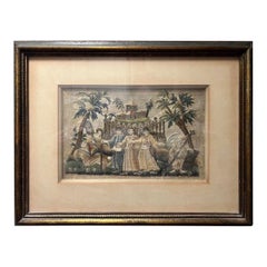
Grand Tour Neoclassical Allegorical Drawing on Paper, 19th Century
Located in Atlanta, GA
This artwork is a finely executed ink drawing with wash, possibly from the late 18th or early 19th century, bearing an inscription that reads, "The letter killeth but the spirit give...
Category
Antique 19th Century Italian Neoclassical Drawings
Materials
Giltwood, Paper
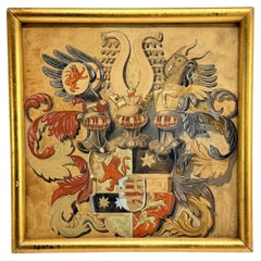
19th C. Heraldic Watercolor of a Composite Noble Achievement, Signed E. Wenzel
Located in Atlanta, GA
A finely rendered heraldic watercolor on paper depicting an elaborate composite coat of arms, signed lower right “E. Wenzel” and likely executed in the late 19th century. The work pr...
Category
Antique 19th Century German Baroque Paintings
Materials
Giltwood, Paint
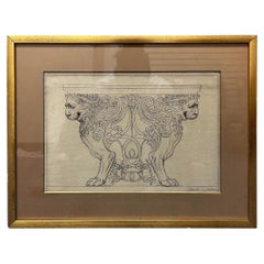
19th Century Italian Grand Tour Era Architectural Drawing on Paper, Framed
Located in Atlanta, GA
An early 18th or 19th century architectural concept drawing of opposing lions with marble top likely as a console table. Marked in early ink to lower r...
Category
Antique 19th Century Drawings
Materials
Paper
$1,440 Sale Price
20% Off
17th Century English Charles II Stumpwork Silk Embroidery 3 Wise Men Panel
Located in Atlanta, GA
An exceptional and early RARE Charles II stumpwork embroidery panel. Cavalier period work of art.
These pieces are incredibly hard to come by and are collected all over the world an...
Category
Antique 17th Century Tapestries
Materials
Silk, Thread, Wood, Paper
$3,916 Sale Price
20% Off
18th Century French Neoclassical Hand-Painted Panel on Canvas
Located in Atlanta, GA
Please note this the painting is dark as original photograph displays.
This exceptional late 18th-century Neoclassical hand-painted panel, crafted on canvas and mounted to a board,...
Category
Antique Late 18th Century French Neoclassical Paintings
Materials
Canvas, Wood, Giltwood, Paint
You May Also Like
Road Map, John Ogilby, London, Barwick, York, Chester, Darlington, Durham Framed
By John Ogilby
Located in BUNGAY, SUFFOLK
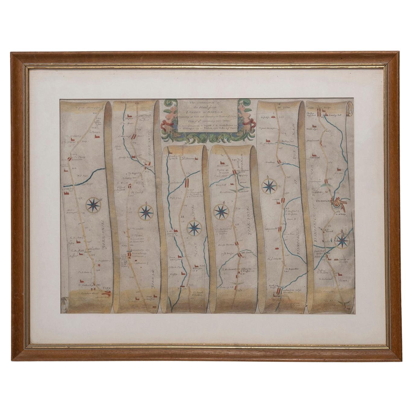
The continuation of the road from London to Barwick beginning at York and extending to Chester in ye Street. Plate ye 4th continuing 76 ½ miles. No 8.
York to Burrowbridge, to Top...
Category
Antique 1670s English Baroque Maps
Materials
Paper

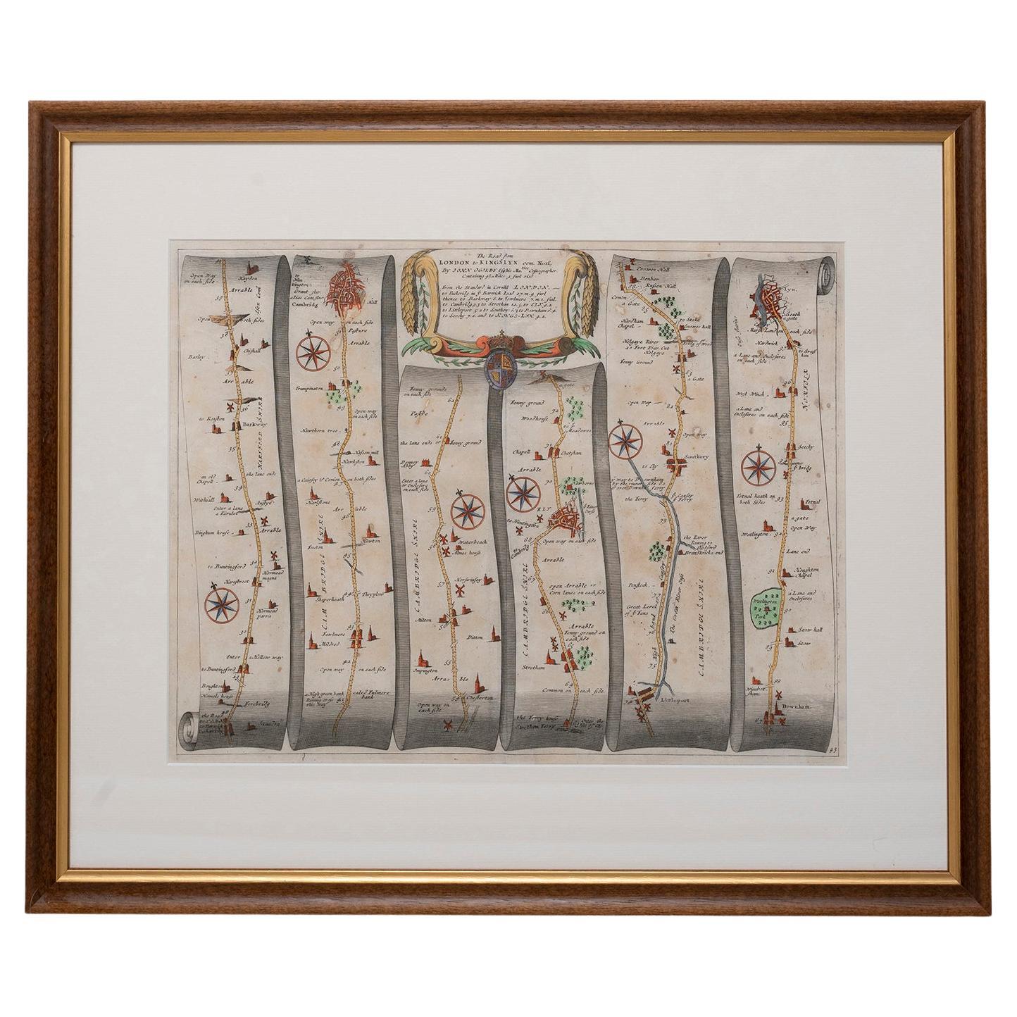
Road Map No43 London to Kings Lynn, Royston to Downham, John Ogilby, Britannia
By John Ogilby
Located in BUNGAY, SUFFOLK
John Ogilby (British 1600-1676) Cosmographer and Geographick Printer to Charles II.
A road map from Britannia, 1675/6. The road from London to Kings Lynn, showing Royston to Downham. In oak and gilded frame.
In a remarkable life John Ogilby pursued, several careers, each ending in misfortune, and yet he always emerged undeterred, to carry on. His modern reputation is based on his final career, started in his sixty-sixth year, as a publisher of maps and geographical accounts.
Ogilby was born outside Dundee, in 1600, the son of a Scottish gentleman...
Category
Antique Late 17th Century British Charles II Maps
Materials
Paper
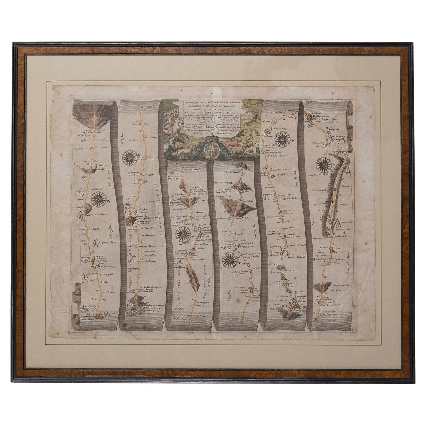
Road Map Britannia No 32 the Road from London to Barnstable John Ogilby Framed
By John Ogilby
Located in BUNGAY, SUFFOLK
A road map from Britannia, by John Ogilby Esq., Cosmographer and Geographick Printer to Charles II. Containing 293 miles. No 32.
From Standard in Cornhill London to Andover thence to Amesbury, to Shruton, to Warminster, to Maiden-Bradley, to Bruton, to Weston, to Ascot and to Bridgewater
Hand coloured, some foxing and creasing, commensurate with age.
Floated in a cream mount with a gilded linear border within a burr walnut, ebonised and gilded frame.
Provenance : purchased as pair from a collector with no 15 London to St Davids. Framed as a pair.
Measures: Black Linear Border around Map Length 44cm., 17 1/8" Height 36cm., 14".
Full Sheet Length 51cm., 20" Height 39cm., 15 1/4"
Frame Length 62cm., 24 1/2 " Height 52cm., 20 1/2"
Literature: In a remarkable life John Ogilby pursued, several careers, each ending in misfortune, and yet he always emerged undeterred, to carry on. His modern reputation is based on his final career, started in his sixty-sixth year, as a publisher of maps and geographical accounts.
Ogilby was born outside Dundee, in 1600, the son of a Scottish gentleman. While he was still a child, the family moved to London. When the elder Ogilby was imprisoned for debt, the young John invested his savings in a lottery, won a minor prize, and settled his father's debts. Unfortunately, not enough money was left to secure John a good apprenticeship; instead, he was apprenticed to a dance master. Ogilby was soon dancing in masques at court but, one day, while executing a particularly ambitious leap, he landed badly. The accident left him with a permanent limp, and ended his dancing career. However, he had come to the attention of Thomas Wentworth, later Earl of Strafford, Charles I's most senior minister. Ever one to exploit his contacts, Ogilby became a dance instructor in Strafford's household.
When Strafford was sent to Ireland, Ogilby accompanied him as Deputy-Master of the Kings Revels, and then Master of Revels. In Dublin, he built the New Theatre, in St. Werburgh Street, which prospered at first, but the Irish Rebellion, in 1641, cost Ogilby his fortune, which he estimated at £2,000, and almost his life. After brief service as a soldier, he returned to England, survived shipwreck on the way, and arrived back penniless.
On his return, Ogilby turned his attention to the Latin classics, as a translator and publisher. His first faltering attempt, in 1649, was a translation of the works of Virgil, but after his marriage to a wealthy widow the same year, his publishing activities received a considerable boost. One means by which Ogilby financed these volumes was by subscription, securing advance payments from his patrons, in return for including their name and coats-of-arms on the plates of illustrations. Another approach was to secure a patron, preferably in the court circle. Ogilby's first patron was Strafford, who found out too late that all leading ministers are dispensable when Charles I assented to his execution in 1641. As he re-established himself, Ogilby sought a new patron, the King himself.
In 1661, Ogilby was approached to write poetry for Charles II's coronation procession; he later published 'The Relation of His Majesties Entertainment Passing Through the City of London', and a much enlarged edition the following year, which included a Fine set of plates depicting the procession. Royal favour was bestowed in 1674 when John Ogilby received the title of 'His Majesty's Cosmographer and Geographick Printer' with a salary of £13.6s.8d per annum.
In 1665, Ogilby left London to avoid the Plague then ravaging the capital. The following year, in the Great Fire of London, Ogilby claimed that he lost his entire stock of books valued at some £3,000, as well as his shop and house, leaving him worth just £5.
As he sought to restore his fortunes, Ogilby was already looking in new directions. The initial opportunity he seized on was the reconstruction of London's burnt-out centre. He secured appointment as a 'sworn viewer', whose duty was to establish the property boundaries as they existed before the Fire. Ogilby was assisted in the project by his step-grandson, William Morgan...
Category
Antique Late 17th Century English Charles II Maps
Materials
Paper
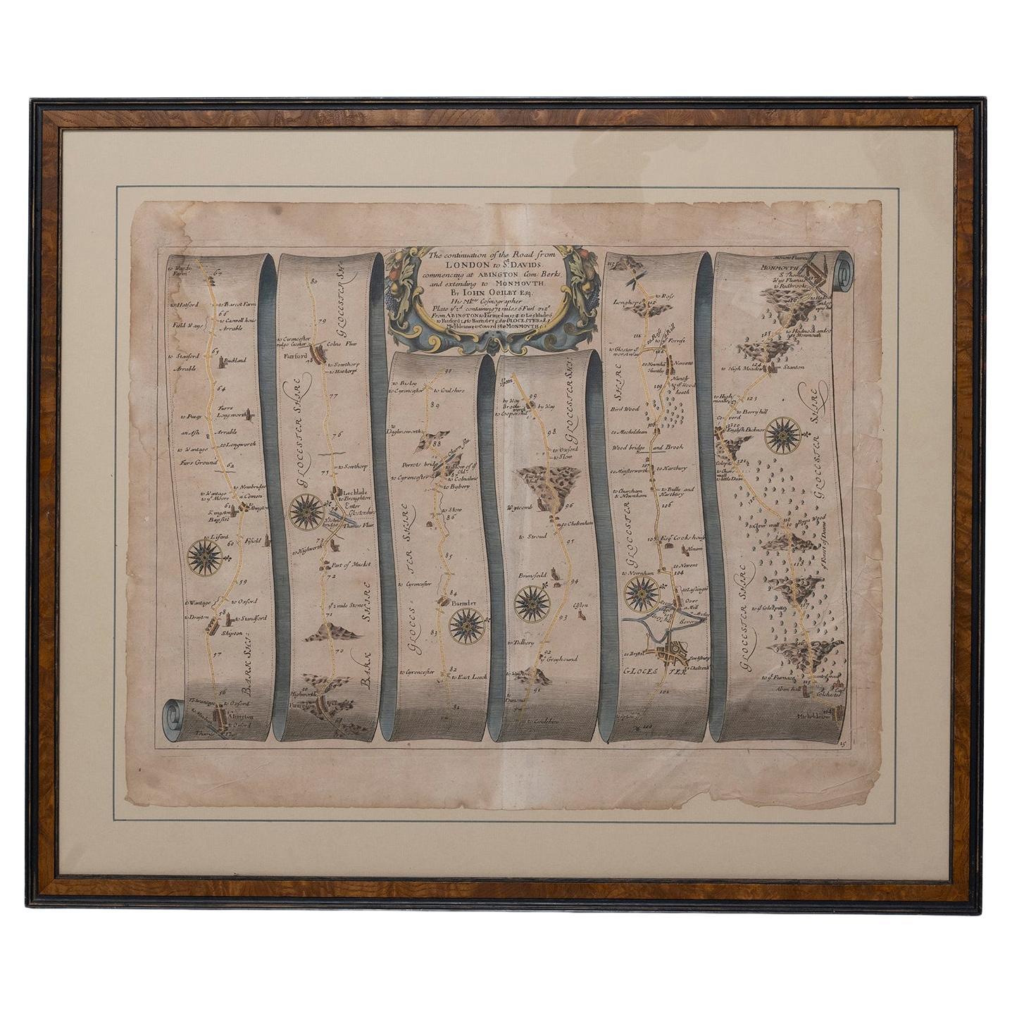
Road Map John Ogilby London St David's Britannia No 15 Abingdon Monmouth Framed
By John Ogilby
Located in BUNGAY, SUFFOLK
John Ogilby (British 1600-1676) Cosmographer and Geographick Printer to Charles II. A road map from Britannia, 1675/6. No 15.
The continuation of the r...
Category
Antique 1670s English Baroque Maps
Materials
Paper
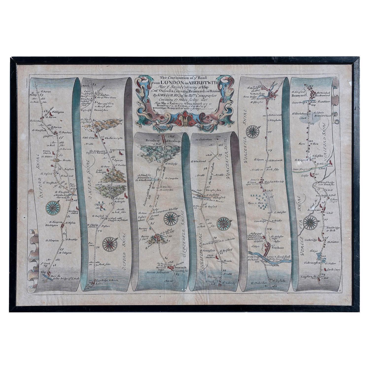
Map Road Strip Britannia Sheet 2 John Ogilby London Aberistwith Islip Bramyard
By John Ogilby
Located in BUNGAY, SUFFOLK
From John Ogilby's, 'Britannia, an Illustration of the Kingdom of
England and Dominion of Wales'. First published in 1675 it remains the greatest advance ...
Category
Antique 17th Century English Baroque Maps
Materials
Paper
Road Map Britannia 1675/6 No 5 Road London to Barwick, London Stilton Grey Frame
By John Ogilby
Located in BUNGAY, SUFFOLK
John Ogilby (British 1600-1676) cosmographer and geographick printer to Charles II.
A road map from Britannia, 1675/6. No 5, The road from London to Barwick: London to Stilton
In a grey painted and gilded frame.
In a remarkable life John Ogilby pursued, several careers, each ending in misfortune, and yet he always emerged undeterred, to carry on. His modern reputation is based on his final career, started in his sixty-sixth year, as a publisher of maps and geographical accounts.
Ogilby was born outside Dundee, in 1600, the son of a Scottish gentleman. While he was still a child, the family moved to London. When the elder Ogilby was imprisoned for debt, the young John invested his savings in a lottery, won a minor prize, and settled his father's debts. Unfortunately, not enough money was left to secure John a good apprenticeship; instead, he was apprenticed to a dance master. Ogilby was soon dancing in masques at court but, one day, while executing a particularly ambitious leap, he landed badly. The accident left him with a permanent limp, and ended his dancing career. However, he had come to the attention of Thomas Wentworth, later Earl of Strafford, Charles I's most senior minister. Ever one to exploit his contacts, Ogilby became a dance instructor in Strafford's household.
When Strafford was sent to Ireland, Ogilby accompanied him as Deputy-Master of the Kings Revels, and then Master of Revels. In Dublin, he built the New Theatre, in St. Werburgh Street, which prospered at first, but the Irish Rebellion, in 1641, cost Ogilby his fortune, which he estimated at £2,000, and almost his life. After brief service as a soldier, he returned to England, survived shipwreck on the way, and arrived back penniless.
On his return, Ogilby turned his attention to the Latin classics, as a translator and publisher. His first faltering attempt, in 1649, was a translation of the works of Virgil, but after his marriage to a wealthy widow the same year, his publishing activities received a considerable boost. One means by which Ogilby financed these volumes was by subscription, securing advance payments from his patrons, in return for including their name and coats-of-arms on the plates of illustrations. Another approach was to secure a patron, preferably in the court circle. Ogilby's first patron was Strafford, who found out too late that all leading ministers are dispensable when Charles I assented to his execution in 1641. As he re-established himself, Ogilby sought a new patron, the King himself.
In 1661, Ogilby was approached to write poetry for Charles II's coronation procession; he later published 'The Relation of His Majesties Entertainment Passing Through the City of London', and a much enlarged edition the following year, which included a Fine set of plates depicting the procession. Royal favour was bestowed in 1674 when John Ogilby received the title of 'His Majesty's Cosmographer and Geographick Printer' with a salary of £13.6s.8d per annum.
In 1665, Ogilby left London to avoid the Plague then ravaging the capital. The following year, in the Great Fire of London, Ogilby claimed that he lost his entire stock of books valued at some £3,000, as well as his shop and house, leaving him worth just £5.
As he sought to restore his fortunes, Ogilby was already looking in new directions. The initial opportunity he seized on was the reconstruction of London's burnt-out centre. He secured appointment as a "sworn viewer", whose duty was to establish the property boundaries as they existed before the Fire. Ogilby was assisted in the project by his step-grandson, William Morgan, and by a number of professional surveyors. The result was an outstanding plan of London, on a scale of 100 feet to an inch, on 20 sheets, although it was not printed until after Ogilby's death.
Ogilby then turned his attention to publishing geographical descriptions of the wider-world. In 1667, he issued 'An Embassy from the East India Company of the United Provinces to the Grand Tartar Cham, Emperor of China.' Buoyed by the response to this volume, Ogilby conceived an ambitious project, a multi-volume description of the world. The volumes were joint collaborations, in conjunction with the Dutch publisher Jacob van Meurs. 'Africa', published in 1670, was the least original of the three, both in terms of the text, maps and illustrations. In a similar vein, he issued the 'Atlas Japannensis' (1670), the 'Atlas Chinensis' (1671), and 'Asia' (1673). In 1671, Ogilby published the 'America', translated from Arnold Montanus' Dutch text. The 'America' is certainly the most original, and most important, of Ogilby's various geographical volumes, and its influence and popularity was immediate.
With its completion, Ogilby turned to a project nearer his heart, the description of Britain. Ogilby originally intended to devote one volume to Britain, but as the project evolved, he became more ambitious, as revealed in a prospectus issued in about 1672:
"This having oblig'd our Author to take new Measures ... to compleat within the space of two Years a Work ... considering the Actual survey of the Kingdom, the Delineation and Dimensuration of the Roads, the Prospects and Ground plots of Cities, with other Ornamentals ... into six fair volumes. The Four first comprehending the historical and geographical description of England, with the County-Maps truly and actually survey'd. ... The fifth containing an Ichnographical and Historical Description of all the Principal Road-ways in England and Wales, in two hundred copper sculptures, after a new and exquisite method. The sixth containing a New and Accurate Description of the famous City of London, with the perfect Ichnography thereof ..."
In the proposals, Ogilby emphasised the scale of the undertaking; no-one before him had attempted such a vast project. He estimated the total costs would be £20,000, a staggering amount. The cost of the complete set of six volumes was to be £34. At that time, Wenceslas Hollar...
Category
Antique Late 17th Century British Charles II Maps
Materials
Paper
More Ways To Browse
17th Century Scottish Furniture
17th Century Scottish
Scottish Regency
Salisbury Antique
Silk Tablecloth
Ancient Helmet
Antique Alligator
Antique Curio Cabinet Furniture
Antique Deer Painting
Antique Egyptian Glass
Antique Gentlemans Cabinet
Antique Glass Elephant
Antique Stamp Press
Antique Swing Sets
Antique Wood Blinds
Antonio Da Ros For Cenedese
Arched Double Doors
Ars Italy