Items Similar to Original Vintage Rail Travel Map Poster France Map SNCF National French Railway

Want more images or videos?
Request additional images or videos from the seller
1 of 5
Original Vintage Rail Travel Map Poster France Map SNCF National French Railway
$1,034.87
£750
€881.56
CA$1,407.50
A$1,577.10
CHF 820.94
MX$19,293.36
NOK 10,420.30
SEK 9,841.85
DKK 6,581
Shipping
Retrieving quote...The 1stDibs Promise:
Authenticity Guarantee,
Money-Back Guarantee,
24-Hour Cancellation
About the Item
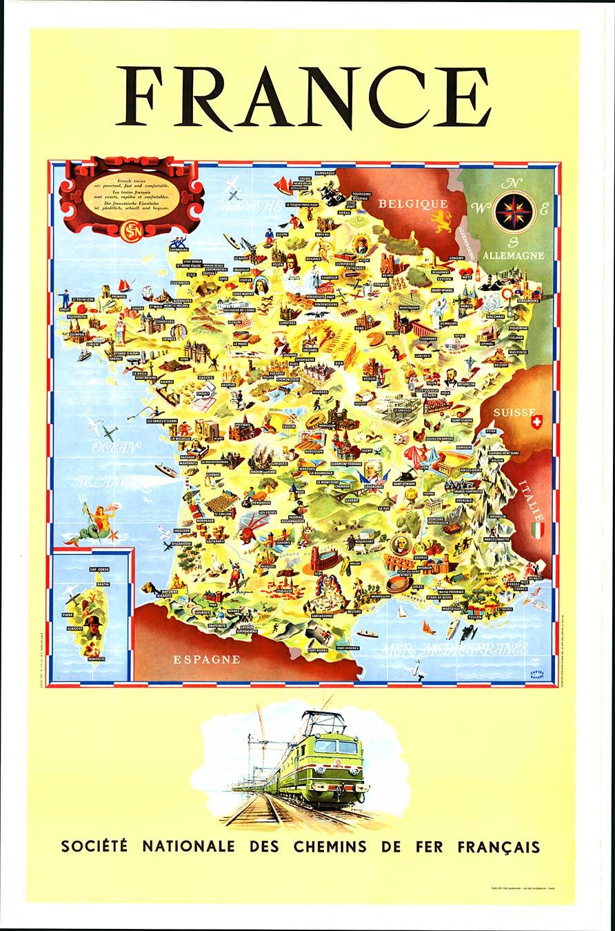
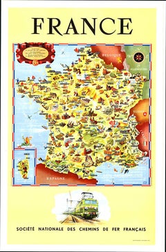
Original vintage rail travel map poster - France Societe Nationale des Chemins de Fer Francais - featuring a colourful illustrated map by Jean Cheval and Alex Batany (as Cheval-Batany) of places of interest and landmarks including ancient and historic buildings, cathedrals and chateaux, notable people including the chemist Louis Pasteur, the soldier and successful military commander Louis-Joseph de Montcalm and the musketeer d'Artagnan, sports and activities including mountain climbing, polo and fishing, rivers and lakes, industry and cattle and wheat farming including rigs and factories, food and drink including cheese, wine and cognac, palm trees, vineyards and orchards, seagulls, planes, a mermaid holding a trident and a conch seashell next to a starfish above an inset for the island of Corsica with an image of Napoleon Bonaparte wearing his bicorne hat, the borders with Belgium / Belgique, Luxembourg, Germany / Allemagne, Switzerland / Suisse, Italy / Italie and Spain / Espagne, sailing boats and ships on the Mediterranean Sea / Mer Mediterranee and Atlantic Ocean Atlantique with the English Channel / Manche next to the decorative SNCF caption above in English, French and German - French trains are punctual, fast and comfortable / Les trains francais sont exacts, rapides et confortable / Die franzosiche Eisenbahn ist punktlich, schnell und bequem - set within a red, white and blue border representing the French flag with a compass point above and artwork by P. Bouvry of an SNCF CC 7001 electric train below. Good condition, creasing, minor staining, tears on edges, paper loss in top right corner.
- Dimensions:Height: 39.38 in (100 cm)Width: 24.41 in (62 cm)Depth: 0.04 in (1 mm)
- Materials and Techniques:
- Place of Origin:
- Period:
- Date of Manufacture:1953
- Condition:Good condition, creasing, minor staining, tears on edges, paper loss in top right corner.
- Seller Location:London, GB
- Reference Number:1stDibs: LU1012639308242
About the Seller
5.0
Platinum Seller
Premium sellers with a 4.7+ rating and 24-hour response times
Established in 2010
1stDibs seller since 2013
571 sales on 1stDibs
Typical response time: <1 hour
Associations
LAPADA - The Association of Arts & Antiques Dealers
- ShippingRetrieving quote...Shipping from: London, United Kingdom
- Return Policy
Authenticity Guarantee
In the unlikely event there’s an issue with an item’s authenticity, contact us within 1 year for a full refund. DetailsMoney-Back Guarantee
If your item is not as described, is damaged in transit, or does not arrive, contact us within 7 days for a full refund. Details24-Hour Cancellation
You have a 24-hour grace period in which to reconsider your purchase, with no questions asked.Vetted Professional Sellers
Our world-class sellers must adhere to strict standards for service and quality, maintaining the integrity of our listings.Price-Match Guarantee
If you find that a seller listed the same item for a lower price elsewhere, we’ll match it.Trusted Global Delivery
Our best-in-class carrier network provides specialized shipping options worldwide, including custom delivery.More From This Seller
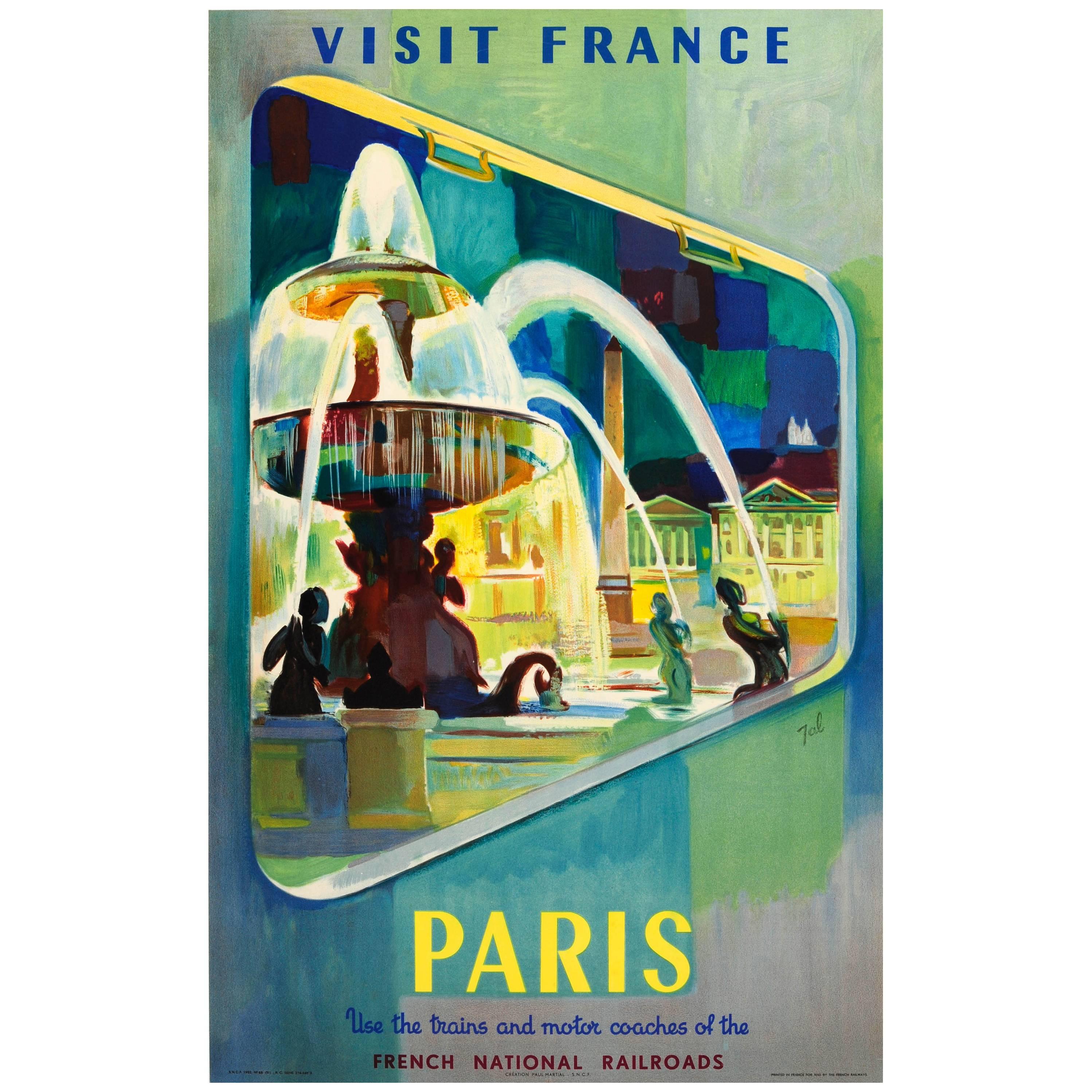
View AllOriginal Vintage SNCF French National Railroads Travel Poster Visit France Paris
Located in London, GB
Original vintage travel advertising poster: Visit France Paris use the trains and motor coaches of the French National Railways (SNCF). Great image featur...
Category
Vintage 1950s French Posters
Materials
Paper

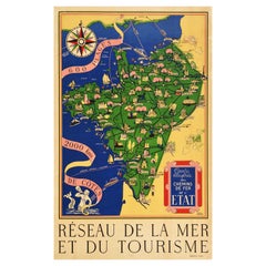
Original Vintage Illustrated Map Poster Railway Travel Normandy Brittany Paris
By Lucien Boucher
Located in London, GB
Original vintage travel poster featuring a colourful Illustrated Map of the State Railways Sea and Tourism Network / Carte Illustre des Chemins de Fer ...
Category
Vintage 1930s French Posters
Materials
Paper
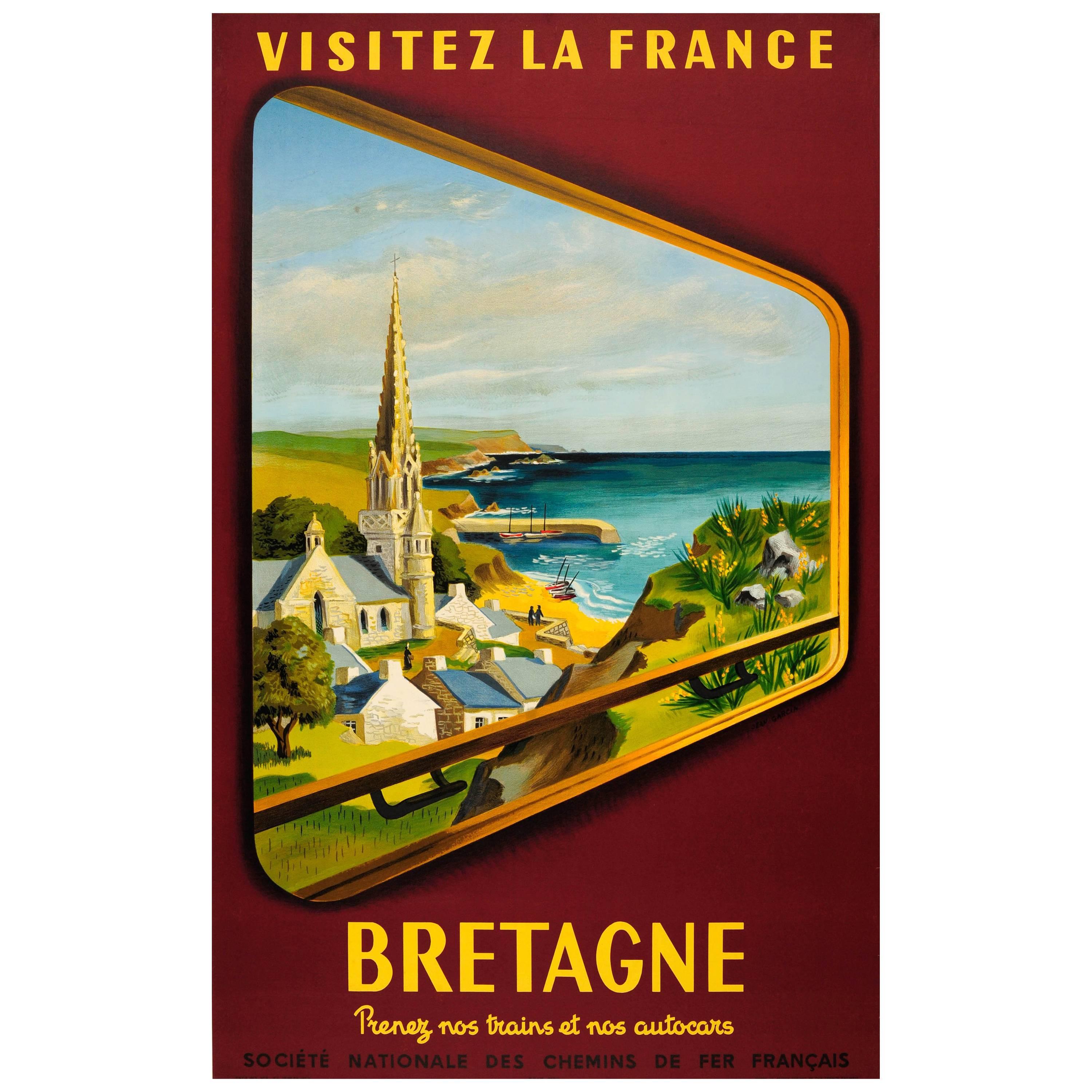
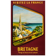
Original Vintage SNCF Railway Travel Poster "Visit France Brittany" by Train
Located in London, GB
Original vintage travel poster: Visit France Brittany – Take our Trains and Coaches / "Visitez la France Bretagne" Prenez nos trains et nos autocars. Grea...
Category
Vintage 1950s French Posters
Materials
Paper
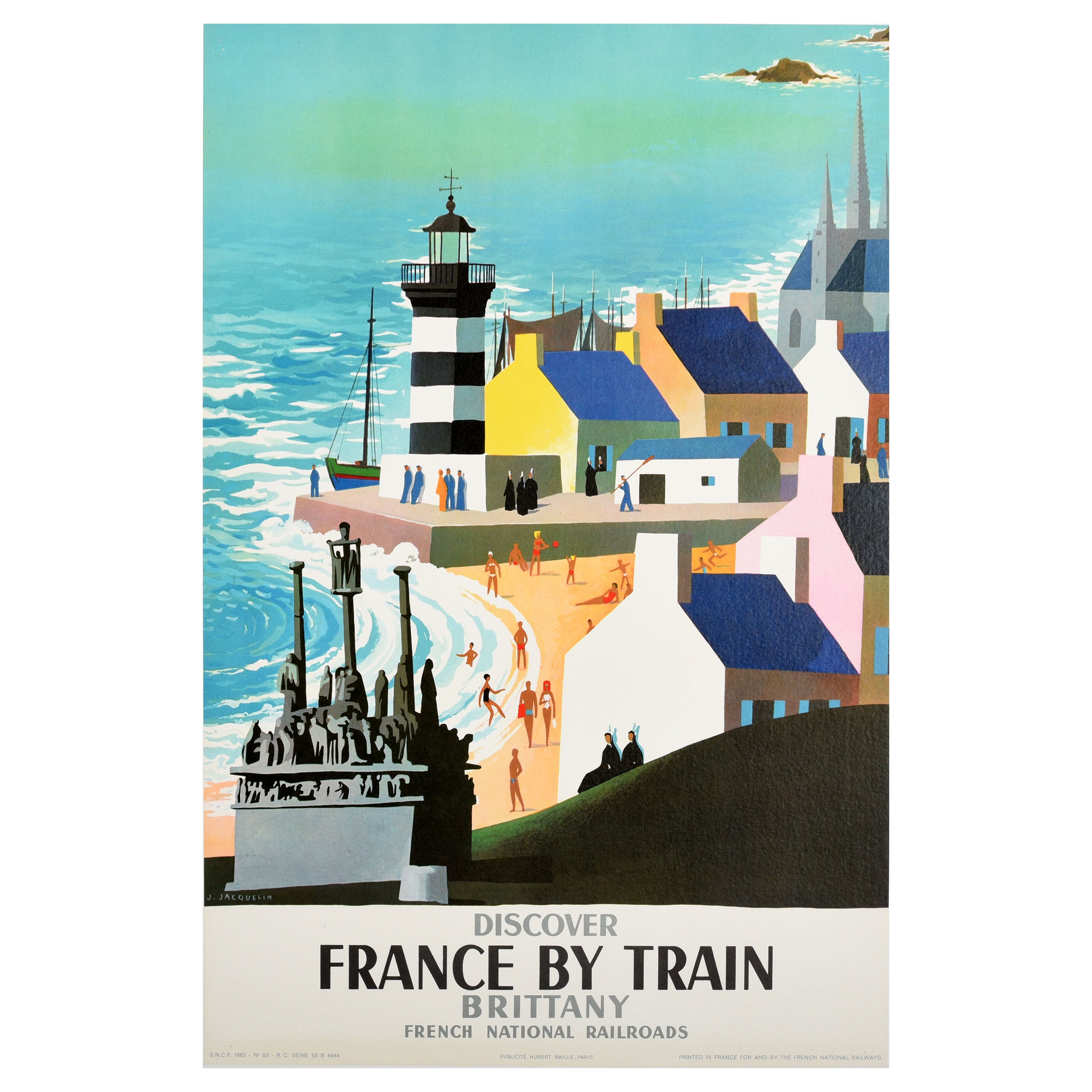
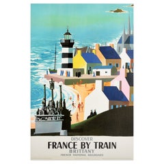
Original Vintage Train Travel Poster Brittany Discover France Mid-Century Modern
Located in London, GB
Original vintage railway travel poster - Discover France By Train Brittany French National Railroads - featuring a colourful view by Jean Jacquelin (190...
Category
Vintage 1960s French Mid-Century Modern Posters
Materials
Paper
Original Vintage Railway Travel PosterBasque Country France SNCF Auguste Durel
Located in London, GB
Original vintage railway travel poster - The Basque Country Discover France by Train French National Railroads - issued by the state owned French railways (SNCF Societe Nationale des...
Category
Vintage 1950s French Posters
Materials
Paper

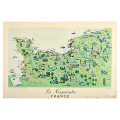
Original Vintage Travel Poster For La Normandie France Normandy Illustrated Map
Located in London, GB
Original vintage travel poster for Normandy - La Normandie France - featuring a pictorial map showing people, historical places of interest, hills and trees, horses, sailing boats and ships at sea on the channel / La Manche...
Category
Vintage 1950s French Posters
Materials
Paper
You May Also Like
Original Societe Nationale des Chemin Map France, 1953 vintage poster on linen
Located in Spokane, WA
Original French vintage travel poster: "FRANCE, Société Nationale des Chemins de Fer Français." Printed in France by the French National Railroads. Original linen-backed poster; read...
Category
1950s American Modern Landscape Prints
Materials
Lithograph
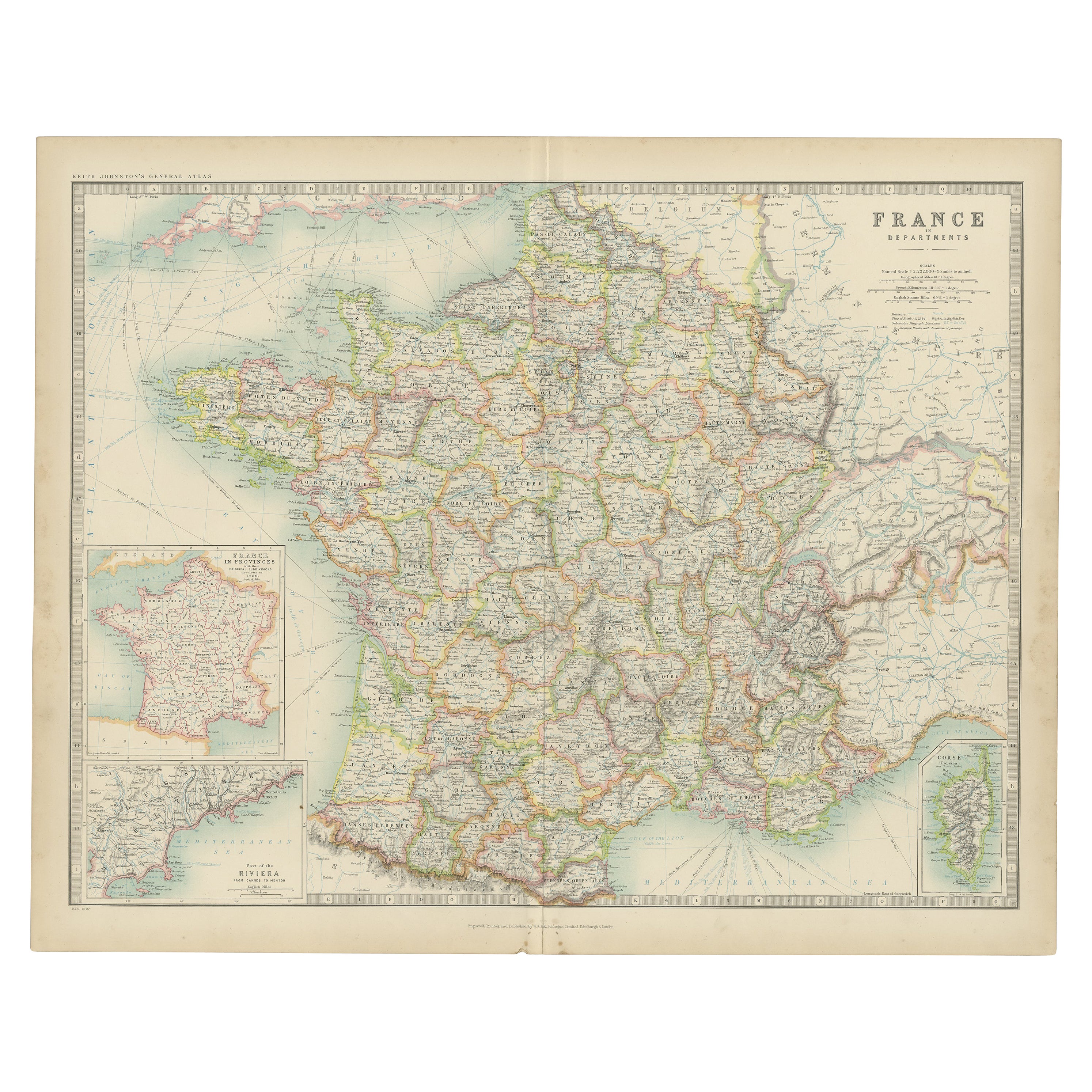
Antique Map of France by Johnston (1909)
Located in Langweer, NL
Antique map titled 'France'. Original antique map of France. With inset maps of France in provinces, part of the Riviera and Corsica. This map or...
Category
Early 20th Century Maps
Materials
Paper

$239 Sale Price
20% Off
Antique Map of France in Provinces, with Inset of Paris
Located in Langweer, NL
Antique map titled 'France par Provinces'. Original antique map of France in Provinces. It covers from the Flanders in the north to Roussillon in the south and from Brittany in the w...
Category
Antique Mid-19th Century Maps
Materials
Paper
$105 Sale Price
20% Off
Large Vintage France Map, Continental, Historical Cartography, Late 20th Century
Located in Hele, Devon, GB
This is a large vintage map of France. A Continental, framed example of historical cartography, dating to the late 20th century, circa 1970.
Fas...
Category
Late 20th Century European Mid-Century Modern Prints
Materials
Glass, Wood, Paper

Large Antique Map of France with Original Hand Coloring
Located in Langweer, NL
Antique map titled 'France in Provinces'. Beautiful antique map of France. Drawn and engraved for John Thomson's 'New General Atlas' published circa 1814.
Category
Antique Early 19th Century Maps
Materials
Paper
$421 Sale Price
20% Off
Vintage Mural Rollable Map Wall Chart France Benelux Countries South England
Located in Berghuelen, DE
A cottagecore pull-down wall chart map illustrating France and the Benelux countries (the Netherlands, Belgium and Luxemburg) and main parts of Western Europe. Published by Justus Pe...
Category
Mid-20th Century German Country Prints
Materials
Canvas, Wood, Paper
More Ways To Browse
Italy Flag Vintage
Ship Mermaid
Louis Cognac
Swiss Cheese
Louis Pasteur
Military Compass
Vintage Movie Posters Clint Eastwood
Vintage Pull Down Anatomy Chart
Vintage Scifi Movie Posters
Vintage Scuba Poster
Vivre Sa Vie
Who Framed Roger Rabbit
Winona Ryder
Zeppelin Poster
1999 Yves Saint Laurent Love Poster
Air India Maharaja
Andy Warhol Perfume Bottle
Arnold Schwarzenegger Vintage Poster