Items Similar to Old Engraving of French Visiting Tomari, a Village in Far East Russia, 1797

Want more images or videos?
Request additional images or videos from the seller
1 of 5
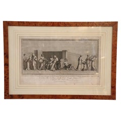
Old Engraving of French Visiting Tomari, a Village in Far East Russia, 1797
$321.36
$401.6920% Off
£240.88
£301.0920% Off
€272
€34020% Off
CA$441.49
CA$551.8620% Off
A$492.88
A$616.1020% Off
CHF 258.26
CHF 322.8320% Off
MX$6,033.32
MX$7,541.6520% Off
NOK 3,279.92
NOK 4,099.9020% Off
SEK 3,092.55
SEK 3,865.6820% Off
DKK 2,070.56
DKK 2,588.2020% Off
About the Item
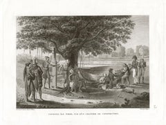
Plate: 'Costumes des Habitants de la Baie de Langle.' (Costumes of the inhabitants of Langle Bay, Russia).
Tomari (Russian: ??????) is a coastal town and the administrative center of Tomarinsky District in Sakhalin Oblast, Russia, located on the western coast of the Sakhalin Island, 167 kilometers (104 mi) northwest of Yuzhno-Sakhalinsk, the administrative center of the oblast. As of the 2010 Census, its population was 4,541.
The bay on which Tomari now stands was visited between July 12 and 14, 1787 by two French frigates, Boussole and Astrolabe, commanded by Lapérouse. The French named it Langle Bay after the captain of the Astrolabe. At that time, it was no more than a small cluster of huts. The French had good relations with the local people who they considered to be in the very distant past of northern Chinese origin, describing them as intelligent, good-looking, and short in stature. The locals were engaged primarily in fishing, hunting, and herding, with hardly any agriculture. They traded regularly with the communities on the Amur River on the mainland and with Japan. Lapérouse gives a very detailed description of his relations with these people in his work Voyage de Laperouse Autour du Monde, published in 1797.
After the design by Count de Vancy, engraved by Cathelin.
This attractive original old antique print / plate originates from: 'Atlas du Voyage de la Pérouse' (no.50).
- Dimensions:Height: 11.62 in (29.5 cm)Width: 16.93 in (43 cm)Depth: 0 in (0.02 mm)
- Materials and Techniques:Paper,Engraved
- Period:1790-1799
- Date of Manufacture:1797
- Condition:Repaired: small creases around the edges have been backed with tape on the backside. Wear consistent with age and use. General age related toning and creases with repairs. A few small remains of tape on the back side. Nevertheless a very interesting print with lots of details. Please study scan carefully.
- Seller Location:Langweer, NL
- Reference Number:Seller: BG-13205-11stDibs: LU3054328464342
About the Seller
5.0
Recognized Seller
These prestigious sellers are industry leaders and represent the highest echelon for item quality and design.
Platinum Seller
Premium sellers with a 4.7+ rating and 24-hour response times
Established in 2009
1stDibs seller since 2017
2,513 sales on 1stDibs
Typical response time: <1 hour
- ShippingRetrieving quote...Shipping from: Langweer, Netherlands
- Return Policy
Authenticity Guarantee
In the unlikely event there’s an issue with an item’s authenticity, contact us within 1 year for a full refund. DetailsMoney-Back Guarantee
If your item is not as described, is damaged in transit, or does not arrive, contact us within 7 days for a full refund. Details24-Hour Cancellation
You have a 24-hour grace period in which to reconsider your purchase, with no questions asked.Vetted Professional Sellers
Our world-class sellers must adhere to strict standards for service and quality, maintaining the integrity of our listings.Price-Match Guarantee
If you find that a seller listed the same item for a lower price elsewhere, we’ll match it.Trusted Global Delivery
Our best-in-class carrier network provides specialized shipping options worldwide, including custom delivery.More From This Seller
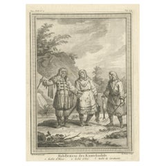
View AllCopper Engraving of Kamchadal Men from Kamchatka, Russia, 1770
Located in Langweer, NL
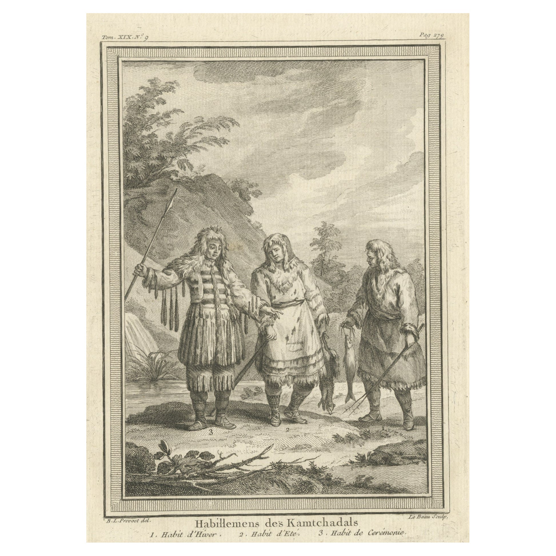
Description: Antique print titled 'Habillemens des Kamtchadals'. Copper engraving of Kamchadal men. This print originates from volume 19 of 'Histoire generale des voyages (..)' by Antoine Francois Prevost d'Exile.
Artists and Engravers: Published by Panckoucke.
The Kamchadals inhabit Kamchatka, Russia. The name "Kamchadal" was applied to the descendants of the local Siberians and aboriginal peoples (the Itelmens, Ainu, Koryaks and Chuvans) who assimilated with the Russians. The descendants of the mixed-blood Russian settlers in 18th-19th century are called Kamchadals these days. The Kamchadals speak Russian with a touch of local dialects of the aboriginal languages of Kamchatka. The Kamchadals engage in fur trading...
Category
Antique 1770s Prints
Materials
Paper
$321 Sale Price
20% Off
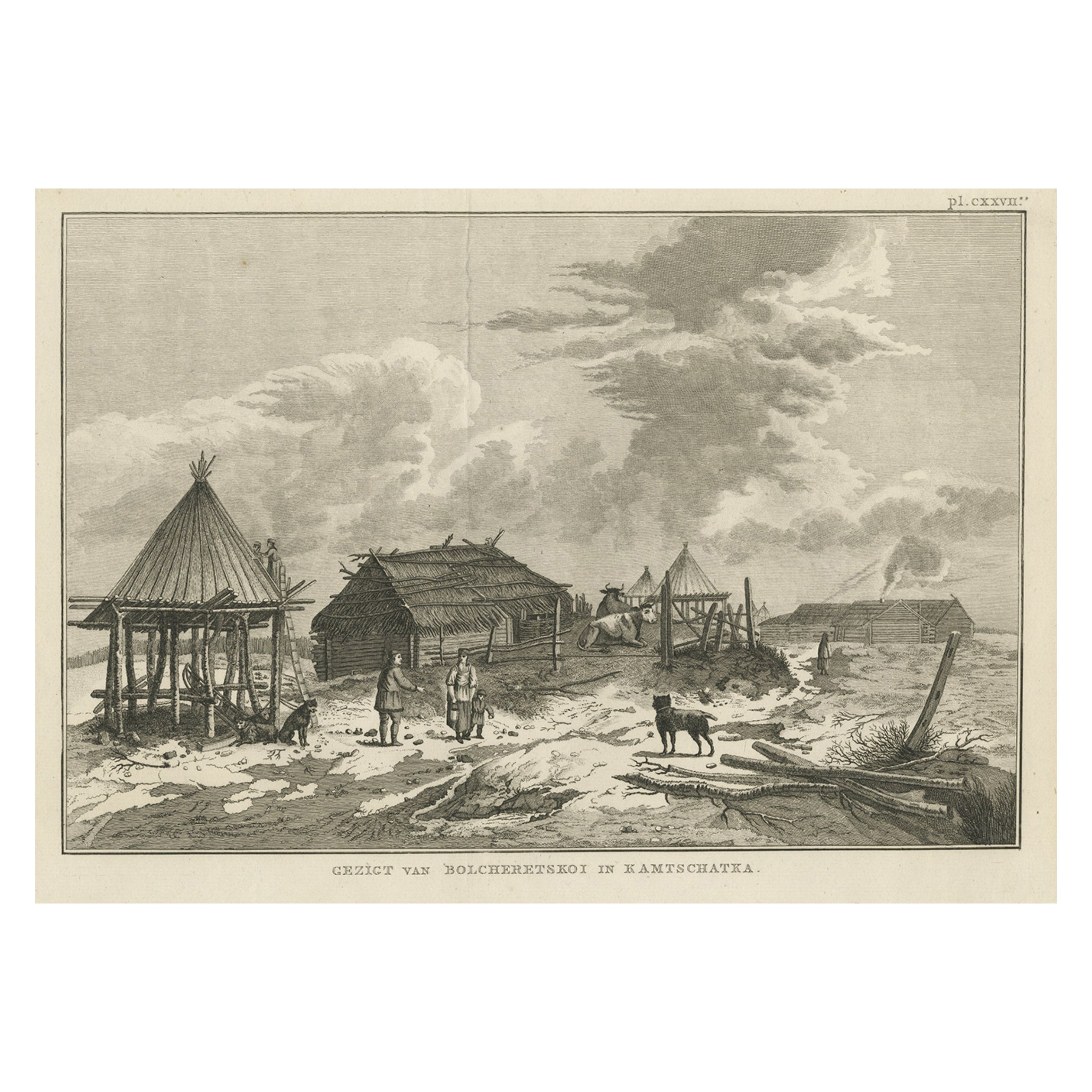
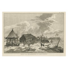
Antique Print of Bolcheretskoi in Kamchatka, Russia, 1803
By James Cook
Located in Langweer, NL
Antique print titled 'Gezigt van Bolcheretskoi in Kamtschatka'. Antique view of Bolcheretskoi in Kamchatka. Originates from 'Reizen Rondom de Waereld door James Cook (..)'.
Artis...
Category
Antique 19th Century Prints
Materials
Paper
$311 Sale Price
20% Off
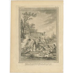
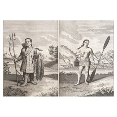
Antique Print of Kamchadal People Preparing Fish in Russia, 1770
Located in Langweer, NL
Antique print titled 'Maniére dont les Kamtchadals sons sécher le Poisson (..)'. Copper engraving of Kamchadal people preparing fish. This print originates from volume 19 of 'Histoir...
Category
Antique 18th Century Prints
Materials
Paper
$170 Sale Price
20% Off
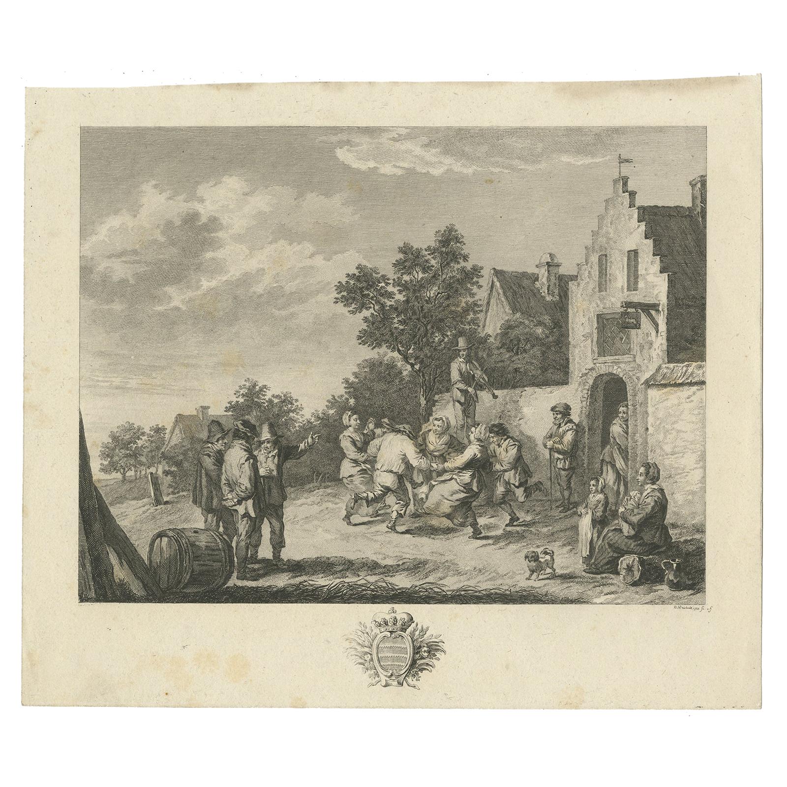
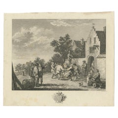
Antique Print of a Village Scene by Weisbrod, circa 1800
Located in Langweer, NL
Village scene by Carl Wilhelm Weisbrod made after David Teniers II.
Category
Antique Early 19th Century Prints
Materials
Paper
$94 Sale Price
20% Off
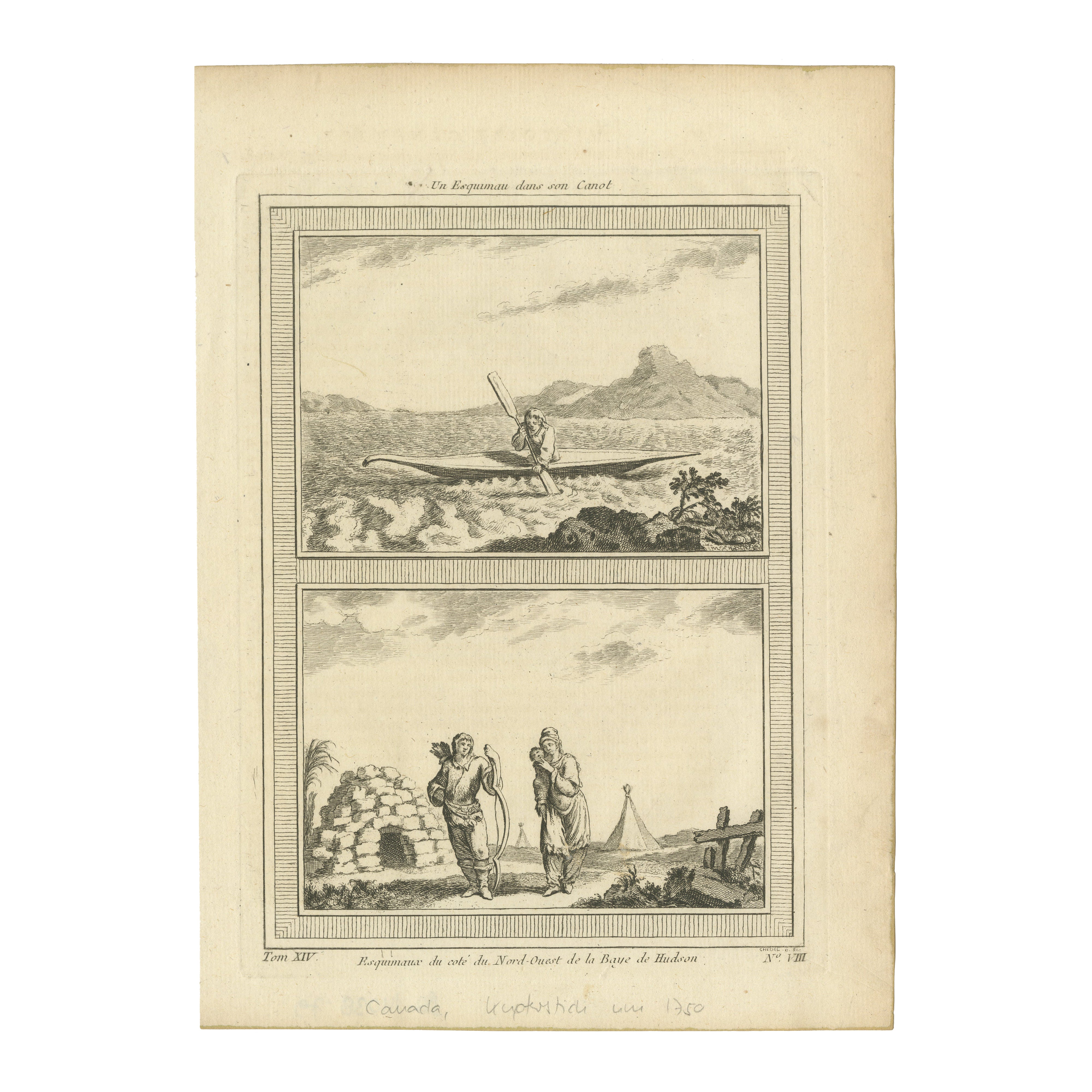
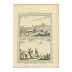
1757 Engraving of Inuit & Indigenous Peoples – Hudson Bay & Arctic Canoe Scene
Located in Langweer, NL
Title: 1757 Engraving of Inuit & Indigenous Peoples – Hudson Bay & Arctic Canoe Scene
Description: This rare 1757 antique copperplate engraving presents two fascinating scenes depicting Indigenous life in Arctic Canada, focusing on the Inuit and other First Nations communities in the Hudson Bay region. Originally published in *Histoire Générale des Voyages*, the engraving provides an invaluable visual record of daily life, survival techniques, and traditional dwellings.
The top illustration, titled 'Un Esquimau dans son Canot', depicts an Inuit paddling a sleek, narrow kayak through choppy waters, showcasing the remarkable boat-making skills of the Arctic peoples. The kayak, designed for hunting and efficient travel, is shown in its traditional form, reflecting centuries of adaptation to harsh northern environments.
The bottom illustration, 'Esquimaux du côté du Nord-Ouest de la Baie de Hudson', portrays a male and female Inuit figure standing near an igloo, a crucial form of temporary winter shelter. The man holds a bow and arrows, symbolizing subsistence hunting, while the woman carries a small child. In the background, additional Indigenous dwellings, including conical tipis, suggest the presence of other First Nations groups living near the Hudson Bay coastline.
The detailed hatching and shading techniques used in the engraving bring out the textures of clothing, landscapes, and architectural features, making this a historically and artistically significant piece. As an early European representation of Arctic Indigenous culture, it holds great value for collectors of ethnographic art, Canadian history, and antique travel prints...
Category
Antique 1750s Prints
Materials
Paper
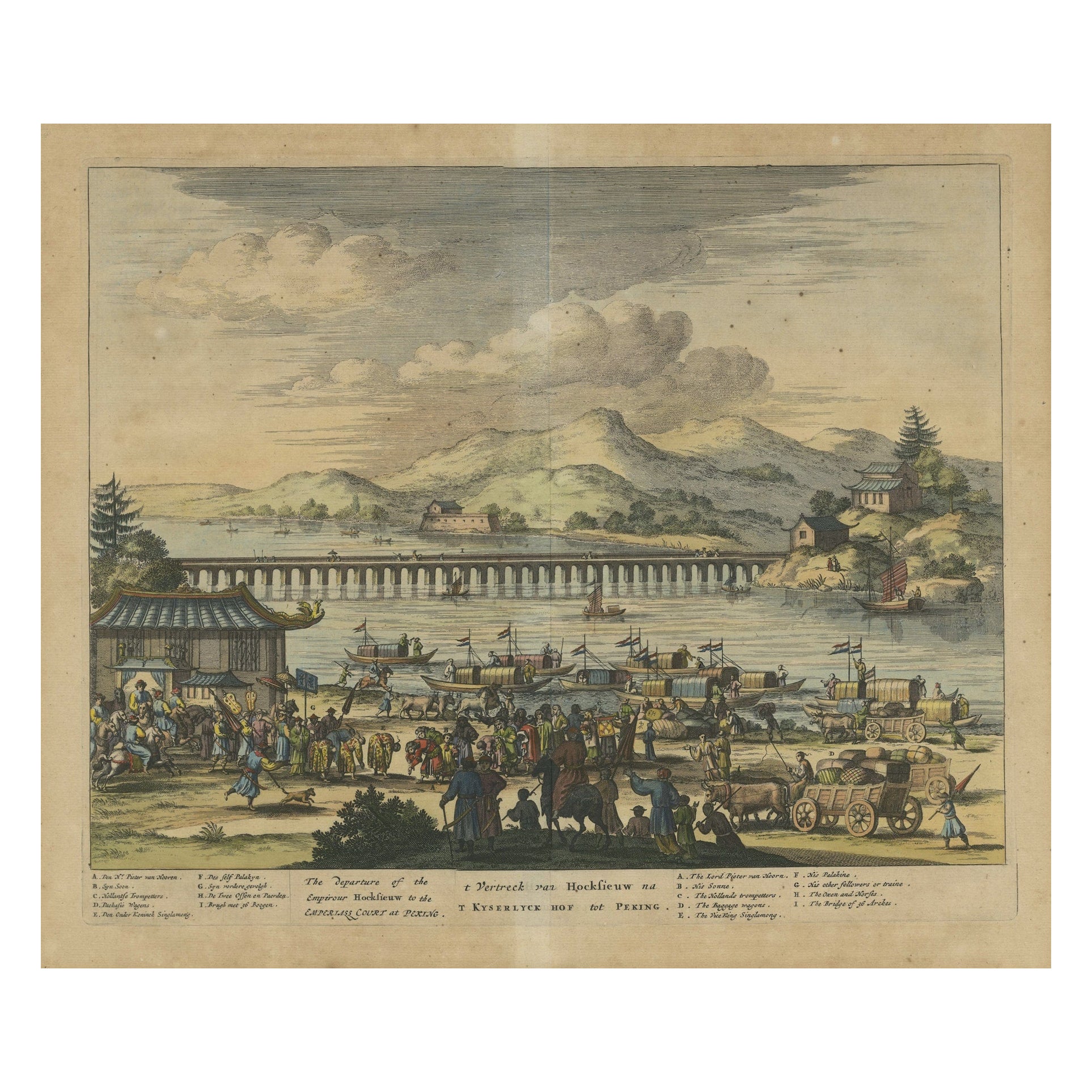
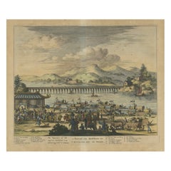
Original Copper Engraving Depicting Dutch Merchants visting China, ca.1700
Located in Langweer, NL
Title: 'The departure of the Empirour Hockflieuw to the Emprial Court at Peking' with further description in Dutch.
The Dutch man Pieter van Hoorn, his son...
Category
Antique Early 1700s Prints
Materials
Paper
$226 Sale Price
20% Off
You May Also Like
Original Antique Ethnographical Print of Indigenous Siberians. C.1780
Located in St Annes, Lancashire
Wonderful print of indigenous Siberians
Copper-plate engraving
Published C.1780
Unframed.
Category
Antique 1780s English Georgian Prints
Materials
Paper
Coupang : Ile Timor. Vue d'un chantier de construction. Early C19th engraving
Located in Melbourne, Victoria
'Coupang : Ile Timor. Vue d'un chantier de construction'
Depicts Timorese people and Europeans building a rowboat under a tree, with other boats in the distance. The work is being overseen by a senior naval man, possibly intended to be Captain Freycinet.
Steel-engraving by Friedrich Schroeder (1768-1839) after F Garnier after Alphonse Pellion. Alphonse Pellion, artist and naval draughtsman, was a midshipman aboard l'Uranie on Louis de Freycinet's three-year scientific and ethnographic expedition around the world in 1817-1820.
From Louis Freycinet's 'Voyage Autour du Monde, Entrepris par Ordre du Roi ... Execue sur les Corvettes de S. M. l'Uranie et la Physicienne Pendant les Annees 1817, 1818, 1819 et 1820', published in Paris in 1825.
Louis Claude de Saulces de Freycinet (1779-1842) joined the French Navy in 1793 and was a veteran of the Baudin's voyage of discovery (1801-1803). He also completed the narrative of the expedition which appeared under the title of 'Voyage de Decouvertes aux Terres Australes'. In 1817 de Freycinet successfully lobbied the Government and King Louis XVIII agreed to support a new global campaign. Its mission was to finally determine the shape of the earth and return with detailed reports on geography, people, government, commerce and art of this new world. The 350-ton corvette Uranie had a complement of 120 men and 23 officers including the artist Jacques Arago and a priest. Over the next three years Uranie visited Australia, East Timor...
Category
Early 19th Century Victorian Landscape Prints
Materials
Engraving
St. Laurent - Original Lithograph by N. Toussaint Charlet - Early 19th Century
Located in Roma, IT
Le Fort St. Laurent is an original artwork realized by Nicolas Toussaint Charlet (1792-1845). Lithograph print. Signed on plate on the lower center. Titled "Le Fort St. Laurent". Edi...
Category
Early 19th Century Modern Figurative Prints
Materials
Lithograph
Antique Lithograph by François Boucher "Vue des Environs de Beauvais" - 2Y169
Located in Bordeaux, FR
This antique lithograph by François Boucher, titled "Vue des Environs de Beauvais," offers a glimpse into the picturesque landscapes of Beauvais as envisioned by the renowned 18th-ce...
Category
Antique 18th Century French Empire Antiquities
Materials
Paper
$200 Sale Price
50% Off
The First of September "Morning" Engraving, 1799
Located in Carmel, CA
Mezzotint engraving, 1799, The First of September, after painting by George Moreland. Moreland was a noted London landscape and genre painter. By the...
Category
Antique 1790s English Georgian Prints
Materials
Paper
18th Century Antique Etching Print by Alessandro Mochetti
Located in Casale Monferrato, IT
Beautiful 18th century antique etching print with in walnut briar frame. Was etching by Alessandro Mochetti (1760 - 1812) was an Italian engrave...
Category
Antique 1780s Italian Prints
Materials
Paper
$1,701 Sale Price
20% Off
More Ways To Browse
Dragon Horn
Empire Secretary Mahogany
Father Time Clock
Fish Lighter
Fisherman Porcelain
Fremiet Emmanuel
French Portico Clock
Georg Jensen Large Bowl
Glass Smoking Accessories
Gold Carriage Clock
Gold Gilt Hand Painted Round Table
Gothic Hardware
Gothic Window Frame
H P Vintage Furniture Company
King Size Louis Bed
Louis Xvi Drop Front
Murano Red Fish
Nouvel Glass