Items Similar to Original Antique Engraving of Algiers in Algeria, 1773


Want more images or videos?
Request additional images or videos from the seller
1 of 7
Original Antique Engraving of Algiers in Algeria, 1773
$470.08
$587.6020% Off
£349.69
£437.1120% Off
€392
€49020% Off
CA$643.70
CA$804.6220% Off
A$715.70
A$894.6320% Off
CHF 373.70
CHF 467.1320% Off
MX$8,711.86
MX$10,889.8320% Off
NOK 4,768.27
NOK 5,960.3320% Off
SEK 4,467.64
SEK 5,584.5520% Off
DKK 2,984.08
DKK 3,730.1020% Off
Shipping
Retrieving quote...The 1stDibs Promise:
Authenticity Guarantee,
Money-Back Guarantee,
24-Hour Cancellation
About the Item
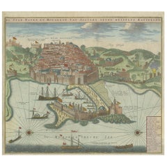
Antique print titled 'Algiers'. Old print with a view of Algiers, Algeria. With Dutch legend. Originates from the first Dutch editon of an interesting travel account of Northern Africa titled 'Reizen en Aanmerkingen door en over Barbaryen en het Ooste'.
Artists and Engravers: Author: T. Shaw. Translated by P. Boddaert and published by J. van Schoonhoven.
Condition: Very good, general age-related toning. Please study image carefully.
Date: 1773
Overall size: 41 x 26.5 cm.
Image size: 24.5 x 19 cm.
We sell original antique maps to collectors, historians, educators and interior decorators all over the world. Our collection includes a wide range of authentic antique maps from the 16th to the 20th centuries. Buying and collecting antique maps is a tradition that goes back hundreds of years. Antique maps have proved a richly rewarding investment over the past decade, thanks to a growing appreciation of their unique historical appeal. Today the decorative qualities of antique maps are widely recognized by interior designers who appreciate their beauty and design flexibility. Depending on the individual map, presentation, and context, a rare or antique map can be modern, traditional, abstract, figurative, serious or whimsical.
- Dimensions:Height: 10.44 in (26.5 cm)Width: 16.15 in (41 cm)Depth: 0 in (0.01 mm)
- Materials and Techniques:
- Period:
- Date of Manufacture:1773
- Condition:Condition: Very good, general age-related toning. Please study image carefully.
- Seller Location:Langweer, NL
- Reference Number:Seller: BG-11797-231stDibs: LU3054329302872
About the Seller
5.0
Recognized Seller
These prestigious sellers are industry leaders and represent the highest echelon for item quality and design.
Platinum Seller
Premium sellers with a 4.7+ rating and 24-hour response times
Established in 2009
1stDibs seller since 2017
2,510 sales on 1stDibs
Typical response time: <1 hour
- ShippingRetrieving quote...Shipping from: Langweer, Netherlands
- Return Policy
Authenticity Guarantee
In the unlikely event there’s an issue with an item’s authenticity, contact us within 1 year for a full refund. DetailsMoney-Back Guarantee
If your item is not as described, is damaged in transit, or does not arrive, contact us within 7 days for a full refund. Details24-Hour Cancellation
You have a 24-hour grace period in which to reconsider your purchase, with no questions asked.Vetted Professional Sellers
Our world-class sellers must adhere to strict standards for service and quality, maintaining the integrity of our listings.Price-Match Guarantee
If you find that a seller listed the same item for a lower price elsewhere, we’ll match it.Trusted Global Delivery
Our best-in-class carrier network provides specialized shipping options worldwide, including custom delivery.More From This Seller
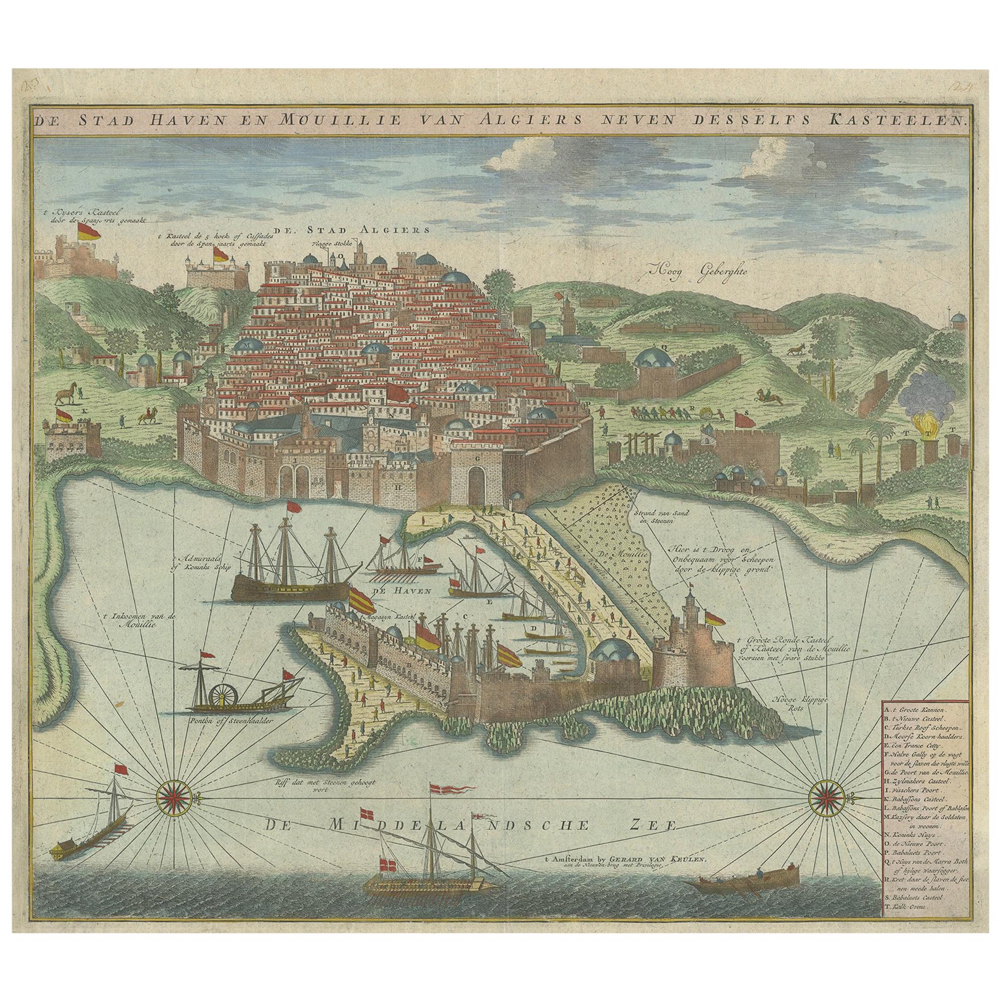
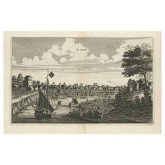
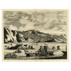
View AllAntique Print of the Port and City of Algiers by Van Keulen, circa 1720
Located in Langweer, NL
Antique print titled 'De Stad Haven en Mouillie van Algiers neven desselfs Kastelen'. Rare double-page bird's-eye view of the port and city of Algiers. With detailed key in the lower right corner. Published by G. van Keulen...
Category
Antique Early 18th Century Prints
Materials
Paper
$1,439 Sale Price
20% Off
Antique Copper Engraving of the City of Kuchin in China, 1668
By Johannes Nieuhof
Located in Langweer, NL
Antique print China titled 'Kuching'.
Old print depicting a view on the Chinese city of Kuching or Kuchin (Gui Jiang, Kuei Chiang), near the river Gui (Guei). This area is close ...
Category
Antique 17th Century Prints
Materials
Paper
$326 Sale Price
20% Off
Antique Print of the City of Japha 'Jaffa, Israel' by N. Sanson, 1709
Located in Langweer, NL
Antique print titled 'Joppe; in 't Hebreeusch by ouds Japho; hedendaags Japha of Jaffa; volgens d'aftekening gedan 1668.' This print was published in 1709 by N. Sanson.
Category
Antique Early 18th Century Prints
Materials
Paper
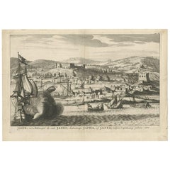
$345 Sale Price
20% Off
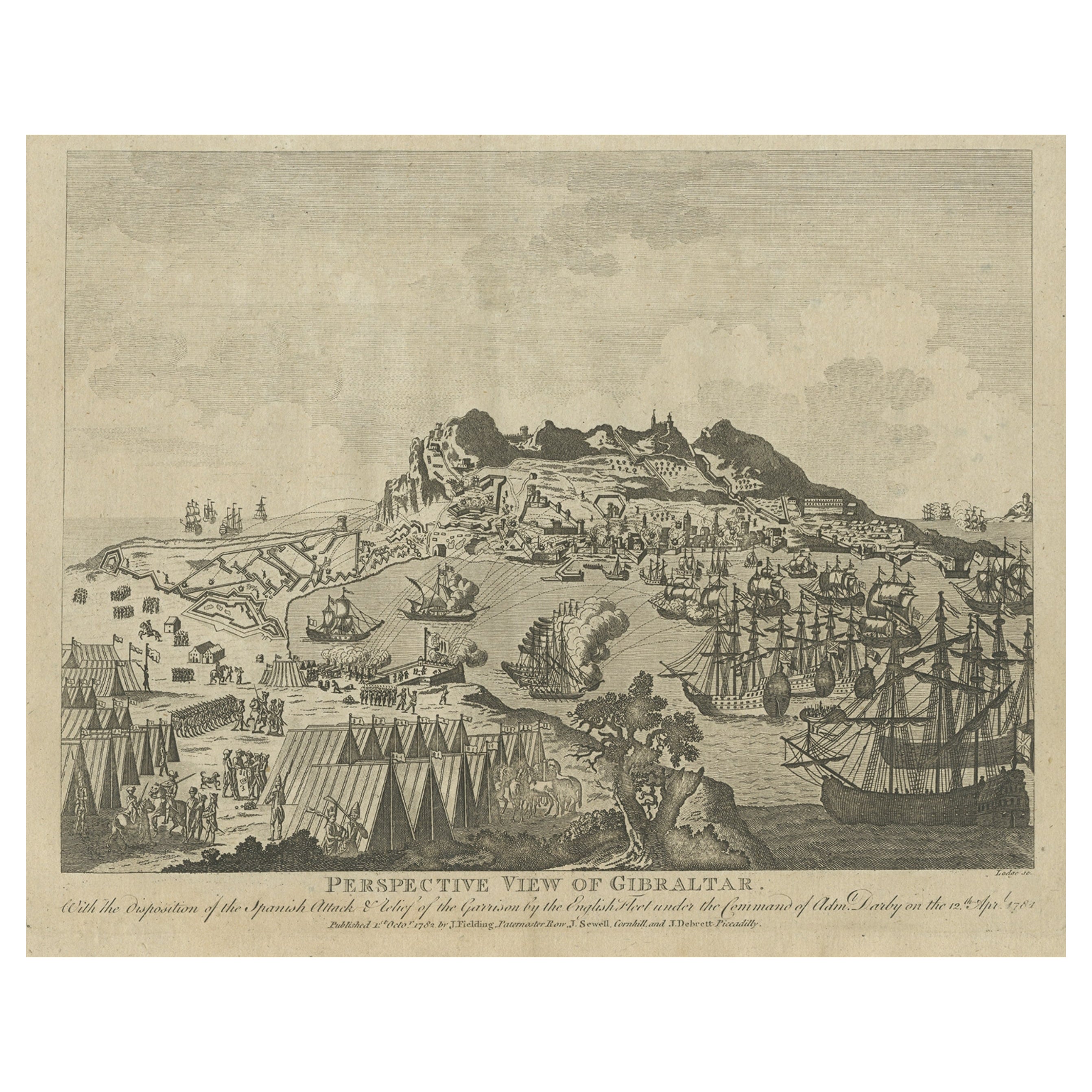
Antique Print of Gibraltar Showing the Spanish and English Fleet, 1782
Located in Langweer, NL
Antique print titled 'Perspective View of Gibraltar. With the the Disposition of the Spanish Attack, and Relief of the Garrison by the English Fleet under the command of Admiral Darby, 12 April 1781'. View of the island clearly showing the fortifications, during a bombardment, with the Spanish encampments on the left wing of the bay and a few Spanish ships...
Category
Antique 18th Century Prints
Materials
Paper
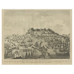
$412 Sale Price
20% Off
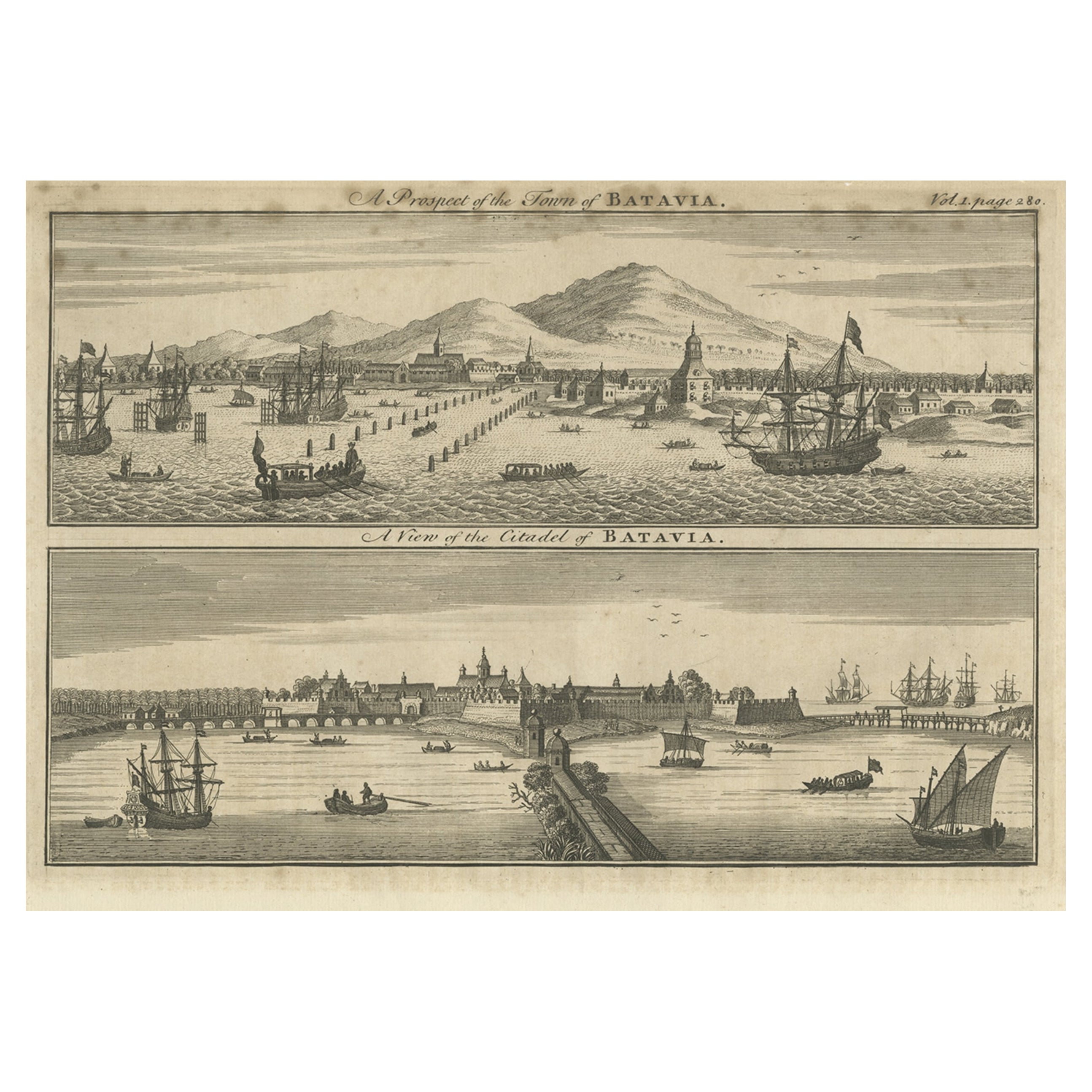
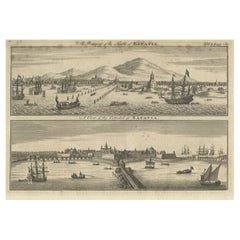
Antique Print of Batavia 'Jakarta', in the Dutch East Indies, 1744
Located in Langweer, NL
Two views on one plate titled 'A Prospect of The Town of Batavia (and) A View of the Citadel of Batavia'. Beautiful views of Batavia (Jakarta), Indonesia. The upper view shows the ci...
Category
Antique 18th Century Prints
Materials
Paper
$211 Sale Price
20% Off
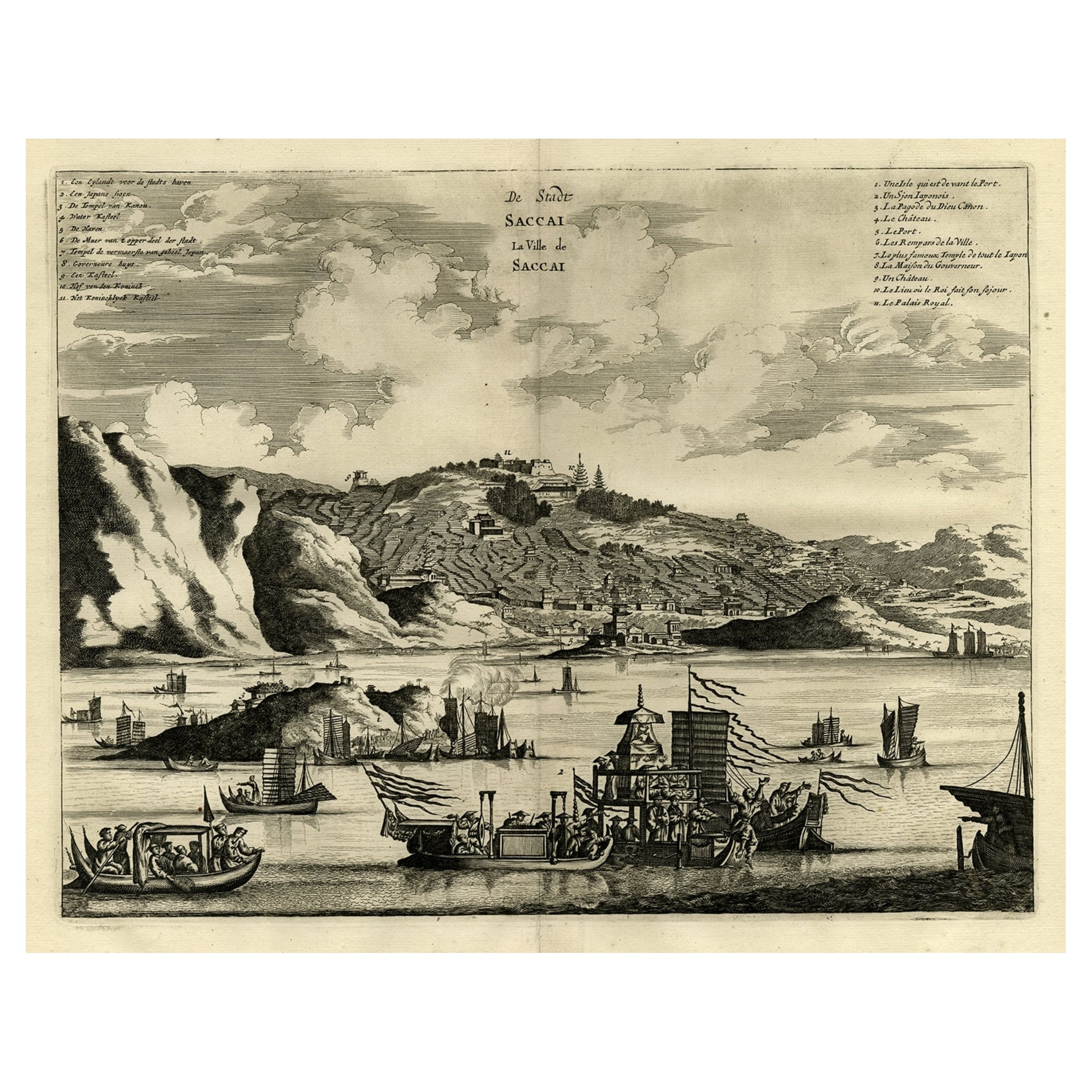
Original Antique Engraving of Sakai in the Osaka Prefecture, Japan, 1669
Located in Langweer, NL
Antique print, titled: 'De Stadt Saccai. La Ville de Saccai.' - ('The City Saccai').
This plate shows a view of Sakai in the Osaka Prefecture, Japan. Sakai has been one of the la...
Category
Antique 1660s Maps
Materials
Paper
$623 Sale Price
20% Off
You May Also Like
Original Antique Print of Cairo, Egypt. Dated 1809
Located in St Annes, Lancashire
Wonderful image of Cairo
Fine copper-plate engraving
Published by Sherwood & Co.
Dated 1809
Unframed.
Free shipping
Category
Antique Early 1800s English Moorish Prints
Materials
Paper
18th Century French Map and City View of Joppe/Jaffa (Tel Aviv) by Sanson
By Nicholas Sanson d'Abbeville
Located in Alamo, CA
An original antique engraving entitled "Joppe; in ’t Hebreeusch by ouds Japho; hedendaags Japha, of Jaffa; volgens d’aftekening gedaan 1668", by Nicholas Sanson d'Abbeville (1600 - 1667). This is a view of the city of Joppe (in Hebrew Japho), now called Japha or Jaffa, the harbor portion of modern day Tel Aviv, Israel as it appeared in 1668 . It depicts a very busy harbor with numerous boats. A large ship on the left appears to be firing its canons and a small ship on the right appears to be sitting very low in the water, either heavily loaded with cargo or sinking. The town is seen on the far shore with a fortress on a hill across in the background. The map is printed from the original Sanson copperplate and was published in 1709 by his descendants.
The map is presented in an ornate brown wood frame embellished by gold-colored leaves and gold inner trim with a double mat; the outer mat is cream-colored and the inner mat is black. There is a central vertical fold, as issued. There are two small spots in the lower margin and one in the upper margin, as well as two tiny spots adjacent to the central fold. 1717 is written below the date 1668 in the inscription. The map is otherwise in very good condition.
Another map of the "Holy Land" (by Claes Visscher in 1663), with an identical style frame and mat is available. This pair of maps would make a wonderful display grouping. Please see Reference #LU117324709892.
Artist: Nicholas Sanson d'Abbeville (1600 - 1667) and his descendents were important French cartographer's active through the 17th century. Sanson started his career as a historian and initially utilized cartography to illustrate his historical treatises. His maps came to the attention of Cardinal Richelieu and then King Louis XIII of France, who became a supporter and sponsor. He subsequently appointed Sanson 'Geographe Ordinaire du Roi' the official map maker to the king. Sanson not only created maps for the king, but advised him on geographical issues and curated his map collection...
Category
Early 1700s Prints and Multiples
Materials
Engraving

Antique Voc Print Holland Malaysia Old Map Melaka History, 1663
Located in Amsterdam, Noord Holland
From my own collection I offer this impressive Antique print of the city of Malakka
A very interesting piece for collectors . It is an museum piece from the Dutch Institute of Orien...
Category
Antique 17th Century European Paintings
Materials
Paper

$293 Sale Price
20% Off
Alexandria, Egypt, copper-line engraving by Cornelius de Bruyn , 1690
By Cornelius de Bruyn
Located in Melbourne, Victoria
'Alexandria'
A view of the great harbour from a little behind the shoreline.
Cornelis de Bruijn was a Dutch artist and traveler. He is best known for his drawings of the ruins of ...
Category
Late 17th Century Naturalistic Landscape Prints
Materials
Engraving, Etching

Ancient View of La Valetta - Original Lithograph - Early-19th Century
Located in Roma, IT
La Valetta is an original modern artwork realized in Italy in the first half of the 19th Century.
Original Lithograph on Ivory Paper.
Inscripted in capital letters on the lower ma...
Category
1850s Modern Figurative Prints
Materials
Lithograph
17th-18th Century Siege of Graves Mapping Engraving By Willian III
Located in Kingston, NY
RARE French 17th-18th Century Enhanced Siege of Graves Mapping Engraving BY William III, also widely known as William of Orange,
The Siege of Grave in Dutch Brabant started by Monsie...
Category
Antique 17th Century French Prints
Materials
Paper

More Ways To Browse
Agresti Safe
Antique Armorial Shield
Antique Bronze Kitchen Cabinet Hardware
Antique Carved Oak Eagles
Antique Chinese Ducks
Antique Chinese Tapered Cabinet
Antique Church Salvage
Antique Cisterns
Antique Cobalt Stoneware
Antique Elephant Foot
Antique English Delftware
Antique Inro
Antique Japanese Inro
Antique Mexican Textiles
Antique Russian Clock
Antique Russian Clocks
Antique Spanish Clocks
Antique Supper Table