Items Similar to Original Antique Engravings of Various Churches on Ceylon 'Sri Lanka', 1732
Want more images or videos?
Request additional images or videos from the seller
1 of 6
Original Antique Engravings of Various Churches on Ceylon 'Sri Lanka', 1732
$287.55
$359.4420% Off
£214.03
£267.5320% Off
€240
€30020% Off
CA$393.88
CA$492.3520% Off
A$438.08
A$547.6020% Off
CHF 228.75
CHF 285.9420% Off
MX$5,330.94
MX$6,663.6820% Off
NOK 2,921.50
NOK 3,651.8720% Off
SEK 2,739.85
SEK 3,424.8120% Off
DKK 1,827.04
DKK 2,283.8020% Off
Shipping
Retrieving quote...The 1stDibs Promise:
Authenticity Guarantee,
Money-Back Guarantee,
24-Hour Cancellation
About the Item
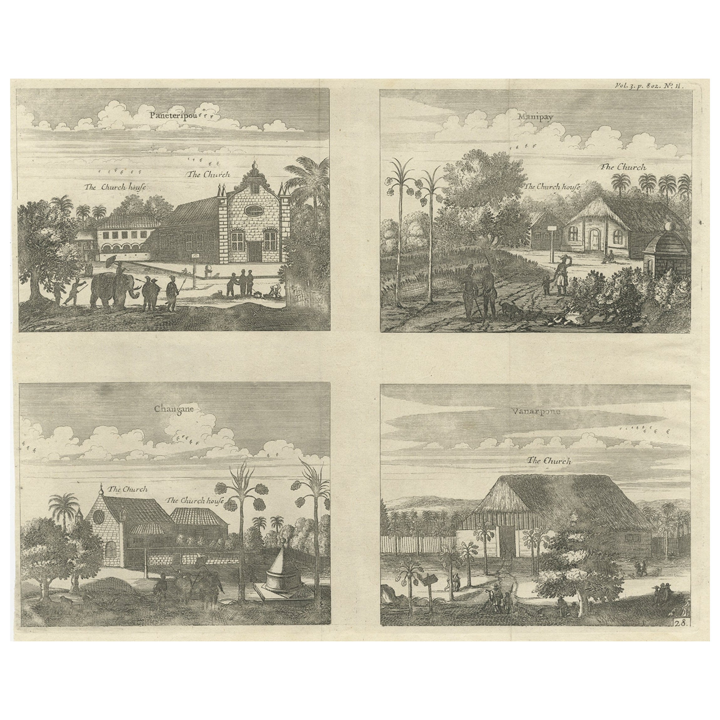
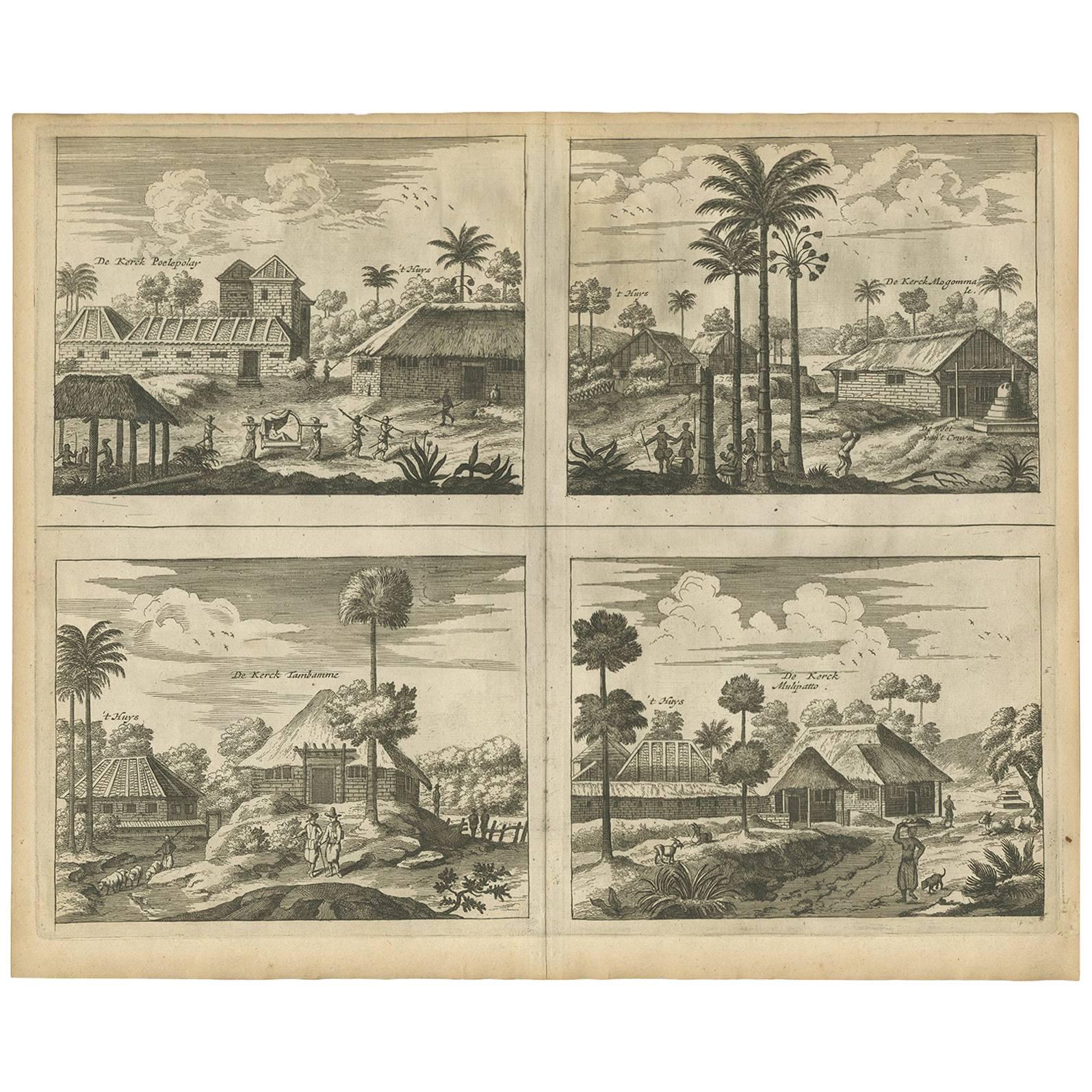
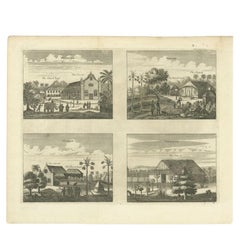
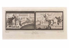
Antique print titled 'The Church Poelepolay, The Church Mogommate, The church Tambamme, the Church Mulipatto'. Antique print with four views of the churches of Poelepolay, Mogommate, Tambamme, Mulipatto (Ceylon/Sri Lanka). This print originates from 'A Collection of Voyages and Travels, some now first printed from original manuscripts others now first printed in English'.
Artists and Engravers: Published by Awnsham and John Churchill.
Condition: Very good, general age-related toning. Please study image carefully.
Date: 1732
Overall size: 41.5 x 34 cm.
Image size: 34.5 x 27 cm.
Whilst cartography holds a special place in our collection, we also offer thousands of antique prints covering fields of interest as diverse as architecture, natural history, religion, ethnology and many more. Antique prints have long been appreciated for both their aesthetic and investment value. They were the product of engraved, etched or lithographed plates. These plates were handmade out of wood or metal, which required an incredible level of skill, patience and craftsmanship. Whether you have a house with Victorian furniture or more contemporary decor an old engraving can enhance your living space. We offer a wide range of authentic antique prints for any budget.
- Dimensions:Height: 13.39 in (34 cm)Width: 16.34 in (41.5 cm)Depth: 0 in (0.01 mm)
- Materials and Techniques:
- Period:
- Date of Manufacture:1732
- Condition:Condition: Very good, general age-related toning. Please study image carefully.
- Seller Location:Langweer, NL
- Reference Number:Seller: BGI-014191stDibs: LU3054329330242
About the Seller
5.0
Recognized Seller
These prestigious sellers are industry leaders and represent the highest echelon for item quality and design.
Platinum Seller
Premium sellers with a 4.7+ rating and 24-hour response times
Established in 2009
1stDibs seller since 2017
2,508 sales on 1stDibs
Typical response time: <1 hour
- ShippingRetrieving quote...Shipping from: Langweer, Netherlands
- Return Policy
Authenticity Guarantee
In the unlikely event there’s an issue with an item’s authenticity, contact us within 1 year for a full refund. DetailsMoney-Back Guarantee
If your item is not as described, is damaged in transit, or does not arrive, contact us within 7 days for a full refund. Details24-Hour Cancellation
You have a 24-hour grace period in which to reconsider your purchase, with no questions asked.Vetted Professional Sellers
Our world-class sellers must adhere to strict standards for service and quality, maintaining the integrity of our listings.Price-Match Guarantee
If you find that a seller listed the same item for a lower price elsewhere, we’ll match it.Trusted Global Delivery
Our best-in-class carrier network provides specialized shipping options worldwide, including custom delivery.More From This Seller
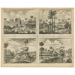
View AllAntique Print of Various Churches on Ceylon by Churchill, 1744
Located in Langweer, NL
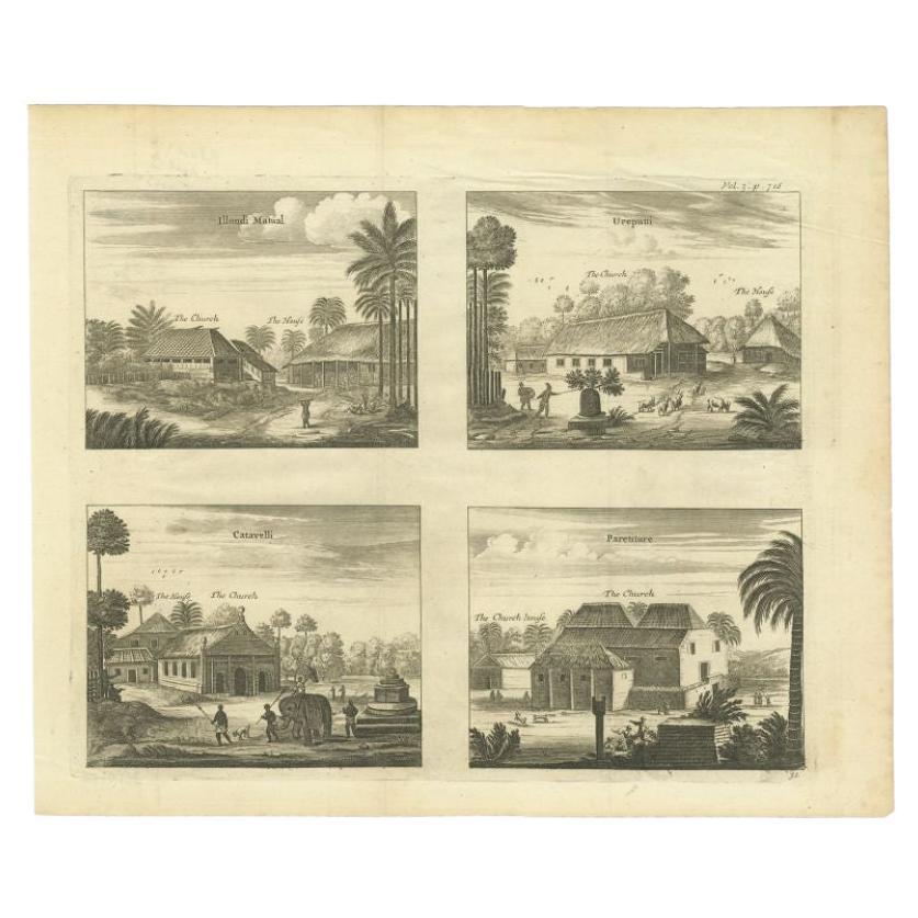
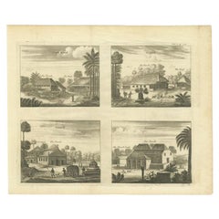
Antique print titled 'Illondi Matual, Ureputti, Catavelli, Paretiture'. Antique print with four views of the churches of Ilondi Matual, Ureputti, Catavelli and Paretiture. (Ceylon/Sr...
Category
Antique 18th Century Prints
Materials
Paper
$325 Sale Price
20% Off
Antique Print of Various Churches on Ceylon by Churchill, 1744
Located in Langweer, NL
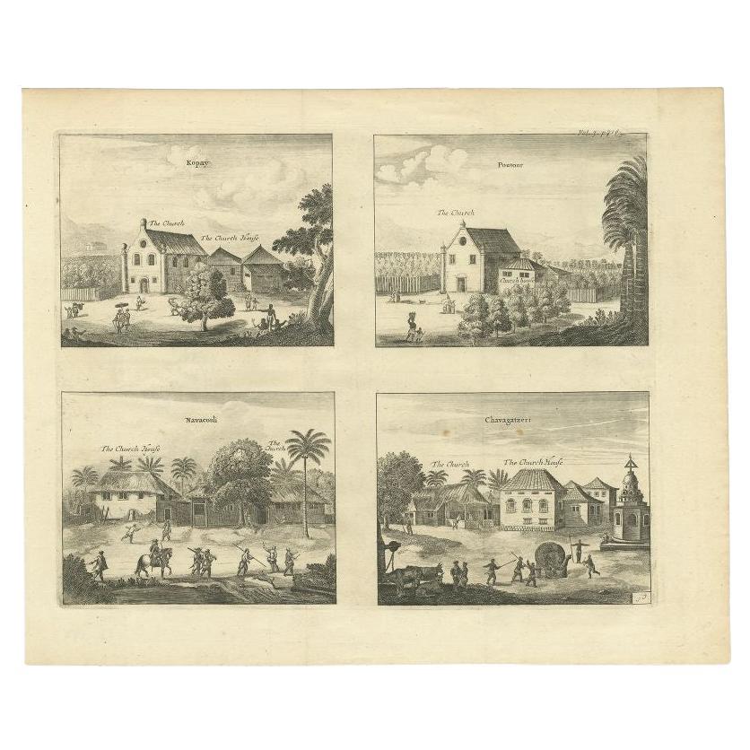
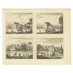
Antique print titled 'Kopay, Poutour, Navacouli, Chavagatzeri'. Antique print with four views of the churches of Kopay, Poutour, Navacouli and Chavagatzeri (Ceylon/Sri Lanka). This p...
Category
Antique 18th Century Prints
Materials
Paper
$325 Sale Price
20% Off
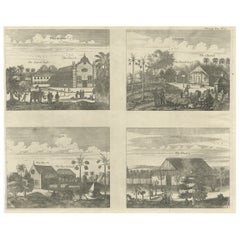
Antique Print of Various Churches on Ceylon or Nowadays Sri Lanka, 1732
Located in Langweer, NL
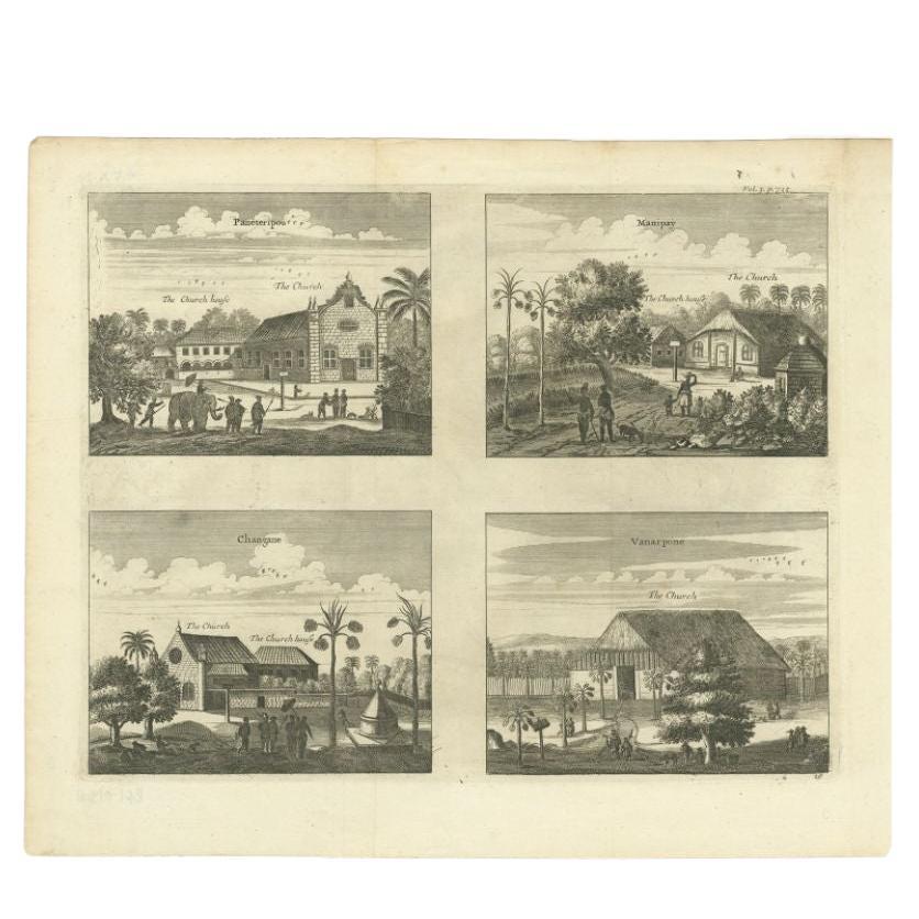
Antique print titled 'Paneteripou, Manipay, Changane, Vanarpone'. Antique print with four views of the churches of Paneteripoum, Manipay, Changane and Vanarpone (Ceylon/Sri Lanka). This print originates from 'A Collection of Voyages and Travels, some now first printed from original manuscripts others now first printed in English'.
Artists and Engravers: Published by Awnsham and John Churchill...
Category
Antique 18th Century Prints
Materials
Paper
$364 Sale Price
20% Off
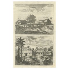
Antique Print of the Churches of Cathay and Waranni in Ceylon 'Sri Lanka', 1703
Located in Langweer, NL
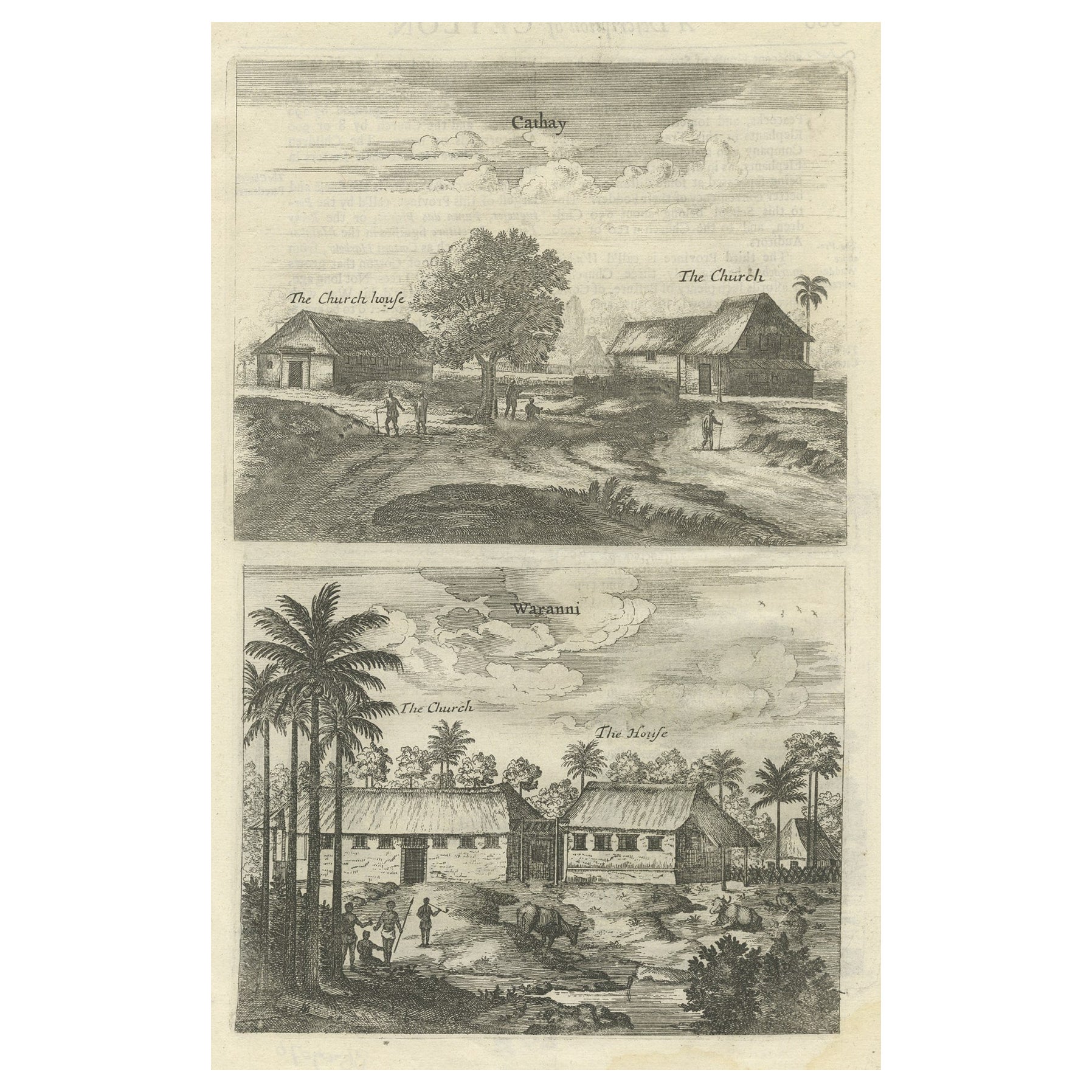
Antique print titled 'Cathay, Waranni'. Copper engraving of the churches of Cathay and Waranni, Sri Lanka (Ceylon). This print originates from 'A true and exact description of the mo...
Category
Antique 18th Century Prints
Materials
Paper
$182 Sale Price
20% Off
Antique Print of various Churches on Ceylon or Nowadays Sri Lanka, 1704
Located in Langweer, NL
Antique print titled 'Paneteripou, Manipay, Changane, Vanarpone'. Antique print with four views of the churches of Paneteripoum, Manipay, Changane and Vanarpone (Ceylon/Sri Lanka). This print originates from 'A Collection of Voyages and Travels, some now first printed from original manuscripts'.
Artists and Engravers: Published by Awnsham and John Churchill...
Category
Antique 18th Century Prints
Materials
Paper
$210 Sale Price
20% Off
Antique Print of the Churches of Poelepolay, Mogommate, Tambamme and Mulipatto
Located in Langweer, NL
Antique print titled 'De Kerck Poelepolay / De Kerck Mogommate / De Kerck Tambamme / De Kerck Mulipatto.' Four views of the churches of Poelepolay, Mogommate, Tambamme, Mulipatto (Ce...
Category
Antique Late 17th Century Prints
Materials
Paper
$249 Sale Price
20% Off
You May Also Like
Antique Voc Print Holland Malaysia Old Map Melaka History, 1663
Located in Amsterdam, Noord Holland
From my own collection I offer this impressive Antique print of the city of Malakka
A very interesting piece for collectors . It is an museum piece from the Dutch Institute of Orien...
Category
Antique 17th Century European Paintings
Materials
Paper

$293 Sale Price
20% Off
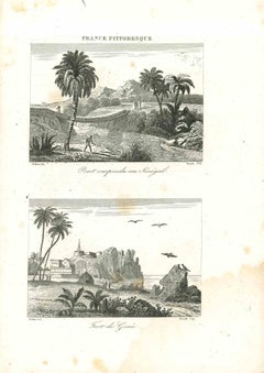
Views of Senegal - Original Lithograph - 19th century
Located in Roma, IT
Views of Senegal is an original lithograph artwork realized by an Anonymous engraver of the 19th century.
Printed in the series of "France Pittoresque".
Titled "France Pittoresqu...
Category
19th Century Modern Figurative Prints
Materials
Lithograph
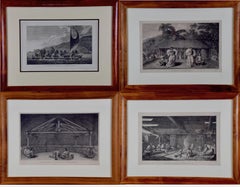
Four Koa Wood Framed 18th C. Engravings from Captain Cook's 3rd Voyage Journal
By John Webber
Located in Alamo, CA
A grouping of four framed engravings of Hawaii, Tahiti, Tonga and Vancouver Island from the atlas of the official British Admiralty sanctioned journal of Captain Cook's 3rd Voyage entitled "A Voyage to the Pacific Ocean Undertaken by the Command of His Majesty, for Making Discoveries in the Northern Hemisphere", published upon completion of the voyage in London in 1784 by Strahan & Cadell. These engravings were made from drawings by John Webber (1752-1793), who was the artist on Captain James Cook's 3rd and final voyage of discovery. The set of engravings includes: "A Canoe of the Sandwich Islands, the Rowers Masked", Plate 65 in the atlas; "A Dance in Otaheite" (Tahiti), Plate 28; "King of the Friendly Islands" (Tonga), plate 20; "Inside of a House in Nootka Sound" (Canada), plate 42.
These engravings are professionally framed in Koa wood, the same wood as was used to make the canoes of the ancient Hawaiians. Koa wood is legendary in Hawaii. Not only is this amazing wood native to Hawaii, but it is known for the deep rich colors and varied grain pattern. Koa has an honored heritage in Hawaii and is highly revered and sacred. The word “koa” means “warrior” in Hawaiian. The warriors of King Kamehameha the Great, created canoes and weapons from a wood plentiful on the Big Island of Hawaii. This wood became synonymous with the warriors themselves, and it became known as koa.
These four engravings would make a wonderful grouping for a display of 2, 3 or 4 prints. They may be purchased separately or in groups on 1stDibs. Their listing Reference #'s are: LU117324682432, LU117324682022, LU117324684052 and LU117324684062. A discount is available for a grouping depending on the number of items included.
Hawaii was discovered by Captain Cook (1728-1779) during this voyage. Hawaii was originally called The Sandwich Islands in honor of The Earl of Sandwich...
Category
1780s Other Art Style Landscape Prints
Materials
Engraving
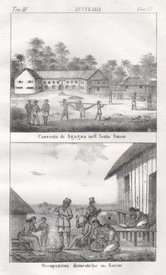
Guam, Convent and native inhabitants, mid 19th century lithograph. Oceania.
Located in Melbourne, Victoria
'Convento di agagna nell' Isola Guam. Occupazioni domestiche in Guam.'
Italian lithograph, c1841. Originally from 'Galleria universale di tutti i popoli del mondo' by Giuseppe Anton...
Category
Mid-19th Century Naturalistic Figurative Prints
Materials
Lithograph
Collection of Colonial Drawings Depicting Indonesia by J.G. Sinia '1875-1948'
Located in Amsterdam, NL
A Collection of Thirteen Ink and Chalk Drawings by Johan Gerard Sinia (1875-1948)
All framed in gilt-metal or giltwood frames
Sinia started his professional career as an army off...
Category
Early 20th Century Indonesian Dutch Colonial Paintings and Screens
Materials
Other
$29,953 / set
Free Shipping
Seascapes with Monuments and Figures - Etching by Luigi Aloja - 18th Century
Located in Roma, IT
Seascapes With Monuments and Figures is an Etching realized by Luigi Aloja (1783-1837).
The etching belongs to the print suite “Antiquities of Herculaneum Exposed” (original title:...
Category
Late 18th Century Old Masters Figurative Prints
Materials
Etching
More Ways To Browse
Antique Ceylon
Medici Jewelry
Original Japanese Kimono
Oscar Bach Bronze
Pair Elephant Seats
Pair Of Bamboo Chests
Pair Of Staffordshire Dogs
Pair Porcelain Bird Figures
Panther 1920
Pompeii Wall Painting
Priest Japanese
Prints By Sir William Hamilton
Raku Tea
Rare Antique Stained Glass Windows
Rattan Bed King
Reclining Dog
Refurbished Vintage Chest Of Drawers
Retro 1970s China Cabinet