Items Similar to Jacques Liozu's 1951 illustrated map of the region of Pays d'Ouest


Want more images or videos?
Request additional images or videos from the seller
1 of 8
Jacques LiozuJacques Liozu's 1951 illustrated map of the region of Pays d'Ouest1951
1951
$831.53
£618.07
€700
CA$1,154.21
A$1,294.81
CHF 669.46
MX$15,616.13
NOK 8,516.88
SEK 7,976.86
DKK 5,328.85
About the Item
Jacques Liozu's 1951 illustrated map of the Pays d'Ouest is a remarkable cartographic work that skilfully combines art and geography. Jacques Liozu, the famous French artist-cartographer, created this map to highlight the regions of western France and their geographical and cultural diversity.
The map's illustration is an eloquent example of Liozu's artistic approach. Using vibrant colors and delicate artistic motifs, he has meticulously depicted the mountains, rivers, towns and villages of the Pays d'Ouest. Every detail testifies to his talent and attention to realism.
This map goes beyond its purely geographical purpose to become a captivating work of art that celebrates the richness and beauty of these French regions. It invites the viewer to explore this land of varied landscapes, from mountain peaks to the Atlantic coast.
In 1951, the map was also a valuable tool for travelers, students and the curious who wanted to learn more about the regions of western France.
Today, Jacques Liozu's illustrated map of the Pays d'Ouest has become a sought-after collector's item for cartography enthusiasts and art lovers alike. It is a shining testament to Liozu's talent as an artist-cartographer and his ability to transform a simple map into a dazzling work of art. This map continues to amaze and inspire, reminding us of the importance of art in our appreciation and understanding of the world around us.
Map - France - Tourism
Angoulême - La Rochelle - Niort - Poitiers - Cognac
Odé Paris
- Creator:Jacques Liozu (1910 - 1974, French)
- Creation Year:1951
- Dimensions:Height: 16.15 in (41 cm)Width: 22.05 in (56 cm)
- Medium:
- Period:
- Condition:Good condition.
- Gallery Location:PARIS, FR
- Reference Number:1stDibs: LU1792212725282
About the Seller
5.0
Platinum Seller
Premium sellers with a 4.7+ rating and 24-hour response times
Established in 2021
1stDibs seller since 2022
170 sales on 1stDibs
Typical response time: 1 hour
- ShippingRetrieving quote...Shipping from: PARIS, France
- Return Policy
Authenticity Guarantee
In the unlikely event there’s an issue with an item’s authenticity, contact us within 1 year for a full refund. DetailsMoney-Back Guarantee
If your item is not as described, is damaged in transit, or does not arrive, contact us within 7 days for a full refund. Details24-Hour Cancellation
You have a 24-hour grace period in which to reconsider your purchase, with no questions asked.Vetted Professional Sellers
Our world-class sellers must adhere to strict standards for service and quality, maintaining the integrity of our listings.Price-Match Guarantee
If you find that a seller listed the same item for a lower price elsewhere, we’ll match it.Trusted Global Delivery
Our best-in-class carrier network provides specialized shipping options worldwide, including custom delivery.More From This Seller
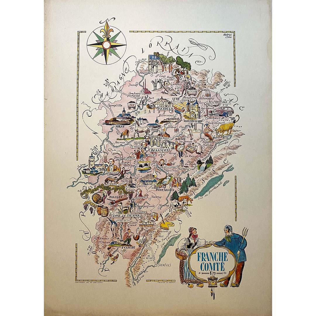
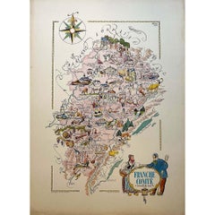
View AllJacques Liozu's 1951 illustrated map of the region of Franche-Comté
By Jacques Liozu
Located in PARIS, FR
Jacques Liozu's 1951 illustrated map of Franche-Comté is a cartographic work of great beauty and precision. Jacques Liozu, a renowned French artist and cartographer, created this map...
Category
1950s Prints and Multiples
Materials
Lithograph, Paper
1947 original map Gouvernement Généraux du Poitou, du Pays d'Aunis
Located in PARIS, FR
The 1947 original map Gouvernement Généraux du Poitou, du Pays d'Aunis et de Saintonge Angoumois, created by Louis Larmat and printed by Dorel in Paris, is a beautifully detailed cartographic representation of a historically significant region in western France. This map, part of Larmat’s extensive body of work, is known for its artistic craftsmanship and geographical precision, offering a comprehensive view of the historical administrative regions of Poitou, Aunis, Saintonge, and Angoumois, which played key roles in the political and cultural history of France.
Louis Larmat is celebrated for his contributions to cartography, particularly for his ability to merge historical context, topographical detail, and aesthetic elegance in his maps. His works, especially those focusing on the vinicultural regions of France, are highly respected for their accuracy and artistry. This particular map, although focusing on a more political and historical aspect rather than the wine regions he is most famous for, continues his tradition of detailed regional documentation. Larmat’s cartographic works often transcended the realm of simple geographical depiction, becoming historical documents that encapsulate the cultural essence of the regions they portray.
This map illustrates the general governments (administrative divisions) of the provinces of Poitou, Aunis, Saintonge, and Angoumois, regions that are steeped in history. These areas, situated along France’s western coastline, have been integral to the country’s political, economic, and cultural development over centuries. The region of Poitou, for example, is historically known as the birthplace of Eleanor of Aquitaine...
Category
1940s Prints and Multiples
Materials
Lithograph, Paper

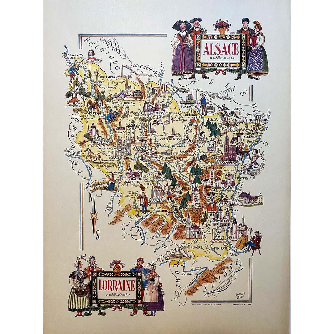
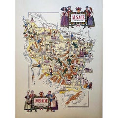
Jacques Liozu's 1951 illustrated map of Alsace and Lorraine in France
By Jacques Liozu
Located in PARIS, FR
Jacques Liozu's 1951 illustrated map of Alsace and Lorraine is a remarkable work of cartography that blends art and geography to offer a poetic and moving vision of these emblematic ...
Category
1950s Prints and Multiples
Materials
Lithograph, Paper
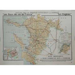
1947 original map "Le Cognac Bois ordinaires & Bois communs" by Larmat
Located in PARIS, FR
The 1947 original map Atlas de la France Vinicole - Les Eaux-de-vie de France - Le Cognac Bois Ordinaires & Bois Communs dits à Terroir, created by Louis Larmat and printed by Dorel ...
Category
1940s Prints and Multiples
Materials
Lithograph, Paper
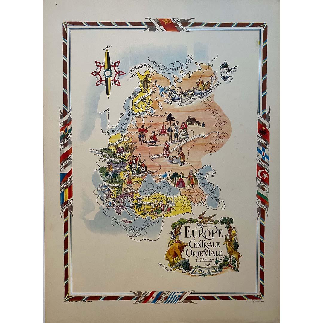
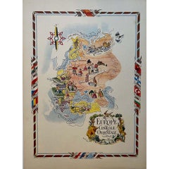
Jacques Liozu's 1951 illustrated map of Central and Eastern Europe
By Jacques Liozu
Located in PARIS, FR
Jacques Liozu's 1951 illustrated map of Central and Eastern Europe is a cartographic work of great beauty and precision. Jacques Liozu, the famous French artist-cartographer, created...
Category
1950s Prints and Multiples
Materials
Lithograph, Paper
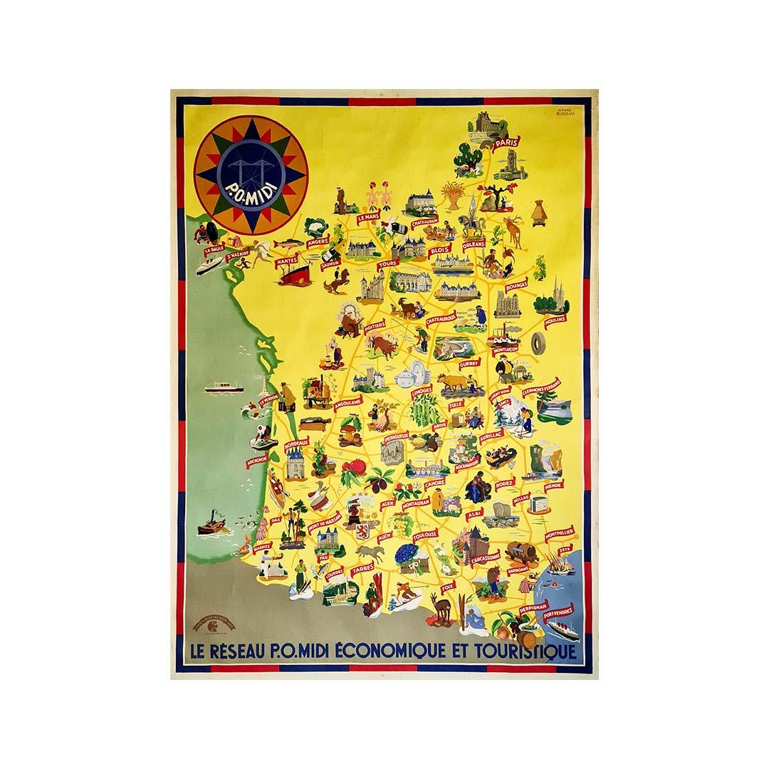
Circa 1935 map illustrated by André Giroux of the P.O Midi railroad network.
Located in PARIS, FR
Very beautiful map illustrated by André Giroux of the P.O Midi railroad network.
The railway company from Paris to Orleans and the Midi (PO Midi) is the n...
Category
1930s Prints and Multiples
Materials
Paper, Lithograph, Linen

You May Also Like
Antique Map of Doubs ‘France’ by V. Levasseur, 1854
By Victor Levasseur
Located in Langweer, NL
Antique map titled 'Dépt. du Doubs'. Map of the French department of Doubs, France. The whole is surrounded by elaborate decorative engravings designed to illustrate both the natural...
Category
Antique Mid-19th Century Maps
Materials
Paper
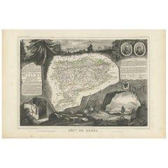
$171 Sale Price
20% Off
Antique Map of Côtes du Nord ‘France’ by V. Levasseur, 1854
By Victor Levasseur
Located in Langweer, NL
Antique map titled 'Dépt. des Côtes du Nord'. Map of the French department of Cotes du Nord, a maritime region in Brittany, France. The whole is surrounded by elaborate decorative en...
Category
Antique Mid-19th Century Maps
Materials
Paper
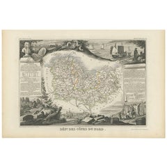
$190 Sale Price
20% Off
Antique Map of France by Johnston (1909)
Located in Langweer, NL
Antique map titled 'France'. Original antique map of France. With inset maps of France in provinces, part of the Riviera and Corsica. This map or...
Category
Early 20th Century Maps
Materials
Paper

$237 Sale Price
20% Off
Antique Map of Meurthe ‘France’ by V. Levasseur, 1854
Located in Langweer, NL
Antique map titled 'Dépt. de la Meurthe'. Map of the French department of Meurthe, France. Part of Lorraine and the Alsace-Lorraine wine region. This map originates from ‘Atlas Natio...
Category
Antique Mid-19th Century Maps
Materials
Paper
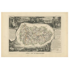
$171 Sale Price
20% Off
Antique Map of France under the Reign of Francois II, 1765
Located in Langweer, NL
Antique map France titled 'La Bretagne et le Cté de Penthièvre (..)'. Beautiful old map of France. This map originates from 'Atlas Historique de la France Ancienne et Moderne' by M. ...
Category
Antique 18th Century Maps
Materials
Paper
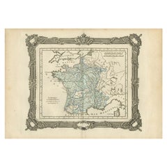
$140 Sale Price
20% Off
Hautes-Pyrénées Map - Original Lithograph - 19th Century
Located in Roma, IT
Hautes-Pyrénées Map is an original lithograph realized by an Anonymous engraver of the 19th Century.
Printed in series of "France Pittoresque" at the top center.
The state of prese...
Category
19th Century Modern Figurative Prints
Materials
Paper, Lithograph

More Ways To Browse
Illustrated Map
Cartographer Tool
George Rodrigue Blue Dog Signed
Ballet Russe Costume
Erotic Illustration
German Expressionist Poster
Hiroshige Woodcuts
Imaginations And Objects Of The Future
Lam Wifredo
Marc Chagall Pencil Signed
Pablo Picasso Ceramic Plates
Roy Lichtenstein Signed Lithograph
Van Dyck Etching
Violin Print
Alexander Calder 1969 Lithograph
Green River Project
Retro Pop Machine
Vintage Felt Picture