Items Similar to San Francisco Sicilian and Italian Fishermen: A 19th C. Hand-colored Woodcut
Want more images or videos?
Request additional images or videos from the seller
1 of 11
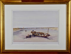
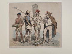
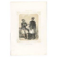
Henry François FarnySan Francisco Sicilian and Italian Fishermen: A 19th C. Hand-colored Woodcut1889
1889
$1,275
£965.04
€1,111.23
CA$1,813.82
A$1,964.82
CHF 1,034.56
MX$23,848.81
NOK 12,902.21
SEK 12,198.74
DKK 8,295.63
About the Item
This is a framed hand-colored woodcut engraving entitled "Sicilian and Italian Fisherman's Dock - San Francisco", created by Henry François Farny and published in Harper's Weekly in 1889. It depicts fisherman talking on a San Francisco dock, one holding a basket of fish. One fisherman is asleep on the left near a crab on the the wood dock. Several fisherman are working with their catch or sit in their boats, relaxing after their day of fishing. The masts of a tall ship is seen in the background extending above another dock.
This beautifully colored and framed original 19th century woodcut engraving is presented in a dark brown wood faux bark frame with a cream-colored mat and it is glazed with UV protected conservation glass. All materials used are archival. The frame measures 21.13" high and 27.25" wide by 1.13" deep. The print has a central vertical fold, as issued. It is in excellent condition.
Henry François Farny (1847-1916) was an American painter and illustrator whose parents emigrated from France. His work often depicted the common man and frequently the life of Native Americans in 19th-century United States.
- Creator:Henry François Farny (1847 - 1916, American)
- Creation Year:1889
- Dimensions:Height: 21.13 in (53.68 cm)Width: 27.25 in (69.22 cm)Depth: 1.13 in (2.88 cm)
- Medium:
- Period:
- Condition:
- Gallery Location:Alamo, CA
- Reference Number:Seller: # 40211stDibs: LU117329763792
About the Seller
5.0
Platinum Seller
Premium sellers with a 4.7+ rating and 24-hour response times
Established in 2011
1stDibs seller since 2019
293 sales on 1stDibs
Typical response time: 1 hour
- ShippingRetrieving quote...Shipping from: Alamo, CA
- Return Policy
Authenticity Guarantee
In the unlikely event there’s an issue with an item’s authenticity, contact us within 1 year for a full refund. DetailsMoney-Back Guarantee
If your item is not as described, is damaged in transit, or does not arrive, contact us within 7 days for a full refund. Details24-Hour Cancellation
You have a 24-hour grace period in which to reconsider your purchase, with no questions asked.Vetted Professional Sellers
Our world-class sellers must adhere to strict standards for service and quality, maintaining the integrity of our listings.Price-Match Guarantee
If you find that a seller listed the same item for a lower price elsewhere, we’ll match it.Trusted Global Delivery
Our best-in-class carrier network provides specialized shipping options worldwide, including custom delivery.More From This Seller
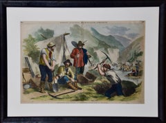
View All"California Gold Diggers": A 19th C. Hand-colored Woodcut Gold Rush Scene
By John Andrew
Located in Alamo, CA
This is a framed hand-colored woodcut engraving entitled "California Gold Diggers - A Scene From Actual Life At The Mines" created by John Andrew and publi...
Category
Mid-19th Century Landscape Prints
Materials
Woodcut
David Roberts' 19th Century Hand Colored Lithograph, St. Jean D'Acre
By David Roberts
Located in Alamo, CA
"St. Jean D'Acre" is a 19th century folio sized hand-colored lithograph from the "The Holy Land, Syria, Idumea, Arabia, Egypt and Nubia" volume of David Roberts’ large folio edition,...
Category
1840s Realist Landscape Prints
Materials
Lithograph
"View Towards the Pyramids": David Roberts' 19th Century Hand Colored Lithograph
By David Roberts
Located in Alamo, CA
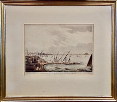
"View Towards the Pyramids" is a 19th century full folio sized hand-colored lithograph by David Roberts from his monumental publication "The Holy Land, Syria, Idumea, Arabia, Egypt, and Nubia", published in London in 1846. It depicts a scene of a boat on the Nile, along with several smaller boats. Saccara (Saqqara), near Memphis, the original capital of Egypt, can be seen in the background with its ancient Step Pyramid of Pharoah Djoser. This was the first Egyptian pyramid, designed by the physician and architect Imhotep. Pharoah Snofru’s (Sneferu) failed design Bent Pyramid and the subsequent replacement Red Pyramid can be seen in Dashour (Dashur). These structures preceded the more famous pyramids in Giza.
This lithograph is professionally framed in a gold-colored wood frame, double cream-colored mats and it is glazed with museum quality archival material. The print is in excellent condition.
There are four additional listings of David Roberts engravings of Egypt...
Category
1840s Realist Landscape Prints
Materials
Lithograph
Alexandria, Egypt & Lighthouse: A Hand-colored Aquatint & Engraving by L. Mayer
By Luigi Mayer
Located in Alamo, CA
This is a hand-colored aquatint and engraving entitled "Part of the New City of Alexandria, with the Light House", published in London by R. Bowyer from 1802-1805. The print was crea...
Category
Early 19th Century Romantic Portrait Prints
Materials
Engraving, Aquatint
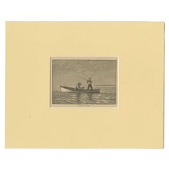
Fishing Off Hastings, England: A Framed 19th C. Engraving After J. M. W. Turner
By J.M.W. Turner
Located in Alamo, CA
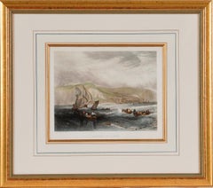
This beautiful 19th century framed engraving "Line Fishing Off Hastings" by William Miller is based on an original painting by the renowned British artist J.M.W. Turner, which depicts a scene of fishermen at work off the coast of the town of Hastings in East Sussex, England. The Miller engraving faithfully reproduces Turner's painting, capturing the same atmospheric quality and sense of motion. In the foreground of the image, a group of fishermen are shown in a small boat, with one man using a fishing line to catch fish. In the background, there is a larger ship, along with a view of the town of Hastings and the cliffs beyond. Overall, the Miller engraving "Line Fishing Off Hastings" is a beautiful and detailed representation of Turner's original painting, and provides a glimpse into life in a 19th century fishing community.
This colorful 19th century engraving is presented in a gold-colored wood frame and a cream-colored French mat highlighted with a light blue band and thinner mustard and gold-colored bands. There is a gold-colored fillet which further embellishes the engraving. The frame measures 18" high, 20.5" wide and 1" deep. The engraving, frame and mat are in excellent condition.
Joseph Mallord William (J.M.W.) Turner (1775-1851) was an English painter who is widely considered one of the greatest landscape painters in Western art history. Born in London, he showed a remarkable talent for art from a young age, and studied at the Royal Academy of Arts from the age of 14. He quickly gained recognition for his watercolor landscapes, which were highly innovative and expressive. Turner's style evolved over time, and he became increasingly interested in the effects of light and color. He traveled extensively throughout Europe, and his experiences of the natural world, particularly the sea and the sky, had a profound influence on his art. His paintings are known for their luminosity, atmospheric effects, and dramatic use of color. Despite facing criticism and ridicule from some of his contemporaries, Turner continued to push the boundaries of art, experimenting with new techniques and styles throughout his career. He was a prolific artist, creating thousands of paintings, sketches, and watercolors, and his legacy continues to inspire artists today.
William Miller (1796-1882) was an English engraver and publisher, best known for his work in reproducing the paintings of J.M.W. Turner. Miller was born in Bristol and began his career as an engraver at a young age, working for a variety of publications and artists. In the early 1820s, Miller began working with Turner, engraving many of the artist's most famous works, including "The Fighting Temeraire...
Category
Mid-19th Century Romantic Landscape Prints
Materials
Engraving
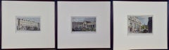
Three 19th C. Hand Colored Engravings of London Architecture by T. Shepherd
By Thomas Hosmer Shepherd
Located in Alamo, CA
A set of three hand-colored engravings from "Metropolitan Improvements; or London in the Nineteenth Century", published in London, England in 1828. The scenes were drawn by Thomas Ho...
Category
1820s Realist Landscape Prints
Materials
Engraving
You May Also Like
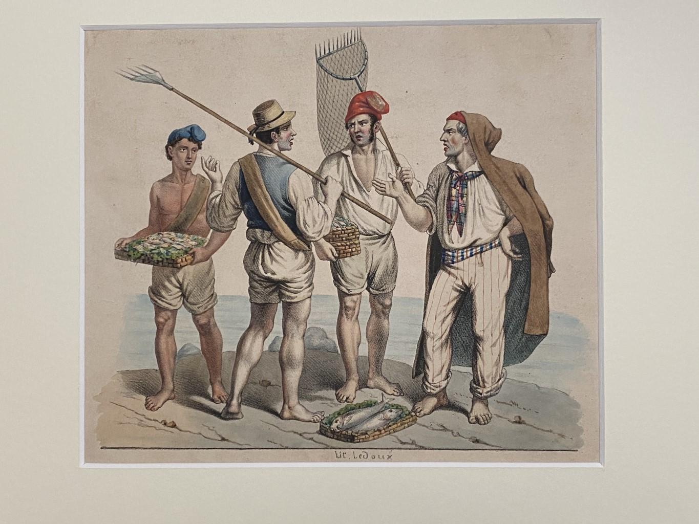
Neapolitan Fishermen - Original Gouache - 19th Century
Located in Roma, IT
Neapolitan Fishermen is an original modern artwork realized by Anonymous Artist of thr XIX Century.
Original gouache.
Hand-signed on the lower center corner: "LeDoux".
The work is...
Category
19th Century Modern Figurative Prints
Materials
Gouache
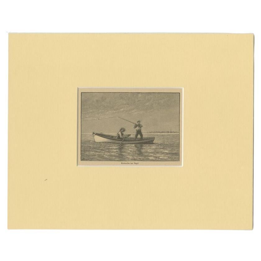
Antique Print of Fishermen, circa 1900
Located in Langweer, NL
Antique print titled 'Auswerfen der Angel'. Original antique print of fishermen. Published circa 1900.
Artists and Engravers: Anonymous.
Condition: Good, general age-related to...
Category
Antique 19th Century Prints
Materials
Paper
$124 Sale Price
20% Off
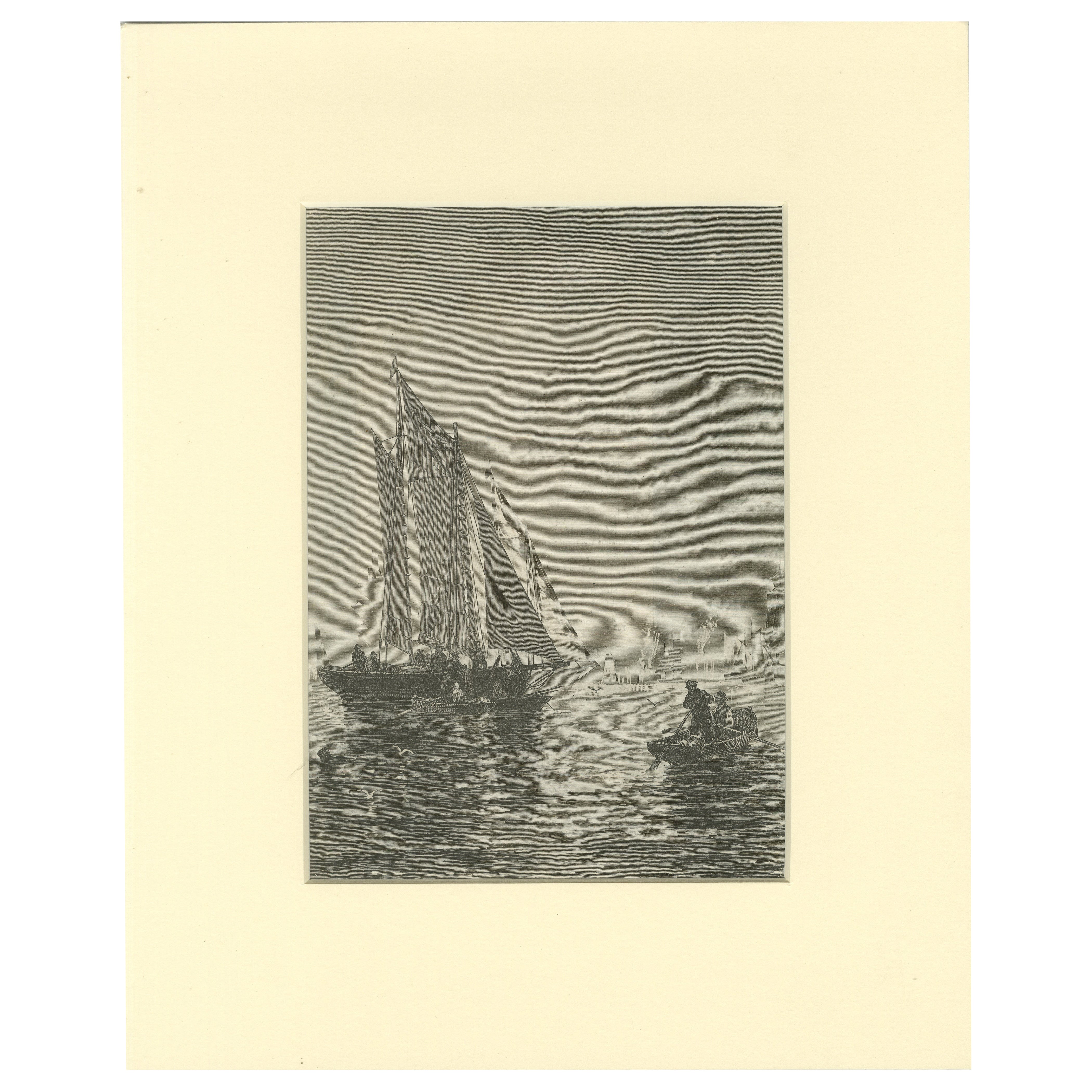
19th-Century Maritime Engraving – Fishing Boats and Rowers at Sea
Located in Langweer, NL
19th-Century Maritime Engraving – Fishing Boats and Rowers at Sea
This evocative 19th-century maritime engraving presents a lively coastal scene featuring two fishing vessels under ...
Category
Antique Late 19th Century European Prints
Materials
Paper

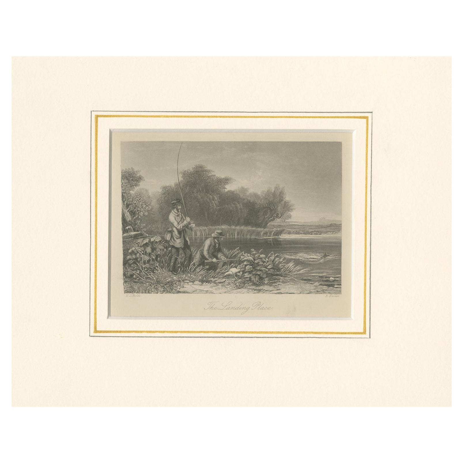
Antique Print of Fishermen by Rogerson
Located in Langweer, NL
Antique print titled 'The Landing Place'. Original antique print of fishermen. Engraved by E. Hacker. Published by Rogerson, 1863.
Category
Antique Mid-19th Century Prints
Materials
Paper
$95 Sale Price
20% Off
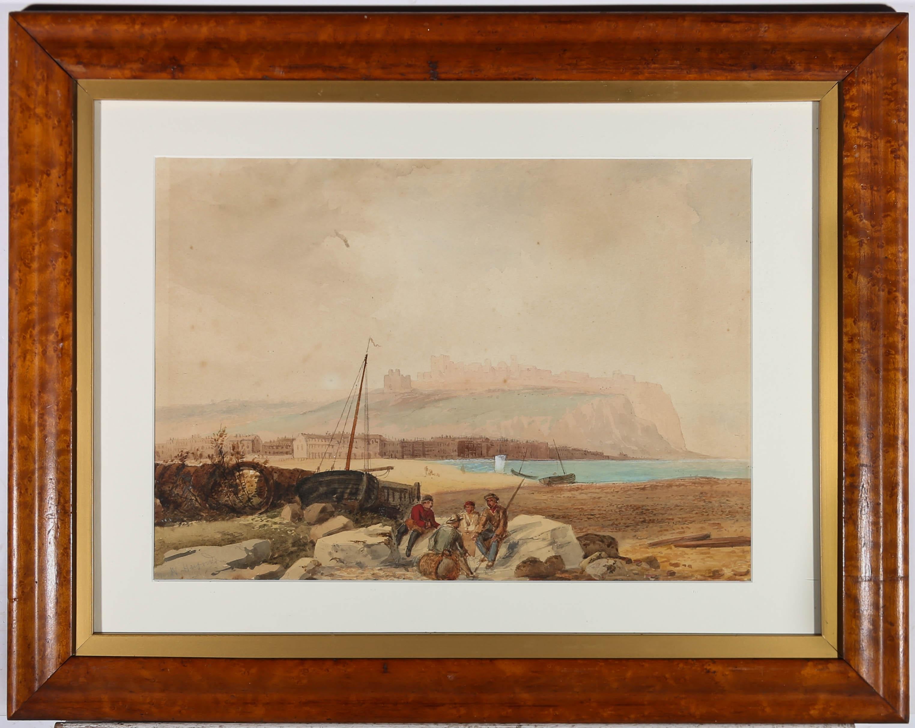
William Henry Harford (1840-1917) - Framed Watercolour, Fisherman Scene
Located in Corsham, GB
A fine watercolor seascape by William Harford, depicting fisherman gathered on rocks by the beach. A castle is just visible in the background, high up on a cliff. Signed in graphite ...
Category
Late 19th Century Figurative Drawings and Watercolors
Materials
Watercolor
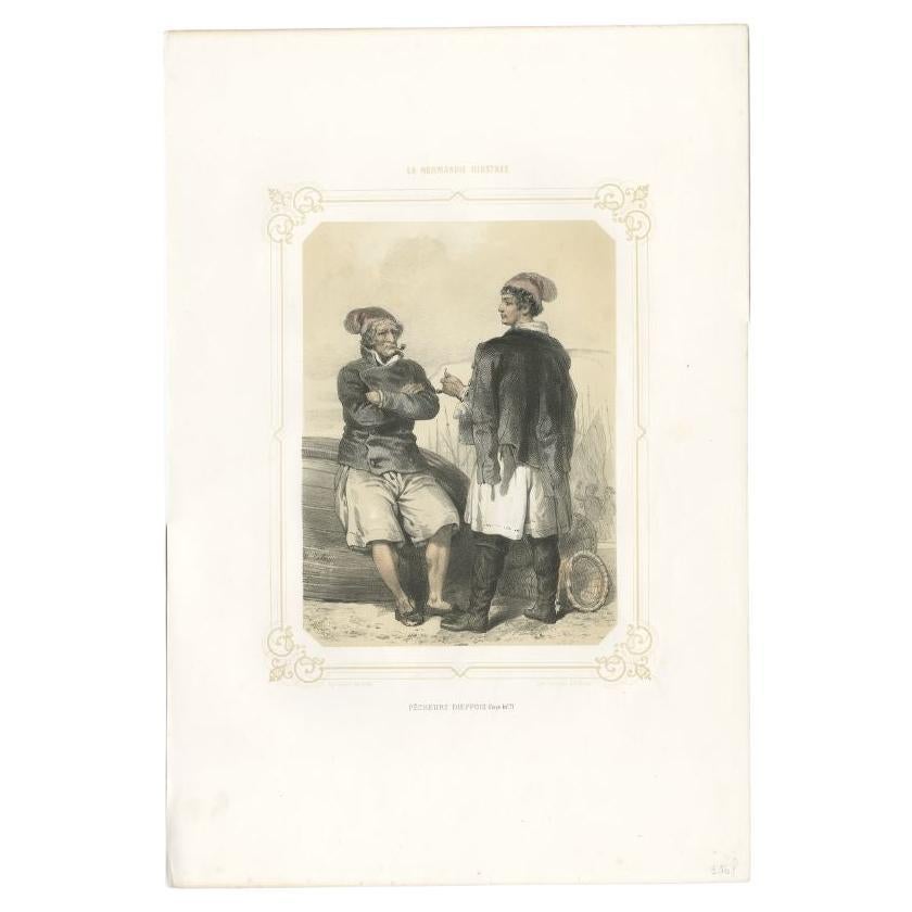
Antique Print of Fishermen from Dieppe by Charpentier, 1852
Located in Langweer, NL
Antique print titled 'Pêcheurs Dieppois'. Old print depicting fishermen from Dieppe, France. This print originates from 'La Normandie Illustrée' by R. Bor...
Category
Antique 19th Century Prints
Materials
Paper
$210 Sale Price
20% Off