Items Similar to 1946 original map "Les vins des côteaux de la Loire - Pouilly-sur-Loire" Larmat


Want more images or videos?
Request additional images or videos from the seller
1 of 8
Louis Larmat1946 original map "Les vins des côteaux de la Loire - Pouilly-sur-Loire" Larmat1946
1946
$1,185.77
£891.15
€1,000
CA$1,660.61
A$1,821.18
CHF 943.24
MX$21,882.90
NOK 11,877.67
SEK 11,147.54
DKK 7,620.35
About the Item
The 1946 original map Atlas de la France Vinicole - Les Vins des Côteaux de la Loire: Pouilly-sur-Loire, Sancerre, Quincy, Reuilly, created by Louis Larmat and printed by Dorel in Paris, is a striking and detailed representation of the famous Loire Valley wine regions. This map, part of Larmat's prestigious Atlas de la France Vinicole, is an artistic and cartographic tribute to some of the most renowned wine-producing areas in France, focusing on the eastern Loire vineyards that include the celebrated appellations of Pouilly-sur-Loire, Sancerre, Quincy, and Reuilly.
Louis Larmat is highly regarded for his specialized wine maps, which offer both aesthetic beauty and geographical accuracy. His 1946 series represents a high point in the cartographic documentation of France’s wine regions, blending artistic style with scientific precision. These maps were designed to serve as educational tools for wine enthusiasts, oenologists, and merchants, and are still admired today for their elegance and utility.
The Loire Valley is one of France’s most important wine-producing regions, often referred to as the “Garden of France” because of its lush landscapes and fertile soils. The map focuses on the eastern section of the Loire Valley, where the vineyards of Pouilly-sur-Loire, Sancerre, Quincy, and Reuilly are located. These appellations are particularly known for producing some of the finest white wines in the country, especially Sauvignon Blanc and Pinot Noir, which have gained international recognition for their quality and distinctiveness.
Pouilly-sur-Loire, one of the areas prominently featured on this map, is home to the famous Pouilly-Fumé wines. These white wines, made predominantly from Sauvignon Blanc grapes, are renowned for their smoky, mineral-driven flavor profiles, which derive from the flinty soils of the region. The map illustrates the geographical features of Pouilly-sur-Loire, showing the vineyard areas in detail, along with the surrounding terrain that influences the terroir. The meticulous representation of the river Loire, which plays a crucial role in moderating the climate of the vineyards, is a key aspect of this map. The proximity of the vineyards to the river creates a microclimate that is ideal for viticulture, contributing to the freshness and minerality of the wines.
Sancerre, another iconic wine-producing area shown on the map, is internationally acclaimed for its Sauvignon Blanc wines, which are often described as some of the best in the world. The Sancerre appellation is located on the left bank of the Loire River, and its vineyards are planted on limestone-rich soils, known as terres blanches (white earth), which lend a distinctive crispness and complexity to the wines. Larmat’s map highlights the topography of the Sancerre region, showing the undulating hills and vineyard plots that are critical to the region’s viticultural success. In addition to Sauvignon Blanc, Sancerre is also known for its elegant Pinot Noir wines, which, although less famous than the whites, are gaining recognition for their finesse and structure.
Quincy and Reuilly, smaller but historically significant appellations, are also prominently featured on the map. Quincy is one of the oldest wine regions in the Loire Valley, known for producing white wines made from Sauvignon Blanc, which are highly regarded for their aromatic intensity and fresh, vibrant acidity. Reuilly, located just south of Quincy, is known for both white wines from Sauvignon Blanc and red and rosé wines made from Pinot Noir and Pinot Gris. Larmat’s map gives a detailed view of these lesser-known but highly respected wine regions, showcasing their geographical importance and their place in the broader context of Loire Valley viticulture.
Larmat’s 1946 map is not just a functional tool for understanding the geographical layout of these wine regions; it is also a work of art. The map is hand-colored, with the vineyard areas and appellation boundaries clearly delineated in soft hues of green, blue, and brown, evoking the natural beauty of the Loire Valley. The river Loire, which meanders through the region, is prominently featured, serving as both a geographical landmark and a reminder of the river’s vital role in the viticulture of the region. The map’s decorative elements, such as ornate cartouches and artistic embellishments, reflect the rich cultural heritage of the Loire Valley, making it as much a piece of historical documentation as a visual pleasure.
The historical context of the map adds to its significance. Produced just after World War II, this map was part of a broader effort to rebuild and promote French regional identities, particularly those associated with viticulture, which was seen as a cornerstone of French cultural and economic recovery. The Loire Valley, with its ancient viticultural traditions and its status as one of the most picturesque regions in France, was central to this effort. Larmat’s map, therefore, is not only a celebration of the wines of Pouilly-sur-Loire, Sancerre, Quincy, and Reuilly but also a symbol of resilience and renewal in post-war France.
The map’s attention to terroir is particularly noteworthy. Larmat was meticulous in depicting the various soil types and geographical features that contribute to the unique qualities of the wines from these regions. For instance, the map shows the distribution of limestone, flint, and clay soils in the Sancerre and Pouilly-sur-Loire regions, illustrating how these geological formations influence the flavor profiles of the wines. The inclusion of this level of detail reflects Larmat’s understanding of the importance of terroir in French winemaking, a concept that is central to the country’s wine philosophy.
Today, collectors, wine historians, and enthusiasts regard Larmat’s maps as invaluable resources. They offer not only a visual guide to France’s wine regions but also a historical snapshot of the country’s viticultural landscape in the mid-20th century. The 1946 map of Les Vins des Côteaux de la Loire is particularly prized for its detailed depiction of these celebrated Loire Valley wine appellations, and it continues to be a popular item among those with an interest in French wine history and cartography.
In conclusion, Louis Larmat’s Atlas de la France Vinicole - Les Vins des Côteaux de la Loire: Pouilly-sur-Loire, Sancerre, Quincy, Reuilly is more than just a map; it is a reflection of France’s rich wine heritage and the enduring legacy of its viticultural regions. Through his blend of artistic beauty and geographical precision, Larmat has created a map that not only informs but also inspires, offering a glimpse into the timeless appeal of the Loire Valley and its wines. Whether appreciated for its historical value, its aesthetic appeal, or its practical use in understanding the wine geography of the Loire Valley, this map remains a treasured piece of France’s vinicultural history.
Original Poster
Alcohol - Map - Maine-et-Loire - France
Dorel - Paris
- Creator:Louis Larmat
- Creation Year:1946
- Dimensions:Height: 17.72 in (45 cm)Width: 25.6 in (65 cm)
- Medium:
- Period:
- Condition:Good condition, original folds.
- Gallery Location:PARIS, FR
- Reference Number:1stDibs: LU1792215297192
About the Seller
5.0
Gold Seller
Premium sellers maintaining a 4.3+ rating and 24-hour response times
Established in 2021
1stDibs seller since 2022
186 sales on 1stDibs
Typical response time: 1 hour
- ShippingRetrieving quote...Shipping from: PARIS, France
- Return Policy
Authenticity Guarantee
In the unlikely event there’s an issue with an item’s authenticity, contact us within 1 year for a full refund. DetailsMoney-Back Guarantee
If your item is not as described, is damaged in transit, or does not arrive, contact us within 7 days for a full refund. Details24-Hour Cancellation
You have a 24-hour grace period in which to reconsider your purchase, with no questions asked.Vetted Professional Sellers
Our world-class sellers must adhere to strict standards for service and quality, maintaining the integrity of our listings.Price-Match Guarantee
If you find that a seller listed the same item for a lower price elsewhere, we’ll match it.Trusted Global Delivery
Our best-in-class carrier network provides specialized shipping options worldwide, including custom delivery.More From This Seller
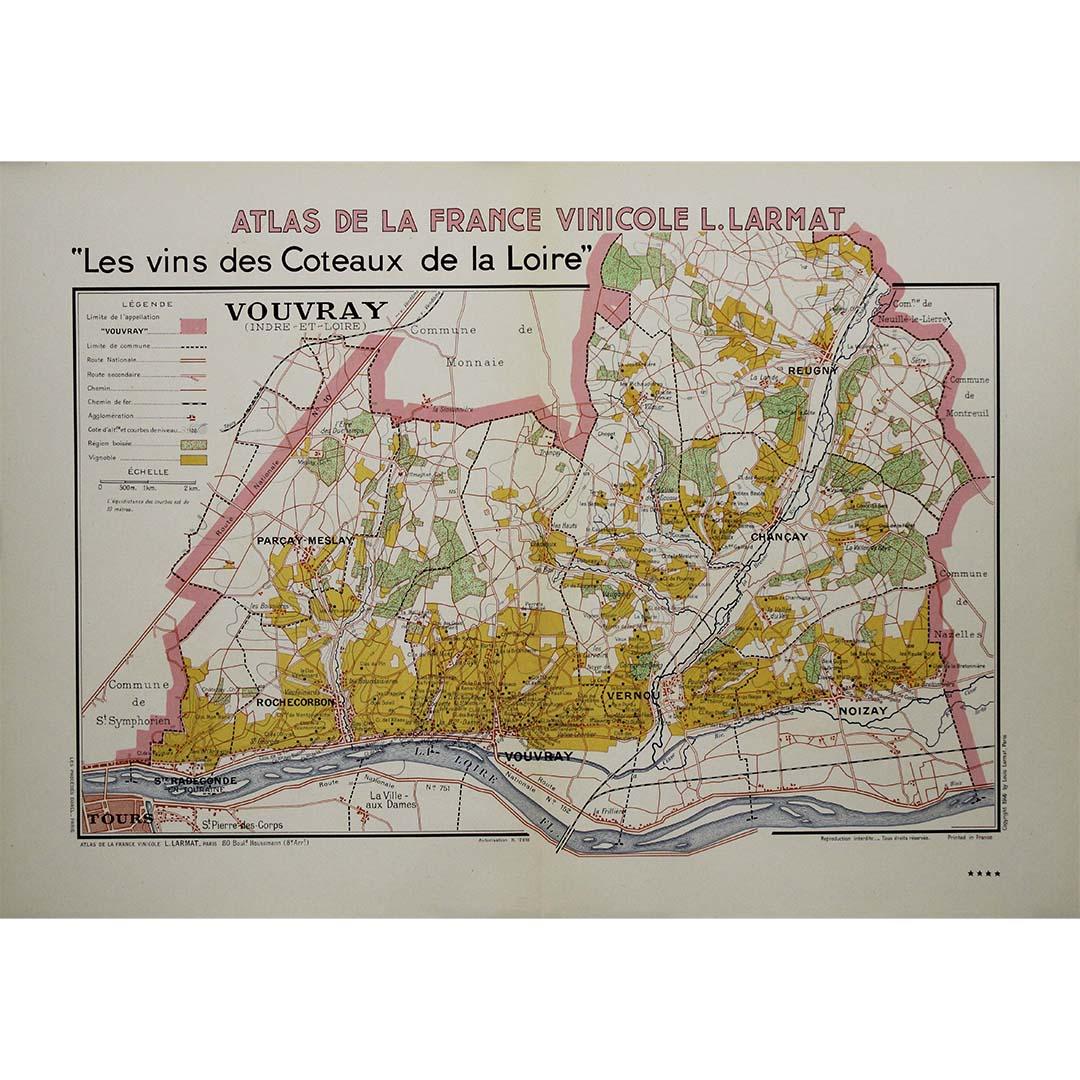
View All1946 original map "Les vins des côteaux de la Loire - Vouvray " by Larmat
Located in PARIS, FR
The 1946 map titled Atlas de la France Vinicole - Les Vins des Côteaux de la Loire: Vouvray by Louis Larmat, printed by Dorel in Paris, presents an intimate exploration of one of the...
Category
1940s Prints and Multiples
Materials
Lithograph, Paper

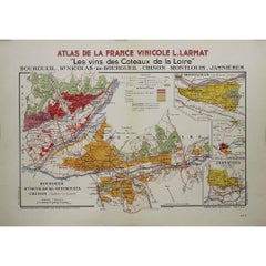
1946 original map "Les vins des côteaux de la Loire - Bourgueil" by Larmat
Located in PARIS, FR
The 1946 original map Atlas de la France Vinicole - Les Vins des Côteaux de la Loire: Bourgueil, St Nicolas-de-Bourgueil, Chinon, Montlouis, Jasnières, created by Louis Larmat and pr...
Category
1940s Prints and Multiples
Materials
Lithograph, Paper
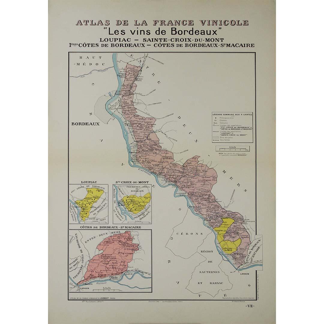
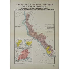
1941 original map "Les vins de Bordeaux - Loupiac, ..." by Larmat
Located in PARIS, FR
In 1941, L. Larmat crafted an exquisite map titled Atlas de la France Vinicole: Les Vins de Bordeaux - Loupiac, Sainte-Croix-du-Mont, Ières Côtes de Bordeaux, Côtes de Bordeaux St. M...
Category
1940s Prints and Multiples
Materials
Lithograph, Paper
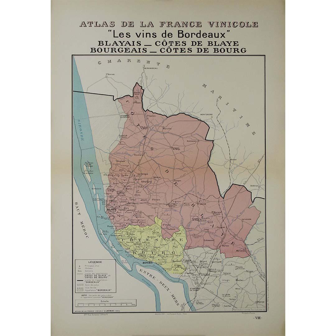
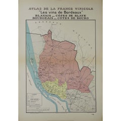
1941 original map "Les vins de Bordeaux - Blayais, Côtes de Blaye" by Larmat
Located in PARIS, FR
In 1941, L. Larmat created an impressive map titled Atlas de la France Vinicole: Les Vins de Bordeaux - Blayais, Côtes de Blaye, Bourgeais, Côtes de Bourg, printed by Dorel in Paris....
Category
1940s Prints and Multiples
Materials
Lithograph, Paper
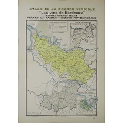
1941 original map "Les vins de Bordeaux - Entre-deux-mers, Graves... " by Larmat
Located in PARIS, FR
In 1941, French cartographer L. Larmat created a remarkable map titled Atlas de la France Vinicole: Les Vins de Bordeaux - Entre-Deux-Mers, Graves de Vayres, Sainte-Foy Bordeaux, whi...
Category
1940s Prints and Multiples
Materials
Lithograph, Paper
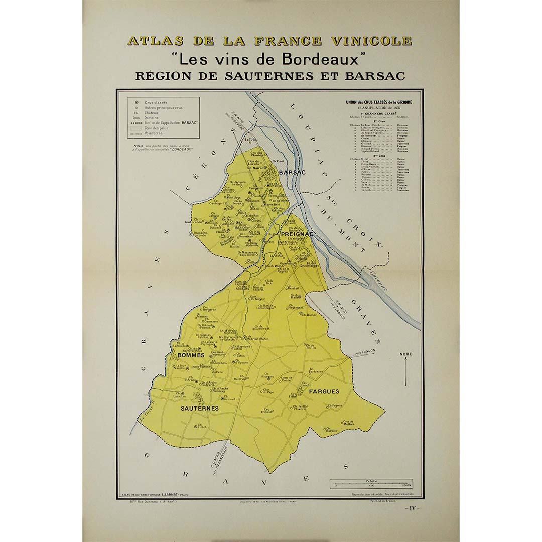
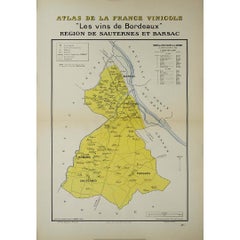
1941 original map "Les vins de Bordeaux - Régions de Sauternes" by Larmat
Located in PARIS, FR
The 1941 original map by L. Larmat, titled "Atlas de la France vinicole – Les vins de Bordeaux: Régions de Sauternes et Barsac", provides an intricate and precise depiction of two of...
Category
1940s Prints and Multiples
Materials
Lithograph, Paper
You May Also Like
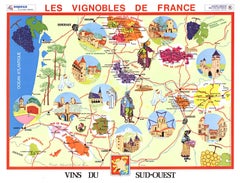
Original Vins du Sud-Ouest vintage French wine map poster
Located in Spokane, WA
Original Les Vignobles de France , Vins du Sud-Quest French vintage wine map poster. Horizontal. Size 36.5" x 27". Archival linen backed and re...
Category
Late 20th Century American Modern Landscape Prints
Materials
Lithograph
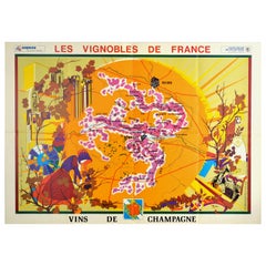
Original Vintage Poster Vineyards Of Champagne Wine Map Les Vignobles De France
Located in London, GB
Original vintage advertising poster for Les Vignobles de France Vins de Champagne / The Vineyards of France Wines of Champagne featuring a pictogra...
Category
Vintage 1960s French Posters
Materials
Paper
Original Vintage Poster Vignobles De France Vins Du Val De Loire Valley Wine Map
Located in London, GB
Original vintage drink advertising poster promoting French wines (one of a series issued by the Comite National de Propagande en Faveur du Vin national committee for the promotion of...
Category
Vintage 1950s French Posters
Materials
Paper
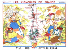
Original Vins Des Côtes du Rhône, French Wine Map vintage poster
Located in Spokane, WA
Original Les Vignobles de France - Cote du Rhone vintage wine map poster. Horizontal. Size 36.5" x 27". Archival linen backed and ready to fram...
Category
Late 20th Century American Modern Landscape Prints
Materials
Lithograph
$600 Sale Price
20% Off
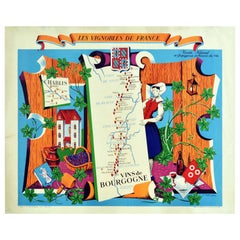
Original Vintage Poster Vignobles De France Vins De Bourgogne Burgundy Wine Map
Located in London, GB
Original vintage drink advertising poster promoting French wines (one of a series issued by the Comite National de Propagande en Faveur du Vin national committee for the promotion of...
Category
Vintage 1950s French Posters
Materials
Paper
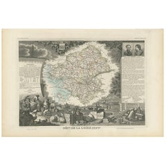
Antique Map of Loire Inferieure ‘France’ by V. Levasseur, 1854
Located in Langweer, NL
Antique map titled 'Dépt. de la Loire Inferieure'. Map of the French department of Loire Inferieure, France (currently known as Loire-Atlantique.) This area of France is part of the ...
Category
Antique Mid-19th Century Maps
Materials
Paper
$189 Sale Price
20% Off
More Ways To Browse
Vintage French Map
Vintage Illustrated Maps
Alcohol Poster
Vintage Alcohol Posters
Wine Map
Treasure Map
Egon Schiele And Max Jaffe
Erotic 1920
Harriet Tubman
Helen Frankenthaler Lincoln Center Posters
Hercules Print
Homage To Andy Warhol
I Have Been To Hell And Back
Iris Lithograph
Japanese Art Print Flower
Jewish Woodcut
Jules Perahim
Kaws Bearbrick