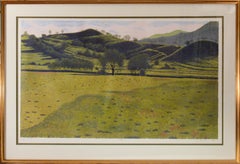
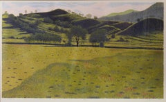
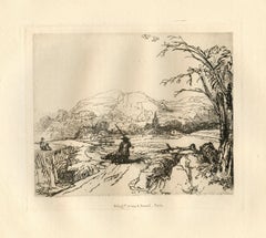
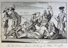
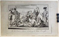
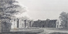
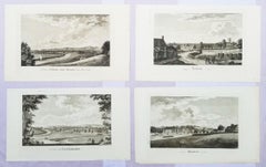
Thomas Kitchin Prints and Multiples

to
1
Overall Width
to
Overall Height
to
11
1,351
969
773
758
1
1
1
1
1
1
1
1
1
1
1
Artist: Thomas Kitchin
Map of Oxfordshire coloured 18th century engraving by Thomas Kitchin
By Thomas Kitchin
Located in London, GB
To see our other original maps, scroll down to "More from this Seller" and below it click on "See all from this Seller" - or send us a message if you cannot find the poster you want....
Category

1760s Thomas Kitchin Prints and Multiples

Materials

Engraving

Related Items
China: An Original 18th Century Hand-colored Map by E. Bowen
Located in Alamo, CA
This is an original 18th century hand-colored map entitled "A New & Accurate Map of China, Drawn from Surveys made by the Jesuit Missionaries, by order of the Emperor. The whole bein...
Category

Mid-18th Century Old Masters Thomas Kitchin Prints and Multiples

Materials

Engraving

Siberia as Explored by Behring: Original 18th Century Hand-colored Map by Bowen
Located in Alamo, CA
This is an original 18th century hand-colored map entitled "An Exact Chart of all the Countries through which Capt. Behring Travelled from Tobolski, Capital of Siberia to the Country...
Category

Mid-18th Century Old Masters Thomas Kitchin Prints and Multiples

Materials

Engraving

Ulysses Deriding Polyphemus: A Framed 19th C. Engraving After J. M. W. Turner
By J.M.W. Turner
Located in Alamo, CA
This beautiful 19th century framed hand-colored engraving/etching entitled "Ullyses Deriding Polyphemus" by Edward Goodall is based on an original 1829 painting by the renowned Briti...
Category

Mid-19th Century Romantic Thomas Kitchin Prints and Multiples

Materials

Engraving, Etching

Pacific Ocean Currents, Handmade Cyanotype Seascape in Blue, Waves Landscape
By Kind of Cyan
Located in Barcelona, ES
This is an exclusive handprinted limited edition cyanotype. "Pacific Ocean Currents" is a handmade cyanotype print of rough water texture resembling Pacific Ocean swell. Details: + ...
Category

2010s Realist Thomas Kitchin Prints and Multiples

Materials

Emulsion, Engraving, Etching, Paper

Map of the Russian Empire: An Original 18th Century Hand-colored Map by E. Bowen
Located in Alamo, CA
This is an original 18th century hand-colored map entitled "A New & Accurate Map of The Whole Russian Empire, As Contain'd Both In Europe and Asia, Drawn from Authentic Journals, Sur...
Category

Mid-18th Century Old Masters Thomas Kitchin Prints and Multiples

Materials

Engraving

A View of Scarborough, England: A Framed 19th C. Engraving After J. M. W. Turner
By J.M.W. Turner
Located in Alamo, CA
This beautiful 19th century framed engraving "Scarborough" by W. Chapman is based on an original painting by the renowned British artist J.M.W. Turner. It was published in London by ...
Category

Mid-19th Century Romantic Thomas Kitchin Prints and Multiples

Materials

Engraving

St. Michael's Mount, Cornwall: A Framed 19th C. Engraving After Myles Foster
By Myles Birket Foster
Located in Alamo, CA
This beautiful 19th century framed hand-colored engraving is entitled "St. Michael's Mount, Cornwall" by J. Saddler after an original painting by the British artist Myles Birket Fost...
Category

Mid-19th Century Romantic Thomas Kitchin Prints and Multiples

Materials

Engraving

Map of the World: An Original 18th Century Hand-colored Map by E. Bowen
Located in Alamo, CA
This is an original 18th century hand-colored map entitled "A New & Correct Chart of All The Known World Laid down according to Mercator's Projection" by Emanuel Bowen. It was published in 1744 in London in John Harris's "Navigantium atque Itinerantium Bibliotheca" or "A Complete Collection of Voyages and Travels". This highly detailed and colorful map depicts the world. as it was known in the mid 18th century. A majority of the northern and central portions of Canada and America are left blank due to the purity of knowledge at the time this map was published. The map is embellished with four Compass Roses in the lower left, lower center, lower right and center, along with many rhumb lines. There a is a decorative title cartouche in the upper left. This colorful, attractive, historical and interesting 1744 map presents the entire world on Mercator's projection as it was understood in the middle part of the 18th century, before the landmark explorations of Captain’s Cook, Vancouver, Wilkes and others. It is an example of a nautical chart, a type of map that was designed specifically for use by mariners. The map is centered on the equator and includes both the Eastern and Western Hemispheres. The continents of North America, South America, Europe, Africa, and Asia are depicted, as well as various islands in the Atlantic, Pacific, and Indian Oceans. The map is laid out according to the Mercator projection, a type of cylindrical map projection that was developed in the 16th century by Flemish cartographer Gerardus Mercator. This projection has the advantage of preserving angles and shapes, making it useful for navigation. The map presents a paucity of inland detail, particularly for the Americas, but major cities, geographical landmarks, and regions are included. Ocean currents and Tradewinds are identified, as well as the magnetic declination lines or magnetic variance, which refers to the difference between true north and compass north. The continents are color coded, enhancing the beauty of this map. The three compass roses indicate the directions of the cardinal points. The depiction of the western coast of America, the Pacific and Australia are interesting. There was very little exploration of Australia between the navigations of William Damper in 1699 and Tobias Furneaux in 1773. Most of the maps detail relies on the 17th century Dutch expeditions to Australia's western coast, by Abel Tasman and William Janszoon. Van Diemen's Land (Tasmania) and New Guinea appear connected to the Australian continent. New Zealand appears as a single landmass. North of New Zealand there is a landmass labelled 'Ter d' St. Esprit' which probably represents the New Hebrides Islands. This map precedes the accurate exploration of the South Pacific and east coast of Australia by Captain James Cook later in the 18th century. The map includes ‘Drakes' Port,' the site where Sir Francis Drake supposedly landed in 1579 during his 1579 circumnavigation of the globe. Here he claimed territory for England, restocked, and repaired his vessels. Drake named the region New Albion. The exact location of Drake's Port is a cartographic mystery. Drake's Harbor is believed to be in the region of San Francisco Bay, Bodega Bay, San Pablo Bay...
Category

Mid-18th Century Old Masters Thomas Kitchin Prints and Multiples

Materials

Engraving

Coentes Slip, NY
By Frederick Leo Hunter
Located in Middletown, NY
Etching with drypoint on hand made laid Japan paper with a deckle edge, 8 9/16 x 11 5/8 inches (220 x 296 mm), full margins. Signed, dated and titled in pencil in the margin, recto. ...
Category

Late 19th Century Victorian Thomas Kitchin Prints and Multiples

Materials

Handmade Paper, Laid Paper, Drypoint, Etching

View of Meissen, Germany: A 16th Century Hand-colored Map by Braun & Hogenberg
By Franz Hogenberg
Located in Alamo, CA
This is a 16th century original hand-colored copperplate engraved map of View of View of Meissen, Germany entitled "Misena Hermun Duvorum Urbs" by Georg Braun & Franz Hogenberg, from their famous city atlas "Civitates Orbis Terrarum", published in Cologne, Germany in 1575. The map depicts a side view and bird's-eye view, looking across the Elbe River (labelled Albis Fluvius on the map; White River in Latin) from the northeast. In the foreground are three women in conversation on a hill above the city, along with a man and a woman in conversation by a road, all dressed in contemporary costumes of the upper class. A coat-of-arms is present in each upper corner. A great castle sits atop a hill in the background on the left. Meissen grew up around Albrechtsburg castle, built by Emperor Henry I around AD 929, and was granted a municipal charter at the end of the 12th century. From 1471 onwards, the castle complex was reconstructed as the residence of the Saxon electors on the northeast corner of the Domberg (Cathedral Hill). Meissen cathedral is a Gothic hall church begun c. 1270; in 1413 a bolt of lightning destroyed its west towers, which were replaced only in the 20th century. Meissen lies to the northwest of Dresden, Germany in Saxony. Meissen is famous for its Meissen porcelain and the Albrechtsburg castle The following is an English translation of an excerpt from Braun's description of the city:  "This city is surrounded by very many rivers, to the east flows the Elbe, to the south the Triebisch, to the west are the mountains, to the north the Meisse, after which the city is said to be named. The city is well-situated in its surroundings, the navigable rivers, the mountains and the healthy air. Around the city there is a good land to grow grain, fertile vineyards on the hillsides and without doubt the mountains are not without ore, for one mile away, up the Elbe, is Scharfenberg, where silver and lead ore are mined.." 
  References: Van der Krogt 4, 2684; Taschen, Braun and Hogenberg...
Category

16th Century Old Masters Thomas Kitchin Prints and Multiples

Materials

Engraving

Bermuda: An Early 17th Century Hand-colored Map by Henricus Hondius
By Henricus Hondius
Located in Alamo, CA
This attractive and interesting map of Bermuda by Henricus Hondius in 1633 is entitled "Mappa Aestivarum Insularum, Alias Barmudas". It is based on a ...
Category

Early 17th Century Old Masters Thomas Kitchin Prints and Multiples

Materials

Engraving

"Coastal Ti Tree" Gums NSW Drypoint Etching in Ink on Paper No. 30/100
Located in Soquel, CA
"Coastal Ti Tree" Drypoint Etching in Ink on Paper No. 30/100 Detailed etching attributed to Ernest Edwin Abbot (British, 1888-1973). Several trees grow along the coast at the edge of the water at Ti Tree, Australia. In the far distance, a mountain range can be seen on the opposite shore. Titled and numbered "Coastal Ti Tree 30-100" in the left corner. Signed "G. Cope" in the right corner. Presented in a new black mat with foamcore backing. Mat size: 11"H x 14"W Paper size: 5.5"H x 10.25"W According to The Centre for Australian Art: Prints + Printmaking, Abbot often produced work under the pseudonym "G. Cope" Ernest Edwin Abbott was born in 1889 and grew up in Bideford United Kingdom, With his younger siblings Violet, Reginald, Olive and his parents Charles and Sarah Abbott, His Farther worked as a upholsterer. Abbott decided in 1911 to migrate to Western Australia on the ship Tainui, Settled in Western Australia he then married his wife Florence Radcliffe Olde in 1913 whom also came to Australia in 1912 from Bideford. They had two sons, Reginald Douglas Abbott and Kenneth John Abbott. They moved to South Australia where he taught art at Stott’s for four years. Later in 1920 the family moved to the suburb of Kew in Melbourne Victoria, where he took a studio in Oxford Chambers at 475 Bourke Street. He also built a studio later at his home in Black Rock. In about 1920 or 1930 he took up dry-point etching, and gave up his city studio to concentrate on printmaking at his home. Abbott made his own engraving tools...
Category

Early 20th Century Naturalistic Thomas Kitchin Prints and Multiples

Materials

Paper, Ink, Drypoint

Previously Available Items
Antique British Map - American Revolution 1782
By Thomas Kitchin
Located in Houston, TX
Unique, antique British copper engraving of America during the War of Independence by Royal Cartographer, Thomas Kitchin, 1782. Contains a multitude of fascinating facts: Indians, forts, early royal grants, boundaries. Map is an original antique, not a reproduction. Original antique map displayed...
Category

18th Century and Earlier Thomas Kitchin Prints and Multiples

Materials

Ink, Paper, Watercolor

Thomas Kitchin prints and multiples for sale on 1stDibs.

Find a wide variety of authentic Thomas Kitchin prints and multiples available for sale on 1stDibs. You can also browse by medium to find art by Thomas Kitchin in engraving and more. Not every interior allows for large Thomas Kitchin prints and multiples, so small editions measuring 22 inches across are available. Customers who are interested in this artist might also find the work of Oliver Hall, R.A., R.E., R.S.W., Simon Tozer, and Gordon Hunt. Thomas Kitchin prints and multiples prices can differ depending upon medium, time period and other attributes. On 1stDibs, the price for these items starts at $223 and tops out at $223, while the average work can sell for $223.

Recently Viewed

View All