Whitehall Antiques Maps
to
2
2
2
2
2
1
1
2
2
2
1
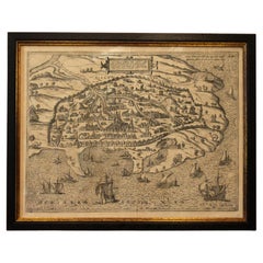
1597 German Map of Alexandria by Georg Braun and Frans Hogenberg
By Georg Braun and Frans Hogenberg
Located in Chapel Hill, NC
1597 Map of Alexandria by Georg Braun and Frans Hogenberg, Germany. From "Civitas Orbis Terrarum", part 2, published in Cologne by Bertram Buchholz. Printed in 2 parts. Title: "Alexa...
Category
Antique 16th Century German Renaissance Maps
Materials
Paper
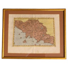
1562 Map of Toscana Nuova Tavola by Girolamo Ruscelli
Located in Chapel Hill, NC
A 1562 map of Toscana Nuova Tavola by Girolamo Ruscelli. Tuscany is the heart of Italy & birthplace of the Italian language. Early hand-coloring. Copper plate engraving. Interestingl...
Category
Antique 16th Century Italian Renaissance Maps
Materials
Paper
Related Items
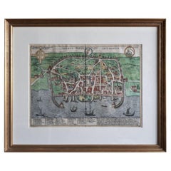
Antique Map of the City of Visby 'Sweden' by F. Hogenberg, 1598
Located in Langweer, NL
This is a wonderful bird's-eye plan/view of the oldest city in Sweden.
Visby, the largest city on the island of Gotland was an important Viking city and the main centre of the Hanseatic League...
Category
Antique 16th Century Maps
Materials
Paper
$2,323 Sale Price
20% Off
H 23.04 in W 27.96 in D 0.99 in
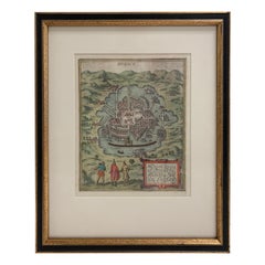
Mexico City by Braun & Hogenberg c. 1590
By Georg Braun and Frans Hogenberg
Located in Stamford, CT
Mexico by Braun & Hogenberg c. 1590
Category
Antique Mid-19th Century European Spanish Colonial Maps
Materials
Glass, Wood, Paper
Antique Map of the City of Dordrecht by Braun & Hogenberg, c.1581
Located in Langweer, NL
Antique map titled 'Dordrecht'. Map of the city of Dordrecht, the Netherlands. Bird's-eye plan view of the city, with many ships and two coats of arms in upper corners. This map orig...
Category
Antique 16th Century Maps
Materials
Paper
$398 Sale Price
20% Off
H 15.16 in W 20.08 in D 0 in
Rare 1572 Map of Ancient Rome with Monuments by Ligorio, Braun & Hogenberg
Located in Langweer, NL
Rare 1572 Map of Ancient Rome with Monuments by Ligorio, Braun & Hogenberg
This remarkable 16th-century map, *Urbis Romae Situs cum ils quae adhuc Conspiciuntur Veter. Monumet Rel...
Category
Antique 16th Century Maps
Materials
Paper
$2,261
H 16.62 in W 21.86 in D 0.01 in
Antique Map of Italy by Lapie, 1842
Located in Langweer, NL
Antique map titled 'Carte de l'Italie Ancienne'. Map of Italy. This map originates from 'Atlas universel de géographie ancienne et moderne (..)' by Pierre...
Category
Antique Mid-19th Century Maps
Materials
Paper
Antique Print of Liège / Luik in Belgium by Braun & Hogenberg, 1575
Located in Langweer, NL
Antique print titled 'Leodium'. View of Liège / Luik, Belgium with surrounding hills and the city wall. With text explaining the origins of Liège, a cartouche expressing thanks to th...
Category
Antique 16th Century Prints
Materials
Paper
$1,276 Sale Price
20% Off
H 15.75 in W 15.56 in D 0 in
Antique Map of Douai 'France' by Braun & Hogenberg, circa 1575
Located in Langweer, NL
Beautiful map in excellent condition. This map depicts the city of Douai (France) and originates from 'Civitates Orbis Terrarum'.
Category
Antique 16th Century Maps
Materials
Paper
Bordeaux City View – Braun & Hogenberg Original Woodcut, ca. 1575
Located in Langweer, NL
Bordeaux City View – Braun & Hogenberg Original Woodcut, ca. 1575
Description:
This detailed and highly decorative bird’s-eye view of Bordeaux, titled Bovrdeavx, originates from the...
Category
Antique 16th Century German Maps
Materials
Paper
Palermo – 1620 Braun & Hogenberg Bird’s-Eye Map of Palermo, Sicily
Located in Langweer, NL
Palermo – 1620 Braun & Hogenberg Bird’s-Eye Map of Palermo, Sicily
This beautifully detailed bird’s-eye view of Palermo, Sicily, was created by Georg Braun and Frans Hogenberg aro...
Category
Antique 1620s Maps
Materials
Paper
$1,666
H 12.8 in W 19.61 in D 0.01 in
Map of Italy and Neighboring Regions by Delamarche – Antique Map, c.1800
Located in Langweer, NL
Antique Map of Italy and Surrounding Regions by Delamarche, circa 1800
This elegant and detailed antique map titled Carte Générale de l’Italie was drawn and engraved by the French g...
Category
Antique Early 1800s French Maps
Materials
Paper
$678
H 22.45 in W 31.7 in D 0.01 in
Antique Map of France by Lapie, 1842
Located in Langweer, NL
Antique map titled 'Carte des Gaules'. Map of France. This map originates from 'Atlas universel de géographie ancienne et moderne (..)' by Pierre M. Lapie and Alexandre E. Lapie. Pie...
Category
Antique Mid-19th Century Maps
Materials
Paper
Bird’s-Eye View of Basel from Braun & Hogenberg’s Civitates Orbis Terrarum, 1575
Located in Langweer, NL
Bird’s-Eye View of Basel from Braun & Hogenberg’s "Civitates Orbis Terrarum" (Circa 1572-1617)
This highly detailed map of Basel is a bird's-eye view, originally based on Sebastian Münster’s map...
Category
Antique 16th Century Maps
Materials
Paper
$1,137 Sale Price
20% Off
H 16.15 in W 21.26 in D 0 in


