Items Similar to 1597 German Map of Alexandria by Georg Braun and Frans Hogenberg

Want more images or videos?
Request additional images or videos from the seller
1 of 7
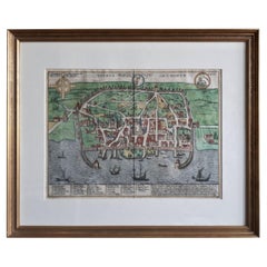
1597 German Map of Alexandria by Georg Braun and Frans Hogenberg
$600
£458.73
€528.37
CA$840.78
A$938.66
CHF 491.84
MX$11,490.07
NOK 6,246.40
SEK 5,889.56
DKK 3,943.25
Shipping
Retrieving quote...The 1stDibs Promise:
Authenticity Guarantee,
Money-Back Guarantee,
24-Hour Cancellation
About the Item
1597 Map of Alexandria by Georg Braun and Frans Hogenberg, Germany. From "Civitas Orbis Terrarum", part 2, published in Cologne by Bertram Buchholz. Printed in 2 parts. Title: "Alexandria, Vetustissimum Aegypti Emporium, Amplissima Civitas". Reference: Van der Krogt, 4, 41:1-2. Overall good condition with some wrinkling & light coloring. Double glazed frame with a back page exposed. Impression size: 14 7/16" x 19 1/8".
Frame: 17.75" x 22.25"
We are a family business that has been a major source for the selective buyer for over 90 years. We are one the finest antiques shop in the South and Mid-Atlantic, proclaimed the “Best Antiques Shop in the Mid-Atlantic” by Mid-Atlantic Antiques Magazine. With over 7,500 square feet of show room space in an impressive Italianate Villa setting, we are a must visit spot for antiques collectors, dealers and decorators alike!
We specialize in period 18th and 19th century English and Country French furniture, fine art, silver, porcelain, lighting, and all appropriate decorative accessories. You will also find pieces of American origin, from Continental Europe, Asia, and the Middle East and ranging in date and style from Baroque to Mid-Century Modern. In short, we are a treasure trove of unique items with an unprecedented selection for your home or collection!
- Creator:Georg Braun and Frans Hogenberg (Artist)
- Dimensions:Height: 22.25 in (56.52 cm)Width: 17.75 in (45.09 cm)Depth: 1 in (2.54 cm)
- Style:Renaissance (Of the Period)
- Materials and Techniques:
- Place of Origin:
- Period:
- Date of Manufacture:1597
- Condition:Wear consistent with age and use.
- Seller Location:Chapel Hill, NC
- Reference Number:Seller: WP-2533z1stDibs: LU6458241944132
About the Seller
4.9
Platinum Seller
Premium sellers with a 4.7+ rating and 24-hour response times
Established in 1930
1stDibs seller since 2022
322 sales on 1stDibs
Typical response time: 1 hour
- ShippingRetrieving quote...Shipping from: Chapel Hill, NC
- Return Policy
Authenticity Guarantee
In the unlikely event there’s an issue with an item’s authenticity, contact us within 1 year for a full refund. DetailsMoney-Back Guarantee
If your item is not as described, is damaged in transit, or does not arrive, contact us within 7 days for a full refund. Details24-Hour Cancellation
You have a 24-hour grace period in which to reconsider your purchase, with no questions asked.Vetted Professional Sellers
Our world-class sellers must adhere to strict standards for service and quality, maintaining the integrity of our listings.Price-Match Guarantee
If you find that a seller listed the same item for a lower price elsewhere, we’ll match it.Trusted Global Delivery
Our best-in-class carrier network provides specialized shipping options worldwide, including custom delivery.More From This Seller
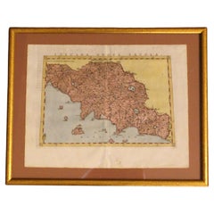
View All1562 Map of Toscana Nuova Tavola by Girolamo Ruscelli
Located in Chapel Hill, NC
A 1562 map of Toscana Nuova Tavola by Girolamo Ruscelli. Tuscany is the heart of Italy & birthplace of the Italian language. Early hand-coloring. Copper plate engraving. Interestingl...
Category
Antique 16th Century Italian Renaissance Maps
Materials
Paper
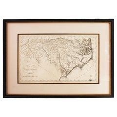
1796 Map of North Carolina by John Reid
Located in Chapel Hill, NC
1796 Map of North Carolina by John Reid. A rare & important early map of the state based on the 1795 Lewis/Carey map for his "An American Atlas". Engraved by Benjamin Tanner. Old pur...
Category
Antique Late 18th Century American Prints
Materials
Paper
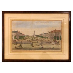
1752 "A View of Amsterdam" Print From George Balthasar Probst Lithograph
By Georg Balthasar Probst
Located in Chapel Hill, NC
A View of Amsterdam taken from the Old Rampart print published April 10, 1752, English. Published according to Act of Parliament. Old hand coloring. From the George Balthasar Probst ...
Category
Antique Mid-18th Century English Neoclassical Prints
Materials
Paper
Early 19th Century Engraving "Luglio" from The Months by Giuseppe Zocchi
By Francesco Bartolozzi
Located in Chapel Hill, NC
Early 19th century engraving "Luglio" from The Months by Giuseppe Zocchi, Italian. Engraved by Francesco Bartolozzi, Italian, 1727-1815. Zocchi, 1711-1767. Hand colored. A celebratio...
Category
Antique Early 19th Century Italian Romantic Prints
Materials
Paper
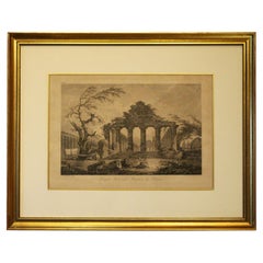
Late 18th Century French Print "Temple Herastyle Périptère de Pestum"
Located in Chapel Hill, NC
Late 18th century print "Temple Herastyle Périptère de Pestum", French. No 381, G.G., Gravé à L'eau-forte par Weisbret. Terminé par J. Miamet graveur du Roi. From "Voyage Pittoresque...
Category
Antique Late 18th Century French Neoclassical Prints
Materials
Paper
Late 18th-Early 19th Century Continental Landscape Painting
Located in Chapel Hill, NC
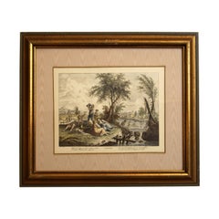
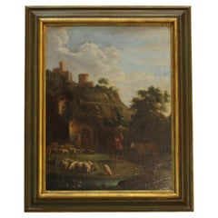
Late 18th-early 19th century capriccio (imaginary) landscape, Continental. A shepherd & animals at hillside "barns" below Italianate church & fortress. Acquired in the late 1940s by ...
Category
Antique Early 19th Century European Romantic Paintings
Materials
Canvas
You May Also Like
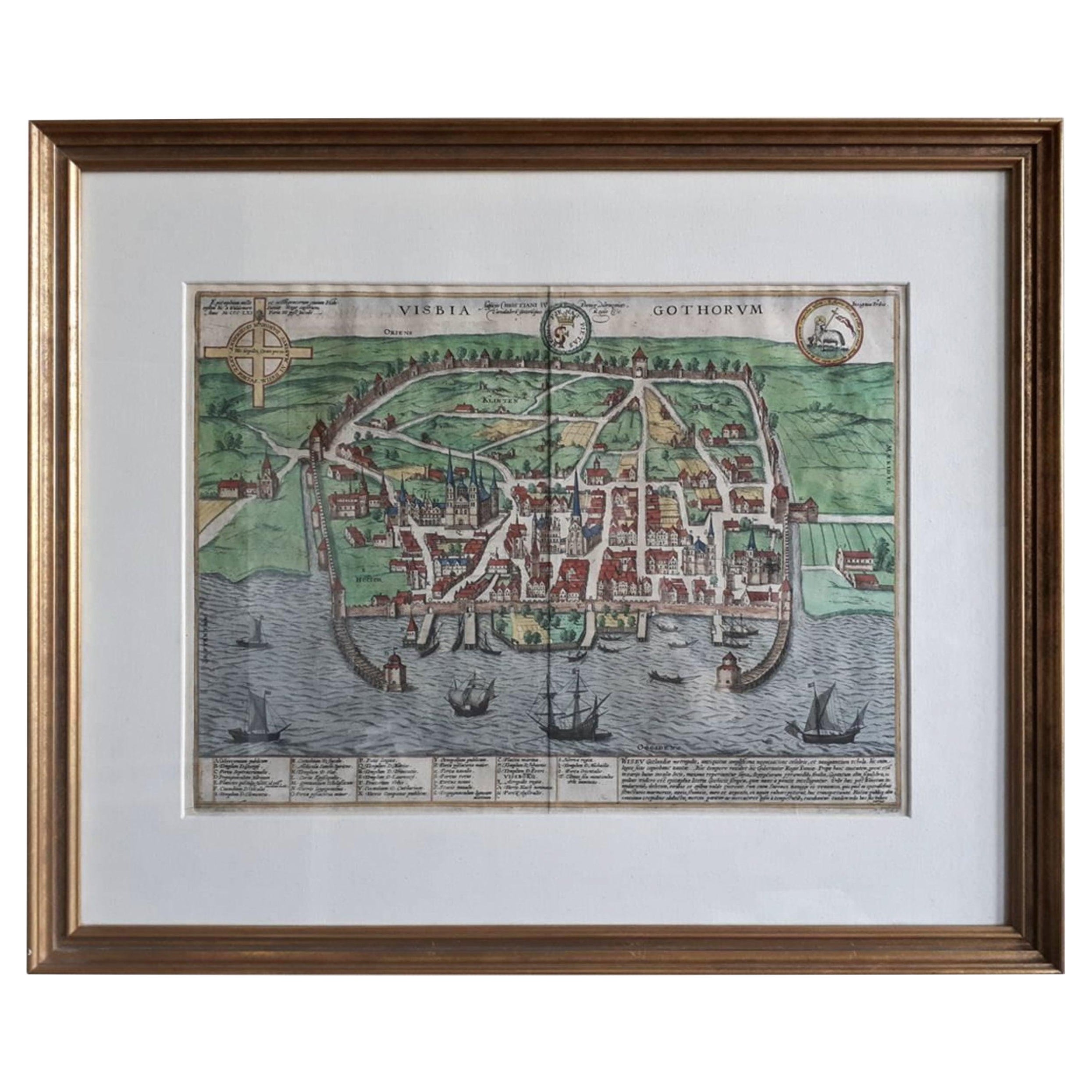
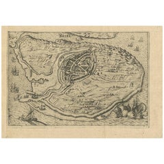
Antique Map of the City of Visby 'Sweden' by F. Hogenberg, 1598
Located in Langweer, NL
This is a wonderful bird's-eye plan/view of the oldest city in Sweden.
Visby, the largest city on the island of Gotland was an important Viking city and the main centre of the Hanseatic League...
Category
Antique 16th Century Maps
Materials
Paper
$2,315 Sale Price
20% Off
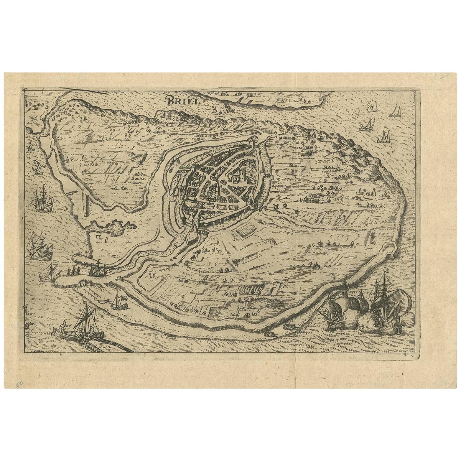
Antique Map of the City of Brielle 'The Netherlands' by L. Guicciardini, 1625
Located in Langweer, NL
Plan of Brielle, Briel, Den Briel in the Province of Zuid-Holland, The Netherlands, Holland. This map originates from the 1625 edition of 'Discrittione di tutti i Paesi Bassi', by L....
Category
Antique Early 17th Century Maps
Materials
Paper
$170 Sale Price
20% Off
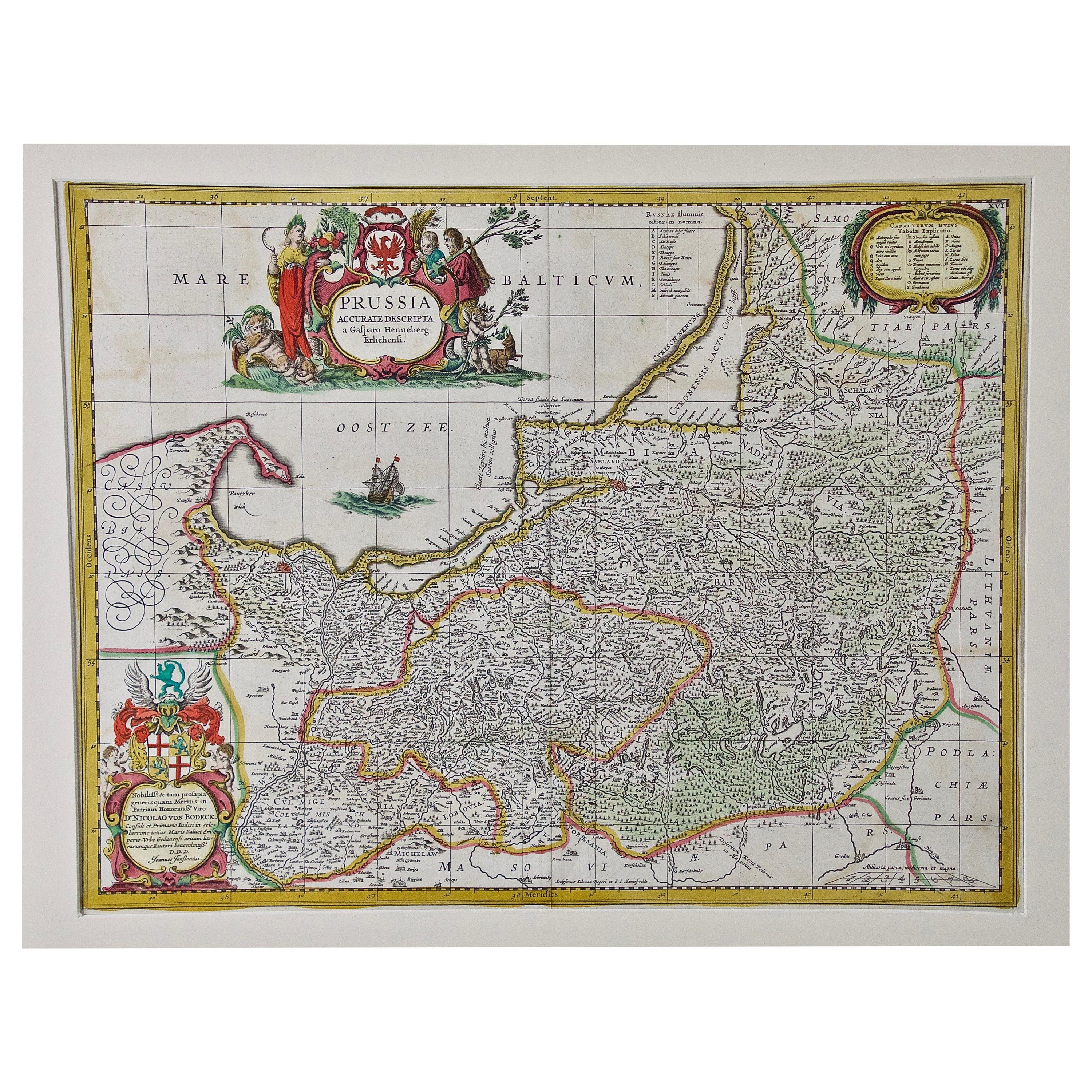
Prussia, Poland, N. Germany, Etc: A Hand-colored 17th Century Map by Janssonius
By Johannes Janssonius
Located in Alamo, CA
This is an attractive hand-colored copperplate engraved 17th century map of Prussia entitled "Prussia Accurate Descripta a Gasparo Henneberg Erlichensi", published in Amsterdam by Joannes Janssonius in 1664. This very detailed map from the golden age of Dutch cartography includes present-day Poland, Latvia, Lithuania, Estonia and portions of Germany. This highly detailed map is embellished by three ornate pink, red, mint green and gold...
Category
Antique Mid-17th Century Dutch Maps
Materials
Paper

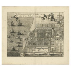
Rare 1681 Map of Batavia: Detailed Dutch Colonial Era Cartography, 1681
Located in Langweer, NL
The map of Batavia (modern-day Jakarta) from 1681, attributed to Frederick de Wit holds significant historical importance for several reasons:
Historical Context
1. Colonial Era: This map dates back to the Dutch colonial era when Batavia served as the administrative and commercial hub of the Dutch East India Company (VOC). The VOC was a powerful trading entity that played a crucial role in the global spice trade and colonization in Southeast Asia.
2. Strategic Importance: Batavia was strategically located on the northwestern coast of Java, providing the Dutch with a critical base for their maritime operations. The city became the center of Dutch political and military control in the region.
Cartographic Significance
1. Detailed Urban Layout: The map meticulously details the layout of Batavia, including its fortifications, canals, streets, and significant buildings. This level of detail provides insights into the urban planning and architectural styles of the period.
2. Military Engineering: The fortifications shown on the map illustrate the advanced military engineering techniques used by the Dutch to protect their valuable colony. The walls, bastions, and moats indicate the strategic considerations taken to defend against potential invasions.
3. Maritime Activity: The depiction of ships in the harbor highlights Batavia's role as a major maritime center. The VOC's fleets were essential for trade routes connecting Europe, Africa, and Asia, making Batavia a crucial node in global commerce.
Artistic and Cultural Value
1. Artistic Elements: The decorative elements, such as the lion holding a shield and the intricate cartouches, reflect the artistic trends of Dutch Golden Age cartography. These embellishments were not only informative but also served to display the cartographer's skill and the map's prestige.
2. Cultural Exchange: Maps like this one provide evidence of cultural exchange between the Dutch and the indigenous populations of Java. The blending of Dutch and local influences can be seen in various aspects of the map and the architecture of the city.
Rarity and Preservation
1. Rarity: Maps from the 17th century, especially those in good condition, are relatively rare and highly valued by collectors and historians. Each map provides a unique snapshot of historical geography and urban development.
2. Preservation of History: This map serves as a historical document, preserving knowledge about Batavia's cityscape, infrastructure, and colonial governance. It helps historians and scholars understand the socio-economic and political dynamics of the period.
Conclusion
The map of Batavia from 1681 is special due to its detailed depiction of one of the most important colonial cities in Southeast Asia during the Dutch Golden Age. It reflects the strategic, economic, and cultural significance of Batavia, serving as a valuable resource for understanding the history of Dutch colonialism and its global impact. The map's artistry and precision make it an important artifact in the history of cartography.
---------------
The map is an original and historical map of Batavia (present-day Jakarta) on the island of Java, dated 1681. There are several details to consider when evaluating its origins and possible authorship:
1. **Style and Detail**: The intricate details and style are reminiscent of maps created by Frederick de Wit, a prominent Dutch cartographer and engraver of the 17th century. He was known for his detailed city maps and sea charts.
2. **Lack of Signature**: The absence of "F. de Wit, Excudit" could indicate either an omission or a different engraver. However, it is essential to note that some maps from that period were reproduced or copied by other engravers and cartographers. This was not uncommon, as map-making was a collaborative effort, and copies of popular maps were frequently made.
3. **Map Characteristics**:
- The depiction of ships and the detailed fortifications are typical of Dutch cartography in the late 17th century.
- The decorative elements, such as the lion holding a shield, are also characteristic of Dutch map engravers.
4. **Other Possible Engravers**: While Frederick de Wit is a strong candidate, other notable Dutch engravers from that period include Joan Blaeu and Willem Janszoon Blaeu. They also produced highly detailed maps and could potentially be the creators or inspirers of this map.
To determine the precise authorship, you might consider:
- **Comparing** this map with other confirmed works of Frederick de Wit and his contemporaries to identify stylistic similarities and differences.
- **Historical Records**: Consulting historical records or publications related to Dutch cartography in the 17th century might provide more context or even direct references to this particular map.
If you have access to additional details or higher-resolution images of specific sections, it might help further pinpoint the map's origin and authorship.
-------------
Frederick de Wit (1629–1706) was a prominent Dutch cartographer, engraver, and publisher known for his detailed and decorative maps, atlases, and globes. He played a significant role in the Dutch Golden Age of cartography, contributing to the wealth of geographic knowledge and artistic achievement during this period. Here are key aspects of his life and work:
### Biography
- **Early Life**: Frederick de Wit was born in Gouda, Netherlands, in 1629. Little is known about his early years, but he moved to Amsterdam, the epicenter of Dutch cartography, in the mid-17th century.
- **Career Beginnings**: De Wit began his career as an engraver and publisher, initially producing maps that were reissues of earlier works by other cartographers, such as Joan Blaeu and Willem Janszoon Blaeu.
### Contributions to Cartography
- **Mapmaking**: De Wit was known for his meticulous attention to detail and artistic flair. He produced a wide range of maps, including world maps, regional maps, city plans, and maritime charts...
Category
Antique 1680s Maps
Materials
Paper
$5,576 Sale Price
20% Off
Free Shipping
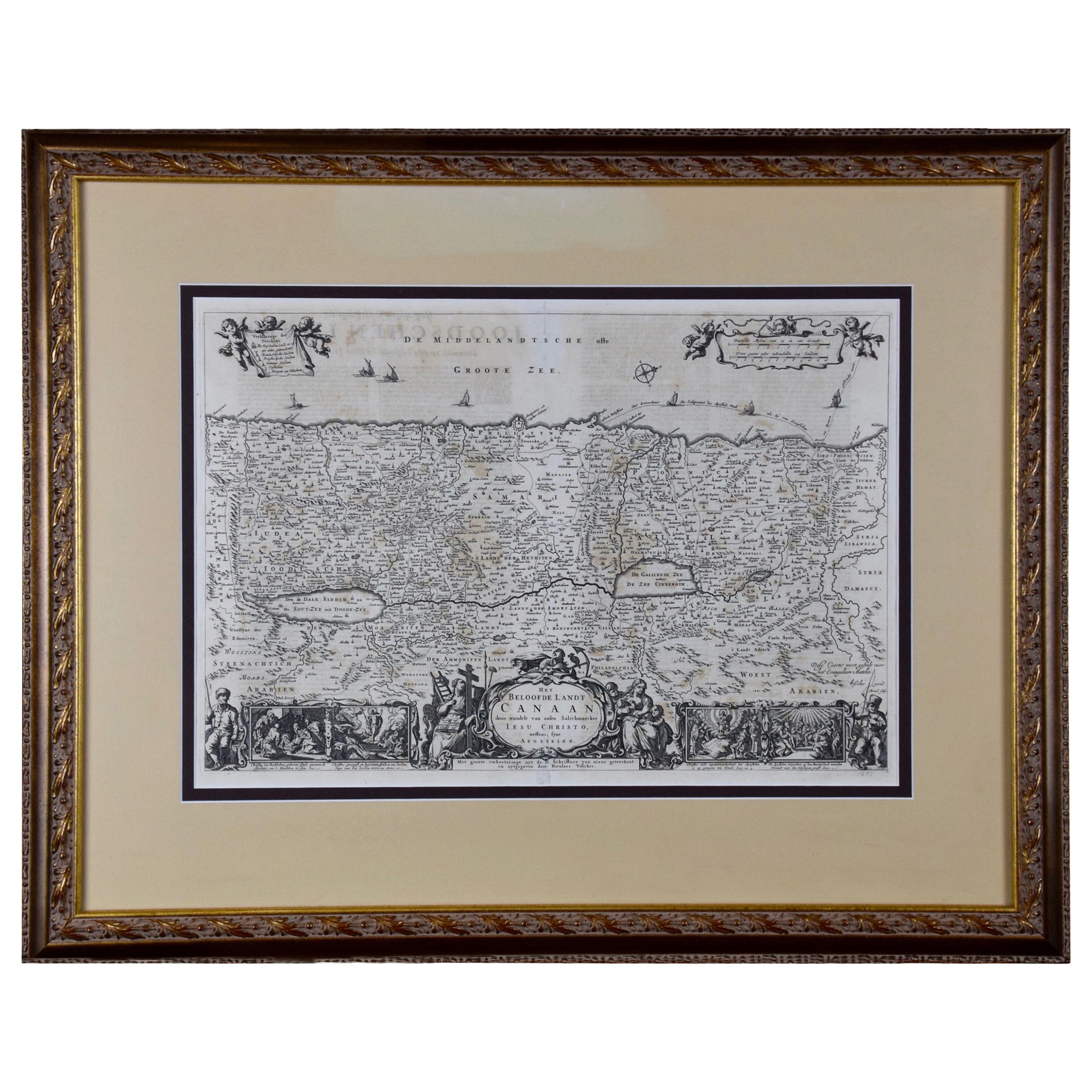
The Holy Land at the Time of Jesus: A 17th Century Dutch Map by Visscher
By Nicolaes Visscher II
Located in Alamo, CA
This detailed Dutch map entitled "Het Beloofe de Landt Canaan door wandelt van onsen Salichmaecker Iesu Christo, nessens syne Apostelen" by Nicolaes Visscher was published in Amsterd...
Category
Antique Mid-17th Century Dutch Maps
Materials
Paper

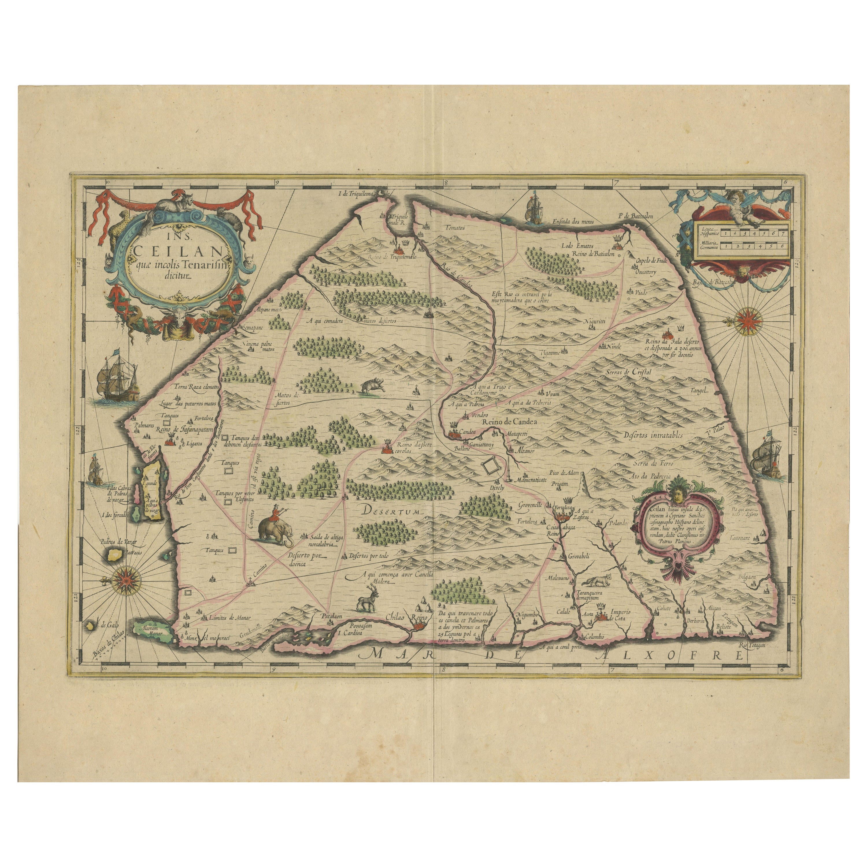
1638 Plancius Detailed Map of Sri Lanka or Ceylon with Decorative Cartouches
Located in Langweer, NL
"1638 Plancius Detailed Map of Sri Lanka with Decorative Cartouches"
This beautifully detailed map of Sri Lanka, titled "Ins. Ceilan," was engraved by P. Plancius from a design by C...
Category
Antique 1630s Maps
Materials
Paper
$1,361 Sale Price
20% Off
More Ways To Browse
German Antique Shops
German Renaissance
19th Century German Collectibles
Silver Emporium
16th Century English Silver
19th Century German Porcelain Collectibles
Coffee Tables Europe
Marble Top Dining Tables
Nordiska Argentina
Pink And Black Rug
Black Wooden Chair
Orrefors Embassy
Black Ebonized
Elios Chair
Panache Designs
Plata Lappas
Red Retro Dining Set
Antique Bouquet