Maps


262
5,425
3
2
to
1,219
5,180
243
5,430
5,430
5,430
57
36
15
11
9
5
5
4
4
3
1
1
1
2,880
2,140
405
5
229
29
8
84
6
57
6
3
3
4
2
2
5,338
111
43
30
30
494
280
165
121
115
104
63
31
26
16
Maps For Sale
Antique Collegiate Map, Cambridge, English, Framed Cartography, Victorian, 1838
Located in Hele, Devon, GB
This is an antique collegiate map of Cambridge. An English, framed coloured lithograph of cartographic interest by Thomas Moule, dating to the early Victorian period, circa 1838.
T...
Category
Early 19th Century British Early Victorian Antique Maps
Materials
Glass, Wood, Paper


Antique Road Map, Bristol to Weymouth, English, Framed Cartography, Georgian
Located in Hele, Devon, GB
This is an antique coaching road map of Bristol to Weymouth. An English, framed lithograph engraving of regional interest with second map to reverse, dating to the mid 18th century ...
Category
Mid-18th Century British George II Antique Maps
Materials
Glass, Wood, Paper

Antique Lithography Map, Warwickshire, English, Framed, Cartography, Victorian
Located in Hele, Devon, GB
This is an antique lithography map of Warwickshire. An English, framed atlas engraving of cartographic interest, dating to the mid 19th century and later.
Superb lithography of War...
Category
Mid-19th Century British Victorian Antique Maps
Materials
Glass, Wood, Paper

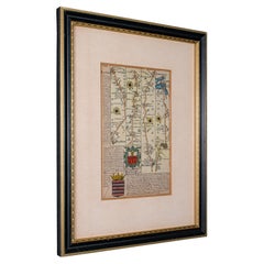
Antique County Map, Hampshire, English, Framed Cartography, Robert Morden, 1700
Located in Hele, Devon, GB
This is an antique county map of Hampshire. An English, framed atlas engraving of cartographic interest By Robert Morden, dating to the late 17th century and later.
Superb lithogra...
Category
Late 17th Century British Other Antique Maps
Materials
Glass, Wood, Paper

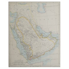
Antique Map of the Arabian Peninsula by Pierre Antoine Tardieu (1784-1869)
Located in Langweer, NL
This is an original antique map titled "Carte de l'Arabie," depicting the Arabian Peninsula and its surrounding regions. Created by Pierre Antoine Tardieu, this map provides a detail...
Category
Early 1800s Antique Maps
Materials
Paper
")
Antique Map of the Northeastern United States and Canada by Tardieu, 1802
Located in Langweer, NL
This antique map titled "Carte de la Partie Septentrionale des Etats Unis," created by Pierre Antoine Tardieu, depicts the northeastern part of the United States and parts of Canada....
Category
Early 1800s Antique Maps
Materials
Paper

Vincenzo Coronelli's Colored Map of the New World Western Hemisphere Framed 47"
Located in Dayton, OH
A Framed Reproduction of Coronelli's Map of the New World, Attributed to Trevor James Company. The map shows the Western Hemisphere including the discoveries made by Abel Tasman in A...
Category
20th Century Maps
Materials
Paper

Map of Denmark, Norway & Iceland: Early 19th Century from the 1802 Tardieu Atlas
Located in Langweer, NL
Antique Map Description
Title: Royaume de Danemarck: Première Carte. Danemarck, Norwege et Islande
Publication Details:
- **Atlas Title:** Nouvel Atlas Universel de Géographie Anc...
Category
Early 1800s Antique Maps
Materials
Paper

Antique Lithography Map, Hampshire, England, Framed Cartography, Victorian, 1850
Located in Hele, Devon, GB
This is an antique lithography map of Hampshire. An English, framed atlas engraving of cartographic interest, dating to the mid 19th century and later.
Superb lithography of Hampsh...
Category
Mid-19th Century British Victorian Antique Maps
Materials
Glass, Wood, Paper

Rare 1681 Map of Batavia: Detailed Dutch Colonial Era Cartography, 1681
Located in Langweer, NL
The map of Batavia (modern-day Jakarta) from 1681, attributed to Frederick de Wit holds significant historical importance for several reasons:
Historical Context
1. Colonial Era: This map dates back to the Dutch colonial era when Batavia served as the administrative and commercial hub of the Dutch East India Company (VOC). The VOC was a powerful trading entity that played a crucial role in the global spice trade and colonization in Southeast Asia.
2. Strategic Importance: Batavia was strategically located on the northwestern coast of Java, providing the Dutch with a critical base for their maritime operations. The city became the center of Dutch political and military control in the region.
Cartographic Significance
1. Detailed Urban Layout: The map meticulously details the layout of Batavia, including its fortifications, canals, streets, and significant buildings. This level of detail provides insights into the urban planning and architectural styles of the period.
2. Military Engineering: The fortifications shown on the map illustrate the advanced military engineering techniques used by the Dutch to protect their valuable colony. The walls, bastions, and moats indicate the strategic considerations taken to defend against potential invasions.
3. Maritime Activity: The depiction of ships in the harbor highlights Batavia's role as a major maritime center. The VOC's fleets were essential for trade routes connecting Europe, Africa, and Asia, making Batavia a crucial node in global commerce.
Artistic and Cultural Value
1. Artistic Elements: The decorative elements, such as the lion holding a shield and the intricate cartouches, reflect the artistic trends of Dutch Golden Age cartography. These embellishments were not only informative but also served to display the cartographer's skill and the map's prestige.
2. Cultural Exchange: Maps like this one provide evidence of cultural exchange between the Dutch and the indigenous populations of Java. The blending of Dutch and local influences can be seen in various aspects of the map and the architecture of the city.
Rarity and Preservation
1. Rarity: Maps from the 17th century, especially those in good condition, are relatively rare and highly valued by collectors and historians. Each map provides a unique snapshot of historical geography and urban development.
2. Preservation of History: This map serves as a historical document, preserving knowledge about Batavia's cityscape, infrastructure, and colonial governance. It helps historians and scholars understand the socio-economic and political dynamics of the period.
Conclusion
The map of Batavia from 1681 is special due to its detailed depiction of one of the most important colonial cities in Southeast Asia during the Dutch Golden Age. It reflects the strategic, economic, and cultural significance of Batavia, serving as a valuable resource for understanding the history of Dutch colonialism and its global impact. The map's artistry and precision make it an important artifact in the history of cartography.
---------------
The map is an original and historical map of Batavia (present-day Jakarta) on the island of Java, dated 1681. There are several details to consider when evaluating its origins and possible authorship:
1. **Style and Detail**: The intricate details and style are reminiscent of maps created by Frederick de Wit, a prominent Dutch cartographer and engraver of the 17th century. He was known for his detailed city maps and sea charts.
2. **Lack of Signature**: The absence of "F. de Wit, Excudit" could indicate either an omission or a different engraver. However, it is essential to note that some maps from that period were reproduced or copied by other engravers and cartographers. This was not uncommon, as map-making was a collaborative effort, and copies of popular maps were frequently made.
3. **Map Characteristics**:
- The depiction of ships and the detailed fortifications are typical of Dutch cartography in the late 17th century.
- The decorative elements, such as the lion holding a shield, are also characteristic of Dutch map engravers.
4. **Other Possible Engravers**: While Frederick de Wit is a strong candidate, other notable Dutch engravers from that period include Joan Blaeu and Willem Janszoon Blaeu. They also produced highly detailed maps and could potentially be the creators or inspirers of this map.
To determine the precise authorship, you might consider:
- **Comparing** this map with other confirmed works of Frederick de Wit and his contemporaries to identify stylistic similarities and differences.
- **Historical Records**: Consulting historical records or publications related to Dutch cartography in the 17th century might provide more context or even direct references to this particular map.
If you have access to additional details or higher-resolution images of specific sections, it might help further pinpoint the map's origin and authorship.
-------------
Frederick de Wit (1629–1706) was a prominent Dutch cartographer, engraver, and publisher known for his detailed and decorative maps, atlases, and globes. He played a significant role in the Dutch Golden Age of cartography, contributing to the wealth of geographic knowledge and artistic achievement during this period. Here are key aspects of his life and work:
### Biography
- **Early Life**: Frederick de Wit was born in Gouda, Netherlands, in 1629. Little is known about his early years, but he moved to Amsterdam, the epicenter of Dutch cartography, in the mid-17th century.
- **Career Beginnings**: De Wit began his career as an engraver and publisher, initially producing maps that were reissues of earlier works by other cartographers, such as Joan Blaeu and Willem Janszoon Blaeu.
### Contributions to Cartography
- **Mapmaking**: De Wit was known for his meticulous attention to detail and artistic flair. He produced a wide range of maps, including world maps, regional maps, city plans, and maritime charts...
Category
1680s Antique Maps
Materials
Paper

Antique Map of the Gulf of Mexico and Caribbean Islands by Tardieu, 1802
Located in Langweer, NL
This is an original antique map titled "Carte du Golfe du Mexique et des Isles Antilles," depicting the Gulf of Mexico and the Caribbean islands. Created by Pierre Antoine Tardieu, t...
Category
Early 1800s Antique Maps
Materials
Paper

Antique Map of South Carolina, North Carolina, and Virginia by Tardieu, 1802
Located in Langweer, NL
This is an original antique map titled "Carte de la Caroline Méridionale et Septentrionale et de la Virginie," depicting the regions of South Carolina, North Carolina, and Virginia i...
Category
Early 1800s Antique Maps
Materials
Paper

Antique Map of Florida and Georgia, Gulf of Mexico, Caribbean Islands, 1802
Located in Langweer, NL
This is an original antique map titled "Carte de la Floride et de la Georgie," depicting the regions of Florida and Georgia in the early 19th century. Created by Pierre Antoine Tardi...
Category
Early 1800s Antique Maps
Materials
Paper

Genuine Antique Map of European Turkey by Pierre Antoine Tardieu (1784-1869)
Located in Langweer, NL
This is an original antique map titled "Carte de la Turquie d'Europe," which depicts the European territories of the Ottoman Empire. The map features detailed geographical and politi...
Category
Early 1800s Antique Maps
Materials
Paper
")
Physical & Political Map of Switzerland: Late 18th Century - Mentelle Atlas
Located in Langweer, NL
Antique Map with Title: 'Carte Physique et Politique de la Suisse'
**Publication Details:**
- **Atlas Title:** Nouvel Atlas Universel de Géographie Ancienne et Moderne
- **Purpose:...
Category
1790s Antique Maps
Materials
Paper

Antique Map of Peloponnesus, Greece by Pierre Antoine Tardieu, 1797
Located in Langweer, NL
This antique map, titled "Carte Ancienne d'Allemagne," represents ancient Germany and surrounding regions. It was published by the well-known Parisian mapmakers and publishers Jean-B...
Category
1790s Antique Maps
Materials
Paper

Antique Map of Northern India, Bengal, and Surrounding Regions by Tardieu, 1802
Located in Langweer, NL
This is an original antique map titled "Inde, Indostan Bengale &c. et Partie Septentrionale de la Presqu'isle en deça du Gange," depicting the northern part of the Indian subcontinen...
Category
Early 1800s Antique Maps
Materials
Paper

Antique Map of Asian Turkey, Levant, and Mesopotamia by Tardieu, circa 1802
Located in Langweer, NL
This is an original antique map titled "Carte de la Turquie Asiatique," depicting the Asian territories of the Ottoman Empire. Created by Pierre Antoine Tardieu, this map illustrates...
Category
Early 1800s Antique Maps
Materials
Paper

Antique Map of the Black Sea and Crimea by Pierre Antoine Tardieu (1784-1869)
Located in Langweer, NL
This is an original antique map titled "Carte de la Mer Noire ou Kara Degniz," depicting the Black Sea region. This map, created by Pierre Antoine Tardieu, highlights the geographica...
Category
Early 1800s Antique Maps
Materials
Paper
")
Historical Map of Ancient Germany (1787): Tribes and Territories by Mentele
Located in Langweer, NL
This antique map, titled "Carte Ancienne d'Allemagne," represents ancient Germany and surrounding regions. It was published by the well-known Parisian mapmakers and publishers Jean-B...
Category
1780s Antique Maps
Materials
Paper
: Tribes and Territories by Mentele")
Antique Map of the Early United States by Pierre Antoine Tardieu (1784-1869)
Located in Langweer, NL
This is an original antique map titled "Carte Générale des Etats Unis de l'Amérique Septentrionale," depicting the early United States and adjacent regions. This map, created by Pier...
Category
Early 1800s Antique Maps
Materials
Paper
")
Antique Map of North and South America by Pierre Antoine Tardieu (1784-1869)
Located in Langweer, NL
This is an original antique map titled "Carte Générale et Politique de l'Amérique," depicting the political and geographical features of North and South America. This map, created by...
Category
Early 1800s Antique Maps
Materials
Paper
")
Map of Ancient Gaul & Roman Provinces: Early 19th Century - 1802 Tardieu Atlas
Located in Langweer, NL
### Antique Map Description
**Title:** La Gaule et Ses Grandes Dignités Romaines au Temps des Empereurs
**Publication Details:**
- **Atlas Title:** Nouvel Atlas Universel de Géogra...
Category
Early 1800s Antique Maps
Materials
Paper

Map of the United Provinces & Low Countries: Early 19th Century - 1802
Located in Langweer, NL
Antique Map with Title: 'Carte Générale des Provinces Unies et des Pays-Bas'
**Publication Details:**
- **Atlas Title:** Nouvel Atlas Universel de Géographie Ancienne et Moderne
- *...
Category
Early 1800s Antique Maps
Materials
Paper

Map of England and Surrounding Regions: Early 19th Century - 1802 Tardieu Atlas
Located in Langweer, NL
Title: Isles Britanniques. Troisieme Carte, Angleterre
Publication Details:
- **Atlas Title:** Nouvel Atlas Universel de Géographie Ancienne et Moderne
- **Purpose:** For the Nouve...
Category
Early 1800s Antique Maps
Materials
Paper

Western Roman Empire Map: British Isles & Gaul - 1802 Tardieu Atlas
Located in Langweer, NL
Antique Map Description and title: "Partie Occidentale de l'Empire Romain ou du Monde connu des Anciens d'Après d'Anville"
Publication Details:
- **Atlas Title:** Nouvel Atlas Univ...
Category
Early 1800s Antique Maps
Materials
Paper

Ancient World Map: Europe, Africa & Asia - 1802 Tardieu Atlas
Located in Langweer, NL
Antique Map Description with title: "Monde Connu Des Anciens"
Publication Details:
- Atlas Title: Nouvel Atlas Universel de Géographie Ancienne et Moderne
- Purpose: For the Nouvel...
Category
Early 1800s Antique Maps
Materials
Paper

Map of Northern European Russia: Early 19th Century - 1802 Tardieu Atlas
Located in Langweer, NL
Title: Russie Européenne: Partie Septentrionale. Deuxieme Carte.
**Publication Details:**
- **Atlas Title:** Nouvel Atlas Universel de Géographie Ancienne et Moderne
- **Purpose:**...
Category
Early 1800s Antique Maps
Materials
Paper

Political Map of Europe: Early 19th Century, from the 1802 Tardieu Atlas
Located in Langweer, NL
Antique Map Description
Title: Carte Générale et Politique de l'Europe
Publication Details:
- **Atlas Title:** Nouvel Atlas Universel de Géographie Ancienne et Moderne
- **Purpose...
Category
Early 1800s Antique Maps
Materials
Paper

World Map in Two Hemispheres: Eastern & Western - 1802 Tardieu Atlas
Located in Langweer, NL
Antique Map with Title: "Mappemonde en Deux Hémisphères"
Publication Details:
- **Atlas Title:** Nouvel Atlas Universel de Géographie Ancienne et Moderne
- **Purpose:** For the Nou...
Category
Early 1800s Antique Maps
Materials
Paper

Black Sea & Eastern Mediterranean Map: Eastern Roman Empire, Tardieu Atlas, 1802
Located in Langweer, NL
Antique Map with Title: "Partie Orientale de l'Empire Romain ou du Monde connu des Anciens"
Publication Details:
- **Atlas Title:** Nouvel Atlas Universel de Géographie Ancienne e...
Category
Early 1800s Antique Maps
Materials
Paper

Iberian Peninsula & Mediterranean Map: Western Roman Empire, by Tardieu, 1802
Located in Langweer, NL
Antique Map with Title: "Partie Occidentale de l'Empire Romain ou du Monde connu des Anciens"
Publication Details:
- **Atlas Title:** Nouvel Atlas Universel de Géographie Ancienne ...
Category
Early 1800s Antique Maps
Materials
Paper

Huy (Huum) Cityscape 1574: Historical Copper Engraving by Braun & Hogenberg
Located in Langweer, NL
Title: Huum opp. condrusorum caput (...) Anno partae salutis 1574.
**Type:** Print (Colored Copper Engraving)
**Year:** Circa 1580
**Technique:** Colored Copper Engraving
**Medium:...
Category
16th Century Antique Maps
Materials
Paper
 Cityscape 1574: Historical Copper Engraving by Braun & Hogenberg")
Limburg Cityscape 1580: Historical Copper Engraving by Braun and Hogenberg
Located in Langweer, NL
Title: Limburgum Oppidum Galliae Belgicae, vulgo Lympurch, gallicè, Lembor Dr.
Type: Print (Copper Engraving)
Circa 1580
Technique: Colored Copper Engraving
Medium: Handmade Paper
S...
Category
16th Century Antique Maps
Materials
Paper

The Astronomer Unique Historical Folk Art Painting Signed 1918
Located in South Burlington, VT
Unique Historical Work of Art Dated 1918 "L' Astronome (The Astronomer) by Fedinant Roybet.
This is an original and one-of-a-kind artistic presentation- a superb pyrography incis...
Category
Early 20th Century French Maps
Materials
Wood

A General View of Jerusalem in the Early Part of the 18th Century" (circa 1752)
Located in Langweer, NL
The print is signed by the artist "S. Mynde sc." in the lower right corner. This suggests that the maker of the print is Samuel Mynde, a known engraver from the 18th century. His wor...
Category
1750s Antique Maps
Materials
Paper
")
Detailed Antique Map of Jamaica - Published in Weimar, 1825
Located in Langweer, NL
This map of Jamaica is an interesting historical document.
This map is part of an atlas that was issued in six editions in English, French, and German ...
Category
1820s Antique Maps
Materials
Paper

Hibernia Regnum Map by Carel Allard, 1700: Hand-Colored Provinces of Ireland
Located in Langweer, NL
This is a historical map of Ireland created by Carel Allard around 1700, titled "Hibernia Regnum in Quatuor Provincias Ultoniam, Connaciam, Lageniam, et Momoniam". The map is hand-co...
Category
Early 1700s Antique Maps
Materials
Paper

17th Century Cartographic Marvel: A Detailed Engraving of Guangzhou (Kanton)
Located in Langweer, NL
This engraving of Guangzhou ("Kanton") is from a French edition of Olfert Dapper's work. The French edition titled "Description de l’Empire de la Chine" was published in 1674. It is ...
Category
1670s Antique Maps
Materials
Paper
")
Southwestern U.S. Immigration Map for Texas, Arkansas, and Louisiana, 1881
Located in Langweer, NL
Southwestern U.S. Immigration Map - Published by The Southwestern Immigration Company, Austin, Texas. Detailed Railroad Routes and Regional Statistics for Texas, Arkansas, and Louisi...
Category
1880s Antique Maps
Materials
Paper

Antique Lithography Map, Coastal England, Framed Cartography Interest, Victorian
Located in Hele, Devon, GB
This is an antique lithography map of Coastal England. A Scottish, framed town engraving of cartographic interest, dating to the early Victorian period and later.
Superb lithograph...
Category
Mid-19th Century British Early Victorian Antique Maps
Materials
Glass, Wood

Navigational Chart of Jamaica, Cape Gracias a Dios, and the Mosquito Coast, 1775
Located in Langweer, NL
The map titled "The Island of Jamaica and Cape Gracias a Dios with the Banks (Shows Moskito Kings Party)" illustrates a significant historical period marked by shifting colonial infl...
Category
1770s Antique Maps
Materials
Paper

Hand-colored Nautical Chart: St. George's Channel and the Irish Sea, 1744
Located in Langweer, NL
The map was engraved by Richard William Seale, a notable British engraver. This map is a fine example of 18th-century cartography, particularly focused on maritime navigation.
The m...
Category
1740s Antique Maps
Materials
Paper

Sebastian Münster's 16th Century Map of the British Isles, ca.1590
Located in Langweer, NL
GREAT BRITAIN -- "ENGELLANDT mit dem anstossenden Reich Schottlandt so vorzeiten Albion und Britannia haben geheissen". (Basel, c. 1590).
Partly handcolored woodcut double-page map from S. Munster's 'Cosmographey'. 330 x 408 mm. (Lower margin cut short (touching the line), tiny hole in upper margin, sl. foxed/browned, lower right corner a bit thumbed).
Sebastian Münster's 16th Century Map of the British Isles from 'Cosmographia Universalis...
Category
16th Century Antique Maps
Materials
Paper

Antique 1683 Map of Hispaniola and Puerto Rico in the Caribbean by Mallet
Located in Langweer, NL
Title: 17th Century Map of Hispaniola and Puerto Rico by Mallet (1683)
This exquisite 17th-century map by Mallet, titled "I. d'Hispaniola et P.to Rico," showcases the islands of Hispaniola and Puerto Rico with remarkable detail. Published in Paris in 1683 as part of Mallet's monumental "Description de l'Univers," this map is a prime example of historical cartography from the era.
Map Features:
- Detailed depiction of Hispaniola and Puerto Rico
- Nearby islands: Inagua islands, Mayaguana, Île-à-Vache, Saona, and Mona
- Three illustrated naval battles surrounding the islands
- Hand-colored illustrations typical of the period
- Published in Paris, 1683, as part of the "Description de l'Univers"
- Engraved with artistic and geographic precision
Collectors and enthusiasts of antique maps will appreciate the historical significance and artistic detail of this rare print. Although small, the map is perfect for framing and this map serves as a captivating piece of history, reflecting the maritime exploration and territorial knowledge of the late 17th century.
The maker of the map is Allain Manesson Mallet, a notable 17th-century cartographer, military engineer, and author. Born in Paris in 1630, Mallet served in the French army and worked as a military engineer under Louis XIV. He later became a professor of mathematics and military architecture.
Mallet is best known for his monumental work, "Description de l'Univers," published in Paris in 1683. This extensive publication is considered one of the greatest works of its kind in the 17th century, providing detailed descriptions and maps of various parts of the world. Mallet's maps are renowned for their artistic quality, intricate details, and the inclusion of illustrative elements such as ships, sea creatures, and topographical features.
Mallet's contributions to cartography and his work in "Description de l'Univers" have left a lasting impact on the field, making his maps highly valued by collectors and historians.
Keywords:
- 17th-century map
- Mallet map 1683
- Hispaniola map
- Puerto Rico map
- Antique Caribbean map...
Category
1830s Antique Maps
Materials
Paper

Antique Map Featuring Turkey, Persia, India, Egypt & Arabia by James Wyld, 1839
Located in Langweer, NL
The map titled "Map of the countries lying between Turkey & Birmah, comprising Asia Minor, Persia, India, Egypt & Arabia and including the Black, Caspian & Red Seas" is an antique ma...
Category
1830s Antique Maps
Materials
Paper

1698 Mercator Ptolemaic Map of Asia East of the Ganges
Located in Langweer, NL
**Catalogue Description:**
**Title:** Tab. XI. Asiae, comprehendens Indiam extra Gangem.
**Description:**
This is an exquisite Ptolemaic map depicting Asia east of the Ganges, ti...
Category
1680s Antique Maps
Materials
Paper

Imperii Persici Delineatio: A 1722 Cartographic Masterpiece of Persia by Schenk
Located in Langweer, NL
Title: IMPERII PERCICI delineatio ex scriptis potissimum geographicis Arabum et Persarum
Cartographer: Petrus Schenk (Pieter Schenk), 1722
An original antique hand-colored engraved...
Category
1720s Antique Maps
Materials
Paper

Constantinople: An 18th Century Cartographic Masterpiece by Gabriel Bodenehr
Located in Langweer, NL
The engraving is created by Gabriel Bodenehr the Elder, who is identified by the signature "G. Bodenehr fec. et exc. Aug. V." on the bottom right corner of the map. Gabriel Bodenehr ...
Category
1730s Antique Maps
Materials
Paper

Map of Africa Printed in Edinburgh, Scotland, 1916
Located in Madison, WI
Map of Africa from the geography classroom, 1916 edition. Printed in Edinburgh, Scotland. Mounted on pulldown wooden roller with wall mounting brackets.
Printed during the bloody h...
Category
Early 20th Century Scottish Edwardian Maps
Materials
Wood, Paper

Antique Lithography Map, Cumberland, English, Framed, Cartography, Victorian
Located in Hele, Devon, GB
This is an antique lithography map of Cumberland. An English, framed atlas engraving of cartographic interest, dating to the mid 19th century and later.
Superb lithography of the h...
Category
Mid-19th Century British Victorian Antique Maps
Materials
Wood

Antique Lithography Map, Westmoreland, English, Framed, Cartography, Victorian
Located in Hele, Devon, GB
This is an antique lithography map of Westmoreland. An English, framed atlas engraving of cartographic interest, dating to the mid 19th century and later.
Superb lithography of the ...
Category
Mid-19th Century British Victorian Antique Maps
Materials
Wood

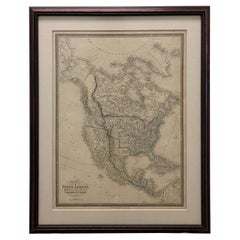
Framed 1838 North America & Recent Discoveries Map
Located in Stamford, CT
1838 map of North America & recent discoveries. Engraved color map by J. Wyld, London, England. This map shows Texas as a Republic without its panhandle.
Framed in brown carved wood...
Category
1830s American American Classical Antique Maps
Materials
Glass, Wood, Paper
Antique Lithography Map, Shropshire, English, Framed, Cartography, Victorian
Located in Hele, Devon, GB
This is an antique lithography map of Shropshire. An English, framed atlas engraving of cartographic interest, dating to the mid 19th century and later.
Superb lithography of Shrop...
Category
Mid-19th Century British Victorian Antique Maps
Materials
Wood

Antique Leicestershire Map, English, Framed Cartographic Interest, Victorian
Located in Hele, Devon, GB
This is an antique lithography map of Leicestershire. An English, framed atlas engraving of cartographic interest, dating to the mid 19th century and later.
Superb lithography of Le...
Category
Mid-19th Century British Victorian Antique Maps
Materials
Wood

Large 1856 Mexico & Guatemala Framed Map by Charles Desilver
Located in Stamford, CT
Large 1856 Mexico & Guatemala Framed map. Published by Charles Desilver, Philadelphia, Pennsylvania.
As found high end custom framing with black giltwood frame, custom matting and UV...
Category
1850s American American Classical Antique Maps
Materials
Glass, Wood, Paper

1834 Mexico & Guatemala Framed Map by H.S. Tanner
Located in Stamford, CT
1834 Mexico & Guatemala map of published by H.S. Tanner, Philadelphia, Pennsylvania. Engraved by J. Knight.
As found high end custom framing with carved wood frame, custom matting a...
Category
1830s American American Classical Antique Maps
Materials
Glass, Wood, Paper

An Ornate and Historical Tallis Map of Jamaica with Decorative Vignettes, 1851
Located in Langweer, NL
This original antique map of Jamaica is part of the renowned series created by the Tallis Company, known for their detailed and decorative maps ...
Category
1850s Antique Maps
Materials
Paper

Recently Viewed
View AllMore Ways To Browse
Nova Scotia Antique Furniture
Pilgrim Period Furniture
1500 Map
Albania Antique Map
Antique Gate Architectural Antiques
Antique Louisiana Map
Antique Map Louisiana
Antique Map Palestine
Antique Maps Of Louisiana
Antique Maps Of North Carolina
Armenia Map
Armenian Map
Brooklyn Map
Gibraltar Antique Map
Greenland Map
Hyde Park Antiques
Map Colorado
Map Of Armenia