Items Similar to An Ornate and Historical Tallis Map of Jamaica with Decorative Vignettes, 1851

Want more images or videos?
Request additional images or videos from the seller
1 of 7
An Ornate and Historical Tallis Map of Jamaica with Decorative Vignettes, 1851
About the Item
This original antique map of Jamaica is part of the renowned series created by the Tallis Company, known for their detailed and decorative maps of the 19th century. The company was founded by John Tallis, who was an English cartographic publisher. His maps are especially noted for their ornate borders and vignettes that illustrate various cultural and geographic aspects of the regions they depict.
The map itself is an intricate representation of Jamaica during the era of the British Empire, detailed with regions, towns, and geographical features such as mountains and rivers. Jamaica, an island in the Caribbean, was a British colony at the time this map was produced. It is known for its rich history, including its indigenous Taino people, Spanish conquest, and subsequent British colonization, and it was a significant hub in the transatlantic slave trade.
The vignettes surrounding the map offer a glimpse into the life and landscapes of Jamaica during the colonial period. They typically depict scenes of local importance or characteristic activities, giving additional context to the map itself. In this case, the scenes likely show various aspects of Jamaican society and economy, such as plantation life, which was a crucial part of the island's history given its role in sugar production.
The British Colonies by Robert Montgomery Martin, who was a colonial administrator, statistician, and author, is a comprehensive account of the British Empire's territories during the height of its power. His works provided detailed descriptions and statistics, aiming to inform the British public and officials about the vast expanse and diversity of the empire.
The Tallis maps, including this map of Jamaica, are collector's items today, prized for their beauty and historical value. They represent an era of extensive British exploration, colonization, and cartography, reflecting the Victorian interest in the broader world and the British role within it.
More details on the insets:
The insets on the map of Jamaica are detailed vignettes that illustrate various locales and features of the island, and they are a distinctive characteristic of John Tallis' maps. Here are the descriptions of the insets provided in the images:
1. **Port Antonio**: This vignette shows a coastal scene with a view of the town of Port Antonio. The image depicts several ships in the harbor and the town spread out along the coast, set against a backdrop of rolling hills or mountains in the distance. The foliage is lush, which is characteristic of the Jamaican landscape.
2. **Port Royal Harbour**: The vignette captures the serene waters of Port Royal Harbour with several boats sailing or docked in the calm bay. In the background, the Blue Mountains rise, which is a notable geographic feature of Jamaica known for its natural beauty and the famous coffee that is grown in its highlands.
3. **Seal of the Colony**: At the center of the top part of the map, there is the depiction of the "Seal of the Colony" which would be the official seal used during the British colonial administration. It represents the authority and governance of the time.
4. **Kingston**: This vignette features the city of Kingston, the capital and largest city of Jamaica. It shows a panoramic view of the city with buildings and vegetation. The scene is from a vantage point that looks over the city towards the harbor, showing a few ships and the ocean in the background.
5. **Fish with Wings (Flying Fish)**: The bottom vignette on the map shows a "fish with wings," which could represent a flying fish, a species known to frequent the waters around Jamaica. It adds an element of the local fauna to the map and highlights the island's rich marine life.
The combination of these vignettes with the highly detailed and ornamented map offers a window into Jamaica's landscapes, important cities, and maritime activities during the period. These picturesque and detailed insets would serve to make the map not just a navigational tool but also an item of interest to those appreciative of art, history, and geography. They are key selling points for the map, as they provide both beauty and a narrative element that can engage a potential buyer's interest.
- Dimensions:Height: 10.71 in (27.2 cm)Width: 14.26 in (36.2 cm)Depth: 0 in (0.02 mm)
- Materials and Techniques:
- Period:
- Date of Manufacture:1851
- Condition:Good given age. Original fold in middle as published. General age-related toning, please study scan carefully.
- Seller Location:Langweer, NL
- Reference Number:
About the Seller
5.0
Platinum Seller
These expertly vetted sellers are 1stDibs' most experienced sellers and are rated highest by our customers.
Established in 2009
1stDibs seller since 2017
1,922 sales on 1stDibs
Typical response time: <1 hour
- ShippingRetrieving quote...Ships From: Langweer, Netherlands
- Return PolicyA return for this item may be initiated within 14 days of delivery.
More From This SellerView All
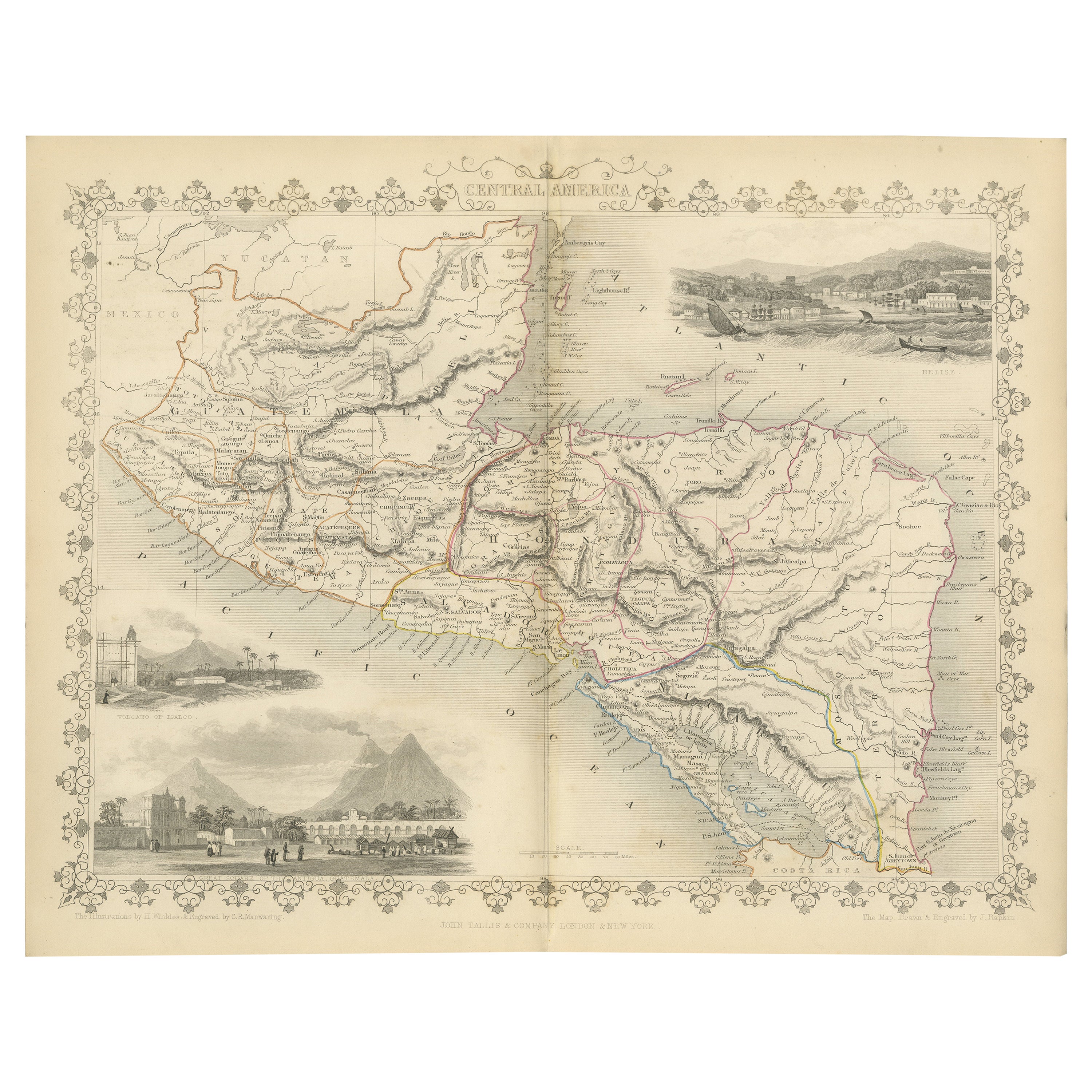
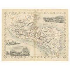
- An Old Illustrated Tallis Map of Central America with Volcanic Vignettes, 1851Located in Langweer, NLThis map of Central America, part of John Tallis & Company's series from "The British Colonies" by Robert Montgomery Martin, is a fine example of mid-19th century cartography and wou...Category
Antique 1850s Maps
MaterialsPaper
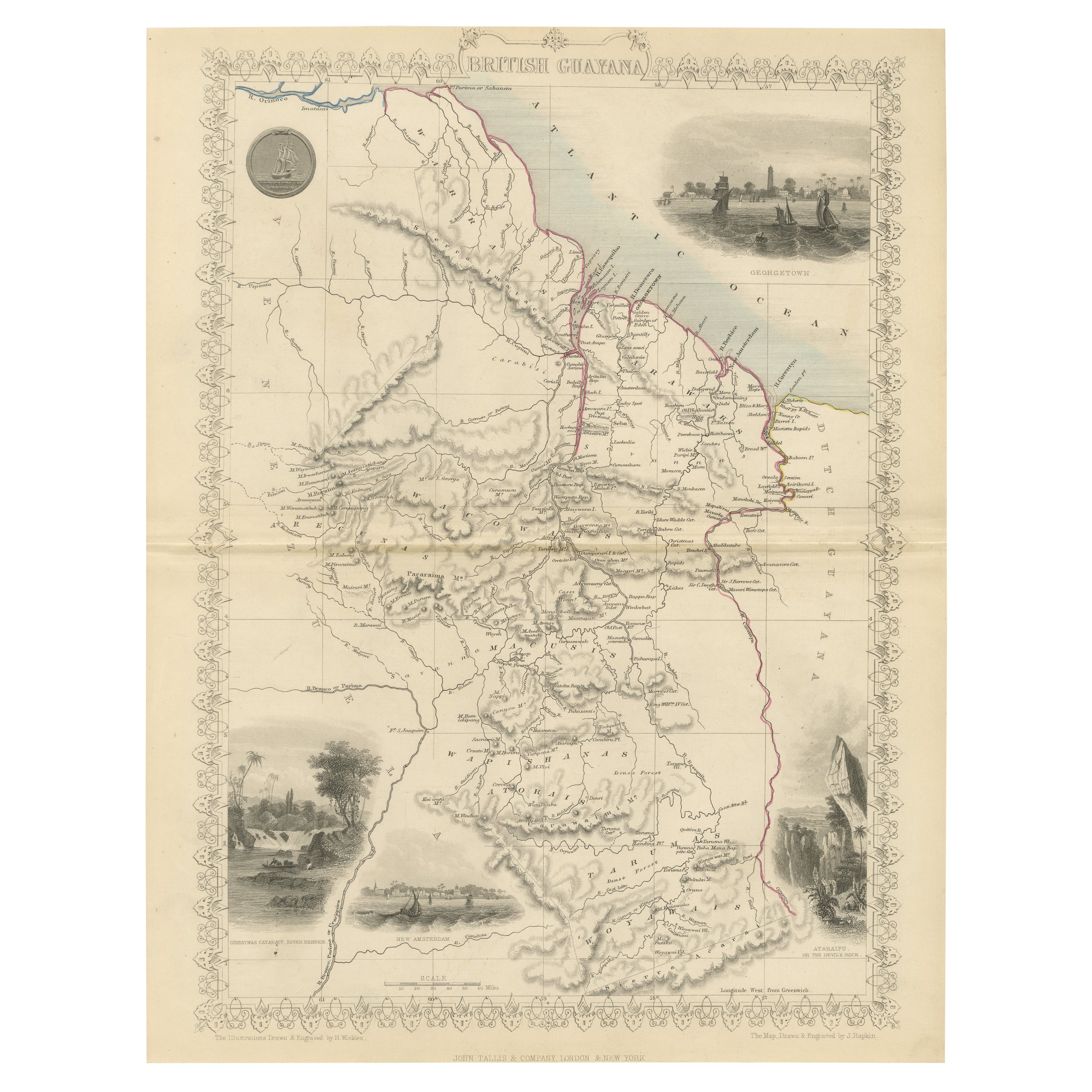
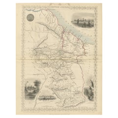
- A Tallis Map of British Guiana with Colonial Vignettes and Other Landmarks, 1851Located in Langweer, NLThis Tallis map of British Guiana (now known as Guyana) is a richly decorated document, much like other maps from the esteemed cartographic publisher John Tallis & Company. The firm,...Category
Antique 1850s Maps
MaterialsPaper
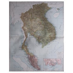
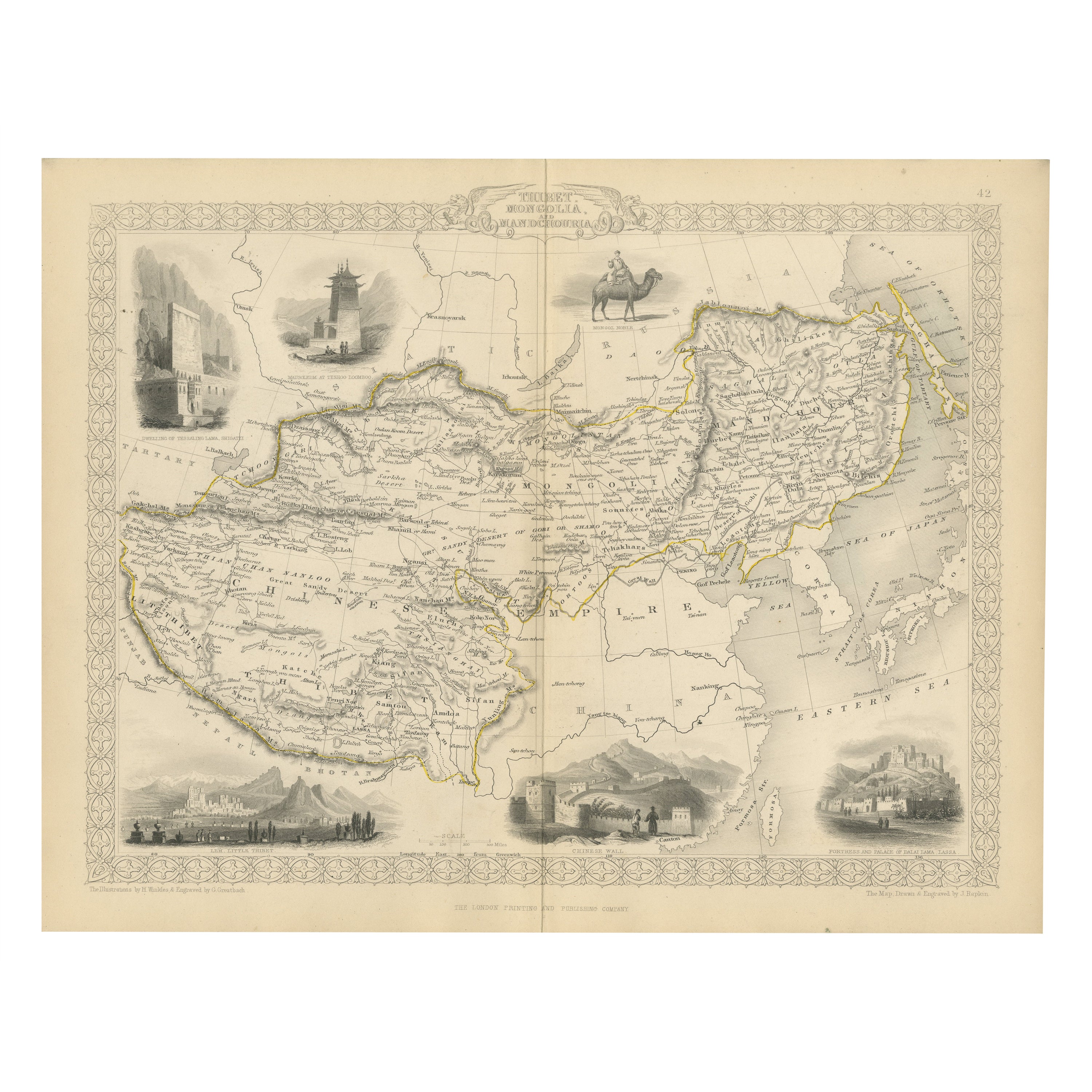
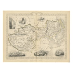
- Empires of the East: An Ornate Tallis Map of Tibet, Mongolia, and Manchuri, 1851Located in Langweer, NLThis original - with hand-colored borders- map of Tibet, Mongolia, and Manchuria is an example of the intricate work produced by John Tallis & Company, who were known for their detai...Category
Antique 1850s Maps
MaterialsPaper
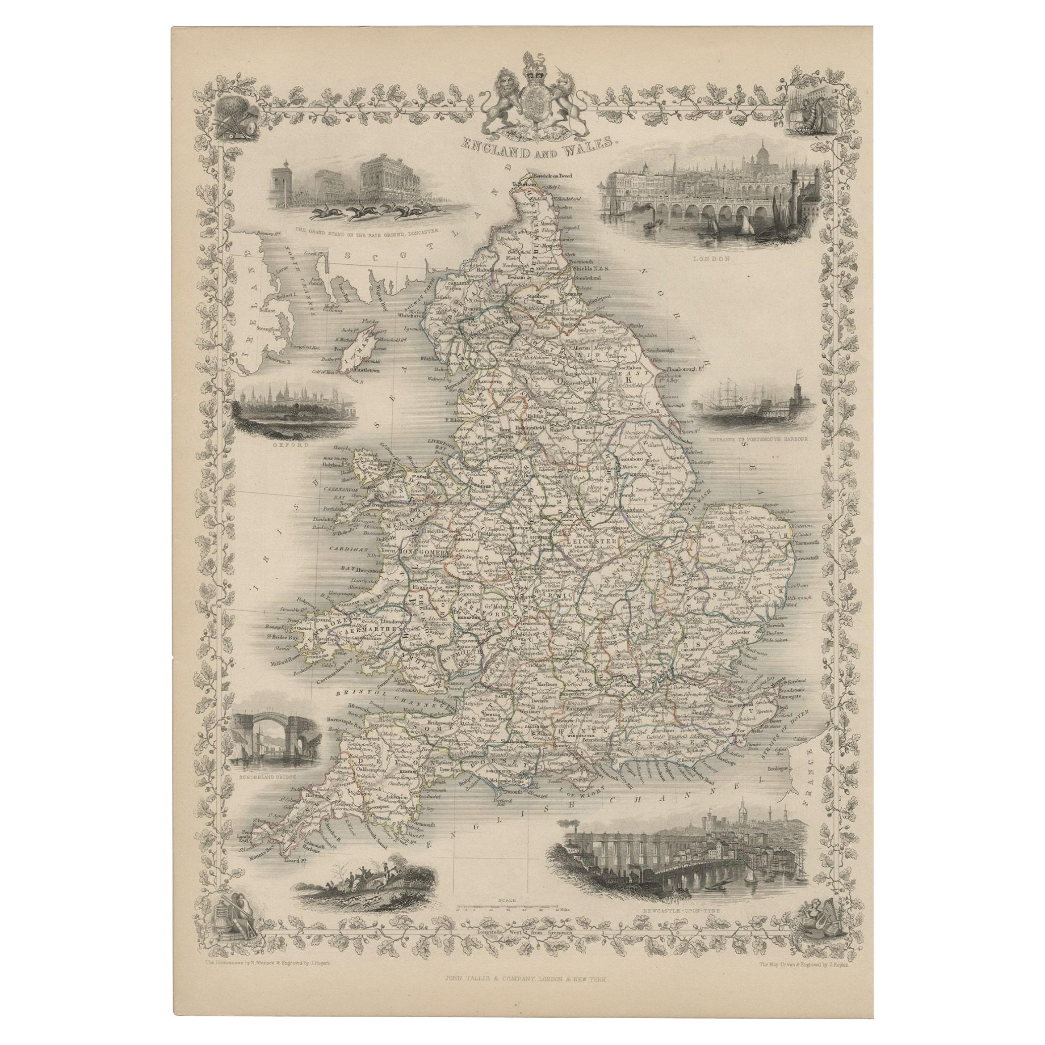
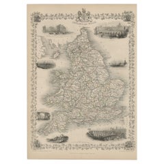
- Antique Map of England and Wales with Decorative Vignettes, 1851Located in Langweer, NLAntique map titled ‘England and Wales’. Includes decorative vignettes titled The grand stand on the race ground Doncaster, London, Oxford, Entrance to Portsmouth Harbour, Sunderland ...Category
Antique 19th Century Maps
MaterialsPaper
- Old Engraved Map of Hungary with Decorative Vignettes, 1851Located in Langweer, NLAntique map titled Hungary. Includes decorative vignettes titled Hungarian Peasants, Pesth and the Fortress of Buda, on the Danube and Hungarian Nobles. Originates from 'The Illustrated Atlas, And Modern History Of The World Geographical, Political, Commercial & Statistical, Edited By R. Montgomery Martin'. Published; John Tallis London, New York, Edinburgh & Dublin. 1851. Drawn and Engraved by J. Rapkin. Artists and Engravers: John Tallis (1817-1876) was a British map publisher. Born in the Midlands, Tallis came to London in the 1840s. Tallis began his London career with a series of remarkable London street views. He began a partnership with a Frederick Tallis, possibly his brother, but their collaboration ended in 1849. For the Great Exhibition of 1851, Tallis published the Illustrated World Atlas, one of the last series of decorative world maps ever produced. The maps were engraved by John Rapkin, a skilled artisan. The maps were later reissued by the London Printing & Publishing Company, who left the Tallis imprint intact, thus ensuring his enduring fame. In 1858, he began publication of the popular Illustrated News of the World...Category
Antique 19th Century Maps
MaterialsPaper
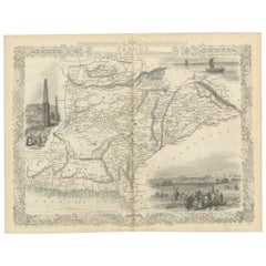
- An Illustrated Map of Kabul, Punjab, and Baluchistan by Tallis, 1851Located in Langweer, NLThis map, attributed to John Tallis and featuring the work of Robert Montgomery Martin, is part of a series created for the publication "The British Colonies." John Tallis & Company ...Category
Antique 1850s Maps
MaterialsPaper

You May Also Like
- Large Original Vintage Map of S.E Asia, with a Vignette of SingaporeLocated in St Annes, LancashireGreat map of South East Asia Original color. Good condition Published by Alexander Gross Unframed.Category
Vintage 1920s English Maps
MaterialsPaper
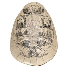
- Faux Albino Sea Turtle Shell Scrimshaw with American Historical VignettesLocated in West Palm Beach, FLFaux Albino Sea Turtle Shell Scrimshaw with American Historical Vignettes Circa 1980s, Simulated Tortoiseshell The faux albino sea turtle shell scrimshaw sculpture is a unique an...Category
20th Century Victorian Historical Memorabilia
MaterialsResin
- Original Antique Map of Belgium by Tallis, Circa 1850Located in St Annes, LancashireGreat map of Belgium Steel engraving Many lovely vignettes Published by London Printing & Publishing Co. ( Formerly Tallis ), C.1850 Origin...Category
Antique 1850s English Maps
MaterialsPaper
- 1851 Map of "Independent Tartary", Ric. R018Located in Norton, MA1851 Map of Independent Tartary "Russia" Ric.r018 A highly decorative 1851 map of Independent Tartary by John Tallis and John Rapkin. Covers the regions between the Caspian Sea and Lake Bakquash and between Russia and Afghanistan. These include the ancient Silk Route kingdoms of Khiva, Tartaria, Kokand, and Bokhara. Today this region roughly includes Kazakhstan, Uzbekistan, Turkmenistan, Kyrgyzstan, and Tajikistan. This wonderful map offers a wealth of detail for anyone with an interest in the Central Asian portion of the ancient Silk Road. Identifies various caravan routes, deserts, wells, and stopping points, including the cities of Bokhara and Samarkand. Three vignettes by W. Bragg decorate the map, these including an image of Tartars on a Journey, a horseback Bride Chase, and a tartar camp site. Surrounded by a vine motif border. Engraved by J. Rapkin for John Tallis's 1851 Illustrated Atlas . Tartary Antique Map...Category
Antique 19th Century Unknown Maps
MaterialsPaper
- Original Antique Map / City Plan of Brussels by Tallis, circa 1850Located in St Annes, LancashireGreat map of Brussels. Steel engraving. Published by London Printing & Publishing Co. (Formerly Tallis), C.1850 Free shipping.Category
Antique 1850s English Maps
MaterialsPaper
- "San Francisco, Upper California” 1851 Antique Map of San FranciscoLocated in Colorado Springs, COThis is a pictorial lettersheet view of the city and harbor of San Francisco. This lithograph was printed on grey wove paper, across a double sheet, by famed lithographers Britton & ...Category
Antique 1850s American Prints
MaterialsPaper