Items Similar to Empires of the East: An Ornate Tallis Map of Tibet, Mongolia, and Manchuri, 1851


Want more images or videos?
Request additional images or videos from the seller
1 of 7
Empires of the East: An Ornate Tallis Map of Tibet, Mongolia, and Manchuri, 1851
About the Item
This original - with hand-colored borders- map of Tibet, Mongolia, and Manchuria is an example of the intricate work produced by John Tallis & Company, who were known for their detailed and artistic maps in the mid-19th century.
**The Maker - John Tallis & Company:**
Tallis maps were distinctive for their ornamental borders and detailed vignettes. They often contained illustrations that provided a snapshot of the culture, geography, and significant landmarks of the region they represented.
**The Map - Tibet, Mongolia, and Manchuria:**
This map would have represented the regions of Central and East Asia, areas of great interest during the British Empire's expansion, though not directly controlled by the British. They would be significant for trade routes, exploration, and for the British understanding of global geography.
**The Countries:**
- **Tibet**: Known for its unique cultural heritage and as the home of Tibetan Buddhism, it's a region of high plateaus and significant religious landmarks.
- **Mongolia**: Characterized by its vast steppes and as the homeland of the Mongol hordes that once conquered much of the known world.
- **Manchuria**: Rich in natural resources, it has been a region contested by various powers due to its strategic importance.
**The Tallis Series:**
"The British Colonies" by Robert Montgomery Martin was intended to educate and inform the British public about the wide-reaching impact of the British Empire and to provide detailed information about regions that were important for British interests. While Tibet, Mongolia, and Manchuria were not British colonies, their inclusion in the series suggests a British interest in the wider geopolitical landscape of Asia.
Collectors and enthusiasts today value these maps for their beauty, historical significance, and the insight they provide into the British perspective of the world during the era of their greatest colonial expansion.
More details on the insets:
The insets on this map are detailed illustrations depicting significant landmarks and cultural representations of Tibet, Mongolia, and Manchuria. They were a common feature in the Tallis maps, intended to provide a visual narrative to accompany the geographic information. Here's a description of the insets:
1. **Leh, Little Tibet**: A panoramic view of the cityscape of Leh, the capital of Ladakh in the region historically known as Little Tibet. The architecture is clearly influenced by Tibetan style, with multi-story white-washed buildings tightly packed together against a backdrop of rugged mountains.
2. **Chinese Wall**: This vignette depicts a section of the Great Wall of China, showcasing its massive fortifications and watchtowers. The wall snakes over the mountains, with two figures in the foreground, likely to indicate the scale and to provide a human element to the scene.
3. **Fortress and Palace of the Dalai Lama, Lhasa**: An image of the Potala Palace in Lhasa, the historical seat of the Dalai Lama. The grandeur of the palace is evident, with its imposing position atop a hill, overlooking the city.
4. **Mongol Noble**: This inset shows a Mongolian nobleman riding a camel, depicting the traditional nomadic lifestyle of the Mongolian steppes. The attire and the saddle on the camel are detailed, indicating status and wealth.
5. **Dwelling of Teshoo Lama, Shigatse**: The Tashilhunpo Monastery is likely represented here, which is the traditional seat of the Panchen Lama, known as the Teshoo Lama in some historical texts. It shows a significant building within a rugged landscape, possibly signifying the monastery's religious importance.
6. **Mausoleum at Teshoo Loombo**: An illustration likely depicting part of the Tashilhunpo Monastery complex, which is the mausoleum and would house stupas or burial sites of important lamas.
These illustrations serve as a visual guide to the cultural and geographical features of the regions, providing an engaging supplement to the map. The Tallis maps are known for such embellishments, which made them part decor, part educational tool during the 19th century. They are now valuable for their historical perspective on the representation and understanding of these regions.
- Dimensions:Height: 10.71 in (27.2 cm)Width: 14.26 in (36.2 cm)Depth: 0 in (0.02 mm)
- Materials and Techniques:
- Period:
- Date of Manufacture:1851
- Condition:Good given age. Original fold in middle as published. General age-related toning, please study scan carefully.
- Seller Location:Langweer, NL
- Reference Number:
About the Seller
5.0
Platinum Seller
These expertly vetted sellers are 1stDibs' most experienced sellers and are rated highest by our customers.
Established in 2009
1stDibs seller since 2017
1,928 sales on 1stDibs
Typical response time: <1 hour
- ShippingRetrieving quote...Ships From: Langweer, Netherlands
- Return PolicyA return for this item may be initiated within 14 days of delivery.
More From This SellerView All
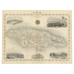
- An Ornate and Historical Tallis Map of Jamaica with Decorative Vignettes, 1851Located in Langweer, NLThis original antique map of Jamaica is part of the renowned series created by the Tallis Company, known for their detailed and decorative maps of the 19th century. The company was f...Category
Antique 1850s Maps
MaterialsPaper
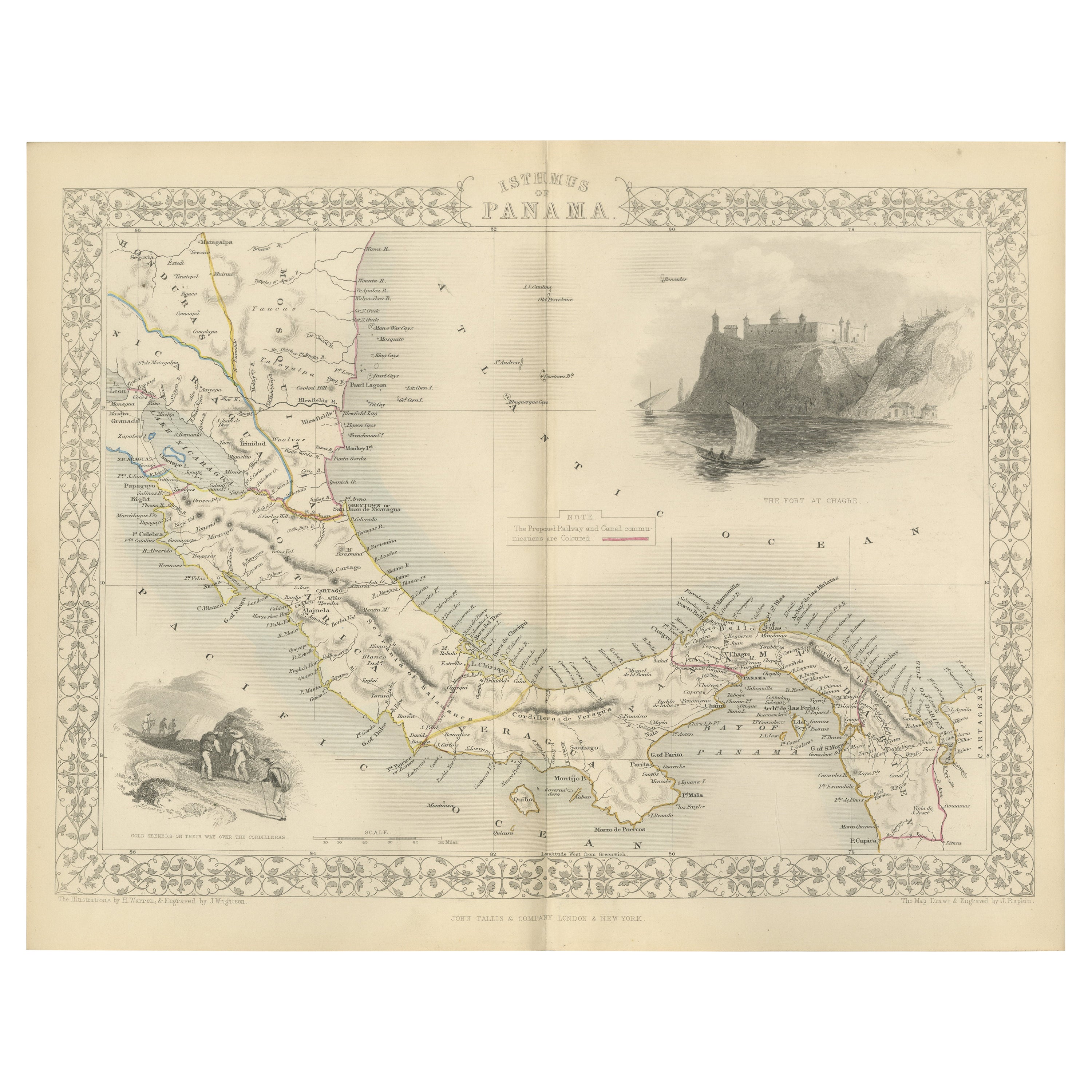
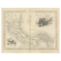
- Crossroads of Empires: A John Tallis Map of the Isthmus of Panama, 1851Located in Langweer, NLThe Tallis map of the Isthmus of Panama is a beautifully detailed work, characteristic of the maps produced by John Tallis & Company, which was one of the last cartographic firms to ...Category
Antique 1850s Maps
MaterialsPaper
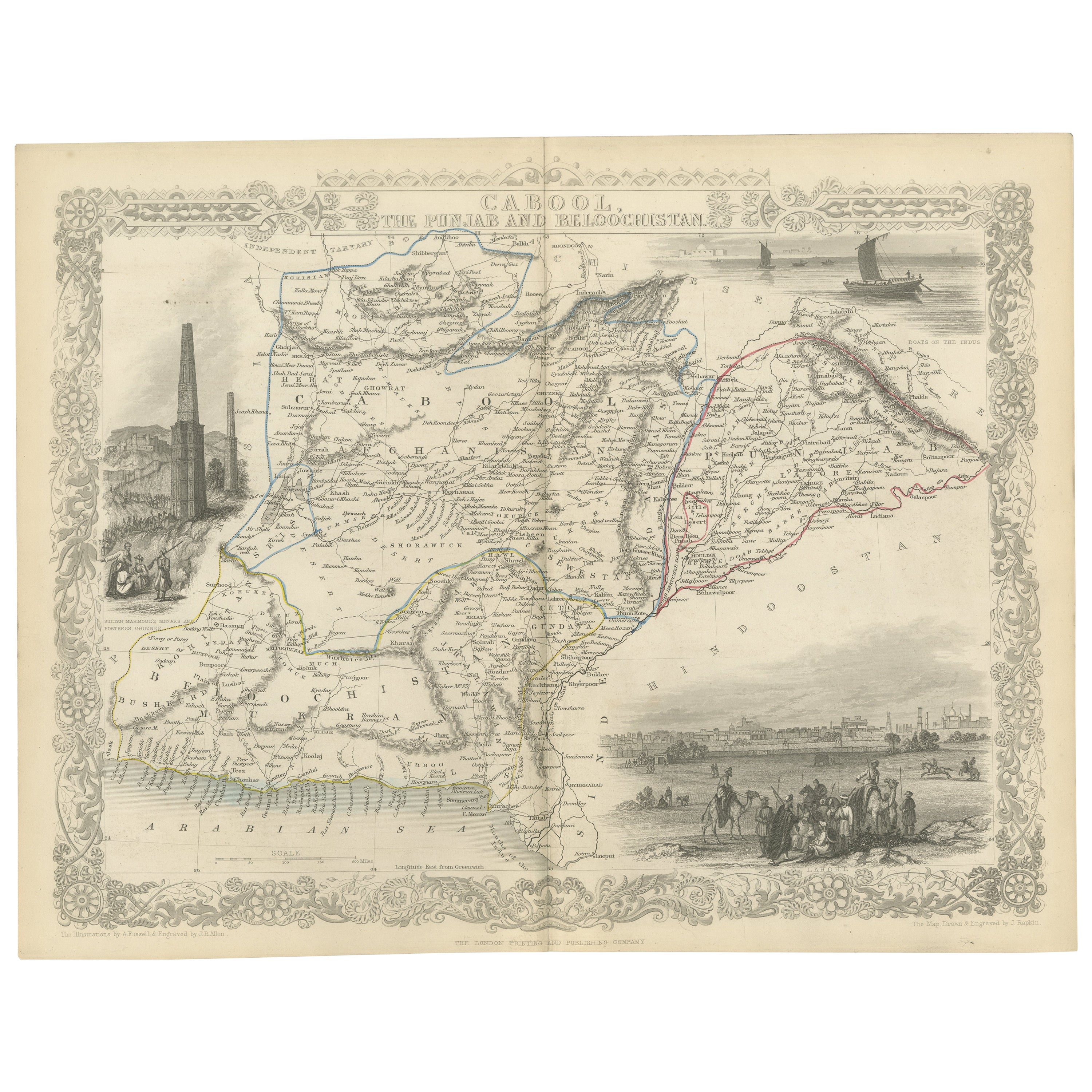
- An Illustrated Map of Kabul, Punjab, and Baluchistan by Tallis, 1851Located in Langweer, NLThis map, attributed to John Tallis and featuring the work of Robert Montgomery Martin, is part of a series created for the publication "The British Colonies." John Tallis & Company ...Category
Antique 1850s Maps
MaterialsPaper
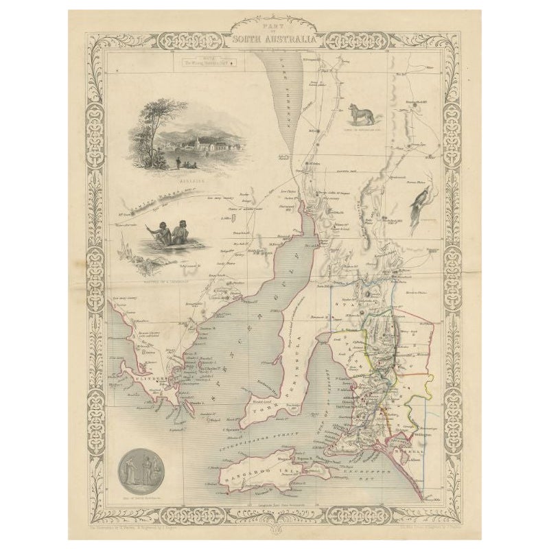
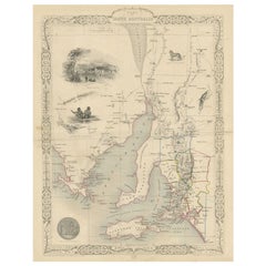
- Antique Map of South Australia by Tallis, 1851By Thomas KitchinLocated in Langweer, NLAntique map Australia titled 'Part of South Australia'. Decorative map of part of South Australia, surrounded by illustrations of Adelaide, natives on a catamaran, an Australian dog and a nymphicus bird illustrated. Originates from 'The Illustrated Atlas, And Modern History Of The World Geographical, Political, Commercial & Statistical, Edited By R. Montgomery Martin'. Published; John Tallis London, New York, Edinburgh & Dublin. 1851. Drawn and Engraved by J. Rapkin. Artists and Engravers: John Tallis (1817-1876) was a British map...Category
Antique 19th Century Maps
MaterialsPaper
- Antique Map of Belgium by J. Tallis, circa 1851Located in Langweer, NLA highly decorative and detailed mid-19th century map of Belgium which was drawn and engraved by J. Rapkin (vignettes by J. Marchant and J. B. Allen) an...Category
Antique Mid-19th Century Maps
MaterialsPaper
- Antique Map of Switzerland by J. Tallis, circa 1851Located in Langweer, NLA decorative and detailed mid-19th century map of Switzerland which was drawn and engraved by J. Rapkin (vignettes by A. H. Wray & J. B. Allen) and published in John Tallis's Illustr...Category
Antique Mid-19th Century Maps
MaterialsPaper


You May Also Like
- Original Antique English County Map, East Yorkshire, J & C Walker, 1851Located in St Annes, LancashireGreat map of The East Riding of Yorkshire Original colour By J & C Walker Published by Longman, Rees, Orme, Brown & Co. 1851 Unframed.Category
Antique 1850s English Other Maps
MaterialsPaper
- Original Antique Map of Belgium by Tallis, Circa 1850Located in St Annes, LancashireGreat map of Belgium Steel engraving Many lovely vignettes Published by London Printing & Publishing Co. ( Formerly Tallis ), C.1850 Origin...Category
Antique 1850s English Maps
MaterialsPaper
- 1851 Map of "Independent Tartary", Ric. R018Located in Norton, MA1851 Map of Independent Tartary "Russia" Ric.r018 A highly decorative 1851 map of Independent Tartary by John Tallis and John Rapkin. Covers the regions between the Caspian Sea and Lake Bakquash and between Russia and Afghanistan. These include the ancient Silk Route kingdoms of Khiva, Tartaria, Kokand, and Bokhara. Today this region roughly includes Kazakhstan, Uzbekistan, Turkmenistan, Kyrgyzstan, and Tajikistan. This wonderful map offers a wealth of detail for anyone with an interest in the Central Asian portion of the ancient Silk Road. Identifies various caravan routes, deserts, wells, and stopping points, including the cities of Bokhara and Samarkand. Three vignettes by W. Bragg decorate the map, these including an image of Tartars on a Journey, a horseback Bride Chase, and a tartar camp site. Surrounded by a vine motif border. Engraved by J. Rapkin for John Tallis's 1851 Illustrated Atlas . Tartary Antique Map...Category
Antique 19th Century Unknown Maps
MaterialsPaper
- East German MapBy VEB Hermann HaackLocated in Baltimore, MDA brilliantly colourful map of the Leipzig, Karl Marx Stadt and Dresden area in the former German Democratic Republic by VEB Hermann Haack of Gotha.Category
Vintage 1970s German Maps
- Original Antique Map / City Plan of Brussels by Tallis, circa 1850Located in St Annes, LancashireGreat map of Brussels. Steel engraving. Published by London Printing & Publishing Co. (Formerly Tallis), C.1850 Free shipping.Category
Antique 1850s English Maps
MaterialsPaper
- "San Francisco, Upper California” 1851 Antique Map of San FranciscoLocated in Colorado Springs, COThis is a pictorial lettersheet view of the city and harbor of San Francisco. This lithograph was printed on grey wove paper, across a double sheet, by famed lithographers Britton & ...Category
Antique 1850s American Prints
MaterialsPaper


